Tuesday, March 31, 2020

Were Hagoth’s Ships Canoes or Rafts, or Something Else? – Part I

The strength of Nephites and Lamanites moving north, firwst to Central and Mesoamerica, and much later to North America, hinges on the idea of Hagoth’s ships “that took their course northward” (Alma 63:) and that they “went to a land which was northward (Alma 63:4). Did Hagoth build ships of small size, as John L. Sorenson claims? Were they nothing more than large canoes with high sides? Were they rafts?
A large canoe capable of holding twenty people would hardly make it across the deep ocean

Such boats or rafts could move adequately on an inland river, or perhaps along the seashore, but that might be more difficult than it sounds. But either way, Mormon tells us these ships were launched into the West Sea (Alma 63:5). Mormon also informs us that these ships were exceedingly large (Alma 63:5). In addition, he also tells us that they were large enough for many men, women and children, along with much provisions to start a new life elsewhere (Alma 63:6).
    So how larger is “exceedingly large”?
    In the understanding of that word in Joseph Smith’s time, Noah Webster in his 1828 American Dictionary of the English Language, says it is: “To a very great degree; in a degree beyond what is usual; greatly; very much.” Today, the word is defined as “extremely; exceptionally; tremendously, immensely.” It might also be understood that the word “exceedingly” had its greatest use between 1817 to 1844, steadily tapering off after that time to a low in the year 2000.
    In Hebrew, the word exceedingly מְאֹד (meod) meant “abundantly, excessive, extremely, great, immensely, very.” Of the 50 different meanings in the Old Testament, found in 287 instances of use, it was translated as “very” in 139 of those uses; “great or greatly” 68 times; “exceedingly” 14 times, and all the others being used only once or twice, the word in the Bible basically meant “very great or greatly.”
    So we can conclude that the word “exceedingly” as used in the Book of Mormon as an adjective carried the descriptive meaning of “very large ship,” or “greatly large ship,” which by the stretch of anyone’s imagination could not be a raft or large canoe.
    In addition, we need to consider that in Hagoth’s time, around 55 BC, the Nephites had been in the Land of Promise over 500 years, and in Zarahemla 150 to 200 years. In all that time Helaman lists and Mormon verifies that the Nephites were involved in “shipping and the building of ships” as one of their major areas of endeavor (Helaman 3:14). Thus, the Nephites were somewhat of a maritime people who not only built ships, but these ships were used for commercial purpose.
The Land of Promise was an island surrounded by water with numerous inland rivers requiring a shipping industry

Obviously, these earlier ships would have been small, but still larger than Sorenson’s raft or large canoe, but in either event, what Hagoth built was much larger than that. So why did Mormon single out Hagoth? Evidently, because he built ships quite differently than those ships built before his time. So what do we know about this man that backs up such a claim?
First: he was likely a Nephite
Second: He was probably a wealthy man for he constructed a shipyard large enough to build several ships within a few years;
Third: He was a very curious man.

    Now while many theorists conclude from this that Hagoth was an explorer and sailed out with the ship he built, the scriptural record does not suggest this. Thus, he did not set sail with his first ship which carried large numbers of emigrants on a course northward, for he remained in his shipyard building other ships when the first ship returned (Alma 63:7). In addition, there is no mention or suggestion that Hagoth ever went anywhere in any of his ships.
    Now we come to the word curious—it was not only about having a “Strongly desirous to see what is novel, or to discover what is unknown; solicitous to see or to know; inquisitive.”
    But it also meant:
2. Addicted to research or inquiry.
3. Accurate, careful, solicitous to be correct;
4. Attentive (as to detail);
5. Difficult to please; exact,
6. Make with care; artful; wrought with care and art;
7. Elegant; neat, finished (as curious work);
8. Particular; exactness of workmanship.”
    Thus, we can conclude the Hagoth was a maker of things unusual—ships that were exceedingly large that transported large numbers of people to distant lands.
    It is also seen that Hagoth and Mormon’s description of the man, his work, and results have been misunderstood by Mesoamerican, Heartland and other theorists, and who misrepresent him in their writing.
    Regarding this, we might ask:
2. What was the size and design of Hagoth’s ships? Some Mesoamerica scholars, such as John L. Sorenson, suggest that Hagoth’s ships were little more than very large dugout canoes with built-up sides or log rafts with sails, and certainly not complex planked vessels resembling later European ships. However, the facts do not seem to bear this out. So according to the scriptural account, one of these exceedingly large ships:
An ancient single sail ship driven forth before the wind

• Was big enough to accommodate a very large number of men, women and children;
• Was, in addition to carrying people, big enough for extensive immigrant provisions meant for colonization, which might have included domestic animals, such as cows, goats or sheep;
• Was built by a master craftsman who constructed other ships;
• Was seaworthy enough that after nearly a year at sea was immediately able to embark on a second, lengthy voyage, apparently without repairs.
    This hardly sounds like a dugout canoe or log raft, no matter how large. While a group of adventurers might undertake such a voyage upon a meager craft, such as Thor Heyerdahl and his group on Kon-Tki, and other raft vessel voyages, men seldom venture forth with their wives and children in such dangerous or tenuous circumstances, especially with the intent of migration.
    Consequently, since they were taking families and supplies on this voyage, and many people were involved, these ships had to have been quite large, and obviously more involved than simple dugouts or rafts. In fact, Mormon calls them “exceedingly large ships” (Alma 63:5)
(See the next post, “Were Hagoth’s Ships Canoes or Rafts, or Something Else? – Part II,” for more on the construction of Hagoth’s ships that carried emigrants to a land :”which was northward.”

Monday, March 30, 2020

Mormon Describes the Land Running North and South

Despite the many theories that have been and are being represented by models of lands that do not match Mormon’s descriptions, the area of the Narrow Neck of Land remains quite controversial among theorists. Everyone simply chooses  the best place they have to call the narrow neck and promote it as such.
    Mormon’s words are quite specific: “There being a small neck of land between the Land Northward and thel and Southward” (Alma 22:32).
The small neck of land between the Land Southward and the Lord Northward forming a large Land of Promise in the midst of the sea 

Mormon makes it very clear that in the Land of Promise, there was a seashore on the West (Alma 22:28) and a seashore on the East (Alma 22:29). He also tells us that the Land of Nephi, which the Lamanites occupied, was to the south (Alma 22:33) of a narrow strip of wilderness (Alma 22:27), and the Nephites occupied all the land to the north (Alma 22:29), and that the Land of Bountiful was to the north of the Land of Zarahemla (Alma 22:29) and to the north of Bountiful was the Land of Desolation (Alma 22:31). There was a small neck of land (Alma 22:32), also called a narrow neck of land (Alma 63:5), that could be crossed in a day and a half (Alma 22:32), that lay between the Land Northward and the Land Southward (Alma 22:32).
The Land Southward was nearly surrounded by water

When Mormon describes the Land Southward, he tells us it is nearly surrounded by water (Alma 22:32), with only a narrow neck of land that connects the Land Southward with the Land Northward keeping it from being completely surrounded by water.
    It is important for us to keep in mind that Mormon became the General of the Armies at the age of 16 years (Mormon 2:2), and for the next fifty-eight years he led the Nephites in many battles to defend his people against the Lamanites. In all this time he walked back and forth across the entire Land of Promise, from then narrow strip of wilderness in the far south to the narrow neck of land in the north, and eventually retreated with his troops all across the Land Northward, ending up in the far, far north at the hill Cumorah in the Land of Many Waters where he fought his last, great battle.
    In all that time, Mormon, as the General of his armies, mapped out the land, looked for strategic area of advantage (Mormon 6:4), knew where the waters, rivers, paths and roads lay and used them to move his troops in their many retreats across the land. In all of this it would be obvious that Mormon knew and understood the terrain over which he led his troops.
Mormon going through the plates he had abridged

In all that time Mormon also abridged the entire Book of Mormon, knowing he was writing it for us in our day, and made many clarifying comments, which he inserted into the descriptions, like Alma 22:27-35, as did his son, Moroni, in abridging the Book of Ether, as in Ether 12:20 through Ether 13:1.
    Mormon knew when he traveled north, northward, east or west. He understood the directions of his land as any military leader would whose safety and success his soldiers rely on. There can be no question that when Mormon wrote “north,” he not only knew it was north, but meant for us to understand it was north.
    In fact, Mormon in the Book of Alma alone, uses directions 125 times: North 37 times, South 22 times, East 35 times, and West 31 times. One should conclude from this that Mormon knew and understood the directions of the land and used them continually so we would have a better understanding of the layout of the Land of Promise.
Liahona showed Lehi whereto travel and in which direction they were traveling

In the one incident in the Book of Mormon dealing with a compass, Lehi found a curious object. When he “arose in the morning, and went forth to the tent door, to his great astonishment he beheld upon the ground a round ball of curious workmanship; and it was of fine brass. And within the ball were two spindles; and the one pointed the way whither we should go into the wilderness.
    Following, we find Nephi using correct cardinal directions when he described the party moving down beside the Red Sea “we traveled for the space of four days, nearly a south-southeast direction, and we did pitch our tents again” (1 Nephi 16:13), and Nephi adds, “And we did follow the directions of the ball, which led us in the more fertile parts of the wilderness” (1 Nephi 16:16).
Lehi traveled south-south east, then turned nearly eastward

Later, when they changed direction, he wrote: “we did again take our journey in the wilderness; and we did travel nearly eastward from that time forth” (1 Nephi 17:1). Still later, Nephi referred to the ball as a compass (1 Nephi 18:12), with Mormon also calling it a compass (Alma 37:43), and also the Liahona (Alma 37:38).
    Obviously, both Nephi and Mormon knew the cardinal directions—they both had the Liahona, or compass, and both wrote about directions. Mormon was very careful to list exact directions of travel and places for our better understanding of his north-south Land of Promise
    Therefore, when Mormon writes north, east, south or west, he fully understands those directions, as did Nephi. Consequently, when Mormon inserted his remarks in the writing of Alma, making up verses 27-34 of Alma 22, he knew exactly what direction he was indicating. Thus, we have a completely factual layout of the Land of Promise, when we start in the far southwest of the land and place the spot where Lehi landed, called “their fathers’ first inheritance” (Alma 22:28), the Land of Nephi to the north of the narrow strip of wilderness “which ran from the sea east to thre sea west” (Alma 22:27), and the Land of Zarahemla to the north; and to the north of that was the Land of Bountiful (Alma 22:29), and north of that was the Land of Desolation (Alma 22:30-31), and north of that was the the area of the Jaredites (Alma 22:30), which was the Land of Cumorah, which was in the Land of Many Waters (Mormon 6:4).
    When Mormon describes his movement as his men retreated from the attacking Lamanites, it is all north or northward. While he mentioned west once, and east not at all, he lists north and south 9 times. There simply wasn’t anywhere to the east or west for hm to go. Even the Jaredites moved north and south, mentioned 11 times to east/west only twice. Thus, we see, a long, narrow land, surrounded by four seas (Helaman 3;8).

Sunday, March 29, 2020

Lehi’s Isle of the Sea

While we have written about this before, it still remains one of the single most obvious deterrents to the many theorist claims for the location of the Land of Promise—and the most ignored of any other variance. In fact, theorists are extremely adamant in denying the meaning of the word “isle” as meaning “island,” but claim its actual meaning is very different. It is also one of the reasons that scholars and members do not consider South America as the Land of Promise, not knowing or believing the Andean west coastal waters were once an island.
    Thus, a lot of erroneous information has been suggested and written about Lehi’s promised isle of the sea. Most theorists, whose models do not include an island, try to cloud the issue by changing the meaning of the scriptural reference stated by Jacob:
    “We have been driven out of the land of our inheritance; but we have been led to a better land, for the Lord has made the sea our path, and we are upon an isle of the sea.” (2 Nephi 10:20)
    So what are the “isles” of the sea? Modern theorists trying to explain away the idea of isles meaning islands, claim the early writers of the Old and New Testaments were unfamiliar with far-off lands, and referred them simply as islands, meaning the land inland from the coastal seas, no matter the size of that land.
    Other Bible scholars claim that the word “isle” meant any land as opposed to water, or maritime district, whether belonging to a continent or to an island, and claim that the wordage of Jacob simply meant a far off land. However, scriptural references by Old Testament writers do not back up that theory.
Old Testament authors new and wrote more about distant lands than modern theorists believe

As an example, these writers referred to numerous far-off lands by name, some of which we don’t know their meaning without looking up their location in an historical Atlas dictionary. In fact, research into Akkadian, Egyptian, Hittite, Hurrian, Canaanite, Ugaritic histories have been retrieved, along with their writing systems, making ancient archives accessible once again, along with a better understanding of the past than at any earlier time. This research into the ancient Near East has uncovered much lost information about the history and annals and their vast treasuries of documents and texts cast a clear light on the lands of the Bible, where they were, what they were called, and how they were seen and understood.
    As an example, the early Israelites knew and understood the world around them. The Bible is full of writings about far off lands, and not mentioned as isles of the sea regarding coastal land of unknown areas, but as specific land-based places.
A few of these examples would be: Mesopotamia, Judea, Cappadocia, Pontus, Asia, Galatia, Bithynia and Optimatoi (Acts 2:9; 18:2; 1 Peter 11:1), the land of Mannae, Media (Amos 4:3), Eiujj or North Gomer, North Pontic (Herodotus 4:12); Caphtor (Jeremiah 47:4), Cush (Isaiah 20:6), Pathros and Shinar (Isaiah 11:1), to name a few.
    There are 6,000 islands in Greece scattered in the Aegean and Ionian Seas, an area well known to those of the ancient Middle East, including major islands such as Crete and Cypress, along with Rhodes, Saria, Tilos, Simos, Kasos, Kos, and Nikia islands, as well as numerous others on the way to Ephesus, Galatia, Corinth, Philippi and Thessaloniki.
    Further, Pontus (Pontos), mentioned several times in the Old Testament, was a far off important province in the northeastern part of Asia Minor, lying along the south shore of the Black Sea (modern day Turkey), it was first used to designate that part of Cappadocia which bordered on the "Pontus," as the Euxine was often termed. This was the area of Gamir, a region the early Cimmerians, otherwise known as "Gomer," appeared in. Pontus extended from the Halys River on the West to the borders of Colchis on the East, its interior boundaries meeting those of Galatia, Cappadocia and Armenia. All of this was known to the Old and New Testament writers. The Hebrew also knew of Pathros, which was far to the south beyond Egypt.
The known world to the Hebrews during the Old Testament time

It should also be kept in mind that at the time of the Biblical writings, much of the world had not as yet been discovered, and those in the Mediterranean lands (Biblical lands) knew almost nothing of any lands or events outside the Mediterranean world—north to Trace and along the coast, east to Persian (Iran), South to Egypt and Cush (Ethiopia) and west to the Atlantic Ocean. By the time of the Roman Empire, that knowledge had extended to Gaul and Britain and Germania in the north, and the west to Morocco and Spain—the rest of the world was referred to as the four corners of the earth.
    The entire Western Hemisphere, of course, had not been discovered, nor had the thousands upon thousands islands of the South Pacific or even Indonesia. Just because some scholars today want to claim the historians of the Old Testament used the term “isles” claiming they referred to unknown lands, it is highly unlikely they knew far more about these so-called far off lands than modern theorists believe.
    The modern interpretation of the word “isle” is that it means “coast” or” coast-land” (America Standard Revised Version; however, Noah Webster’s 1828 American Dictionary of the English Language, isle is defined as: “A tract of land surrounded by water, or a detached portion of land embosomed in the ocean,” and quotes “The isles shall wait for his law” Isaiah 42:4). Webster also defined “island” in 1828 as “A tract of land surrounded by water,” but adds: “This is an absurd compound of isle and land, that is, land-in-water land, or ieland-land. There is no such legitimate word in English.”
    Thus, when Joseph Smith translated the plates, he used the word “isle” in translating Nephi’s writing of Jacob’s wordage, since the word “island,” which we would use today, was not in use in America at Joseph’s time.
    It is also important to remember that the Prophets spoke in their language according to terms familiar to them. They spoke the truth. The names given by the Prophets to different places in connection with future events may be the same places that had those names at that time; or they may be different places to which descendants of the same people moved; or they may have had names that sounded similar to the names the Prophets employed—such as Hamath being an important city in northern Syria, but you also had Ecbatana (the capital of Media), known as Hamadan, and according to the commentary by modern Hebrew Bible Scholar Da’at Mikra that Hamath was the term for the Bible.
    Isaiah, one who discusses islands more than any other Old Testament writer, made it clear that there was a difference between the use of “isles” and those far-off lands which he simply stated as the “four corners of the earth” (Isaiah 11:1-2). And he knew what a coastland was. Which brings us to Lehi, who sailed to one of those islands in the midst of the sea to the land the Lord promised him.
The ancients knew what an island was, they knew of Cyprus and Crete and understood them as being islands, and also the nearby islands of Greece—to them far off lands were those out of their range of knowledge, and trusted in the Lord who said there were people in far off lands

Keeping in mind that an “isle” of the sea is an “island,” the Nephites had sailed across the ocean and landed upon an island in the midst of the sea, which Jacob well understood, having been on the ship that brought them to the Land of Promise and observing their approach to that land. Thus, when the Nephites began to fear their separation from Jerusalem and whether or not God knew where they were in their new home, Jacob told them: “And now, my beloved brethren, seeing that our merciful God has given us so great knowledge concerning these things, let us remember him, and lay aside our sins, and not hang down our heads, for we are not cast off; nevertheless, we have been driven out of the land of our inheritance; but we have been led to a better land, for the Lord has made the sea our path, and we are upon an isle of the sea. But great are the promises of the Lord unto them who are upon the isles of the sea; wherefore as it says isles, there must needs be more than this, and they are inhabited also by our brethren” (2 Nephi 10:20, emphasis added).
    There simply is no way that these two verses that “isles” can be interpreted as being communities locations on a landmass,” but as “separate lands as would be found on islands scattered in various areas around the Earth.
    In addition, Mormon tells us that Lehi landed along the West Sea toward the south along the seashore when he said, “on the west in the land of Nephi, in the place of their fathers' first inheritance, and thus bordering along by the seashore” (Alma 22:28). He also described the Land of Nephi that extended as he said from that West Sea clear to the East Sea, as did the Narrow Strip of Wilderness that separated that land from the Land of Zarahemla (Alma 22:27-28), and that the lands of Nephi and Zarahemla were surrounded by water except for a “small” neck of land (Alma 22:32), along with the comment  that the Nephites had spread “from the land southward to the land northward, and did spread insomuch that they began to cover the face of the whole earth, from the sea south to the sea north, from the sea west to the sea east” (Helaman 3:8)—all of which suggests quite clearly that the Nephites were on an island.
    There seems little doubt, based upon the numerous scriptural comments about “isles” of the sea that they “mean an island,” consequently, for any Land of Promise to receive serious consideration, it must be shown that at the time of Nephi, it was an island. No other area suggested for this Land of Promise is based on an area now, or in the ancient past, as being an island, except for that of Andean South Carolina, which we have written about many times in these articles.

Saturday, March 28, 2020

What was Mulek’s Course to the Land of Promise? – Part IV

Continuing from the previous post regarding how Mulek and those with him reached the Land of Promise and what route they took and what routes they did not take that are popular among theorists. The first three routes have been discussed in the previous posts. Below is the fourth of these possible four ways for Mulek to have taken.
The fourth and most accurate course, around Australia and across the Pacific, to the area of today’s Lima at an area called Pachacamac in Peru 

4. He left the Arabian Peninsula and sailed in the same direction that the Lehi Colony took, down through the Indian Ocean and into the Southern Ocean, picking up the Prevailing Westerlies in the West Wind Drift and eastward across the southern Pacific Ocean to the west coast of South America, then landing on the west coast of the Land of Promise.
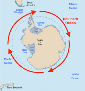
    In this fourth course, Mulek followed the path of Lehi, sailing south and southeast through the Indian Ocean on the Indian Ocean counter-clockwise gyre and picking up the eastward-flowing Southern Ocean. These waters are the southern-most ocean that unimpeded circles the globe and the newest-named ocean basin. It is unbroken by any land mass and moves unrestricted around the world with its narrowest point the Drake Passage, whichvis 600 miles wide between South America and the tip of the Antarctic Peninsula.
Red Arrows: The Southern Ocean circles the globe free of any land mass; Broken lined circle: the Antarctic Circle

To see why the Lord chose to send all three groups, the Jaredites, Lehi and Mulek, down around the Southern Ocean is best inferred when we understand the ocean itself and the currents involved on which a ship, “driven forth before the wind,” would be propelled forward.
    First of all, the flow of currents in the Southern Ocean is complex. Water cooled by cold air, outgoing radiation, and katabatic winds, or those that blow downhill or downslope because of gravity, often called gravity wind, off of the Antarctic continent sinks and flows northward along the ocean bottom and is replaced at the surface by an equal volume of warmer water flowing south from the Indian, Pacific, and Atlantic oceans.
    This process is most pronounced in calm air because winds mix the air and prevent cold pockets from forming. When this katabatic wind is warmed by compression during its descent into denser air, it is called a foehn—a warm and dry, gusty wind that periodically descends the leeward slopes of nearly all mountains and mountain ranges. The name was first applied to a wind of this kind that occurs in the Alps, where the phenomenon was first studied.
    It results from the ascent of moist air up the windward slopes; as this air climbs, it expands and cools until it becomes saturated with water vapor, after which it cools more slowly because its moisture is condensing as rain or snow, releasing latent heat. By the time it reaches the peaks and stops climbing, the air is quite dry. The ridges of the mountains are usually obscured by a bank of clouds known as a foehn wall, which marks the upper limit of precipitation on the windward slopes. As the air makes its leeward descent, it is compressed and warms rapidly all the way downslope because there is little water left to evaporate and absorb heat; thus, the air is warmer and drier when it reaches the foot of the leeward slope than when it begins its windward ascent.
    This means that the air in the Southern Ocean, that should be very cold, being so close to the Antarctic, is actually warmer as these effects take place, allowing for a milder passage on the Southern Ocean; at the same time where ancient, deep ocean water is upwelled to the surface and bringing deep nutrients upward, while modulating the water temperature between the warm tropical waters from the north and the cold arctic waters from the south.  However, such a passage is fraught with the stress and speed of the movement of the current.
Dotted Line: Mulek’s course to and around the Southern Ocean. Note how much shorter around the globe the red latitude is from the blue latitude or equator

The result is a quick movement across this southern Circumpolar Current, which is the world’s strongest ocean current, shortened even more by the fact that the globe is shorter around as the world diminishes toward the poles. With the Equator at 0º latitude, this means that the higher the latitude (50º south latitude), the shorter the distance around the globe. Rather than going straight across the Pacific around the equator as John L. Sorenson and other Mesoamerican theorists claim, or straight across the Mediterranean and Atlantic as Heartland and Great Lakes  as well as others claim, the distance in the Southern Ocean is far less and would require a much shorter route and voyage.
    In addition, those who claim Lehi and Mulek sailed around the Cape of Good Hope in the southern tip of Africa, then up and across the Atlantic to the Gulf of Mexico or eastern U.S. would be sailing even further, since there would be extra distance vertically and no benefit from a southern latitude.
Cape of Good Hope, originally called the Cape of Storms because of the turbulent weather and ocean currents

It should also be noted, as we have written in earlier articles, the waters around the Cape Peninsula of Africa is fraught with dangers. From the time of Eudoxus, who tried to sail around the tip of Africa, but found the difficulties too difficult land returned unsuccessful in 130 BC. On his second voyage, he and his ship were lost in the attempt to reach the other ocean beyond Africa.
    For centuries, the Cape has been considered a “Death Route” until steam and then diesel engines were used. When Bartolomeu Dias finally made the voyage from the Pacific to the Indian ocean in 1488, he encountered such tempestuous weather and counter currents, that he named the cape Cabo das Tormentas, the Cape of Storms. In fact, some storms in this area can last up to forty days and make sailing impossible. However, to encourage the exploration of Africa and the Orient in an effort to reinvigorate the Portuguese economy, king John II of Portugal renamed the cape (Cabo da Boa Esperança), Cape of Good Hope.
    However, as a symbol of the horrendous forces of nature in these waters that early Portuguese navigators had to overcome during their discoveries, and more specifically of the dangers Portuguese sailors faced when trying to round the Cape of Storms, poets and writers created numerous mythical figures. One of which was the Flying Dutchman, a ship crewed by tormented and damned ghostly sailors, doomed forever to beat its way through the adjacent waters without ever succeeding in rounding the headland of the Cape.
    Another was Adamastor, a Greek-type mythological character invented in the poem Os Lusiadas (Discovery of India) who was banished to the Cape where he appeared out of storm clouds and threatened to ruin anyone hardy enough to attempt passing the Cape, which was his domain. Adamaster became the spirit of the Cape of Good Hope, as a symbol of the forces sailors faced around the Cape and was a hideous phantom of unearthly pallor (Luis Vaz de Camoëns, Poem: The Lusiad, translated by William Julius Mickle, George Bell and Sons, London, 1877).
De Gama conversing with Adamastor sailing around the Cape of Africa
  
Of this it was written that Vasco da Gama, at the head of the Portuguese expedition, confronted the creature by asking "Who are you?" prompting Adamaster to reply:  
“I am that vast, secret promontory
you Portuguese call the Cape of Storms
which neither Ptolemy, Pompey or Strabo,
Pliny, nor any authors knew of.
Here Africa ends. Here its coast
Concludes in this, my vast inviolate
Plateau, extending southwards towards the Pole
And, by your daring, struck to my very soul.” 
— Camões, The Lusiads Book V
These stories and poems were meant to symbolize the extreme dangers associated with sailing around the Cape and any voyage in antiquity that attempted it would have been exceptionally dangerous, in fact the area was referred to as the Graveyard of Ships, where it is said hundreds of ships were lost. 
    It is easy today for one to look at a flat map of the world and traced a course with their fingertip, but the reality of any course, which is not shown or suggested on map, can be extremely difficult and often without merit simply because of a lack of understanding what is involved. The course Lehi and later Mulek took down to the Southern Ocean, past Australia, across the Pacific and up along South America would have been the simplest course and involve the least amount of navigation and sailing skill of the other courses, the most likely of success for an inexperienced crew.


Friday, March 27, 2020

What was Mulek’s Course to the Land of Promise? – Part III

Continuing from the previous post regarding how Mulek and those with him reached the Land of Promise and what route they took and what routes they did not take that are popular among theorists.
    In the previous two posts, the first suggestion of sailing out of the Mediterranean was shown to be next to impossible because of the political environment of the time.
The second course, eastward through Indonesia to Mesoamerica

Below is the second suggested course:
2. Mulek left the Arabian Peninsula and sailed directly east, around India and through Indonesia and then across the Pacific Ocean to land on the west coast of Central America.
    In this second course, any passage eastward from the coast of Arabia would be impossible for an ocean vessel capable of sailing across deep water, a scenario thoroughly discussed in the book “Lehi Never Saw Mesoamerica.” In short, the winds and currents would be against such a voyage the entire ten thousand miles to the Americas in the Western Hemisphere.
    The winds and currents flow from the Pacific Ocean westward in the opposite direction the ship would have to sail, and when those currents and winds hit Indonesia, they continue to flow westward in many swirling and cross-current directions, creating dangerous waters among the thousands of islands that block this passage from the Indian Ocean to the Pacific Ocean.
    While it is true that shallow-bottom Chinese junks and small coastal boats operated among the islands to India, these were ships not capable of sailing into deep water where they would have been smashed to pieces in high waves and storms. And contrary to popular myth, such ships never reached the Western Hemisphere, a voyage of about 7,000 miles across the Pacific against winds and currents.  
Some of the 17,500 plus islands scattered across the path of a ship sailing eastward through Indonesia

It should also be considered that Indonesia is the largest archipelago in the world, covering an area of 742,300 square miles and 1.13 square miles of land area that extends east to west for 3,200 miles. The archipelago consists of five major islands and about 30 smaller groups, of which 6,000 are today inhabited. Any vessel going through Indonesia to reach the Pacific Ocean would have required experienced sailing skill to wind their way through the thousands of islands with their sandy cays and rocky reefs  filling this waterway.
    In addition, to think that those carrying Mulek across the sea would not have stopped and probably stayed on one of the thousands of lush islands they passed seems out of character for these emigrants—after all, Zedekiah's royal household was not particularly receptive to the word of the Lord. It should be understood that Indonesia is famous today throughout the world for its islands and beautiful landscapes. It also has two islands, Java, which is the size of New York state, and Sumatra, much larger
    Again, this would not have been a viable course for Mulek to take simply because of the contrary winds and currents and the need for very experienced seamanship to even negotiate such a dangerous course.
    That leads us to the third possible course for Mulek to take, and that is he left the Arabian Peninsula and sailed down past Madagascar, around the cape of Africa and up the Atlantic Ocean to the Caribbean to land on the east coast of the Land of Promise. This would be the course for either an east coast landing to Mesoamerica, or a south or east coast landing in North America.
Proposed Mulek course by theorists that leaves Arabia, from which Lehi sailed, but then heads around Africa 

In the third case shown above, such a course around Africa might seem possible when looking at a map, however, the currents around Madagascar along the African coastal waters flows northward at all times, blocking any southern voyage. Beyond that is the Agulhas current which flows southward, but is then directed to the east and northward by the retroflection region and turns either directly east into the Southern Ocean or flows upward into the Indian Ocean and back to Madagascar.
    In addition, the currents and winds flow in the opposite direction around the Cape of Africa, and in the southern Atlantic, all currents flow southeasterly and about halfway to the north, they flow southwesterly—constantly in the opposite direction of a voyage to the Western Hemisphere.
Vasco da Gama’s first voyage around Africa, which required him to swing far out toward Brazil to pick up the southern currents past Africa before turning north into the Indian Ocean. The 2300 miles noted is between Calicut and Malindi. Light Blue Arrows are the direction of ocean currents

In fact, when Vasco da Gama sailed from Lisbon to reach India and back, a total distance of 24,000 miles, taking two years. However, on his return trip he barely managed 25 miles per day, just over one mile per hour on the seas. In sailing back across the Indian Ocean alone, from Kerala in the southwest corner of the Indian Peninsula across the Indian Ocean to Malindi (just north of Mombasa) in what is now Kenya, a distance of 2300 miles, was very difficult with 30 men of his crew dying from lack of proper nourishment on this part of his voyage. In fact, only 54 of his original 170-member crew survived to return to Portugal in 1499.
    This part of the return voyage took three months—averaging 25 miles per day along the route it is claimed that Mulek would have taken. Though it was only less than 10% of the distance, it took almost one-third the time because of the conflicting winds and currents head across the Indian Ocean.   
    It was this lucrative spice trade, which included cinnamon, cassia, cardamom, ginger, pepper, and turmeric, that was ferried overland by Muslim traders, who charged exuberant prices, that caused the Europeans to look for a less expensive way to get to the spices in India (Calicut).
Vasco da Gama, the first to sail around the Cape of Africa from Lisbon to India and back, opening up the spice trade to Europeans

After decades of sailors trying to reach the Indies, with thousands of lives and dozens of vessels lost in shipwrecks, da Gama (left) landed in Calicut, called Kohikode today, which was known as the City of Spices anciently, and was the major trading point of Indian spices (John W. Parry, Spices: The Story of Spices; The spices described, 2 vol. , Chemical Publications, New York, 1969; Federic Rosengarten, Jr., The Book Of Spices, Jove Publications, New York, 1969, pp23-96).
(See the next post, the fourth possible way will be covered in “How Did Mulek Get to the Land of Promise? Part IV” which shows the only route Mulek could have taken and where he landed in the Land of Promise)

Thursday, March 26, 2020

What was Mulek’s Course to the Land of Promise? – Part II

Continuing from the previous post regarding how Mulek and those with him reached the Land of Promise and what route they took and what routes they did not take that are popular among theorists.
    In the previous post, the first suggestion of sailing out of the Mediterranean was discussed about how difficult it would have been for anyone of the royal family to have made their way out of Jerusalem and survived the Babylonian siege. It should be remembered that after Jerusalem fell, Nebuchadnezzar killed all of king Zedekiah’s sons right before his eyes, then had his eyes put out before taking him to Babylon and putting him in prison. To prevent anyone of royalty from surviving, Nebuchadnezzar killed off all who could eventually rise to take power in Judea.  Thus, because of the political environment of the time, such an event of Mulek’s escape to the west and the shores of the Mediterranean would have been.
    Below, we continue with this Mediterranean route to show how even if Mulek could have reached the sea and secured a ship, how impossible it would have been for them to avoid detection and capture.
The route Lehi would have had to take across the Mediterranean, first through the Eastern Mediterranean, and then the Western Mediterranean—both of which were heavily controlled by jealous traders at the time

Anyone crossing the Mediterranean Sea around 600 BC would have caused some interest by the traders who guarded their sea lane routes to not only trading settlements but to specific areas, such as the highly sought after tin. These ships in 600 BC were ships with square sails and oars—a condition of ships on the Mediterranean between 500 BC to 100 BC. Those who sailed on the Mediterranean during the trade markets were strictly middle men between trading parties of Asia and Europe, and connecting the people, empires and civilizations of North Africa. In fact, most of the western population was centered around this trade route, which provided a rivalry for power and dominance. Obviously, any passage of a ship not involved in trading, as well as any through this area would have drawn a lot of attention, because the entire Mediterranean was involved in conflict, trading, and protection of trading routes.
    Situated on the southwestern shore of Spain, Tartessia at the time of Mulek dominated the Mediterranean trade with their direct route overland to “las islas Casitérides,” the British Isles, and the trade in tin. Often referred to as “La ruta del estaño,” the Tin Route, the valuable trade in tin was a commodity, when mixed with copper, that created bronze. Huge profits were realized by shipping bronze into the eastern interior, along Mesopotamia, Persia, and China. This control of the tin trade enabled Tartessia to reap great profits and grow to a major power in the Western Mediterranean.
    Both suspicious and overly protective of their dominance in the Western Mediterranean, and their control of the tin trade from Pretainia (Britain), the Tartessia allowed no shipping to move up the western coast of Spain and France and to England and back. In fact, any vessel leaving the Mediterranean would have been under their direct observation and, obviously, followed to see where it went.
The Pillars of Hercules, two promontories at the eastern end of the Straqit of Gibraltar: The Rock of Gibraltar and mount Jebel Moussa (Musa), in Morocco, near the city of Ceuta (the Spanish exclave on the Moroccan coast)

Now what many Mesoamerica scholars and theorists forget is that in leaving the Mediterranean Sea and heading out into the Atlantic, a ship had to pass through the Pillars of Hercules, what is today the Straits of Gibraltar. Not only does this mean passing by the observation from the island of Malta, passing between the narrow waters between Sicily and Tunisia, and also between Sardinia and Algeria, as well as passing through by the Balearic Islands, a ship then headed down the straits toward Gibraltar. Passing through the Strait of Gibraltar, which runs about ten miles before reaching the end of the strait between Tarifa and Ksar es Srhir and entering into the Atlantic, the ship would pass through a narrow strait barely nine miles wide where a person, ship or lookout on one shore could easily see across to the other shore, thus seeing any ship passing through the Strait and out into the Atlantic. This creates three very important problems:
1) Any ship large enough to breach the Atlantic would have been noticed more than once by those sailing the Mediterranean at the time—either to see where merchant traders might be going, or to keep ships from making contact with other powers that might prove a problem for Greece or Egypt. In addition, such a ship would certainly have been detected by the Tartessians who would have stopped any Phoenician ship passage through the straits and into the Atlantic because of their fierce competitive dominance and control of merchant trade routes.
2) Between 1000 BC and 600 BC, the Mediterranean was filled with pirates that were stopping every ship they saw. This was true in both the east and the west, where the rocky coast, which had been unsuitable for agriculture, was perfectly suited to piracy, outfitted with hidden inlets that allowed quick access points to trade routes.
The palace of King Minos in Knossos, on the island of Crete. From here he ruled the Mediterranean

This ancient piracy began before 1400 BC, when King Minos of Crete created a navy to safeguard trade routes against devastating attacks by pirates in the Eastern Mediterranean. Egyptians attacked pirates in 1350 BC who had been preying on Egypt’s shipping in the Nile Delta, 750 years before Lehi and later Mulek left Jerusalem.
    "Pirate enclaves grew up along rocky shores of the Mediterranean that provided shelter and kept them hidden from view until it was too late for their victims to escape” (Cindy Vallar, "Ancient Piracy," Pirates and Privateers: the History of Maritime Piracy, Thistless & Pirates, 2009).
    To fight off pirates, who were harassing the merchant trading ships of the Phoenicians, they designed special warships to accompany their trading fleets for protection—considering any ship a possible pirate, even capturing other Phoenician ships.
3) At the time, Phoenicians, who called themselves Kana’anīm, meaning Canaanites, and founded the city-states of Byblos, Sidon and Tyre, which was ancient Canaan, were merchants. They acted as middlemen for their neighbors, transporting from their lands in the east to settlements in the west clear to the Pillars of Hercules, linen and papyrus from Egypt, copper from Cyprus, embroidered cloth from Mesopotamia, spices from Arabia, and Ivory, gold and slaves from Africa to destinations throughout the Mediterranean.
    While the Phoenicians traded along northern Africa from the Lavant to Morocco and up into portions of Spain and the islands in the northern Mediterranean, the Minoans traded in the northeast Mediterranean. These were later replaced by the Greeks, who settled and traded all along the northern coast of the Mediterranean from Anatolia (Turkey) all the way to northern Spain, and inland into Europe.
Two distinct and jealously-guarded trade routes in the Mediterranean, both highly suspicious of any ship sailing in the Mediterranean. Blue: Minoans and Greeks; Red: Phoenicians

Each trading network was jealously guarded by either the Greek warships, or armed Phoenician vessels. Any ship sailing the Mediterranean was constantly under such guard and open to attack until the Romans came to power and subdued the Mediterranean around 200 BC.
4) In the time of Lehi and Mulek, such a passage of a ship across and out of the Mediterranean into the Atlantic would have aroused the curiosity of the other powers within the Mediterranean. Any ship large enough and designed for deep ocean sailing would certainly have brought the attention of other nations out to see where such a ship would be sailing. Certainly, once it left the Straits and headed out to sea, would have caused others to see where it might be going.
5) Other nations sailing the Mediterranean would have followed such a ship as mentioned above simply for their protective and security concerns. Ships did not simply sail the Mediterranean unobserved, nor did they sail without other shipping and ports becoming very curious because any oddity could signal war, an invasion, or attack. From about 1100 B.C. until the Romans completely dominated the Mediterranean, which they called Mare Nostrum (“Our Sea”) and inland areas, this entire area was one of constant uprisings, unsettlement, and attacks.
6) During the time of Lehi, the Phoenicians were in decline, and fell under Assyrian rule, though they continued to trade, but encountered tough competition from Greece over trade routes. They were particular, as were the Greeks, that no ship other than their own could sail across the Mediterranean, let along out through Gibraltar.
    To think that any ship could sail out through the narrow Pillars of Hercules without raising such concerns is simply without merit. In addition, for other nations to notice such a ship would run contrary to the Lord’s promise to Lehi that his Land of Promise would be kept from the knowledge of other nations. Thus, such a course would not have been the way Mulek reached the Land of Promise. It might also be noted that the Phoenicians were in sharp decline in 600 BC, had a little capability to sail on any long voyage.
    As we wrote in the last post, even if Mulek could have secured a large enough ship to sail from the east shores of the Mediterranean, if is highly unlikely in 600 BC, they would never have gained the Atlantic Ocean because of the suspicion inherent in the Western Mediterranean at the time.
(See the next post, “How Did Mulek Get to the Land of Promise? – Part III” for the second course suggestion as to how Mulek could have reached the Land of Promise)

Wednesday, March 25, 2020

What was Mulek’s Course to the Land of Promise? – Part I

There have been many opinions presented over the years about how Mulek got to the Land of Promise and where he landed. Many consider that he landed on the eastern shores of the North America Land Northward, and over time moved  inland and some moved down into the Land Southward to found the city of Zarahemla where Mosiah found him. Others think he crossed the Pacific Ocean to land on the western coast of Central America (Mesoamerica), also in the Land Northward and then some moverd down into the Land Southward to found Zarahemla.
    Specifically, these courses break down into four specific beliefs:
Orange is course 1; Blue is course 2; Yellow is course 3; Red is course 4. The red line on a round globe is shorter than any of the others because while the circumference around the Earth at the equator is 24,901 miles; at 90º south Latitude (poles) it is only 69.4 miles. The greater the latitude of sailing, the shorter the distance
  
1. He left Jerusalem and sailed west out of the Mediterranean Sea and across the Atlantic Ocean to land on the east coast of either North or Central America;
2. He left the Arabian Peninsula and sailed directly east, around India and through Indonesia and then across the Pacific Ocean to land on the west coast of Central America;
3. He left the Arabian Peninsula and sailed south and around the tip of Africa and up the Atlantic and across to land on the east coast of North or Central America;
4. He left the Arabian Peninsula and sailed in the same direction that the Lehi Colony took, down through the Indian Ocean and into the Southern Ocean, picking up the Prevailing Westerlies in the West Wind Drift and eastward across the southern Pacific Ocean to the west coast of South America to land on the west coast of the Land of Promise.
    Obviously, only one of these courses could have been correct. Which one is easily determined by understanding the four choices and their physical properties and the information given in the scriptural record.
1. As an example, if one thinks it was off the east coast of the Mediterranean Sea, and out through the Pillars of Hercules (Straits of Gibraltar) and across the Atlantic Ocean on the currents Columbus would take more than a millennium later. This then opened the opportunity of landing on the east coast of Mesoamerica, the north coast of the Gulf of Mexico or eastern coast of Florida.
    From a Gulf landing, Heartlanders claim that Nephi moved northward into what is now Tennessee to settled in the area of Chatanooga. Mesoamericanists claim Mulek landed on the east coast of Mexico (Yucatan) and moved inland and southward. Either way, the first part of this theory hangs on Mulek leaving Jerusalem and picking up a ship along the coast that would take them across the Mediterranean then across the Atlantic. This, of course, hinges on the fact that such a ship was available and that the crew would know how to sail into the ocean and knew how to get across it to the Americas in 600 BC.
    Most think that this was a Phoenicians ship and crew. However, three things work against this idea:
1. While the Phoenicians were the greatest seafaring civilization of the ancient world, and dominated trade in the Mediterranean for nearly a thousand years, they never sailed out through the Pillars of Hercules. Records show them only in the Mediterranean trading among the settlements they established;
The Phoenicians were traders and sailed coastal waters, hugging the coasts around the Mediterranean trading with the settlements they established

2) They were traders, thus rather than just establishing settlements around the Mediterranean like the Greeks, the Phoenician ships went from outpost to outpost trading goods—they were not explorers, but traders of material and goods, especially high-end products like the timbers of Lebanon; murex shells used to make the purple dye; purple cloth; glass trinkets; perfumed ointments and fish (Department of Ancient near Eastern Art, Heilbrunn Timeline of Art History Metropolitan Museum of Art, New York, October 2004).
    They traded with the pharaohs of Egypt and carried King Solomon's gold from Ophir. There are Egyptian records, dating to 3000 BC of Lebanese logs being towed from Byblos to Egypt, and by 2650 BC there is record of 40 ships towing logs. Phoenicia competed with the Greeks and Etruscans and later the Romans. A 2,500-year-old gold plate with Phoenician letters found in Prygu, Italy in 1964 is offered as proof that they traded with the Etruscans by 500 B.C., before the rise of Rome.
    The majority of the trade between the eastern and western Mediterranean passed through the strategic waterway off Cape Bon, Tunisia, between North Africa and Sicily.  That is, for more than a thousand years, the Phoenicians were limited to the eastern Mediterranean, finally passing into the western Mediterranean.
Replica of a Phoenician Ship 600 BC

Herodotus, the ancient Greek historian, wrote: “The Phoenicians, who had formerly dwelt on the shores of the Persian Gulf, having migrated to the Mediterranean and settled in the parts which they now inhabit, began at once, they say, to adventure on long voyages, freighting their vessels with the wares of Egypt and Assyria. They landed at many places on the coast, and among the rest at Argos, which was then pre-eminent above all the states included now under the common name of Hellas (Greece). After the power of the Phoenicians declined, the Greeks became the main traders and economic power in the Mediterranean (Herodotus, Histories, Book I, '1-2 (480 BC); translated by George Rawlinson, New York: Dutton & Co., 1862).
    It should be noted, that after nearly two thousand years, the Phoenicians had barely reached the eastern side of Lake Tunis, in what is now called Tunisia, and the ancient area of the hostile indigenous Berbers. Here they established a small trading post, which did not get its independence from Lebanon until 650 BC, and not gain power until around 312 BC. It was one of a number of Phoenician settlements in the western Mediterranean created to facilitate trade from the city of Tyre. Beyond this point, the sea opened in the western part of the Mediterranean.
3) Babylon, originally a small settlement called “The country of Akkad,” a deliberate archaism in reference to the previous glory of the Akkadian Empire,” by 620 BC when Nabopolassar seized control and eventually gained power over the Medes, Babylonians, Scythians and their allies. With their defeat of Egypt, Babylon controlled the entire Levant, or eastern Mediterranean and known today as the Babylonian Empire. Nabopolassar was followed by his son, Nebuchadnezzar, who rose to be ruler of much of the civilized world.
Zedekiah plotting to  break with Babylon

In 598 BC, a siege of Jerusalem by the Babylonians occurred, king Johoiakim was killed and his son Jaconiah placed on the throne by Nebuchadnezzar. However, after a three-month siege, Judea was soundly defeated and Mattanyahu (“Gift of God”), under the name of Zedekiah given him by Nebuchadnezzar, was named regent and placed on the throne as a puppet king controlled by Babylon. Later leading a revolt against Babylon, he was captured in 589 BC and his sons killed.
    Babylon held such power over the entire eastern Mediterranean and controlled all the countries along the coast from northern Syria to Egypt, and eager to kill anyone in leadership of Judea, there would have been no way for Mulek to escape.
    Thus it can be seen from historical records and factual knowledge of the events of the time, that Mulek would never have been able to leave Jerusalem and reach the northern lands, Egypt or any coastal area. This should eliminate any claim or belief that Mulek sailed west across the Mediterranean and then across the Atlantic.
    This, of course, means that any theory that Mulek sailed across the Mediterranean, or that ancient Phoenicians took them across the Atlantic is completely without merit according to the historical record. For more support of this, we need to keep in mind that the Phoenicians were traders, not explorers, and since at the time ships did not sail away from land, an Atlantic crossing would have been so unlikely for a Phoenician vessel, which was made and sailed for trading, that a Mediterranean route should be rejected out of hand.
    For those who quote the Phoenician crew sailing around Africa in 600 BC, we should consider that this voyage was one that took two years to complete, setting in each night and sailing only in the daytime, and twice staying on land long enough to plant and harvest two crops to provide required food to continue their voyage.
(See the next post, “What was Mulek’s Course to the Land of Promise? – Part II,” to continue this information, picking up with Point Two, or the second course considered by theorists)