
There has been so much controversy over the narrow or
small neck of land that Mormon writes about, we thought we would try and
clarify a very important point regarding the Mesoamericanists’ claim to the
Isthmus of Tehuantepec as a narrow neck. First of all, before GPS, satellite
photos or aerial observation and photography, any narrow neck written about by
Mormon or any other recorders of the Book of Mormon had to have been observable
and understood throughout the B.C. period of the Nephite occupation of the Land
of Promise.
We have also written numerous times that the Isthmus of Tehuantepec is not observable at eye level in any way today as a narrow neck of land or even an isthmus standing on one sea shore or the other. To point this out to the early mariners and explorers who visited this land, let us take a look at a map drawn in 1736 by observations of the seashore on both sides of the isthmus to see what they saw in the mid-18th century well over a hundred years before anyone thought to claim this area in central America was an isthmus.

Take a look at the area to the left (west) of Yucatan.
It was drawn pretty much as a straight coastline with no perceptible cut in as we now
know from satellite photos and aerial photography. In fact, the caption under
the map states: “These rivers almost meet, both of them are Navigable, and all
the Cannon and Stores for Acapulco are Carryed from the North to the South Sea
by them." Note that the seas are referred to in 1736 as “north” and
“south.” That is, at this point in time, the Gulf of Mexico was considered to
the north of the this area (Tehuantepec) and the Pacific Ocean considered to
the south--which should cancel out all the rhetoric of John L. Sorenson's attempt to tell us that this was considered by natives as being north and south lands, for it was not as early as 1736 by the Europeans who discovered this area and drew maps of it, especially after lengthy contact with the native peoples for some 200 years.

Even in 1851, when the area had been measured and foot
traffic had been over the Chivela Pass from north to south—an area simply known
as the Tehuantepec Route. Note the curvature, especially on the Gulf side is
relatively unknown, making this area hard to consider an isthmus. In fact, the
term Tehuantepec was derived from the Nahuatl term tecuani-tepec, meaning “jaguar hill.”

Another map showing no indication of an isthmus in the
Tehuantepec area. You can walk along both shorelines even today and if you do
not know where you are, you would not think of this area as an isthmus because shoreline
moves so gradually it cannot be seen as an indentation, just a gradual
curvature. How would it have been possible for people of Mormon’s day to know
that this was a Small Neck of Land (Alma 22:32) or a Narrow Neck of Land (Alma
63:5). In fact, even today, looking at a map, you cannot justify Mormon’s
description of a “small” or “narrow” neck at this point. What is small about
Tehuantepec? What is narrow about it? Unless you see the land from a great height (aerial) or from space (satellite) you would never know this was a narrow neck of land. If Mesoamericanists would simply be honest with
themselves and the rest of us—they would look at this through normal human
vision and not rose-colored glasses and have to admit this area does not meet
Mormon’s description.
Whether or not the Land of Promise is shaped like an hourglass yet remains to be seen. However, there is no question from Mormon's descriptions that we are dealing with two large land masses connected by a neck of land that is wide enough to be crossed in a day and a half by a normal individual (Alma 22:32), and contains the narrow passage leading from the Land Southward into the Land Northward that is flanked on either side by a sea, with the Land Southward nearly surrounded by water except for the narrow neck of land. This is shown by Mormon’s statement: “narrow neck which led into the land northward” (Alma 63:5) and the “narrow pass which led into the land northward” (Alma 52:9), as well as the statement: “narrow pass which led by the sea into the land northward, yea, by the sea, on the west and on the east” (Alma 50:34). Mormon also tells that this pass led into the Land Southward: “the Lamanites did give unto us the land northward, yea, even to the narrow passage which led into the land southward” (Mormon 2:29), and “at the land Desolation, to a city which was in the borders, by the narrow pass which led into the land southward” (Mormon 3:5).

We can also add that during the time of the Nephites
this land was an island in the midst of the sea over which they sailed. We can also add that the
Jaredites, or at least Moroni in his abridgement, refers to the “narrow neck”
as well: “they built a great city by the
narrow neck of land, by the place where the sea divides the land” (Ether
10:20).
While many theorists consider this narrow neck of land the key to locating the Land of Promise, it would appear that when Nephi’s ship left the southern shore of the Arabian Peninsula, where the winds and ocean currents took his vessel would be the most important issue to follow since Nephi tells us his ship was “driven forth before the wind” (1 Nephi 18:8,9), meaning that his was basically a drift voyage and his ship went where the winds and currents took it. Therefore, to know where Nephi's ship went, we need only to know where the winds and currents would have taken it, since it had no motive power besides the wind and currents.
The problem with such thinking is that it is so far outside the box of the Mesoamerican dominated theorizing by those interested in finding the Land of Promise, that it is seldom, if ever, even given a thought. Yet, Thor Heyerdahl’s voyage in Kon-Tiki showed that a vessel driven forth before the wind was subject to the path the winds and sea currents took and completely dependent upon them for course and destination. To think otherwise is to claim Nephi did not know what he was talking about—which is as unacceptable an evaluation of his remarks as one can get.

There is no question that this narrowing area between
the Gulf of Compeche and the Gulf of Tehuantepec is the narrowest point not
only in Mesoamerica, but in all of Central America north of Panama; however, it
is difficult to see that it would be called a “neck” of land. It is merely a
slight narrowing of land. It is difficult, if not impossible, to see how Mormon
or other Nephites would have considered this a “neck of land,” rather than
simply a narrow point in the land.
In 1828, before the Book of Mormon was published, the word “neck” in relation to land was defined as: “A long narrow tract of land projecting from the main body, or a narrow tract connecting two larger tracts; as the neck of land between Boston and Roxbury.

As pointed out by Noah Webster
in 1828 as a definition of a “narrow neck of land.” Compare this with the
images above of the Isthmus of Tehuantepec, which in no way resembles the
definition of a “narrow neck” as described by both Mormon and Moroni in their
two abridgements.
It is about time we start realizing what Mormon tells us in the scriptural record how the geographical setting he describes fits together to allow us to see the correct and accurate design of the Land of Promise. We need to stop listening to people who claim they are "experts" oln a subject like this and study the scriptural record for ourselves and use our own common sense and the Spirit to understand what was intended when the record was written.
We have also written numerous times that the Isthmus of Tehuantepec is not observable at eye level in any way today as a narrow neck of land or even an isthmus standing on one sea shore or the other. To point this out to the early mariners and explorers who visited this land, let us take a look at a map drawn in 1736 by observations of the seashore on both sides of the isthmus to see what they saw in the mid-18th century well over a hundred years before anyone thought to claim this area in central America was an isthmus.

Map of
Central America and the West Indies in 1736 when the Isthmus of Tehuantepec was
unknown and unnoticed. Note: Left image shows a near straight coastline between the arrows, with not gentle bend in the shore as we known today exists; Right image shows this even more that to the map makers and mariners of the day, before land measurements and aerial photography, the coastline was more or less straight through this area, i.e., no one considered this an isthmus or especially a narrow neck of land

Map of
Central America and the Gulf of Mexico in 1851, accompanying a report from the
Treasury Department to the Senate by Israel E. Andrews per the resolution to
the Senate of March 8,1851.Again, the area of Tehuantepec is hardly noted as a
isthmus and not shown to be particularly narrow

Map of
Central America in 1853, again showing little indication of an isthmus before
aerial views were known, and based solely on eye level observation
Whether or not the Land of Promise is shaped like an hourglass yet remains to be seen. However, there is no question from Mormon's descriptions that we are dealing with two large land masses connected by a neck of land that is wide enough to be crossed in a day and a half by a normal individual (Alma 22:32), and contains the narrow passage leading from the Land Southward into the Land Northward that is flanked on either side by a sea, with the Land Southward nearly surrounded by water except for the narrow neck of land. This is shown by Mormon’s statement: “narrow neck which led into the land northward” (Alma 63:5) and the “narrow pass which led into the land northward” (Alma 52:9), as well as the statement: “narrow pass which led by the sea into the land northward, yea, by the sea, on the west and on the east” (Alma 50:34). Mormon also tells that this pass led into the Land Southward: “the Lamanites did give unto us the land northward, yea, even to the narrow passage which led into the land southward” (Mormon 2:29), and “at the land Desolation, to a city which was in the borders, by the narrow pass which led into the land southward” (Mormon 3:5).

Geologists tell us that in times past, South America was mostly under water except for the western Andean shelf (shown in green) and the two Shields to the east (also shown in green) with a huge sea to the east of the western "island"
While many theorists consider this narrow neck of land the key to locating the Land of Promise, it would appear that when Nephi’s ship left the southern shore of the Arabian Peninsula, where the winds and ocean currents took his vessel would be the most important issue to follow since Nephi tells us his ship was “driven forth before the wind” (1 Nephi 18:8,9), meaning that his was basically a drift voyage and his ship went where the winds and currents took it. Therefore, to know where Nephi's ship went, we need only to know where the winds and currents would have taken it, since it had no motive power besides the wind and currents.
The problem with such thinking is that it is so far outside the box of the Mesoamerican dominated theorizing by those interested in finding the Land of Promise, that it is seldom, if ever, even given a thought. Yet, Thor Heyerdahl’s voyage in Kon-Tiki showed that a vessel driven forth before the wind was subject to the path the winds and sea currents took and completely dependent upon them for course and destination. To think otherwise is to claim Nephi did not know what he was talking about—which is as unacceptable an evaluation of his remarks as one can get.
Thus, to find where Lehi landed, we need only follow the
path of those ocean currents and the wind and see where a landing along that
path would have been achieved to find the descriptions of the landing site
Nephi left us (1 Nephi 18:23-25).
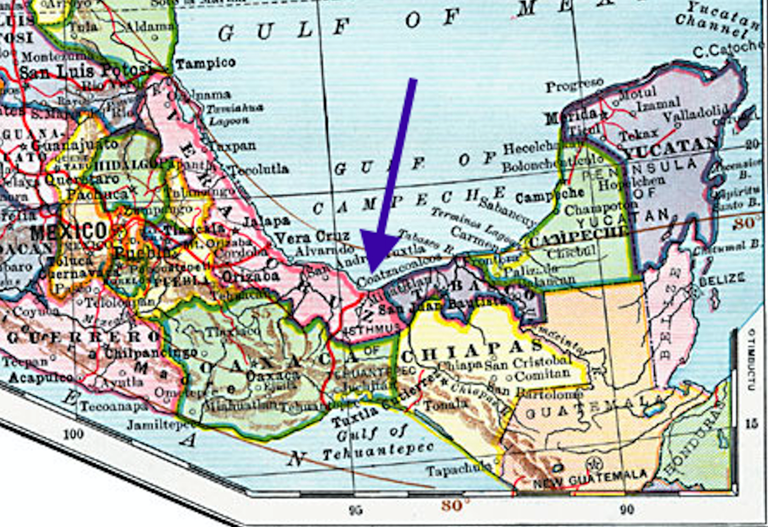
A 1902 map shows the area of Tehuantepec, and
labels it the Isthmus of Tehuantepec
In 1828, before the Book of Mormon was published, the word “neck” in relation to land was defined as: “A long narrow tract of land projecting from the main body, or a narrow tract connecting two larger tracts; as the neck of land between Boston and Roxbury.

In both photos the Red Arrow points to the narrow neck between Boston and
Roxbury to show what is meant by the definition of “Narrow Neck of Land”
It is about time we start realizing what Mormon tells us in the scriptural record how the geographical setting he describes fits together to allow us to see the correct and accurate design of the Land of Promise. We need to stop listening to people who claim they are "experts" oln a subject like this and study the scriptural record for ourselves and use our own common sense and the Spirit to understand what was intended when the record was written.


In Sorenson's book "Mormon's map", he actually starts by drawing an internal map based on the scriptures. He does not try to tie this to any modern map. His internal map appears to match the scriptures quite well, and interestingly, it also matches the south american model. It is only when he tries to tie it to central america that he decides to flip the directions and stray from his scripture based internal map. To justify this, he references that some other cultures use different ways to determine direction sometimes- but does not use any scriptures that I recall- to justify the change. I think because some descendants of Lehi went north in Hagoth's ships and settled central america and built buildings we can see today, it is easy to think that central america may be the book of mormon lands. But deeper study shows otherwise.
ReplyDeleteWell said, David. That is exactly right, and it is not just Sorenson, but all other Mesoamericanists tend to follow that example thought some disagree with the directional labeling of it
ReplyDelete