
The problem is, that most of these theorists consider it important because of its prominence in the geographical setting of the Land of Promise. While that is true, we also need to understand its importance to the Nephites and Lamanites, as well as the Jaredites before them—otherwise we may well choose an area for placement of the narrow neck that is not applicable to Mormon’s extensive descriptions of it and its purpose.
So before looking for a location of a narrow neck of land, let us consider its descriptions and, therefore, its requirements.

Mormon’s narrow neck is a small and
slender area of land between two much larger land masses, and would have been
distinctly visible to a man in 600 B.C.
Keeping in mind that Mormon, with his insert in Alma 22, is trying to describe the land and its relationship of one area to another when he tells us that this “small neck…was only the distance of a day and a half’s journey for a Nephite” (Alma 22:32). Consequently, the “very narrow” or “little width” would have been the distance a Nephite could cover in a day and a half as he journeyed across it—for this to be meaningful to his future reader, the Nephite would have to represent a normal man walking at a normal pace, not some athlete, special runner, or endurance person unidentified as such and unknown to his future reader.
At a minimum, then, the neck would have had to be at least 20-30 miles wide, figuring a normal journey of a normal man would cover less then 2 miles per hour for a day’s travel of 12 hours, and another 6 hours for half a day. The maximum might then be 25-35 miles. So any narrow neck would have to be somewhere in the area of about 20 to 35 miles across. We also need to understand that the Narrow Pass or Passage through the Narrow Neck of Land had to be much narrower in order for the serpents of the Jaredites to have “hedged up the way” (Ether 9:31,33).

The Narrow Neck of Land in the Land
of Promise as described by the scriptural record with a Narrow Pass through the
neck connecting the two larger lands
1. The entire Land of Promise must have been an island (2 Nephi 10:20), and divided into two large land masses (Alma 22:32-33), the Land Southward (Bountiful, Zarahemla, Nephi), and the Land Northward (Desolation, Cumorah and land of many waters), connected only by a narrow neck of land between them (Alma 22:32);
2. The Land of Promise and the Narrow Neck must be oriented in a north-south direction (Alma 22:27-32);
3. The Narrow Neck must be flanked by a west sea and an east sea (Alma 22:27,32-33; 50:34);
4. The combined land of Zarahemla and Nephi (Land Southward), must be completely surrounded by water except for the narrow neck of land;
5. The Narrow Neck must be located at a place where “the sea divides the land” (Ether 10:20);
6. It must be the only connection between the Land Southward and the land Northward (Alma 22;32;63:5);
7. It must be conceived as a distinct and significant narrowing of the terrain on both sides (compared to the lands beyond) by one standing in the area without aerial or satellite maps or views from space (at some point both shores would have to be viewed at the same time to see that it was, in fact, a narrow neck).
8. It must have a “narrow pass or passage” through it, that leads into the Land Northward (Alma 50:34; 52:9), and into the Land Southward (Mormon 2:29; 3:5);
9. It must be at a lower elevation than the higher land to the south (Mormon 4:1,19);
10. The city of Desolation must be located on the northern portion of the narrow neck (Mormon 3:5–7), since the Jaredites built a “great city” at the narrow neck (likely the same as the city of Desolation Ether 10:20);
11. The Narrow Pass or Passage through the Narrow Neck must be an area which would be easily fortified (Alma 52:9; Mormon 3:5–6);
12. The land to the south (Land Southward) was not inhabited by the Jaredites, but reserved for hunting—thus no Jaredite building remains should be found south of the narrow neck (Ether 10:21).
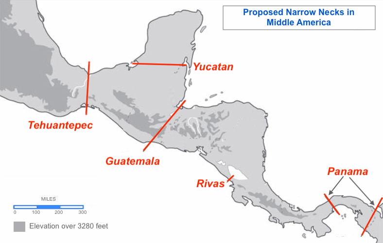
Various proposals for a narrow neck
of land by several theorists, including Sjodhal, Jakeman, Ferguson, Sorenson,
Palmer and Allen (Tehuantepec); Lowe, Christenen, Robinson, Qulter and Pate (Guatemala);
Warr (Rivas); Wilde, Dixon and Hobby (Panama). In addition, Holley, Curtis,
Gobble, May, Meldrum and Sudweeks consider the Niagara Peninsula in North
America to be the narrow neck

The Mesoamericanists general view of the Narrow Neck of Land being the
140-mile wide Isthmus of Tehuantepec
In fact, before the Lamanites battled their way toward the north in the last century B.C., and were eventually defeated and pushed back into their own lands, most of the Nephite concerns were from dissenters, like Morianton, trying to gain the Land Northward as a base of operations, and in some way enter into a liaison with the Lamanites in order to have a two-front war against the Nephites (Alma 50:32).
The point is, the Nephites fully understood the value of their geographical positioning and that of the Lamanites, keeping them in the south, which they did until the last battles began in the borders of Zarahemla, by the Waters of Sidon in about 322 A.D. (Mormon 1:10).
In fact, Mormon, in writing this final work, remarked about all of this since he had lived through the loss of all the Land Southward to the Lamanites and fully understood the importance of Nephite history having controlled all this area and keeping the Lamanites to the south of their lands.
Thus, any Land of Promise must show that the Lamanites, in the Land of Nephi, were always to the south of the Land of Zarahemla, on the south side of the Narrow Strip of Wilderness, which had always separated them once Mosiah fled the city of Nephi and discovered Zarahemla. Unfortunately, many theorists maps and land layouts do not show this vital point.
(See the next post regarding “How Important Was the Narrow Pass or Passage? Part II Mesoamerica”)


No comments:
Post a Comment