The Lima Culture—Blue Dots: The original settlements of the Lima;
Yellow Dots: Eventual spreading into the Rimac Valley; Green Dot: the Lima Administrative,
economical and religious activities center, which contained impressive huge
monuments, numerous pyramids, palaces, temples, administrative centers, an
ancient wall, roads, residential areas, water reservoirs and irrigation
channels (today in the Parque de las Leyendas in Lima's district San Miguel)—in
the past, the area of Zarahemla
The area containing the city was occupied from 600 BC until the Incan period around 1532 AD, when it was deserted after the Spanish conquest. What remains now, was formally preserved in 1960 and made a part of Parque Leyendas in 1964.
In addition, these early Lima Culture engineers developed one of the finest network of irrigation channels ever seen anciently, and the oldest in the Americas. A team of researchers working in the Andean foothills of Peru has unearthed solid evidence of canals confirmed to be at least 5,400 years old. The find is the oldest of its kind anywhere in South America, ranging from 2.5 miles to six miles in length and designed to slope downwards, relying on gravity to send water from an upper stream to the crop fields below, with each irrigation system having its own specific hydrology or water balance.
An irrigation channel made of rough stones or river rock with a terraced
bank and secondary rock walls to eliminate erosion
The evidence shows an early cognizance of flow rates, canal cross-section technology, and slope dependence in surveying and installing small gravity contour canals. There is no evidence in the study area of a centralized bureaucracy to manage the supply of water to the canals and of mechanical devices to control flow rates.
These findings also suggest agricultural produce was as important as marine foods in the rise of early civilization in the coast of Peru between 5,500 and 4,000 years ago. In some cases, such as with Huatica and Surco, the latter one of the most ambitious of the canals, which supplied water to the many chacras or fields lying between the Rimac River and Armatambo on the ancient road between Maranga and Pachacamac, were in fact pre-hispanic irrigation canals. It was only the passage of time had conferred irregular features on them becasue native trees such as the guarango would root themselves in the banks to lend these canals the aura of authentic rivers.
Somewhere around 100 AD, there was a strong rebuilding effort in the
various Lima Culture pyramids and settlement complexes. The area of Lima in the
Rimac and Lurin Valleys corresponds nicely with the Greater Zarahemla center
and Nephite capitol
Currently the Pucllana Archeological Zone spreads over 37 acres and is divided into two well-defined sections. One is of pyramidal structure, in a terrace formation, which is over 75-feet high and constitutes the ceremonial sector. There, they performed activities related to the religious cults to worship their gods.
The administrative center was located on the other section—the area of public squares and ramps. It is formed by interconnected precincts with benches, courtyards and passageways, where architectural evidences show that walls were plastered and painted in yellow ocher. This is where public and political matters, trade activities, as well as storage, ceremonies and summons used to take place.
What did these ancient Peruvians trade? What did they store? Without doubt it was their elegant ceramics of symbolic character, representing figures of interlaced snakes or fish shapes in red, black and white. Also knitted fabrics made out of cotton and Peruvian camel (llama and alpaca) wool, simple but well manufactured, in white, brown and beige colors. Craftsmen would also contribute with basket making and fishing nets, but mainly they traded and stored the food and agricultural products grown in the valley.
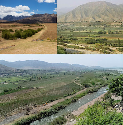
The Lima Valley, a flat basin between
hills and mountains
The name of the huaca comes from the Quechua, “puclla,” meaning “game,” which in its entirety can be translated as “a place for ritual games.” It served as an important ceremonial and administrative center for the advancement of the Lima Culture, a society which developed in the Peruvian Central Coast around 100 AD. With the intended purpose of having the elite clergymen (whom politically governed several valleys in the area) express their complete religious power and ability to control the use of all the natural water resources (saltwater and freshwater) of the zone, a Great Pyramid was constructed in the Huaca.
The outer wall of Pucllana, at one
time plastered and painted yellow ochre
Now the city of Zarahemla, the single most prominent city mentioned in the entire scriptural record throughout the Land of Promise, was burned during the great calamities that struck at the time of the crucifixion (3 Nephi 8:8,24), which was at the time that mountains collapsed into valleys and valleys rose to become tall mountains, “whose height was great” (Helaman 14:23).
Peace quickly spread throughout the land over the next ten years and more, as “the Lord did prosper them exceedingly in the land; yea, insomuch that they did build cities again where there had been cities burned. Yea, even that great city Zarahemla did they cause to be built again” (4 Nephi 1:7). Thi continued over the next two hundred years, with the Nephites all at peace with one another and rebuilding their nation; they multiplied immensely, and had become exceedingly rich (4 Nephi 1:23).
Now, with wealth, peace and time (two generations from the time of Christ had passed away), and with a desire to build up their land and country once again over two hundred years, we can understand that the rebuilding of Zarahemla, the nation’s capitol, would have included larger complexes of buildings and large, impressive buildings.
The results of which have been found and uncovered in the area of Pachacamac northward into the Lima and Chillon basins or valleys, at about this same time by the people of antiquity.


No comments:
Post a Comment