
He goes on to quote a statement Governor DeWitt Clinton made before the New York Historical Society in 1831: “I have seen several of these works in the western part of this state. There is a large one in the town of Onondaga, one in Pompey, and another in Manlius; one in Camillus, eight miles from Auburn: one in Scipio, six miles, another one mile, and one about half a mile from that village. Between the Seneca and Cayuga Lakes there are several—three within a few miles of each other. Near the village of Canandaigua there are three. In a word, they are scattered all over that county.”
On the surface, the blog’s author appears to be on to something; however, when one digs deeper into the actual history of this area, a different story appears. So let’s first take Onondaga (from an Iroquois word “onõtáge,“ meaning “on top of the hill,” which was the name of their principal village). The name Onondaga means “people of the hill.”
Jean de Lamberville, a French Jesuit priest to the Onandagas, and highly respected by chief Garakontie because of his medical knowledge and treatments, wrote that main Onondaga village was situated along the east bank of the Butternut Creek about a mile south of present day Jamesville, in the valley now flooded by Jamesville Reservoir.”

33-mile
long Butternut Creek is a stream that runs from just south of the marshy waters
of Apulia Station, through Jamesville, intersects the old Erie Canal near
DeWitt, and continues north from Onondage and joins Limestone Creek near Minoa east
of Syracuse and continues north through Bridgeport and into Lake Oneida
Ephraim Webster, the second settler of the original town and the first of the Indian traders to reach the area after the Revolutionary War, opened a trading post along Onondaga Creek, married an Indian woman and had s son: Arotarhos (Harry Webster).
The first settlement of the Onondagas, who claim this site of Teuaheughwa, afterwards called Onondaga Hollow—founded by Major Asa Danforth, the pioneer of the town and founder of Onondaga civilization under Chief Cawhicdota and Tawhisquanta, the former calling Danforth Hatecolhotwas“ (he plows the ground”), was one of the earliest points of settlement, prior to the era of the Onondaga establishing their council fire there.

Oren
Lyons, Faithkeeper of the Turtle Clan, Onondaga Council of Chiefs of the
Haudenosaunee, holding George Washington’s famous Wampum belt
As early as 1795 William Laird became the first settler there, on lot 114, where he also opened a tavern. Jabez Webb and Nehemiah Earll located on the Hill in 1796, the latter building a large dwelling that was afterward occupied by William P. Walker, a lawyer, and more recently by Oscar Britton, who became the first postmaster in 1800. His brother, Jones, was a merchant in the old stone store there, and served as county sheriff, canal commissioner and State senator—both were very prominent in the early life of the town as well as the town of Skaneateles. In 1798, Ephraim Webster was the first elected supervisor at the first election, and in 1815, Onondaga had its first Academy.
It should be noted that though the history of this area is extremely well defined, (contained in the Onondaga’s Centennial records in the Boston History Co., 1896, Vol I, pp836-866), there is not a single mention of any former site of the area other than a square fort of some type. Nor is there any suggestion as to when this fort had been standing except in the early days of the Onondaga Indian settlement. In addition, the township had no villages within it, tough having 13 hamlets, 9 populated places, 1 reservation, 1 location and 1 valley.
Unlike most towns in the county, the town of Onondaga formed no part of the two million acre of the great Military Tract, which was 28 townships of land set aside to compensate New York’s soldiers after their participation in the Revolutionary War, covering the counties of Cayuga, Cortland, Onondaga, and Seneca as well as parts of Oswego, Tompkins, Schuyler and Wayne. The Tract did, however, cover the major portion of the original Onondaga and Salt Springs Reservation.
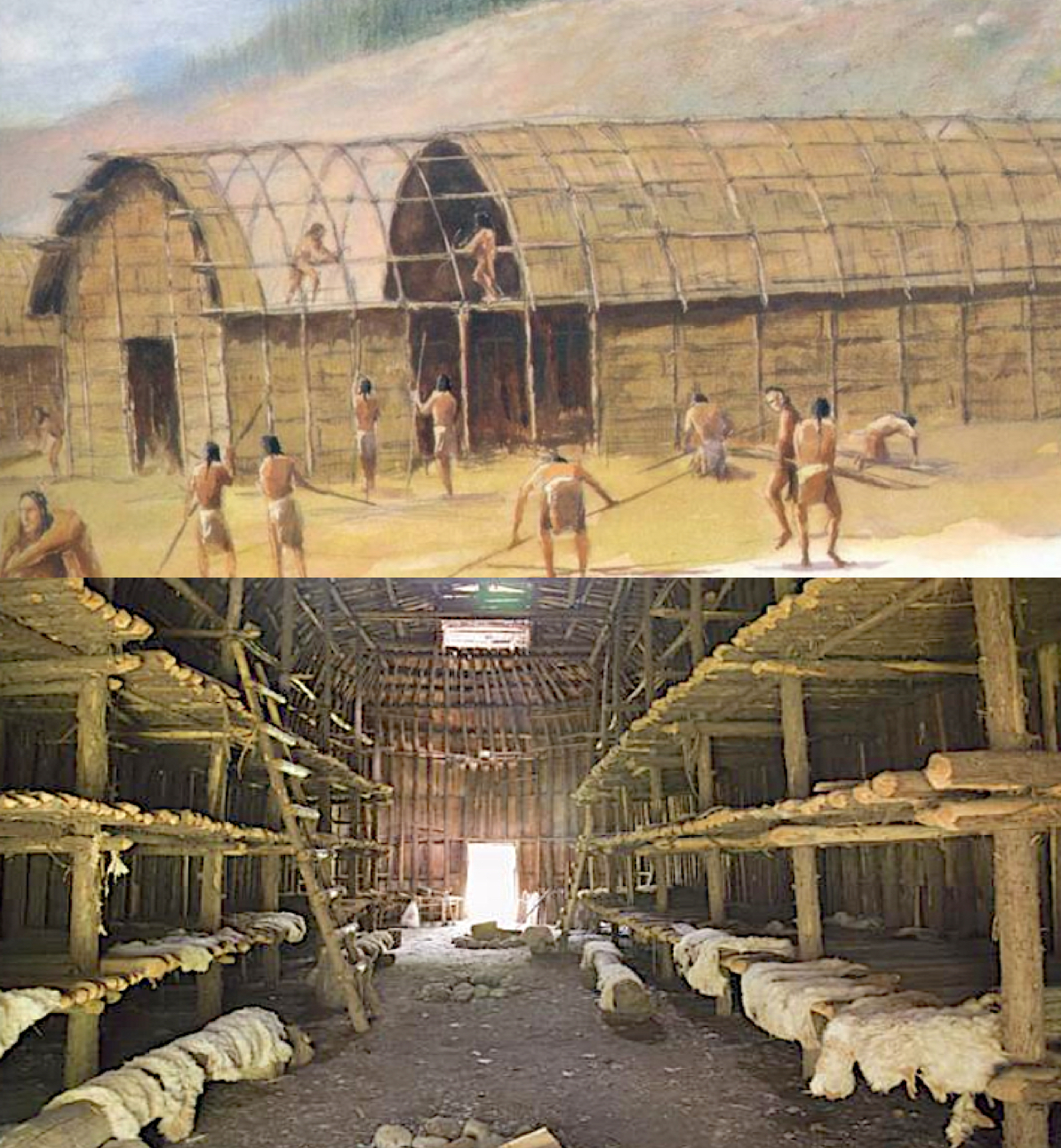
Iroquois “long house” that houses twenty or more families and considered the main structures of the Iroquois people
Originally, the Onondaga town site guarded the western entrance to the "long house" of the Iroquois, which long houses were built to house 20 or more families, and which once included the site of their principal village. It should also be noted that the Iroquois Indian tribe was actually a confederacy of six Indian nations: Mohawk, Oneida, Onondaga, Cayuga, Seneca, and Tuscarora. They were a very powerful and prominent Indian tribe, and though called Iroquois by their neighbors, the Algonkian people, and European settlers, they called themselves “Haudenosaunee,” which meant “people who live in the extended longhouses.”
The Iroquois lived in a type of dwelling known as a longhouse. A longhouse is a long, narrow single room often regarded as the earliest form of a permanent structure. While the longhouse may have reached lengths over 300 feet, they were generally never wider than 16 to 23 feet. They were quite dark inside, having no windows, though there were holes in the high roof to let out fire pit smoke, but they provided very little natural light. There were doors at each end that were usually covered with animal skins during the winters to keep out the cold. Each of the 20 or more families that occupied the longhouse would occupy a booth on either side of the hallway, which held a wooden platform for sleeping.
We might want to keep in mind that this was the construction of what was considered the most advanced peoples in ancient North America.

Lists of hundreds of writings made by early settlers of Onondaga, New York
As to this square fort the author of the blog claims was built during Nephite times, we need turn to the history surrounding this.
(See the next post, “Have They Found Where Battles Were Fought Around Cumorah? – Part II,” for more on the so-called Nephite forts built in North America around the Great Lakes region)


No comments:
Post a Comment