It is of interest that the East Sea, Sea East, East Seashore are mentioned 19 times in the Book of Mormon before the crucifixion, but not once after the destruction and after “the face of the whole earth became deformed (3 Nephi 8:17). At that time, within a three hour period, mountains rose out of valleys. As Samuel the Lamanite said it, “there shall be many places which are now called valleys which shall become mountains, whose height is great” (Helaman 14:23)
Mountains rose to great heights and could be seen from great distances
“The mountains mentioned above can be seen from great distances, several mountain peaks from one place” (“About other Cordillera Blanca, the White Mountain Range,” Cordillera Blanca, Go2dAndes Adventure Travel, December 2020).
The Andes are very narrow in most places and the average width is 124 miles. Aconcagua, the highest peak in the Andes, is 22,841 feet, and many of the peaks are active volcanoes. The mountain range is part of seven countries: Peru, Ecuador, Chile, Bolivia, Argentina, Colombia, and Venezuela. The mountain form a massive barrier between the eastern Pacific Ocean and the rest of the continent of South America. This barrier impacts the climate of South America, with the northern part of the Andes typically rainy and warm. The west side of the central Andes is extremely dry and includes the Atacama Desert in northern Chile; the eastern portion of the central Andes is much wetter. In the south, the western side of the Andes tends to be wet, while the eastern plains are in rain shadow and tend to be very dry. Many of the peaks in the Andes receive heavy snowfall and contain glaciers.
Mountains, whose height is great
For tall mountains whose height is great, the Andes Mountains of South America is the only mountain range in the Western Hemisphere that meets this description. The Andes run for 4,660 miles, with 220 mountains over 18,000 feet. Obviously, it was a range that could be seen throughout an area the size of the Land of Promise. That is, such a mountain range meets the requirements of Samuel the Lamanite’s description.
Not only were the Andes a mountain range “whose height is great,” but also the range covered such a large area, it meets Samuel the Lamanite’s specific message as to why the mountains fell, and others rose out of valleys to become tall mountains, and that was “that they might believe that these signs and these wonders should come to pass upon all the face of this land, to the intent that there should be no cause for unbelief among the children of men” (Helaman 14:28).
Now for such an event to meet that rquirement, i.e., “upon all the face of the land,” and “that there should be no cause for unbelief,” because all witnessed the events Samuel described, these mountains could not be in some corner of the land where only a small percentage of the Nephites saw the event.
Obviously, the Andes Mountains were tall enough and covered such a large area, that all the Nephites would see the rising of these mountains. No other mountain range could qualify to accomplish such an important view to all the people.
Mountains in Guatemala Mesoamerica
In comparison, Mesoamerica is quite different. As an example, Guatemala has 70 miles of mountains with the highest peak at 3,688-feet, and in southern Mexico (Sierra Madre Occidental the elevation of 10,863 feet; with the Volcan Tajkumulco peak in San Marcos in western Guatemala at 13,786 feet. Sierra Madre Mountains is 5,850 feet.
Obviously, these mountains and their height and lack of continued mountains would not match the scriptural account as given above; And the Heartland and Great Lakes areas of North America simply do not have mountain ranges at all unless one extends the land areas—which the theorists do not—all the way to the east coast where low mountains run north and south with Mount Mitchell in North Carolina the tallest at 6,684 feet.
Regarding the land itself, the high elevations in the Dry Andes cause all precipitation to fall as snow. Cold powder snow is blown from the mountain summits. Glacierets in the Desert Andes may be found only on the leeward side of summits, in more or less well-pronounced cirques, which are half-open steep-sided hollows at the head of a valley or on a mountainside, formed by glacial erosion—which eroded some of the cirques during the "Ice Age".” In the Desert Andes, precipitation is accompanied during local storms by a great deal of lightning. By comparison, to the south in the Chilean Central Valley and in Patagonia lightning is almost unknown. The transient snowline may, therefore, differ from one mountain to another.
Large glaciers of the Central Andes are found at the heads of high valleys. Glaciers are most commonly oriented to the southeast and their elevation increases from west to east.Thus, the concept of a snowline as a function of elevation, or the lower limit of glacierization, cannot be applied in the Dry Andes. Only a glaciation level may be defined (elevation of the lowest summits that have permanent snow patches), and even this concept must be handled with care, given the greater importance of local topography. For instance, the young Volcán Maipo at 17,355 feet, has only a few permanent snow patches in gullies, although the glaciation level is about 14,763 feet in this area.
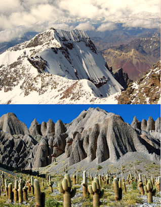
Eastern side of the Andes Mountain (Top) Snow covered heights, (Bottom) the lower mountains with Cardon cactus scattered about
The mountains on the eastern side of the Andes with giant Cardon cactus has eroded clay soil. This soil is young clastic wealdy consolidated and unconsolidated sediments made up of sands, sandstones, clays, clay-shales, gravels, and conglomerates.
In Peru, the Nevado Kuajadajanka in the Cordillera Raura of the Andes, rises to 17,800 feet. The source of the Amazon River lies on the east side of the Cordillera Raura, as determined by the Royal Geographical Society in 1950: the tiny glacial lake Laguna Niñococha feeds Rio Lauricocha, then Rio Marañon, then the Amazon.
On the east side of the Andes the Peruvian Amazonia is the area of the Amazon rainforest included within the country of Peru, from east of the Andes to the borders with Ecuador, Colombia, Brazil and Bolivia. This region comprises 60% of the country of Peru and is marked by a large degree of biodiversity. Peru has the second-largest portion of the Amazon rainforest after the Brazilian Amazon.
This is an area where once the Atlantic Ocean flowed, and as Darwin, after discovering a bed of fossil seashells at 12,000 feet in the Andes Mountains, put it: “I cannot express the delight which I felt at such a famous winding up of all my geology in South America. I literally could hardly sleep at nights for thinking over my day’s work.” He also found a forest of petrified pine trees surrounded by marine rock deposits, convincing him that these trees had once stood beside the Atlantic, 700 miles away, of which he wrote: “Since leaving England I have never made so successful a journey” (Toby Green, “Saddled with Darwin,” Peaks of the Chilean Andes, Faber Finds, 2009).
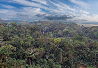
Dense rainforest in eastern Peru, where once the Atlantic Ocean reached and its waves washed up on the shores at the base of the distant east coast of Peru
Most Peruvian territory is covered by dense forests on the east side of the Andes, yet only 5% of Peruvians live in this area. Much of the Peruvian territory is covered by the Amazon rainforest, more than in any other country, which is traditionally divided into two distinct ecoregions:
1. The lowland jungle, also known as the Amazonian rainforest or Amazon basin, is 2.5 million square miles. It is the largest tropical forest on Earth (about the size of the 48 contiguous United States) with the highest density of plant and animal species anywhere on Earth. It also contains the largest number of freshwater fish species in the world, and represents over half of the world’s remaining rainforest. Its moist, tropical vegetation stretches from the Atlantic Ocean in the east to the Andes Mountains in the west, and is the largest ecoregion of Peru, standing between 265 and 3,280 feet above sea level.
The lowland jungle of the Amazon rainforest. Note how much of the area is underwater or surface water and the lily pads floating on it
It has very warm weather with an average temperature of 82°F, high relative humidity (over 75%) and yearly rainfall of approximately 100 inches (by comparison, the annual rainfall of Utah is from less than 5 inches in portions of the Great Salt Lake Desert to more than 20 inches in some portions of the Wasatch Mountains). Because of high temperatures and high rainfall, its soils are poor with few nutrients, and very heterogeneous, as almost all have river origins.
2. The highland jungle (Selva Alta) is also called Rupa Rupa region, the Andean high jungle, ceja de selva, the latter being the eastern Andean montane of the Central Andean highlands and coast. This ecoregion forest extends into the eastern foothills of the Andes, between 3,280 and 12,467 feet above sea level. This region was well connected to events happening in the Central Andes during the Initial Period of development in the type if societies that developed in the Peruvian region with relationship to the Central Andean coast and highlands. This area developed in settlement long before the Inca.
The eastern slopes of the Andes are home to a great variety of fauna and flora because of the different altitudes and climates within the region. Temperatures are warm in the lowlands and cooler in higher altitudes. There are many endemic fauna in the western Amazon because of the isolation caused by the rugged terrain of the area (Javier Pulgar Vidal, Las ocho regiones naturales del Perú, Boletín del Museo de historia natural, vol.17, Lima, 1941, pp145-161).
These are the mountains that came up, whose height is great, that once was level ground along the east coast of the island that became the continent of South America at the time of the crucifixion. It also shows that the mountains came up, pushing back the East Sea into its present position, leaving the huge Amazon Basin barely above sea level over a two million square mile range.


No comments:
Post a Comment