
Continuing with the 12 Landforms of the Land of Promise and how Mesoamerican, Heartland and Great Lakes theories measure up to Mormon and other prophets of the scriptural record have described them). The first five points and part of the 6th were covered in the previous posts.
Repeating the final comment from the last post: “To make sure the Lamanites in the Land of Nephi also understood the events and rise of tall mountains, when Samuel the Lamanite was driven out of the Land of Zarahemla, he “did flee out of their lands, yea, even unto his own country, and began to preach and to prophesy among his own people” (Helaman 16:7, emphasis added). Thus, both the Nephites and the Lamanites knew of the coming events of mountains collapsing and others rising high upon the land.”
Following is the continuation of item #6 regarding very tall mountains in the Land of Promise, begun in the previous post and continued here:
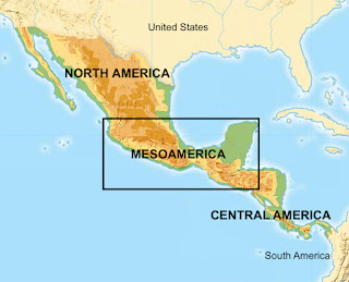
North America, Mesoamerica, Central America, and South America
• Mesoamerica: Meaning “Middle America,” is a sub-area of Central America, and beyond the western limit of Mesoamerica is Central and Northern Mexico (called Aridoamerica and technically part of North America); beyond the eastern end of Mesoamerica is an area known as Centroamerica, which occupies the Pacific coasts of El Salvador, Honduras, Nicaragua, and the Nicoya Peninsula in Cost Rica. In between is the Land of Promise claimed by Mesoamerican theorists.
The tallest mountain in this Mesoamerica is Volcan Tajumulco, a dormant volcano located in western Guatemala, near the Mexican border. Its peak elevation is 13,845 feet, and is the highest point in Mesoamerica. The Sierra Madre mountain range, which consists of a number of smaller ranges—such as the Maya Mountains reaching a height of 3,688 feet at Doyel’s Delight—runs from Northern Mesoamerica south and beyond Mesoamerica into Costa Rica (Olivier Chassot, et al, “Sustainable Mountain Development in Meso America,” Regional report for Mesoamerica, Latin American School for Protected Areas, University for International Cooperation, Tropical Science Center, San José, Costa Rica, May 2012).
The region is generally divided into four loosely defined zones: the southern Maya highlands, the southern and central Maya lowlands, the northern Maya lowlands, and the Petén Basin, primarily located in northern Guatemala and into Campeche state in southeastern Mexico.
• Heartland: This area is made up of the Great Plains, an area flat through 19 states, with Eagle Mountain, above Lake Superior in Minnesota, the highest natural point at 2,301 feet.

The Great Lakes location is between the Appalachian Mountains and the Great Lakes and some models swings around below Lake Erie and up to Lake Huron
• Great Lakes: This Land of Promise lies between the Appalachian Mountains and the lakes, where Mount Mitchell in western North Carolina, beyond the Great Lakes Land of Promise, sits at 6,684 feet and is the highest point east of the Mississippi River.
• Andean South America: By comparison, Ecuador in the northwestern part of South America, and the home to 1,289 named mountains, the highest and most prominent of which is Chimborazo at 20,564 feet. Peru—which name is synonymous with mountains that are so pervasive it is almost impossible to imagine a landscape without soaring peaks looming in the horizon (Only in the Amazon plain and some areas in the arid coastal desert does the land flatten out)—has the rugged Andes Mountains that cover almost 40% of the country, with mountains of significant elevation everywhere in the land. In fact, Peru has some of the highest concentrations of peaks over 16,500 feet in the entire world! In addition, there are 12 or so mountains above 20,000 feet, including many dormant stratovolcanoes. Mount Huascarán, the tallest mountain and towering over the surrounding landscape in the Cordillera Blanca, rises to 22,205 feet, with the second highest mountain, Nevado Yerupajá at 21,709 feet, and located in the the Cordillera Huayhuash range.
Chile has a high-elevation topography overall with an average elevation of 6,140 feet above sea level. The Andes Mountains comprise much of the land in the east, with peaks averaging at heights of 15,000 feet above sea level
7. “A major river whose head or source was high in the mountains between the Land of Nephi and the Land of Zarahemla (Alma 22:27)”:

The Land of Promise showing the Narrow Strip of Wilderness separating the Land of Zarahemla and the Land of Nephi, or the Nephite lands from the Lamanite lands
The head or source of this river was south of the Land of Zarahemla within the Narrow Strip of Wilderness (Alma 2:27). Now this wilderness was on the north of the Land of Nephi and to the south of the Land of Zarahemla, thus Mormon wrote of the river: “[it was] round about on the borders of the seashore, and the borders of the wilderness which was on the north by the land of Zarahemla, through the borders of Manti, by the head of the river Sidon, running from the east towards the west” (Alma 22:27, emphasis added). That is, the head of the River Sidon was within the Narrow Strip of Wilderness—which ran from the east to the west—on the north of this wilderness bordering on the Land of Zarahemla.
In addition, the River Sidon ran past the Land of Zarahemla. Mormon states this in: “which was east of the river Sidon, which ran by the land of Zarahemla” (Alma 2:15, emphasis added). Now, with the head or source of the River Sidon in the Narrow Strip of Wilderness to the south of Zarahemla, and the river flowing past the land of Zarahemla to the north, the river obviously flows from south to north. That is, the river flowed from its head or source in the south toward the Land of Zarahemla and past that land, obviously meaning, that the river flowed from the south (its head in the Narrow Strip between Zarahemla and Nephi) to the north.
There is simply no way to interpret this differently—the River Sidon ran from the south to the north, which eliminates any theory based on a flow from north to south for the Sidon.
• Mesoamerica: There are two rivers that run north to south on their map of the Land of Promise; however, since they have skewed their dimensions with a their land to the east and west, then cannot then say “except for these two rivers.” If the rivers are correct, then the rest of their directions are incorrect. If their overall directions are correct, then the rivers cannot be correct.
• Heartland: These theorists use the Mississippi River as their Sidon River from the confluence of the Mississippi and the Ohio rivers. They mark this spot as the “head or source” of their Sidon River; however, the Mississippi River is so named to the north and to the south of this confluence, consequently, the confluence is the mouth (or end) of the Ohio River, not the beginning of the Mississippi.

Buffalo Creek that ran east to west in western New York
• Great Lakes: These theorists clam that Buffalo Creek is their Sidon River; however, while this creek flows south to north at the last few miles of its lengthy course, about 90% of this creek flows from east to west. In addition, as it passes through their Land Southward, it is extremely shallow in places, and no bodies could have floated to the sea along its course.
The city of Buffalo (these animals did not inhabit this area) was originally named Buffalo Creek after the river that ran past the area—a name that first appeared in print as part of the boundary description in the 1784 Treaty of Fort Stanwix between the fledgling United States and the Six Nation Confederacy.

Three locations along Buffalo Creek. Note the shallowness of the creek in places that would not allow bodies to float to the Sea as Mormon describes
“And thus he cleared the ground, or rather the bank, which was on the west of the river Sidon, throwing the bodies of the Lamanites who had been slain into the waters of Sidon, that thereby his people might have room to cross and contend with the Lamanites and the Amlicites on the west side of the river Sidon” (Alma 2:34, emphasis added); “And now as many of the Lamanites and the Amlicites who had been slain upon the bank of the river Sidon were cast into the waters of Sidon; and behold their bones are in the depths of the sea, and they are many” (Alma 3:3, emphasis added)
And it came to pass that they did cast their dead into the waters of Sidon, and they have gone forth and are buried in the depths of the sea.” (Alma 44:22, emphasis added).
This would not have occurred in Buffalo Creek because of its many shallow areas where nothing larger than small branches pass. In fact, Buffalo Creek west of its confluence with Cazenovia Creek is known today as Buffalo River as it run to the west where it was dredged and widened as part of the river at the end of the Erie Canal where it opened into Lake Erie.
Originally, however, the entire length of the Buffalo River/Creek was known as Buffalo Creek, and was the original name of the city of Buffalo, named after the creek that ran by the town.t. m
Obviously, there are no significant mountains in either the Great Lakes or Heartland theory models, with Mt. Mitchell in North Carolina the highest point east of the Rocky Mountains, though not within the Land of Promise of either theory.
(See the next post for the continuation of these 12 Landforms and how Mesoamerican, Heartland and Great Lakes theories measure up to how Mormon and other prophets of the scriptural record have described them)


No comments:
Post a Comment