
It has been difficult for most people knowing the scriptural record to consider South America as the Land of Promise, believing the erroneous and nefarious concept of Uniformitarianism, i.e., changes occurring over millions of years, rather than cataclysmic events, which can change suddenly.
After all, as geologists know, that in weakened places the magma can rise quickly, which is how the many volcanos of the cordilleras in Andean South America came into existence—there have not only been disastrous eruptions in recent times, but very fast landform changes. What the effect these changes have had on rivers over time is unknown, especially dating back into pre-crucifixion times in the far away Western Hemisphere (Christoph Stadel, The Andes: A Geographical Portrait, Springer International Publishing, Switzerland, 2015, p35).
As an example, today the Apurímac River begins at 18,363 feet in the snow-fed mountains of Mismi in the western cordillera of the Arequipa Province, which has been determined to be the most distant source of the Amazon. Nevado Mismi is 10 miles northward from Chivay, 100 miles west of Lake Titicaca, 435 miles southeast of Lima, and 195 miles south of Cuzco—it is one of the highest points of Colca Canyon.

The Apurímac River, “Main River” of Peru
Apurímac is taken from the Quechua apu, meaning “divinity,” and rimaq, meaning “oracle or talker.” Thus, the “Talking River,” or more accurately, “The Divine Talking River,” or “The Divine [God] Talks”—and of the latter, over time this became “the gentleman talks.”
This overall name was given because the sound of the river through much of its course is very loud, especially as it roars along, first north-easterly, then north-westerly, past Cuzco to the mouth of the Perené tributary. Anciently, it was believed that God spoke in the loud roar of the river as it passed.
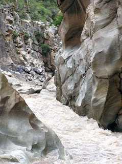
Narrow Gorge of the Apurímac River Canyon
The course through narrow gorges with depths of up to 9,850 feet, nearly twice as deep as the Grand Canyon, with its course interrupted by falls and rapids. According to the Inca Garcilaso de la Vega, the Apurímac River was also called Capac Mayu, which means “Main River,” in order to highlight its importance over the rivers or streams—a similar tendency of Mormon highlighting only the River Sidon.
This tendency is also seen in the writing of the Spanish chronicler and conquistador Pedro Pizarro, regarding the Apurímac River, and the place this river occupied in the Andean worldview—much like Mormon’s placement of the Sidon River.
Pizarro wrote an extensive chronicle under the title Relación del descubrimiento y conquista de los reinos del Perú (“Relation of the discovery and conquest of the kingdoms of Peru”), that he finished in 1571, in which he stressed the importance of the river—again a similar tendency of Mormon highlighting only the River Sidon.
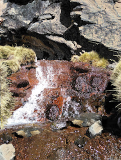
The meager beginning of the Apurímac River and, ultimately the Amazon
Mt. Mismi is 18,363 feet high, beginning with the small brook called the Carhuasanta, which is considered the source of the Amazon River; however, the source of the river changes continuously over time because of shifts of the weather and its impact on the countless micro-climates of the region.
In the wet season the mountains and altiplano (Andean Plateaus) are covered in snow; in the dry season they resemble a desert. The same might be said of the source of the river between pre-crucifixion and post-crucifixion times, thus a current map is no guarantee a river or mountain range in the Land of Promise existed in that format before the crucifixion.
Owing to its lengthy Andean tributaries, the Apurímac River is currently the farthermost source of the Amazon River, that in its current format, the small river Carhuasanta joins with the Quebrada Apacheta, becoming the Rio Lloqueta that eventually joins with three other rivers near the small mining town of Caylloma, which lies near the junction of these four rivers seven miles away that form the Apurímac River. The river has several more name changes before it becomes the Apurímac River—from Caylloma, it flows first north-easterly, then north-westerly past Cuzco to the mouth of the Perené tributary, thence east and north to its junction with the Ucayali.

The Apurímac Ucayali, Ence rivers flow south to north through the entire area of the Land of Promise in Andean South America—it turns eastward at Iquitos, which would have been the coast of the Sea East
It is known as the Apurímac only down to the mouth of the Mantaro tributary 1325 feet, having dropped several thousand feet. From there it flowed to the mouth of the Perené (984 feet) to where it is known as the Ené, and from that point to its junction with the Ucayali (859 feet) as the Tambo.
Thus, the river flows from south to north until it joins the Amazon, the longest and largest river on the planet based upon the speed of its flow—certainly a requirement to send thousands of dead bodies all the way to the sea. In fact, of the six attempts so far to travel the Apurímac in its full length by three different types of rafts: oar boats, paddle boats, and inflatable kayaks (“duckies”)—only two have been successful
The valley of Apurímac, one of the three most important valleys in Peru (Hemisphere (Christoph Stadel, The Andes: A Geographical Portrait, Springer International Publishing, Geography, Switzerland, 2015, p7). It starts near the town of Pichigua in Peru, 160 miles due south of Cuzco and the Apurímac canyon in Checa, forming a rugged and extensive territory clear to the Pachachaca River, 145 miles due east of Cuzco, 10 miles west of Abancay—placing this rugged, elongated and narrow steephead valley or canyon with steep cliffs between mountains—in Mormon’s location—in the Narrow Strip of Wilderness between the city of Nephi (Cuzco) and the city of Zarahemla (Lima/Pachacamac).
This rugged and difficult configuration has different entrances and exits, all formed by the drains of the lakes that make interconnecting channels forming valleys, platforms and narrow spurs that end on steep slopes and fast and stormy waterfalls over the river.
Even today, this valley of Apurímac in the narrow strip with its constricted and reduced places is not suitable for population settlements—they are therefore suitable niches only for shelters, temporary hiding places and rugged and difficult escapes to the other side of the mountain range.
The maximum altitude of the populated territory reaches 11,811 feet and drops over 7,000 feet to its lowest point of 4593 feet, at the mouth of the Pachachaca River. This area provides three types of climates: puna, inter-Andean valley and wooded mountain. The mountains that are located to the west of the river exceed 13,123 feet, to the east of the valley is the Vilcaconga mountain range.

The Vilcabamba Mountain Range that would have been in the Narrow Strip of Wilderness certainly not conducive to settlement in Nephite times or today
It is unknown how these rivers and mountains were configured prior to the crucifixion, when mountains became valleys, and other valleys became mountains “whose height is great” (Helaman 14:23). Obviously, some changes were inevitable because when mountains—which are where river sources are located—change, the source of rivers changes, and likely a portion of their course is altered or disappears. Such might well have been the case width the Apurímac River, with its course ending in the new mountains rising to the northwest of Cuzco in the Abancay region.


No comments:
Post a Comment