

While this view was held by most members and leaders alike, in time there were those who began reading the descriptive geographical parts of the Book and realized that the Land of Promise could not be as large as a continent, or anywhere near that size. This led to what has been labeled the Limited Geography Theory, and out of this grew a smaller view, and a flurry of beliefs resulting in a map that showed 1) an hourglass shape of the Land of Promise, and 2) a generic location that did not try to pinpoint an actual physical land mass.

However, as the archaeology department and later the anthropology department were introduced into BYU, and grew in size and importance, the term “Limited Geography Theory” took on a life of its own and settled around the ancient ruins found in Mesoamerica. This knowledge and understanding first emerged as early as 1841 as a result of the book Incidents of Travel in Central America, by John Lloyd Stephens, which a copy found its way into the hands of Joseph Smith.

Since these ruins seemed to verify a Nephite presence in the Americas, it was highly touted by early Church leaders, including Joseph Smith, who suggested that Lehi must have landed somewhere south of the Isthmus of Darien (Panama).
However, when looking at a map of this area, it was obvious that Mesoamerica (Guatemala, southern Mexico, Yucatan, Belize and western Honduras) were not situated in a vertical landmass that ran north to south, but in a horizontal landmass that ran east to west.

However, this problem was pretty much ignored—especially by anthropologist John L. Sorenson, head of the anthropology department at BYU. He wrote a book of his ideas in 1985 entitled An Ancient American Setting for the Book of Mormon, in which he centered the Land of Promise in Mesoamerica. In a rather duplicitous manner, he began his book with the first three drawings Sorenson in his book showing a vertical hourglass shape, which was the design of the Land of Promise (see above map) previously accepted by most people at the time—that is, one land described north of the other with more and additional information; however, the fourth drawing of his book changed without fanfare, as he substituted the vertical hourglass map for a horizontal one of Mesoamerica.
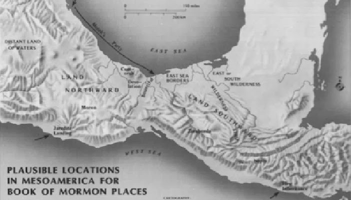
For the first time, a horizontal Land of Promise map or model was introduced, and by the head of anthropology at Brigham Young University—obviously, it met with little resistance, especially by students and members with limited knowledge of the geography described by Mormon in the scriptural record.

So how did we get from a vertical, north-south map of the Land of Promise (like these above) to the Mesoamerican east-west layout? Well, it all started when M. Wells Jakeman, after receiving his Ph.D from University of California Berkeley, was brought into BYU to head up the archaeology department. Jakeman was already a Mesoamericanist, having written his doctoral dissertation based on based on a combination of archaeological evidence and Spanish documents relating to the history of the Yucatan—Jakeman believed that archaeology must be grounded in a firm understanding of documents, and he did not see archaeology as a sub-discipline of anthropology. He was an early member of the advisory board of the New World Archaeology Foundation (NWAF). He was also the author of The Origin and History of the Mayans, and was a firm believer in Mesoamerica as the land of the Nephites before he ever arrived at BYU.
His first class was entitled “Archaeology and the Book of Mormon,” and centered in Mesoamerica; later the NWAF was attached to BYU as an agency for field research in Mesoamerica, and the exclusive agent for archaeological excavations in Mesoamerica. John L. Sorenson earned his degree in Archaeology in 1952 and was appointed to the department the following year. He left to go to UCLA where he received a Ph.D. in anthropology in 1962, and returned to BYU where he originated the anthropology program and ran it for the next 14 years. He later did full-time research and writing on ancient American civilization and the Book of Mormon in connection with the Foundation for Ancient Research and Mormon Studies (FARMS). He was closely involved with FARMS for 28 years including nearly five as editor of the Journal of Book of Mormon Studies.
Originally, FARMS was founded in 1979 by John W. Welch for the purpose of defending the Church through scholarly research and apologetics. As it grew others became involved in the organization, such as Daniel C. Peterson, Kirk Magleby, John Sorenson and others. Peterson, in an interview with PBS in 2006 described the beginnings of FARMS by stating, “We wanted to use the training we were getting in ancient languages, ancient history, Middle Eastern studies and so on to examine the Book of Mormon on the assumption that it really is an ancient text with roots in the Middle East or in Mesoamerica.”

In the PBS interview, Dr. Peterson drew several parallels from Mesoamerican culture and archaeology. Ultimately FARMS was organized and funds were solicited and raised, and over a number of years it became one of the premier apologetic organizations outside of the Church, and its influence grew as did its promotion of Mesoamerica as the setting for the Book of Mormon
Throughout these years Mesoamerica has been, and still is, the major emphasis of archaeology in these groups and at BYU, and has become as we see it today the only location considered or presented as the Book of Mormon Land of Promise. It is interesting that Mesoamerica has been placed in a position of pre-eminence as the Land of Promise when it simply does not meet the very basic descriptions that Mormon gave us.
For starters, Mormon tells us throughout the entire scriptural record that the Land of Promise ran north and south, with a very clear outline in Alma 22:27-34 where Mormon inserts a 568-word description where he uses the four cardinal points 29 times—with every description of land lying to the north of another, beginning with the Land of Nephi in the far south. Yet, despite this, Sorenson would have us believe the Nephite lands were laid out east to west, not north to south—a belief held by all other Mesoamerican Theorists since despite Mormon’s very clear descriptions to the contrary.
To justify this, Sorenson introduces a convoluted, lengthy and very complex explanation as to why the Nephites did not use the cardinal compass points as they are known today—rendering both Mormon’s descriptions and Joseph Smith’s translation inaccurate and his own complicated thinking superior in its accuracy. The remarkable thing about it is, members have accepted it without much comment.
However, differences do not just lie in the shape and direction of Mesoamerica, but in almost every aspect of comparison between Mesoamerica and Mormon’s descriptions, with the list of discrepancies going on with example after example showing how Mesoamerica simply does not match Mormon’s descriptions in the scriptural record, which has been covered in these posts over the past three-and-a-half years (also see the book Lehi Never Saw Mesoamerica, for more examples, and the book Inaccuracies of Mesoamerican & Other Theorists, for specific differences between the scriptural record and Mesoamerican descriptions).


No comments:
Post a Comment