

The
Bay of Quayaquil, showing its mouth from Salinas to Punta Pariñas, the the
channels around Puná Island, as well as the main rivers
The Gulf represents 3,000-square-miles of watershed, and has a depth ranging from 600 feet along the shelf to 59 feet along the inner shoals. The depth of the Morro and Jambeli channels at the inner boundary of the Gulf is 184 feet and 72 feet respectively.
Between the East and West Cordilleras of the Andes is the intra-andine depression running north and south above Guayaqui, the northern end is filled with lava, truffs and agglomerates derived from recent volcanoes which are the most striking feature of the Ecuadorean Andes. These volcanoes are mostly found in the northern half of Ecuador.
The Gulf of Guayaquil separates the humid, forest-covered coastal plain of Ecuador from the arid, barren coast of Peru, these two areas being widely dissimilar. On the north side, a great many shallow tidewater channels, along with swamps and estuaries, between the Gulf and Guayaquil. Near the Gulf are some low, swampy islands or mud flats covered with mangrove thickets in the lower Guayas river.
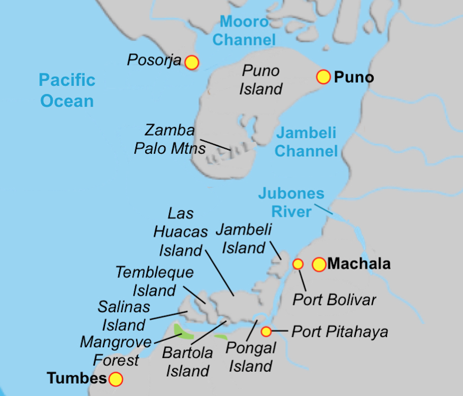
At the north end of the Gulf, is the Morro Channel between Puná Island and the mainland to the north. It is filled with shoals and dangerous for shipping, forcing most vessels around the south end of the island and up along the eastern Jambeli channel.
North of Guayaquil, from Santa Elena northward is the 18-mile-wide, 330-mile-long Cordillera Costañera, which reaches from Esmeraldas in the north to Guayaquil in the south, at which point they lose the character as a mountain chain and become a series of hills and small mountains. Where it moves from Manabí to Guayaquil, it is known as the Chongón-Colonche Cordillera.

The present location of Guayaquil and surrounding area, including Santa
Elena Peninsula, the Chóngon-Colonche Mountain Range and the Jambeli Channel
and Island
East of the Gulf itself, are the Cordillera Occidental (Western Chain) and the Cordillera Oriental (Eastern Chain), the latter being wider and generally higher, with peaks averaging over 13,123 feet, including the highest point in Ecuador, Mount Chimborazo at 20,561 feet. In between these two cordilleras, lies the intermontane basin or plateau, filled partly with alluvium from river or delta deposits, creating very fertile soil.
Several transversal mountain spurs, known as nudos, cut across the plateau. Near Girón in the east, the Nudo del Azuay, at 14,763 feet the highest of these transversal spurs, divides the Sierra into two subregions—the area of modern volcanism to the north and the area of ancient volcanism to the south. The former area consists of newer, higher mountains than those in the ancient volcanism section, which with time have eroded to lower levels.

The
mangrove swamps o forest that covers much of the Jambeli Archipelago and the
southern mainland north of Tumbes. A never-ending supply of wood for building
ships
These forests stabilize the coastline, reducing erosion from storm surges, currents, waves, and tides, with the intricate root system of mangroves also making these forests attractive to fish and other organisms seeking food and shelter from predators, such as shrimp and oysters. The roots themselves also slow the movement of tidal waters, causing sediments to settle out of the water and build up the muddy bottom.
Beyond the mangroves moving inland are salitral and sartenjal, or saltpeter deposits, and then sabanas, or grass-covered savannahs or plains before the sharp rise of the Cordillera Occidental or Western Andes. That distance varies slightly along the littoral of this coastal Gulf, but is about twenty-five miles in width between where the narrow littoral terminates and the plain widens considerably.
It might be of interest to know that along the Santa Elena Peninsula, where much of the mangrove swamps and salt marches are located, is where the Jaredites landed in their barges, swept into shore by the coastal current that brings much in the way of floating flotsam and debris into land. Just offshore there is where the main (Humboldt or Peruvian) current bends westward to eventually head back across the Pacific toward Indonesia and Australia; however, in the bend, the side current continues northward and heads into the peninsula—the furthest westward land mass along the western shores.
Anciently, along this shore and around the Gulf of Guayaquil, mangrove swamps and forests dominated the shoreline. Currently, mucho f what is left of this is found along the Jambeli Island and channel on the western and southwestern shore of the Gulf.
To the north of Puná Island is the Morro Channel and filled with shoals and dangerous for shipping. The 330-square-mile Puná Island is a low-lying swampy and muddy island except for a ridge that runs through it called the Zamba Palo, with the eastern shore having some high bluffs. Its shores, except for the eastern shore, is filled with mud banks (when Pizzaro attacked the area in 1531, it took him six months to subdue the large concentration of natives on the island).
The Gulf of Guayaquil of the coastal province is the largest gulf on the Pacific coast of South America between Panama and Chiloe in southern Chile, and the largest estuarine ecosystem on the coast at 40,000 square miles. The Gulf has historically been defined by an outer and an inner estuary. The outer estuary, referred to as the Gulf of Guayaquil, has a shelf boundary a distance of about 127 miles from the mouth of the gulf running inland to Puná Island at the mouths of Morro and Jambeli channels. The inner estuary, referred to as the Guayas River estuary, can be classified as a tectonic estuary, which extends about 45 miles from its mouth at the northern shore of Puná Island to the tidal signature of the Guayas River
To the northwest, a relatively large sub-estuary, known as the Salado, has freshwater input restricted to wastewater from the city of Guayaquil and to the southeast, the Churute sub-estuary is influenced by the Churute and Taura Rivers, the latter being near the Zarumilla River. More than 20 rivers, with a total watershed of 31,889-square miles, discharge into the Gulf.
This Gulf that cuts into the land, separating the northern Ecuadorian land from the southern portion and Peru, is effectively a sea that divides the land, as Moroni described it.


No comments:
Post a Comment