First of all, before outlining these points with a specific location, let us just briefly show why the Mesoamerican, Heartland and Great Lakes theories location for their Hill Cumorah does not meet the scriptural criteria:
Mesoamerica: One very important fact is that the Jaredite Omer, who was the king in Moron, “departed out of the land with his family, and traveled many days, and came over and passed by the hill of Shim, and came over by the place where the Nephites were destroyed, and from thence eastward, and came to a place which was called Ablom, by the seashore, and there he pitched his tent” (Ether 9:3). That is, he traveled many days from Moron to Ablom; the latter being near the east seashore. While we do not know how long “many days” travel would be, or the distance that would cover, we can assume it was not a short distance, about 68 to 87 miles, that the hill Vigia in Veracruz is from the so-called narrow neck of land (Isthmus of Tehuantepec) of Mesoamerican theory. Secondly, their hill Cumorah (Cerro Vigia) is only four miles from the Gulf of Mexico (their Sea East); however, Mormon suggests a much further distance between the hill Cumorah and the place called Ablom, which was by the seashore, but not necessarily on the seashore.
Hill Cumorah in New York, note (yellow
arrow) how short the hill is and how gentle the slope up is, and how little
viewpoint it provides to a vast surrounding area
So, based on the criteria laid out for us in the scriptural record, let us consider the mountain site in northern Ecuador, near the most northern part of the Land Northward.
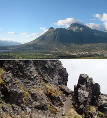
The stratovolcano mountain Imbabura in
northern Ecuador—a major dominant topographic feature in the region
Location of Cerro del Imbabura, or
the Hill Cumorah, in Ecuador (Land Northward)
The mountain is by far the most dominant geographic feature of the area, is important to the local cultures and represents a highly treasured location, said to be enchanted, and has a huge fresh-water lake (Laguna de San Pablo, a former volcanic crater that filled with water eons ago) and streams all around to provide drinking water for such a gathering of warriors and their families for four years, as well as plenty of forage of birds, amphibians and invertebrates throughout this inter-Andean valley surrounding the mountain. And as mentioned before, this area is extremely fertile where crops could have grown for the four years the people gathered and prepared to do battle with the Lamanites.
Top:
Imbabura not only is the most dominant feature in the area, but also has
enormous space around it for half a million people or more to do battle;
Bottom: the mountain would provide numerous hiding places for the embattled
survivors of the first day and is certain high enough to see out over many
square miles of battleground below
Omer’s journey from Moron to Ablom,
passing both the hill Shim and Ramah/Cumorah known today as Imbabura
Mormon points out that this journey or distance took “many days,” which typically suggests a long distance in connection with simple language like “and from thence to a place which was called Ablom” or “and he came up unto the land of Moron where the king dwelt,” or “he returned to the city Nehor,” or “he came over by the place where the Nephites were destroyed.” This distance from the area of Moron (Riobamba) to Imbabura is about 200 miles.
2. Cumorah, Shim, Ablom and the East Sea (Ether 9:3)
From west to east, the Cotachi (hill Shim) to Imbabura (hill Cumorah) is 15 miles; the distance from Imbabura to the place called Ablom was about 12 miles, and to the ancient east seashore (Cabeceras Cofanes-Chingual) about 15 miles. This ancient seashore is now within the Cuenca Chingual mountain range of the Andes and one of the last intact mountainous regions in Ecuador, in which its hydrology, geology, soils, vegetation and flora, amphibians and reptiles, birds, mammals, archaeology, and current communities have been surveyed (Ecuador, ed. Corine Vriesendorp et al., University of Chicago Press, Field Museum of Natural History, 2010).
3. The hill Cumorah was a significant landmark the Lamanite king would know (Mormon 6:3);
This mountain stands out and can be seen for miles around the region. Given the slightest direction and the hill can easily be reached. It sits in the midst of the huge Chota Valley. Along with Cotachi Mountain, is distinct in its appearance.
4. Beyond the Land of Desolation (Alma 22:30)
5. Located in the Land Northward, north of the narrow neck and Desolation (Mormon 4, 5:3-7)
The narrow neck of land ran along the east bank of the Gulf of Guayaquil, from there the Land of Desolation stretched northward across the Central Oriental Occidental, where the Plains of Agosh were located, then the Valley of Gilgal and north of that was the lake district of the Plains of Imbabura, which stretch northward into the Cerro Imbabura in an area of “many waters.”
(See the next post, In Search of Cumorah – Part VII,” for the last seven points of the 12 criteria used in the scriptural record to describe the physical arrangement and facts surrounding the scriptural hill Cumorah/Jaredite Ramah)


No comments:
Post a Comment