Tuesday, October 30, 2018

Where Theorists Go Wrong – Part IV

Continued from the previous post, regarding the errors theorists make by not investing a little time in study and research regarding their treasured opinions and beliefs. For any theory regarding the geographical setting of lands in the Book of Mormon, it must meet two specific requirements: 1) Match the scriptural record in every detail, and 2) Match the current or earlier terrain and topography of the general geological studies of the area.
    When it comes to the Heartland Theory and the model of the Mississippi River being the Sidon River of the Book of Mormon, neither of these two factors are met. As an example:
1. The Sidon River mentioned throughout the Nephite record was a river that had its head, or the source of the river, in the highlands or mountains south of the Land of Zarahemla, within the Narrow Strip of Wilderness that separated the Land of Zarahemla on the north from the Land of Nephi on the south (Alma 22:27; 2:15).
2. The Sidon River was at a higher elevation than the Land of Zarahemla, making the Narrow Strip of Wilderness at a higher elevation and the Land of Nephi south of there at a higher elevation than the Land of Zarahemla. This is attested to by two facts: 1) The source or head of the river was in this area, and would have required an elevation higher than the land of Zarahemla in order to flow “by the land of Zarahemla” (Alma 2:15); and 2) It is continually mentioned that the Lamanites “went down” to the Land of Zarahemla from their Land of Nephi, and that the Nephites “went up” to the Land of Nephi from their Land of Zarahemla.
    Thus, the Sidon River flowed from south (higher elevation) to north (lower elevation). And the Land of Nephi, Narrow Strip of Wilderness, and the head of the Sidon River was at a much higher elevation that that of the Land of Zarahemla.
    To compare that with the Mississippi River, which runs from north to south, and the around the Mississippi River, throughout its length, are basically flat lands, with higher level bluffs along its banks, making the Mississippi River inconsistent with the Sidon River and not interchangeable land forms.
    To stress this, what we know from the scriptural record is that the Mississippi did not basically run east and west, as is shown in numerous statements indicating it had “east banks” (Alma 2:15, 2:17, 6:7, 16:7, 43:53, 39:16); and also had “west banks” (Alma 8:3, 43:27, 43:32, 43;53). Not only is there no mention of north or south banks, a river running north and south would not have north and south banks.
The Mississippi River runs basically and predominantly north to south, here shown passing one of the many bluffs along its bank 

Now, despite the fact that the head of the river is south of Zarahemla and runs past the east borders of the land of Zarahemla, which is a land that runs east and west, “from the east to the West Sea,” Heartland theorists, such as Rod L. Meldrum, has specifically said: “Rivers often make significant changes in direction over short stretches as they wind around geographic obstacles. One should not assume the River Sidon, or any lengthy natural river, would run exclusively in exactly one direction” (Meldrum, “The Mississippi: Could it have been River Sidon?” Book of Mormon Evidence, June 4, 2010).
    This is a surprising comment, since Meldrum’s river Sidon is claimed to be the Mississippi River, which American river runs predominantly north to south for 2,300 miles, from Minnesota to the Gulf of Mexico. While twists and turns exist throughout its long course, there is no question looking at it on a map, that the river predominantly runs north to south. In addition, the Nile River in Egypt runs predominantly south to north for 4,258; the Yenisei River in China, runs predominantly south to north for 3,441 miles, and the Amazon in South America runs predominantly west to east for 3,976 miles, making three of the four longest rivers in the world run predominantly in one direction. Thus, Meldrum’s argument is faulty and completely without merit.
The plains of the lands between the Rocky Mountains and the Appalachian and far eastern mountains. Between the Great and Central plains, the various plains throughout the Midwest and central states, the land form is basically one of flat land with some low-lying and rolling hills 

However, the alluvial plains along the Mississippi River, is not the only matter. When it comes to the difference in elevation of the Book of Mormon lands surrounding the Sidon River from its course “running by the land of Zarahemla” to its “head” in the Narrow Strip of Wilderness, showing specific differences in land form and elevation, we do not find anything like that along the Mississippi. In fact, from its entire length, the river runs through one general open plain, stretching from the eastern foot of the Rocky Mountains to the Mississippi River, then 760 miles eastward to the system of mountains known as the Appalachians in which begin in eastern Pennsylvania and travel southward for 1500 miles to around the northern borders of Alabama and Georgia. 
    The approximate mean elevation, according to the U.S. Geological Survey, of the ten states along the Mississippi River along the West Bank are:
Minnesota                1200
Iowa                           1100
Missouri                     800
Arkansas                    650
Along the East Bank are:
Wisconsin                  105
Illinois                        600
Tennessee                  900
Kentucky                    750
Louisiana                   100
Adjacent to these states to the east are:
Michigan                    900
Indiana                       700
Ohio                            850
Mississippi                 300
Alabama                     500
Further east are the states of:
New York                 1000
Pennsylvania           1100
North Carolina          700
South Carolina          350
Georgia                       600
In this part of the Midwest and Central United States, where the Mississippi flows, the land is predominantly flat, from state to state to state. Certainly there is no area anywhere close to the Mississippi River that equates to the elevated Land of Nephi or the elevation of the Narrow Strip of Wilderness from where the Sidon River flows downward 

The point should be obvious that when Mormon describes a land that is considerably higher in elevation, saying “the Lamanites will cross the river Sidon in the south wilderness, away up beyond the borders of the land of Manti” (Alma 16:6), with Nephites going up to the Land of Nephi, and Lamaniates going down to the Land of Zarahemla, such would not be possible along the Mississippi for several 690 miles to the west and 750 miles to the east. There is simply no way that Meldrum, or other Heartland theorists, can claim that the Mississippi River is the Sidon River.
    This is where theorists go wrong—they start out believing that Zarahemla, Iowa, is the Zarahemla of the scriptural record and go to great lengths to quote from tee D&C about the Lord telling Joseph Smith to name that area by that name, then take the giant leap to believing that ergo that area must be the original Zarahemla. Then they look around for other means described in the land of Zarahemla, with the Mississippi their obvious candidate for the Sidon River, which makes a lot of sense to them.
    However, the fact is that neither Zarahemla, Iowa, nor the Mississippi River match the descriptions and land arrangement described in the Book of Mormon, as any search of the land and its terrain, as well as its history, would obviously show it was not compatible with Mormon’s descriptions. But still, they go with their interest rather than the scriptural record. And in that, they err.

Monday, October 29, 2018

Where Theorists Go Wrong – Part III

Continued from the previous post, regarding the errors theorists make by not investing a little time in study and research regarding their treasured opinions and beliefs. For any theory to withstand scrutiny, it must first be evaluated by its developer against the scriptural record and then against the natural terrain, topography and the reality of their location now and in the past. Ancient changes are a thing of much geological study and work, and often such findings preclude one’s ideas of what appears normal or natural on a flat map.
It should be kept in mind that that the entire Mississippi River from its source in Itasca Lake in Minnesota, to the Gulf, even today with all the work that has been done on the river by the Corps of Engineers to make and keep it open to shipping, was recently the scene of a paddle wheel vessel called “The American Queen,” a $65-million replica of the early paddler wheelers, that ran aground on a sand bar and was stuck there from 5am on Monday until 7pm on Wednesday, for more than 3½ days, while not even huge tow boats could free the paddlewheeler, until three dredges, a rising river and pumping fuel out of the vessel and lighten it eventually freed it (UPI story, June 19. 1995; Carol Barrington, “Sandbar Dashes Nary a Spirit,” Chicago Tribune, July 2, 1995).
    The River’s history began with ice sheets during what is called the Illinoian Stage, blocked the Mississippi near Rock Island, Illinois, diverting it to its present channel farther to the west, which is the current western border of Illinois. The current man-made, and now abandoned, Hennepin Canal roughly follows the ancient channel of the Mississippi downstream from Rock Island to Hennepin, Illinois. South of Hennepin, to Alton, Illinois, the current Illinois River follows the ancient channel used by the Mississippi River before the Illinoian Stage (E. D. McKay and R. C. Berg, “Optical Ages Spanning two Glacial-interglacial Cycles from Deposits of the Ancient Mississippi River, north-central Illinois, Geological Society of America Abstracts (with Programs), vol.40, no.5, 2008, p78).
The Coastal Delta where the Mississippi River empties into the Gulf of Mexico has changed drastically over the years from ancient BC times to today; however, it should be noted, that this is from the emptying of five major river sediments being moved downriver to its mouth—the rest of the river has not changed anywhere near that drastically, though changes have been noted

To make sure people like Meldrum and other theorists don’t try to pass this off under the pretext of the Mississippi River being different in the past, “radiocarbon dates obtained from the lower Illinois valley indicate that the terrace sediments were deposited sometime between about 13,100 and 9,500 years ago (11,100 to 7500 BC.) Soils developed on the terrace are variable in their physical, chemical, and mineralogical properties, which reflect the composition of the clayey sediments” (Mark A. Flock, “The Late Wisconsinan Savanna Terrace in tributaries to the Upper Mississippi River,” Science Direct, vol.20, iss.2, Elsevier, September 1983, pp165-176).
    The point is, the Mississippi River has basically been in the same general area. For thousands of years and what small changes in actual route have not affected its depth, width, or problems for deep sea sailing vessels to move up the river. Meldrum and other theorists who claim things about the Mississippi obviously ignore the facts by those who have studied this river for more than a hundred years.
    For those looking at such theorists’ ideas, it is important when evaluating different models and opinions connected to their theories, to evaluate them against known facts regarding the areas and physical features as well as the geologic support for their point of view. This is especially true when theorists like those who promote the Heartland of the U.S. as the Land of Promise insist that the Mississippi River is the Sidon River of the scriptural record.
    So much is known about the distant history of this river that knowing such facts aids one in determining claims made by such theorists as Rod L. Meldrum and other Heartland theorists. The important point is that the Mississippi River does not match the descriptive terms given to describe the Sidon River and its location and source, yet this fact—not opinion—seems to have no meaning to theorists who want to place their Land of Promise in the contiguous United States.
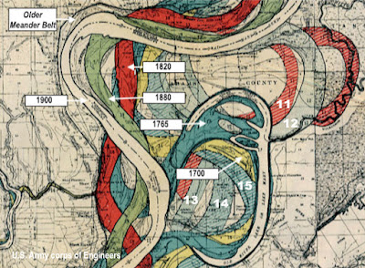
The Mississippi Meander Belt, showing previous courses of the Mississippi River. The U.S. Army Corps of Engineers has listed 20 different courses, with four older than the Meander Belt. White numbers reflect the previous courses that are undated, but preceded the last date shown going backward into antiquity

The point is, the path or course of the Mississippi has been well studied and is well understood throughout its long history, and not much about it has changed—it has always flowed more or less in the same basic area, has always been a shallow river, basically about a mile wide in most places (except where it enters a lake, many of which are man-made to accommodate the river, and mostly in Minnesota), and until the Corps of Engineers, the river could handle nothing much larger than canoes, barges and packet boats as mentioned earlier. It has always been fraught with rapids, eddies and sand bars because of its extremely shallow bottom and continual sediment deposition.
    It should also be noted that the River’s course in Louisiana somewhere between 3000 BC to 1000 AD followed what is today called the Bayou Teche, a 125-mile long waterway running along the Coteau Ridge as its west bank from Port Barre to New Iberia in south central Louisiana, about 30 miles west of the present Mississippi course a little north of Lafayette, about 20 miles north of the Gulf. This was the original Mississippi course through Louisiana at the time the river developed a delta it is believed about 2800 to 4500 years ago. It should also be understood that the river then was carrying nineteen times the volume of water compared to the present-day flow of the Mississippi River—that is, 11,267,000 cubic feet of water per second (Mississippi today is 593,000 cubic feet per second); compared to the largest river flow today, which is the Amazon River at 7,380,765 cubic feet).
    It would be interesting to know, from those who claim Lehi sailed up the Mississippi River from the Gulf of Mexico, how exactly they did that in a vessel “driven forth before the wind.” After all, this would have been especially difficult since winds tend to blow along the course of a river’s direction, or in this case blowing southward, making Lehi’s ship having to sail against the wind and against the fastest known current now in existence, with only sail power to move the ship.
    In addition, the River’s actual present course was about the same throughout its history, with the change in the southern extremity through a portion of Louisiana, which, in 1000 AD, was finalized as we see it today. However, in 3000 BC, it was affirmed to be in its present position beyond central Louisiana. Anciently, as now, the Mississippi River began heading northward from the North Arm of Lake Itasca and continued northward for about 15 miles to an area called Mississippi Headwaters, then turned east to Lake Irving and Lake Bernidji, continuing east to Stump Lake, then heading southeast to the Leech Lake Reservation, a composite of several lakes of which the Mississippi passed through, then bent toward the south about 160 miles north of Minneapolis and headed southward to wind through what is now the Twin Cities and on its main course direction to St. Louis, and down to Cairo, Illinois where it picked up the Ohio river at the confluence before continuing on southward.
    Now, with all this in mind regarding the completely known background of the Mississippi River and the surrounding countryside, let’s take a look at Meldrum’s claim that the Mississippi River is the River Sidon of the Book of Mormon

Top: Baton Rouge is about 245 miles upriver form the Mississippi Delta and mouth of the river; Bottom: The Shallows above Baton Rouge from the Istrouma Bluff to Solitude Point, along this stretch of river had to be dredged and deepened by the Corps of Engineers in order for shipping to proceed beyond Baton Rouge northward

245-miles along the South Pass route from the Gulf of Mexico, Baton Rouge, originally called Istrouma by the native people, sit atop of a 50-foot Istrouma Bluff on the east bank of the Mississippi River—the first high ground between there and the Gulf. This high ground is the last of the Mississippi Loess Bluffs, which lie along the Blufflands (the highest point of the Terraces Region) along the edge of the Pleistocene Escarpment from Baton Rouge northward. The name Baton Rouge, means “red stick” and refers to a pole adorned with animal carcasses placed on the high ground in Baton Rouge marking the dividing line between the tribal lands of the Houmas to the north and the Bayougoula to the south. This marker is thought to actually have been on Scott’s Bluff near the present location of Southern University. All the land seen from here was created in the last 7000 years by the annual flood and sediment accretion process. To the north of Baton Rouge, along the River, are the endless trees, back channels and sandbars of the wild Mississippi.
    From Baton Rouge to Wilkinson Point, where Southern University is located, then to the west around Thomas Point, which is a hairpin curve—for some geologic or hydrologic reason not understood, the bends of the Mississippi through south Louisiana do not make smooth rounded curves like they do to the north; the bends come to sharp points, blind corners and tight turns. In addition, at this point, the river enters “full throttle” going first in one direction, and then makes chaotic swirly changes to head in the opposite direction, causing difficulty in steering and maneuvering up the river. At Mallet Bend and back east toward Mulatto Bend the river was very shallow in ages past clear up to the point where the Corps of Engineers dredged the river to allow paddlewheel boats to pass. Before that time, no kind of vessel from the sea could get beyond Baton Rouge.
(See the next post, “Where Theorists Go Wrong – Part IV,” to see how in not understanding the history of an area, that it does not automatically qualify for a Land of Promise site, because of its name or its proximity to other sites)

Sunday, October 28, 2018

Where Theorists Go Wrong – Part II

Continued from the previous post, regarding the errors theorists make by not understanding the reality of their ideas and beliefs nor in their comparing them against known facts now and of the past. For this reason we have written several times about the Mississippi River in respect to the Heartland and Great Lakes theorists ideas and their models, which almost all show the Mississippi River as the Book of Mormon Sidon River. The simple fact of the matter is that the Mississippi River does not match the descriptive terms given to describe the Sidon River and its location and source, yet this fact—not opinion—seems to have no meaning to theorists who want to place their Land of Promise in the contiguous United States.
    Once again, it should be kept in mind throughout any such discussion that the Mississippi River is an extremely well-known river and area and perhaps the most thoroughly investigated and evaluated river in the world. It is also one of the most managed rivers on record.
The Atchafalaya Channel may well become the Mississippi River if the Corps of Engineers plan fails to save the current course 

As an example, without the intervention of the Corps of Engineers today, the current channel of the Mississippi would slow to a trickle and left to its own devices, would shift west toward the Atchafalaya River channel, which is currently a 137-mile long distributary, a stream that at one time branched off the Mississippi and Red rivers in what is known as bifurcation.
The Mississippi River in its history has had several major course changes, specifically in Louisiana where the sediment buildup has become extensive, creating several deltas along the Gulf 

In fact, the river’s current course has existed for only about eleven hundred years—it is constantly eroding channels in some places and dropping sediment in others, causing its path to wander.
    If we go back in time, there have been three earlier courses dating to the last two millennia BC times and one around 1300 AD, since the Mississippi, like all alluvial (sediment-bearing) rivers, the winds through its valleys, caving banks and topping them in flood times. Occasionally, it cuts across the neck of a sharp loop, begins eroding another bank and gradually forms a new loop. About the 15th century A.D., a westwardly meandering loop of the Mississippi River, later called Turnbull’s Bend, broke into the basin of the Red River and captured the Red. The Mississippi also intersected a small distributary of the Red River which flowed south and later became known as the Atchafalaya Channel, or distributary.
    However, the point of this is to show both that the course of the Mississippi has changed from time to time throughout its history, which courses, up to 20, have been recorded and logged by the engineers who have spent lifetimes working on the studies, evaluations and maps. In all that time, with all the mapped course changes, the history of the river is both extremely well known, and at no time was the river’s depth basically different.
    As an alluvial, sediment-bearing river,  it has remained shallow throughout its history and at no time was it ever considered to be any deeper than it was before the Corps of Engineers dredged, deepened and widened I in the 18th and 19th centuries.
The Mississippi drainage Basin, an area of 1.2 million square miles of the 2.95 million square miles of contiguous United States. Note the light colored areas throughout the heartland and around the Great Lakes—this represents low, basically flat land, without mountains, ridges, hills, etc. There are no mountains “whose height is great anywhere east of the Rocky Mountains

The river bed of the Mississippi was initially a low-lying or shallow basin, that filled with water over time as well as continually having sediment from upriver setting along its bottom, especially form the confluence of the Ohio River at Cairo, Illinois, and the Tennessee, Missouri and Arkansas rivers. This continual deposition of sediment has always keep the Mississippi River quite shallow until modern times when the Corps of Engineers is tasked to keep the river open to ship traffic. However, in its days before the Corps of Engineers, the Mississippi was shallow its entire length except where it passed through numerous lakes throughout its course in Minnesota—but once into Iowa, Illinois and Missouri, it was extremely shallow, passing over several rapids, the main one in the Des Moines Rapids between Nauvoo, Illinois and Keokuk, Iowa-Hamilton, Illinois is one of two major rapids on the Mississippi River that limited Steamboat traffic on the river through the early 19th century.
    Various attempts to make the river navigable started in 1837 when a channel was blasted through the rapids by the U.S. Army corps of Engineers team, led by Robert E. Lee, and 40 years later, a canal around the rapids was built, which has since been obliterated by the building of Lock and Dam No. 19. These rapids were eleven miles long, extending from the mouth of the Des Moines river northward, past Keokuk, Iowa to Montrose. The interesting thing about these rapids is that no one observing the calm water flowing through this eleven mile area would have known there was such danger lurking just inches beneath the surface. In fact, the fall of the river through this eleven miles is only 22-feet, or one foot every half mile. The bluffs on each side of the river were contiguous to the shore line, and varied from one hundred to two hundred and fifty feet above the water.
    Through here, the river bottom was a broad, smooth rock, seamed by a narrow, crooked channel, or, in some places, several of them, alternately widening and narrowing, shoaling and deepening; nowhere good navigation. The rapids, therefore, were not broken and noisy, but, the decent being gradual, the water flows over its bed in a broad, smooth, unbroken sheet, with nothing but the faintest ripple on its surface to indicate the dangerous places (Lt. J. E. Griffith, U.S. Corps of Engineers, Asst to General Wilson, “The Des Moines Rapids of the Mississippi River, and Its Improvements,” The Annals of Iowa, vol.1870, no.2, State Historical Society of Iowa, 1870, pp149-150).
450 miles south of the present site of Nauvoo in Illinois, and across from the old township of Zarahemla, Iowa, a small peninsula now known as Mud Island, and much earlier as “City Island,” jutted out into the river along the shore of present day Memphis, Tennessee, blocking river traffic. Before the Corps of Engineers dug up and cut away half of the western side of the peninsula, the river was quite narrow with silt, sand and gravel continually forming along the bottom and river, creating sandbars that were enhanced over time by flooding, causing the area to continue growing, resulting in the forming of small to large islands in the narrowing river, and infringing the water depth and movement up and down the river (Beverly G. Bond and Janann Sherman, Memphis: In Black & White, Arcadia Publishing, Memphis, 2003, p160). Obviously, the Corps, needing a place to dump the mud, they conveniently placed it on top of the remaining island, effectively raising the island’s height so it permanently sat above flood stage, as it does today.
    Additionally, the average width through this area is 4,500 feet (about 85 one-hundredths of a mile), the mean depth is 2 and four-tenths feet, and surface velocity is two and eighty-eight hundredths feet per second. Thus, the tortuous, uncertain channel over these rapids precludes the possibility of any craft navigating them in low water. Even if the channel itself was wide and deep, no pilot would dare to undertake to pass them (Ibid, p150).
    For those Heartland or Great Lakes theorists who maintain a belief in Lehi sailing up this river to reach the so-called city of Zarahemla in Iowa, or further northward to the Ohio and on to the Great Lakes region, need to contend with this eleven miles of impossible-to-navigate river that neither Lehi’s ship, nor even a canoe, could have managed to get past, and that does not include the ancient rapids that once kept the Mississippi from being navigable north of Baton Rouge.
(see the next post, "Where Theorists Go Wrong - Part III," for a further understanding of how the history of an area has to support its scriptural descriptions)

Saturday, October 27, 2018

Where Theorists Go Wrong – Part I

When those who write, talk about or discuss the Book of Mormon geographical setting and their Land of Promise location and model, stray from the scriptural record to make their points, they are in deep water—and as time goes on and factual challenges based on the scriptural record arise, they move further away from Mormon’s descriptions in order to defend their erroneous, but believed scenario, and end up floundering more and more. This is generally the case when people embark on opinions or points of view that are not well founded in the facts of the scriptural record.
    Take Rod L. Meldrum the Heartland Theorist guru of late who wants to place the Land of Promise in North America, along the Mississippi River region, the Great Plains, and even to the Great Lakes. This has led Meldrum to claim that the Sidon River of the scriptural record being the Mississippi River that divides the Great Plains.
    Now the Mississippi flows from Minnesota in the north to the river’s delta and the Gulf of Mexico in the south, a distance of some 2,320 miles, with its length increasing or decreasing as deposition or erosion occurs at its delta, or as meanders are created or cutoff. 
Coupling the Great Plains with the High Plains, Great Basin, Coastal Plains and Central Lowlands, the area of land involved in more than 40% of the continental United States—all of which is extremely flat where no mountain ranges or peaks shoot up in the skyline, “whose height is great.” Most of this makes up the Mississippi, Ohio, and Missouri drainage basins

The river crosses through ten states, and with its many tributaries, as the Mississippi watershed drains all or parts of 31 states and two Canadian provinces between the Rocky and the Appalachian Mountains, and between southern Canada and the Gulf of Mexico.
    Thanks to the Corps of Engineers, the Mississippi River that used to be about one-mile-wide at its widest, is now flowing as a river two miles wide at the widest navigable point at Lake Pepin, about fifty miles south of Minneapolis, between Hager City and Reads Landing where it is the dividing border between Minnesota and Wisconsin.
    While Meldrum, and other Heartland theorists, seem not to give any credence to Mormon’s description of the land around the Sidon, in order for one to evaluate such a claim, knowing what the land around it was like becomes critically important. As an example, Mormon gives us two major understandings of this land around the Sidon River where it flows past the Land of Zarahemla.
Suggested map showing the eastern portion of the Land of Promise along the Sea East where the Narrow Strip of Wilderness bisects the lands of the Nephites from the lands of the Lamanites (not to scale)

Two of Mormon’s points are:
1. The head or source of the Sidon River was in the narrow strip of wilderness, south of both the Land of Manti in the east, and the Land of Zarahemla, in the center and and west (Alma 22:27). Now since the northern border of the narrow strip of wilderness abutted against the Land of Zarahemla and the southern border abutted the Land of Nephi. Within this narrow strip, lay both the Nephite. city of Manti, and the head or source of the Sidon River. In addition, the Land of Zarahemla was west of the Valley and Land of Gideon, which means the city of Gideon was in the east, toward the sea, but not as far as Moroni, Lehi, Morianton and Nephihah. To place Manti then, we find that Alma was south of Gideon when it is stated: “As Alma was journeying from the land of Gideon, southward, away to the land of Manti (Alma 17:1), that Manti is way up in the Mountains or highlands or a high elevation, since: “Behold, the Lamanites will cross the river Sidon, in the south wilderness, away up beyond the borders of the land of Manti (Alma 16:6)—which also suggests that the head of the Sidon River was further south and higher up in the mountain from Manti, with Manti on the west of the Sidon  (Alma 43:32).
    Thus, Manti is near the head or source of Sidon but the actual head of Sidon is in the South wilderness "away up beyond" the land of Manti (Alma 16:6). That puts it on a higher altitude than either Manti or Zarahemla, which would result in a northward flow of water between Zarahemla and Manti, since Manti is south of Zarahemla. Obviously, then, if the source of the Sidon is above Manti and flows to Zarahemla, the direction of flow would be to the north, for Zarahemla is north of the land of Manti.
2. Since the Sidon ran by the Land of Zarahemla, and not through it (Alma 2:15), and near the Land of Gideon (alma 2:20), then the Sidon River high up in the mountains of the narrow strip of wilderness was to the east of the city and Land of Zarhemla. Thus, the source, or head, of the Sidon is to the south of Zarahemla in the wilderness strip and the Land of Nephi to the south of the wilderness strip, it is then necessary for the land of Nephi and the narrow strip of wilderness to be at a higher elevation than the Land of Zarahemla. This is understood by the fact that the Lamanites, who later occupy the Land of Nephi, continually “came down” to the Land of Zarahemla to attack the Nephites
The Sidon River flowing northward down from its head or source in the mountains along the narrow strip of wilderness to the east of the Land of Zarahemla

The southern borders of the Land of Zarahemla were at a higher elevation than the rest of the Land of Zarahemla since after the battle along the banks of the Sidon between the Valley of Gideon and the Land of Zarahemla, another Lamanite army arrived from the city of Zarahemla. At this time, Alma “sent up a numerous army against them; and they went up and slew many of the Lamanites, and drove the remainder of them out of the borders of their land” (Alma 3:20-23,emphasis added). In addition, when Amalickiah fled the Land of Zarahemla, he “went up in the land of Nephi among the Lamanites and did stir up the Lamanites to anger against the people of Nephi” (Alma 47:1, emphasis added). We also find on several occasions the Lamanites came down from the Land of Nephi to the Land of Zarahemla to battle the Nephites (Alma 49:10-11; 51:11-12; 63:15).
    To make sure it is understood that “went up” and “come/came down” meant exactly that in the scriptural record relating to elevation, we find this terminology used in that manner regarding the Lamanites and Amalakiah (Alma 47:12-14) going up and coming down mount the hill Antipas (Alma 47:9). In fact, at one point the Lamanite Lehonti was asked to “come down to the foot of the mount,” and that “he durst not go down to the foot of the mount” (Alma 47:10-11).
The head of the Sidon River (red arrow) was located "away up beyond the borders of Manti," and thus at a higher elevation than Zarahemla; consequently, the river, which "ran by the land of Zarahemla" would flow (blue arrows) down and to the north
The point is, the Land of Nephi was at a much higher elevation than the Land of Zarahemla, and the narrow strip of wilderness between them was also at a much higher elevation than the Land of Zaarahemla, since the Sidon River’s head (Alma 22:29; 43:22; 50:11) or source, according to Noah Webster’s 1828 American Dictionary of the English Language, in which he states: “Head: to originate, to spring, to have its source, as a river.” This, then, makes the head or source of the River Sidon located to the south of the Land of Zarahemla and at a higher elevation. This means that the Sidon River flowed down toward the Land of Zarahemla, and then “ran by the land of Zarahemla” (Alma 2:15), which means the Sidon River ran from the south toward the north.
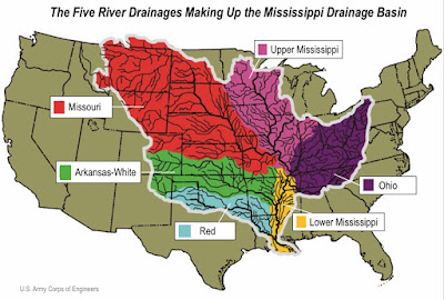
The Mississippi River Drainage Basin is the culmination of five different rivers, all moving sediment downstream toward the, four of the rivers converge with the Mississippi, which then drains into the Gulf, all the while depositing sediment along the river bed, causing the shallow river to alter its course slightly over the centuries through the meandering of the flow around these deposits 
 
With this in mind, let us return to the Mississippi River, which was originally formed from thick layers of the river's silt deposits, by both the Mississippi River itself, and five other tributary rivers: Missouri, Ohio, Arkansas, Red, and Ohio, making the Mississippi embayment—part of the alluvial plain—one of the most fertile agricultural regions of the country. This, in turn, resulted in the river's storied steamboat era, ushering in an extensive commercial and public transportation industry. During the Civil War, the Mississippi increased as an important route of trade and travel, and because of substantial growth of cities and the larger ships and barges that supplanted riverboats, the first decades of the 20th century saw the construction of massive engineering works such as levees, locks and dams, often built in combination—making the Mississippi for the first time, available to deep ocean ships. Prior to that time, the only river traffic on the Mississippi was in shallow or flat bottomed boat traffic, such as early canoes, barges and packet boats, followed by the big paddle wheelers. However, not until the river was dredged, deepened and widened, was it capable of handling ships of any draft, such as large wooden sailing vessels and the new steam boats and eventual diesels.
    So far, we have shown that, according to Mormon’s descriptions above, the Mississippi River and its adjoining lands do not fit the requirements of the Sidon River in the scriptural record, since it is basically flat land along the Great Plains, with no mountains of any kind around, nor is there any elevated land to the south of their area of Zarahemla, in Iowa, across from Nauvoo. Yet, this never seems enough to these theorists who insist that the Mississippi River drainage basin, especially near the River itelf, and eastward, from western New York to Pennsylvania, and around to Ohio, Illinois, Iowa and Missouri, then east into Kentucky and Tennessee made up Lehi’s Isle of Promise and the land of the Jaredites, Nephites and Lamanites.
(See the next post, “Where Theorists Go Wrong – Part II,” to see how in their not understanding the history of an area, that it does not automatically qualify for a Land of Promise site, because of its name or its proximity to other sites, but that there are facts involved in these areas that work against the models they design)

Friday, October 26, 2018

How Could the Continent of South America Have Been an Island During Nephite Times? – Part III

Continued from the previous post, regarding the mountain building in South America, and results of new scientific studies and findings, as well as the continuation of the two questions raised by a reader.
Repeating this map from the previous post, since it is referenced several times in this article

While we have previous indicated several geologic findings and studies relating to South America and the deformation of and mountain building of the Andes, at the same time we should keep in mind that before the Andes rose, there was an early Ordovician middle-crustal section in the proto-Andean margin of Western South America, called the Famatinian Orogeny, or Famatinian Belt. This orogeny involved metamorphism and deformation in the crest in the eruption and intrusion of magma along a Famatian magmatic arc that formed a chain of volcanoes (Pablo Diego González, et al., “Structure, Metamorphism and age of the Pampean-Famatinian Orogenies in the Western Sierra de San Luis, Report 15, Miguel J. Haller, ed., Argentine Geological Congress, Buenas Aires, April 2002). The igneous rocks of the Famatinian magmatic arc are of calc-alkaline character and include gabbros, tonalities and granodiorites, with the youngest igneous rocks of the arc being granites (Patricia Alvarado, et al., “Comparative Seismic and Petrographic Crustal study between the Western and Eastern Sierras Pampeanas Region,” Argentine Geological Association Magazine, vol.60, no.4, 2005, pp787-796).
A magmatic Arc is the molten rock material that originates under the Earth’s crust and forms igneous rock when it has cooled and solidifies. When it flows out onto the Earth’s surface as lava, it forms extrusive (volcanic) rock

Towards what is now the east of the Famatinian magmatic arc a sedimentary basin developed into a back-arc basin that went from Peru, through Bolivia to northwestern Argentina. The basin collected sediments from the Famatinian orogen and arc and while it did not contain oceanic crust it was a marine basin (Heinrich Bahlburg, et al., “The U-Pb and Hf isotope evidence of detrital zircons of the Ordovician Ollantaytambo Formation, southern Peru, and the Ordovician provenance and paleogeography of southern Peru and northern Bolivia" Journal of South American Earth Sciences, vol.32, no.4, Elsevier, Amsterdam, Netherlands, 2011, pp196-209).
    As seen in the image above (and the previous post), the freshwater flux that made up the sea division between the Andean Uplift and the Guayana and Brazilian Shields, was a natural boundary condition for the salinity balance as applied to a primitive equation model of the oceanic general circulation. Instead of the relaxation condition or the virtual salt flux boundary conditions used in many existing models, the real freshwater flux across the upper surface is specified as the vertical velocity boundary condition for the continuity equation, and the salinity flux is set to identically zero at the sea surface. Numerical experiments show that a model with the natural boundary conditions runs smoothly.
    A lot of important physics involving the freshwater flux emerge from the new model of South America. The barotropic Goldsbrough–Stommel gyres, which combined with the wind-driven and thermally-driven circulation, determines the salinity distribution of the world oceans. Driven by the precipitation and evaporation, have replaced those that were excluded in the previous numerical models, and the results , reveal extremely complex structure of the three-dimensional circulation driven by the freshwater flux—that, once again, made up the seas perimeters within the continental area, filling the several basins within what is now South America. In fact, the Amazon drainage basin, which is 2.7 million square miles in size (The continental United States is 2.9 million square miles), makes up a very large singular basin which, submerged, provides the basis of the Plebasion, Paranense and Paranan seas of antiquity, now gone with the rise of the Amazon Basin when the eastern continental crust rose and uplifted the entire continental area when the Nazca and Antarctic plates were shoved suddenly into and subducted beneath the South American Plate at the time of the crucifixion, when “the whole face of the land was changed” (3 Nephi 8:12)—that is, the subducting of plates forced up the above plate, crumbling folds of earth and pushing them upward, while other spaces sunk into voids created by the buckling earth, and mountains fell while others rose.
This is exactly what Samuel the Lamanite described that would take place as stood atop the temple wall preaching to the Nephites in Zarahemla (Helaman 14:23).
    Of course, mainstream science does not believe that is when any of this happened, attributing it to millions upon millions of years of slow-moving crustal and plate movement and buildup; however, at the time “there was a great and terrible destruction in the land southward…[and] a more great and terrible destruction in the land northward; for behold, the whole face of the land was changed, because of the tempest and the whirlwinds and the thunderings and the lightnings, and the exceedingly great quaking of the whole earth” (3 Nephi 8:11-12), is when the mountains rose. As Samuel the Lamanite prophesied, “there shall be many mountains laid low, like unto a valley, and there shall be many places which are now called valleys which shall become mountains, whose height is great” (Helaman 14:23).
    In addition, according to Moses, who received his information through the dictation of the Lord of Genesis, i.e., the history of the world before and after the Flood period to the time of Joseph in Egypt (Genesis 50)—the earth was divided during Peleg’s time (Genesis 10:25), which was four generations after Noah. This division, that is, the breakup of one overall land mass into the numerous presently existing continents, took place during Peleg’s life, which was 239 years (Genesis 11:16-19). It is extremely difficult for mainstream science to except, let alone understand such actions taken by the Lord. However, he dictated the information to Moses, and it seems wise to take his word for it. However, this is not a matter of saying “the Lord can do anything,” which, of course, He can; but this is a matter of stating what the Bible world history in Genesis states—neither adding to, or lessening, the import or factual statements made.
    In addition, as far as the water flux outlined in the image above, a relatively small amount of freshwater flux drives very strong meridional and zonal cells and baroclinic gyres, which are 100 times stronger than the driving freshwater flux. Most importantly, the model provides an accurate description of the meridional salt fluxes and their roles in setting up the thermohaline circulation. It is suggested that, with or without the rigid-lid approximation, the real freshwater flux can be used as the upper boundary condition in oceanic general circulation models, including the mixed-layer models, the ice–ocean coupling models, and atmosphere–ocean coupling models (Rui Xin Huang, Department of Physical Oceanography, Woods Hole Oceanographic Institution, Woods Hole, Massachusetts, American Meteorological Society Journal, November 1, 1993).
    “Today, 93 percent of freshwater drainage off South America runs into the Atlantic, with.   South America's drainage pattern having been shaped by its persistent Guyana and Brazilian continental shields, the emerging Andes along its western and northern margins, the fluctuating foreland basin east of the Andes, and several structural arches” (John G. Lundberg, et al., “The Stage for Neotropical Fish Diversification: A History of Tropical American Rivers,” Phylogeny and Classification of Neotropical Fishes, Part 1 - Fossils and Geological Evidence, L.R. Malabarba et al., Editors, Museu de Ciências e Tecnologia, Porto Alegre, Brazil, 1998).
    All of this gives us insight into when and how the continent of South America was once an island, i.e., the Andean uplift of the western shore and inland regions now that run between the shore and the Andes mountains, where Lehi landed, i.e., at the Coquimbo Bay  near the present city of La Serena in central Chile, and how the island became a full continent millions of times larger than the original island shelf.
Overthrust Mountains 1) A hypothetical block of the Earth's crust in the region of Glacier National Park as it existed more than 60 million years ago; The two layers shown actually represent many strata of sedimentary rocks; 2) Lateral pressure begins to force the rock layers to buckle; 3) A large fold has been created, forcing the rock strata to double over and overturning some layers. A break, or fault, is forming at the plane of greatest stress; 4) The break has been completed and the strata west of the fault have slid eastward, up and over the rocks east of the fault; 5) The Glacier landscape today

That mainstream science will never accept these events happening during the time of man is understandable, considering their undying commitment to, and investment in, the theory of evolution and the geologic column, as well as the dating age of current rocks found in various areas of the world. However, as we have written before, the Earth was not created ex nihilo, that is “created out of nothing,” but ex matria, that is “creation out of some pre-existent, eternal matter.” Thus, though the material is eternal, it has different ages based upon previous use, such as in previously destroyed planets, worlds, etc. That is why the ages vary in the dating of earth rocks because they were formed and molded in the temporal world at various times during the many creations and changes throughout God’s time.
    The point is there is no disagreement about the Andean Uplift, the tilting of the eastern shelf and the lifting of the Amazon Basin among geologists generally, the major problem lies in the time frame in which these events took place. While geology is based around the Geologic Time Scale and Evolutionary era of a 4.55-billion-year-old Earth, the fact of the matter is that we have God’s word that 1) the Earth is very young (which was verified by Libby’s initial test with his C-14 Time Clock); 2) The Noachian Flood occurred in 2344 BC; 3) In Peleg’s time 4 generations later, the earth was divided; 4) In the Book of Mormon, the Land of Promise was initially an island; and 5) At the time of the crucifixion mountains rose in the Land of Promise to a great height.

Thursday, October 25, 2018

How Could the Continent of South America Have Been an Island During Nephite Times? – Part II

Continued from the previous post, regarding the mountain building in South America, and results of new scientific studies and findings, as well as the continuation of the two questions raised by a reader.
    In two recent but separate pioneering studies using methods of measuring ancient mountain elevations, both showing “results that are in tight agreement,” that the Andes Mountains have grown several times faster than geologists have always thought (“Mountain Ranges Rise Dramatically Faster Than Expected,” Science Daily, Science News, Janaury 26, 2006; Carmala N. Garzione, et al., “Tectonic Evolution of the Central Andean Plateau and Implications for the Growth of Plateaus,” Earth and Planetary Science Letters, Annual Review, vol.45, Elsevier Journals, 2017, pp529-559).
Sedimentary deposits near Cerdas in the Altiplano plateau of Bolivia, where rocks contain ancient soils used to decipher the surface temperature and surface uplift history of the southern Altiplano

It might also be of interest to note that until Camala Garzione's research, geologists estimated surface uplift by examining leaf fossils to determine at what elevation the plants lived, or by dating when certain minerals began moving rapidly to the surface. Unfortunately, as Garzione has pointed out, plant characteristics can change radically over time, and changes in climate can also cause erosion, throwing a significant question mark into the equation. Stated differently, determining ages of mountains in the past was, at least in part, a guessing game.
    As an example, according to Garzione, "People have largely ignored the role of the mantle lithosphere because it is difficult to look 50 to 200 kilometers [31 to 125 miles] into the earth; whereas we can easily see the deformation on the surface."  See the last post for details on this issue.
    Regarding the past, she adds, "Some geologists have guessed that the mantle lithosphere is removed continuously and evenly during mountain building. Our data argue that the mantle just accumulates down there until some critical moment when it becomes unstable and drops off." This is a considerably important factor, first that geologists had guessed at something in the past, and that her studies show the past thinking was completely erroneous as to how mountains grew upward—not slowly and gradually in extensive time periods, as they believed, but in short “growth spurts” quite suddenly, as she and her team pointed out.
    It also might be of interest to note that this theory has been around since the early 1980s (38 years ago), but it did not stand up to the scrutiny of mainstream science, because the techniques necessary to estimate surface elevation have only been recently developed.
The eclogite anchor keeps the crust from rising as it pulls the lithosphere downward. When the anchor is heavy enough to break free, the lithosphere rebounds upward, elevating the hill or mountain
 
It should be noted that, according to Garzione “the Altiplano plateau in the central Andes—and most likely the entire mountain range—was formed through a series of rapid growth spurts.” This dove-tails well into the fact that at the time of the Crucifixion, there were mountains in the Land of Promise, and while some fell and others were lifted up, no doubt some that existed came up to even higher levels. As Garzione added, “The Altiplano could have rocketed up so quickly only if something heavy, like an eclogite anchor, dropped off its bottom.”
    On the other point in the critique from a reader, the early size of South America was impacted by the geologic understanding that most of South America was anciently submerged except for the Andean Shelf along the west coast, the three cratons or shields (Brazilian, Guiana, and Rio de la Plata)—generally a large area of exposed crystalline igneous and high-grade metamorphic rocks that form tectonically stable areas of the continental crust that rise high from the stable craton from which they extend.
Early geologic makeup of South America, showing the Andean Shelf and two major Shields, of which parts were above the submerged Amazonian Basin, forming the two major seas, two seaways, and the Amazon Sea extending along the current river pass between the shields

Magmatic arcs are offshore volcanoes that form islands that results in a volcanic island arc. Generally, and in the case of the western coastal area of South America, a volcanic arc resulted from the subduction of the Nazca and Antarctic tectonic plates beneath the South American tectonic plate, parallel to the Peruvian-Chilean deep oceanic trench along the coast. The volcanic arc of a chain of volcanoes along the South American west coastal mountains of the Andes, formed above this subducting plate, with the oceanic plate saturated with volatiles such as water that drastically lowered the melting point of the mantle. Thus, as the oceanic plate was subducted, it was subjected to greater and greater pressures with increasing depth. This pressure squeezed the water out of the plate and introduced it to the mantle melting the mantle and forming magma at a depth under the overriding plate. The magma ascends to form an arc of volcanoes along the Andean Volcanic Belt parallel to the subduction zone, of which there are currently 174 active volcanoes.
    According to Víctor Alberto Ramos, an Argentine geologist who has contributed to the paleogeography and plate tectonics of South America, claims that the Andean Uplift and the Andean orogeny were characterized by extensional tectonics, rifting, the development of back-arc basins and the emplacement of large batholiths—a large mass of intrusive igneous rock larger than 40 square miles, and made mostly of granite, quarta monzonite or diorite .
The earlier land of Chilenia showing the morphostructural units of the Andes between 28°S and 36°S latitude, the inferred boundary between exotic Chilenia and Cuyania terranes; showing Lehi’s landing site of Coquimbo Bay/La Serena west of the Principal Cordillera and the eventual coast line (gray dotted line)

Ramos, incidentally, was the first to recognize the existence of Chilenia and the former sea that separated it from the rest of South America. At the time of the discovery in the 1980s it was considered to be speculative. In a 1988 conference in Chile the discovery of Chilenia was not well received and many at the conference made ridicule of him; however, as the existence of Chilenia was finally recognized the discovery made him later a member of the Chilean Academy of Sciences (Víctor A. Ramos, “Anatomy and Global context of the Andes: Main geologic features and the Andean Orogenic cycle,” The Geological Society of America Memoir, vol.204, GeoScience World, McLean Virginia, 2009, pp31–650).
    According ot Adrian Hartley, palaeoaltitude data suggest that a substantial proto-Central Andean mountain range was in place anciently, and that the data support the idea that therefore the Andean rain shadow also existed which reinforced the pre-existing climatic regime rather than changing it. The change to hyperaridity in western South America is attributed to a combination of global climate cooling and enhanced upwelling of the Humboldt current generated by closure of the Central American Seaway and not to the Andean rain shadow (Adrian J. Hartley, “Andean Uplift and climate Change,” Journal of the Geological Society, Lyell Collection, vo.160, 2003, pp7-10).
    All of this, and what is to follow, is meant to show those who have difficulty in getting their minds around ideas such as this that are not in the mainstream of the public conscience (think of the difficulty Joseph Smith and the early Saints had in convincing people of ideas so different than that of all other religions of the time). The point is that South America, like all other lands on this earth do not date back much before 13,000 years according to the Biblical account, and even was dated as such with the initial test of Libby’s C-14 time clock before he changed the basis, was until the crucifixion of Christ as large island running along the Andean Shelf on the west coast of South America, a long, narrow island, in which Lehi landed in the far south and Nephi traveled some distance northward to settle and build his temple and where the Nephites populated for some four hundred years before Mosiah moved farther northward.
    However, there is more to understand about the geologic formation of South America, and the Andean Uplift.
(See the next post, “How Could the Continent of South America Have Been an Island During Nephite Times? – Part III, for more on how South America was formed, why it was an island along with a handful of mastiffs and shields, and when and how this changed)
-->

Wednesday, October 24, 2018

How Could the Continent of South America Have Been an Island During Nephite Times? – Part I

Recently we received another critique of some of our articles regarding the size of South America and how it does not match the much smaller description of the Land of Promise in the Book of Mormon. Since this was just one of many such comments over the years from those who simply cannot get their minds around a South American setting for the Book of Mormon, we decided to answer it in the form of this blog article.
Map of South America today, showing the location of Lehi’s landing and some Nephite settlements upon the Andean Shelf; Note the small area of the lands that are outlined in the Book of Mormon Land of Promise
  
There are really two parts to this particular question, and that is 1) How could South American have been an island; and 2) If it was, how could it have been one in Nephite times.
   Both are good questions, but unlike most critiques of the issue, these are not an end-all to the discussion for there are answers to those questions based on the geological record and the geologic time scale, as well as social knowledge of ancient and current societies living in western South America.
    While we have written about both these points in the past, it seems never too often to correct people’s lack of knowledge about the two main underlying factors regarding the Land of Promise being in South America. One, of course, is that the continental size of South America is 6.89 million square miles—far, far too large for the setting of the Jaredite promised land and Lehi’s land of promise. Unless something was different at the time of Lehi’s landing, of which we have a record in the Book of Mormon that offers some idea of size, which certainly does not equate to an area anywhere near 6.89 million square miles (North America, is 9.54 million square miles). So, obviously, we need additional information than just the general terms that Lehi sailed to and landed upon the Land of Promise. In fact, most importantly, almost all geographers designate South America as a subcontinent of the Americas even today, which goes along with the initial understanding that the Americas was on continent—an attitude and belief that existed during and long after Joseph Smith’s time.
    As for the historical understanding of South America and current scientific description, we should note that “South America is a continent in the Western Hemisphere, mostly in the Southern Hemisphere, with a relatively small portion in the Northern Hemisphere. It may also be considered a subcontinent of the Americas, such as India is a subcontinent of Asia, which includes Bangladesh, Bhutan, India, Maldives, Nepal, Pakistan and Sri Lanka. This is how the Spanish and Portuguese-speaking regions of the Americas consider North and South America—as one continent with South America being a subcontinent extension.”
The subcontinent of India is isolated from Asia by tall mountains

In fact, the term subcontinent was first used in 1845 to refer to the North and South Americas, before they were regarded as separate continents, which did not take place until the mid-1900s. As for the subcontinent of India, it was first given that appellation since the early 1900s by the British Empire because it was especially convenient for referring to the region comprising both British India and the princely states under British Paramountcy; also because physiographically, it is a peninsular region nearly isolated by the Himalayas in the north, the Arakanese in the east, and the Hindu Kush in the west—considered to be the boundary connecting the Indian subcontinent with Central Asia. This is about the same isolation the Andean shelf strip of western South America has because of the height and near-impassible crossing of the Andes before the advent of aviation.
    This subcontinent of South America is divided into four regions: 1) Brazil and the Amazon, which comprises almost half of the entire continent’s land mass and population 2) The Southern Cone; 3) The Guiana region; and 4) Andean States, which occupy the Andean Shelf.
The Eastern Pacific Mid-Oceanic Ridge is not far from the subduction zone that runs along the west coast of South America. The ocean floor spreading eastward is subducted and destroyed relatively soon after formation. In addition, the East Pacific Rise is spreading faster than the Mid-Atlantic Ridge

This continental shelf, sometimes known as the Peruvian-Chilean continental shelf, and in regard to the rising of the Andes Mountains, is sometimes called the Andean Shelf—it  extends the entire length of South America, and is punctuated by the deep Peru-Chile trench where the Cocos, Nazca, and Antarctic plates are converging with and sinking beneath the South American plate. This type of plate boundary is called a subduction zone, and this one is intersected at 46°S by the Chile Rise, a spreading center where the Nazca and Antarctic plates separate and new oceanic crust forms.  According to geologists, this Andean-Chilean Pacific Coastal Shelf and upper slope was visible above the surface when much of the rest of South America, specifically the Brazilian Amazon Basin, and the Southern Core were submerged.
    Because of this recent activity as compared to other areas of the globe, the Chilean margin offers an inspiring natural laboratory for investigating the complex interactions among the solid earth, the deep ocean, and the biosphere. At the Chilean triple junction, where the South Chile rise (a ridge crest) is being forced under the methane-rich South American continent, an international team of scientists will be exploring for tectonically controlled hydrothermal vents, for seep sites of massive methane release, and for novel “hybrid” systems that may yield hot seeps or cool vents.
    The point is, this area is considered young in geologic terms where this ongoing subduction, along the Peru–Chile Trench, of the Nazca Plate under the South American Plate, which was largely responsible for the Andean orogeny, is seen as a vital laboratory today. Using recently published geophysical, seismological, sedimentological and bio-geochemical data, along with additionally, unpublished data such as reflection seismic profiles, swath bathymetry and observations on biota that allow further insights into the evolution of this continental platform are integrated into this current study.
    In might be of interest to know that “Scientists have long been trying to understand how the Andes and other broad, high-elevation mountain ranges were formed.” It is also interesting to know that new research by Carmala Garzione, a professor of earth and environmental sciences at the University of Rochester, and colleagues have now shed light on the mystery” (“Taking the Pulse of Mountain Formation in the Andes,” Phys.Org, Science X Network, University of Rochester, April 21, 2014).
Evidence suggests that the Altiplano rose in pulses—speedy for geologic phenomena—through the dripping of dense rock called eclogite from the lower crust, buoying the land above

In fact, rather than mountains taking eons of time to rise through a steady expansion of cold and dense rocks dropping into the asthenosphere from the lithosphere as previously believed by geologists, Garzione’s research and tests have shown that this happens in spurts. As relatively cold and dense rocks push from the lithosphere into the deeper asthenosphere, a “blob” of the high-density rocks form, which acts as an anchor to the lithosphere and crust above. Finally, the “blob” detaches and drips or drops into the deep Earth, causing the overlying lithosphere to “bounce upward,” rising suddenly, pushing the above land upward, elevating the hill or mountain above.
    Thus, mountains do not rise evenly over eons of time, but shoot upward in infrequent spurts. Consequently, As recent studies have shown, the Andes Mountains are far younger than geologists had previously thought, and in geologic times, sprang upward quite quickly in these “growth spurts,” based on Carmala Garzione, professor of earth and environmental sciences at the University of Rochester, studies she and her team performed, which was funded by the National Science Foundation (“Andes Mountains formed by ‘Growth Spurts’,” Newscenter, University Communications, Rochester, NY, April 21, 2014).
(See the next post, “How Could the Continent of South America Have Been an Island During Nephite Times? – Part II,” for a continuation of the mountain building in South America, and results of new scientific studies and findings, as well as the continuation of the two questions raised by a reader)