Friday, January 31, 2020

Qulla Kingdom: Another pre-Historic Culture of Peru

We have spent much time illustrating the areas, territories and cultures that have existed in western South America, i.e., Peru, Ecuador, western Bolivia and northern Chile, for the purpose of pointing out the extensive population that have inhabited there. In the Book of Mormon, in describing Lehi’s Isle of Promise, or Land of Promise, we find large numbers of people, both Lamanites and Nephites, that filled the entire land “from the Sea South to the Sea North, from the Sea West to the Sea East” (Helaman 3:8). Other descriptions call for millions of people living in the land.
    While most theories and Land of Promise models show more-or-less only the major lands of Nephi, Zarahemla, and Bountiful, with little else covered, the actual scriptural record talks about numerous other areas. Even so, those areas and cities mentioned would not have been all that existed in the land. This is why we cover so many ancient Peruvian and Ecuadorian cultures and development areas to show the connection to the large populace areas and that people of antiquity lived there.
Map of the Qulla domain

As an example, the Qulla, Colla, or Qolla Kingdom (which means “south” in Quechuan) are an indigenous people of western Bolivia, Chile, and Argentina living in the Jujuy and Salta Provinces, an area of natural wonderful, exciting and exotic landscapes, colors and history to the south are Lake Poopó and the Coipasa and Uyuni salt flats and basins, which are separated by spurs reaching eastward from the Cordillera Occidental of the Andes. On the eastern side of the Altiplano, however, there is a continuous passageway of gentle gradient extending southward across Bolivia.
    The Cordillera Oriental of the Andes forms the eastern boundary of the Altiplano. Filled with copper and nitrate, the tableland there is joined to the frontiers of Peru and Bolivia. The Qulla had lived for centuries in the yungas, or high altitude tropical and subtropical moist broadleaf forest on the eastern slopes and valleys of the Andes, at the end of the Amazon rainforest—these eastern slopes and valleys form a transition zone between the southwest Amazon moist forests and Ucayali moist forests at lower elevations to the east and the central Andean puna at higher elevations to the west.
    The Qulla began the Aymarization—speaking Aymara language—around the western shores of Lake Titicaca on the high altitude altiplano or puna of central South America, in a series of intermontane basins lying at about 12,000 feet above sea level.
The Qulla dominated Altiplano is sandwiched between the western and eastern chains of the Andes Mountains—the eastern chain is called the Cordillera Real (Left): Mountains of the Altiplano; (Right): A high mountain valley of the Altiplano 

The Qulla existed along this Altiplano from at least the last century BC until the 15th century, when they were finally defeated by the Inca after a prolonged and stubborn resistance.
    The Inca even took the name of Qulla to name the entire area in the southeast of Peru, one of their “four quarters,” calling it Qullasuyu (Kholla Suyu)—an area covering the area north, west and south of Lake Titicaca, all of the northern area of Chile, the southwest area of Bolivia, and northwestern part of Argentina, which the Inca called the “Lower Quarter” (Terence N. D’Altroy, The Incas, Blackwell Publishing, Malden Massachusetts, 2005, pp42-43, 86-89; Julian H. Steward and Louis C. Faron, Native Peoples of South America, McGraw-Hill: New York, 1959, pp185-192). 
    A major Qulla cemetery with elaborate stone chullpas has been uncovered at the prehistoric site of Sillustani, located on a peninsula jutting out into Lake Umayo, west of Lake Titicaca beyond Lake Cupecocha.
    The Qulla capital was Hatunqulla ("Colla, the Great") located 21-miles north of Puno in the Urcusuyu and was ruled by the dynasty of the Zapanas, whose capital was Azangaro, north of Hatunquilla, to whom they relied on for duality of government, which was common in the central Andean societies. While both were complementary but one still ruled over the other.
Burial chullpas, created by the Qulla people, dotted the landscape around Sillustani 

The Qulla practiced above-ground burial in man-made chullpas, an ancient funerary tower built of cut and dressed stone found all across the Altiplano in Peru and western Bolivia. The bodies were mummified before inserting into the tomb or chullpa, which was a burial chamber for an entire family.
    During the Qulla period there is evidence that warfare in the Andes was carried out only during the dry season after fields were harvested (Terence N. D'Altroy and Christine A. Hastorf, “Empire and Domestic Economy,” Springer, New York, 2002, p207; Rostworowski de Diez Canseco, Historia de los Inca, Group Editorial Bruño, Lima, 1999, p75).
    With low labor needs on the home front between planting cycles, farmers transformed themselves into warriors, and these sinchis temporarily garnered their power to carry out a season of battles. With the onset of the rains, warriors may have then returned their attentions to tending their fields and power was redistributed among community members.
The cities around Lake Titicaca within the Qulla Kingdom 

Tiwanaku, in the south of Lake Titicaca, within the Qulla Empire persisted for more than a millennium before the Inca, which ceased all together by 1150 AD (John Janusek, “Tiwanaku and its Precursors, Journal of Archaeological Research, Springer, New York, 2004, p207). Padre Bernabé Cobo was a Spanish Jesuit missionary and writer, who landed in Lima in 1599, played a part in the early history of quinine by his description of the bark of cinchona trees, which he brought some to Europe on a visit in 1632. He stated that “Titikaka Island...was formerly populated with Indian Qullas, the same nation of Copacabana natives" (Cobo, This Collection of Historians of Peru, vol.2 , [written in 1600s], first publication 1882, Liberal street printing of the union num. 317, Lima Peru).
    Fray Alonso Ramos Gavilán y Díaz said that “the Qullas of Titikaka had that famous altar and shrine, was a waka, or huaca (spiritual shrine) from the Puquina Qullas and Uroqollas” (Alonso Ramos Gavilán, History of the Shrine of Our Lade of Copacabana, Ignacio Prado Pastor, 1988, p58). The Uroqollas, of course, are the Uros that are now seen building and living on islands on Lake Titicaca.
Some of the houses built on hand-made reed islands on Lake Titicaca 

In addition, it was the Qullas who, after being attacked at Ayaviri (Ayawiri), at the end of their long thousand year or more reign in the region by the Inca, eventually retreated to the Pucará fortification (mentoned in our earlier articles) where the Inca finally defeated them.
    Within the realm of the Qulla were three ethnic groups: Aymara, Puquina, and Uro (some Uros spoke Puquina and the others Uruquilla). Felipe Huaman Poma de Ayala, also known as Guamán Poma or Wamán Poma, who served in the 1560s-1570s AD as translator for Fray Cristóbal de Alborno, was a 16th Century Quechua nobleman born in Huamanga, Ayacucho, a little southeast of Pachacamac, halfway between that ancient city and Cuzco, in 1535. 
    He was known for chronicling and denouncing the ill treatment of the natives of the Andes by the Spanish after their conquest—he clearly distinguished Qulla ethnic groups and identified them as Qulla to the Aymaras, as Puquina Qulla to the Puquinas and as Uro Qulla to the Uros (Poma, The First New Chronicle and Good Government, written in 1615 as a handwritten manuscript to King Philip III of Spain, with the first part of the 1200-page document covering Andean life of both Inca and pre-Inca cultures prior to the invasion of the Spaniards.
    While it cannot be clearly determined that the Qulla were a group of, descendants of, te Nepihte/Lamanite people of the Land of Promise, much about them rings true to the descriptions found in the Book of Mormon.

Thursday, January 30, 2020

What Do We Know About the Brass Plates?

The Book of Mormon does not give us a lot of information about the origins of the plates of brass. Nephi said that: “Laban also was a descendant of Joseph, wherefore he and his fathers had kept the records” (1 Nephi 5:16). Since the plates in the north would have been kept by the senior family, the Ephraimites, this would make Laban an Ephraimite. It is understood that the tribes of Ephraim and Menassah were in the northern kingdom so how did they come to be living in Jerusalem? It is also possible that the brass plates, on which may be found lost scripture, may have been the official scripture of the ten tribes.
Lehi holding the Brass Plates obtained by Nephi from Laban in Jerusalem

    To understand that, we need to know what was on the Brass Plates, including:
• The record of the Jews down to the days of Zedekiah, including the genealogies of the people and the prophecies of the holy prophets, among which are the words of Isaiah and portions of Jeremiah.
• The law of Moses, in its perfect form, and the five books of Moses: Genesis, Exodus, Leviticus, Numbers, and Deuteronomy.
• The writings of Joseph who was sold into Egypt, a man of which few have been greater, and on them is found the mysteries of God and the commandments he has given to the children of men.
• The books of holy scripture beyond which the world knows, including the writings of the prophets Zenock, Neum, And Zenos.
What is of more interest than the books included on the brass plates is the tone and tenor and general approach to the gospel and to salvation that they set forth. They are gospel oriented and speak of Christ and the various Christian concepts, which the world falsely assumes to have originated with Jesus and the early apostles.
Sidney B. Sperry (left) suggests that “the prophets in both nations probably paid little attention to the political lines of division, but it is improbable that all of them had their words recorded in the scriptures of both nations…The Brass Plates may well have been the official scripture of the Ten Tribes. It is probable that some prophets wrote on these plates whose writings may not have been recorded on the records kept in Judah. Were Zenos, Zenock, Neum, and Ezias among them?”
    In addition, other migrations occurred before the destruction, and Laban’s ancestors may have settled in Jerusalem during one of those. The Old Testament mentions one particular migration during the reign of Asa, one of the most righteous Judean kings. Many from Ephraim, Manasseh, and Simeon left the northern kingdom for Judah when they saw that God was with Judah and King Asa (2 Chronicles 15:9).
    As to how these plates of the northern kingdom came to be in Jerusalem, scholars now believe that a significant number of Israelites fled the Northern Kingdom, seeking refuge in Judah. Their evidence is consistent with Dr. Sperry's speculation–that they brought Scriptures with them and those Scriptures were different from the Scripture of Judah.
    A further insight regarding the brass plates prophets is found in a comment of Mormon, in 3 Nephi 10:16. There had been great persecution of the believers prior to the crucifixion of Christ and his appearance to the Nephites. Mormon, acknowledging that this was a fulfillment of prophecy, declared, "Yea, the prophet Zenos did testify of these things, and also Zenock spake concerning these things, because they testified particularly concerning us, who are the remnant of their seed.”
The prophets Zenos and Zenock mentioned in the Book of Mormon about Old Testament prophets

Note Mormon's identification of the Nephites as remnants of the seed of the Brass Plate prophets, Zenos and Zenock—tribe of Joseph prophets. Sperry assumes that there must have been separate records and suggests the outlandish, yet almost obvious possibility, "the brass plates may well have been the official scripture of the ten tribes." That is, the brass plates may have been the master copy, the original, of the Northern Kingdom scripture that disappeared with the lost tribes.
    In the Book of Mormon, King Benjamin's identification of the language of this record as Egyptian (Mosiah 1:4) introduces a further line of speculation. Could this record have originated as the family record of Joseph the son of Jacob. His wife was Egyptian. His sons, Ephraim and Manasseh, were Egyptian. That may have been the only language they knew. Of course, Joseph would have had a copy of the then extent scriptural record in Egyptian. Might not his family have continued to maintain that Egyptian (maybe Reformed Egyptian) language record?
    Our Old Testament is the record of the tribe of Judah–it's the "Stick of Judah." Are the brass plates not at least part of the "Stick of Joseph"? If this view of the Brass Plates as the record of the tribe of Joseph is correct, then the Book of Mormon is but the continuation of a family history, which may have been begun by Joseph himself. The Book of Mormon would be the middle chapters of this history. Are not the Doctrine and Covenants and current church history the final chapters of this great family epoch?
    Nephi makes another statement about the brass plates that is of interest, saying: "And Laban also was a descendant of Joseph, wherefore he and his fathers had kept the records" (1 Nephi 5:16). This suggests that the recording of the Hebrew scriptures on the brass plates had begun many generations before Laban's time. Furthermore, it would be kept in the senior tribe of Israel, that is to say, in the tribe of Ephraim (Genesis 48:5, 13—20; 1 Chronicles 5:1—2).
A breakdown of the two kingdoms: Israel in the North with Shechum as its capital and Judah in the South with Jerusalem as its capital

Laban may well have been a descendant of Joseph through Ephraim. We may properly ask ourselves how it happened that Laban—and Lehi's family, for that matter, inasmuch as they were descendants of Joseph through Manasseh—happened to be living in Jerusalem. Naturally, the tribes of Ephraim and Manasseh, had been allied generations before with the northern kingdom of Israel, not with Judah in the south.
    In this, it should be noted that the northern kingdom of Israel fell to the Assyrians when its capital of Samaria capitulated to Sargon II in 721 B.C., just over 120 years before Lehi left Jerusalem. The forebears of Laban may well have in part fled to Jerusalem to prevent the sacred records from falling into foreign hands.
    Lehi's grandfather or great-grandfather may have left his northern home for Jerusalem in order to prevent his children from intermarrying or making religious compromises with the foreigners brought into the land by the Assyrians. Such a course would not be unreasonable on the part of many devout families.
    If the brass plates had been kept by Laban's ancestors in the tribe of Ephraim as early as the united kingdom under Saul, David, and Solomon, it would be of great interest to know their history and that of any other sacred records subsequent to the division which took place after Solomon's death when the northern confederation of tribes followed Jeroboam to the north, and the southern kingdom of Judah remained under Rehoboam (1 Kings 11:29; 12:24).
    What happened to the keeping of sacred records when the Israelites became sharply divided on political grounds—so much so that the two nations were enemies?
    While it is unknown, it is certainly possible that the writings of some prophets in Judah were not placed on the brass plates during the period under consideration. After the fall of Samaria, in 721 BC, it is very probable that most Jewish prophetical writings were engraved on the brass plates, assuming, of course, that Laban's immediate forebears came to Jerusalem as has already been suggested.
    It is a fact of considerable importance in biblical studies that the Book of Mormon indicates the presence on the brass plates of more scripture than that contained in our entire Bible (1 Nephi 13:23-26). Considering the fact that these plates recorded Hebrew scripture written only before the year 600 B.C., we have ample testimony to the loss of much scripture between that date and the present time.
Lehi informed his family of the contents of the Brass Plates and the sacred information found there

When Lehi had searched the brass plates, he was filled with the Spirit and began to prophesy to the effect that the day would come when they should be made known unto all kindreds, tongues, and people who were of his seed (1 Nephi 5:17-18). Moreover, he prophesied that the brass plates should never perish or be dimmed by time (1 Nephi 5:19). We know, therefore, that many unknown or hitherto corrupted texts of Hebrew scripture will be restored to the world in correct form. To those who are interested in the study of the Bible, this is a comforting and even a thrilling prospect.
    And while many feel that if the brass plates were written in this reformed Egyptian, why do they not have records of this kind of writing in Israel?" Evidently, the Egyptian language was used in the northern kingdom as a carry-over from Ephraim and Menassah (both Egyptian born) bringing those plates into Israel. What else might have existed in the northern kingdom before they were destroyed and led captive off to where no one today knows (Lost 10 Tribes) can only be conjectured. However, it would seem reasonable that other writings in Egyptian would have been then extant, but lost since the captivity and dispersement of the northern kingdom. Maybe some will return with the 10 tribes when they return.

Wednesday, January 29, 2020

Who Was Zoram and is There Meaning to His Name?

Taking the name Zoram—a servant of Laban in the city of Jerusalem who Nephi befriended—has received very little attention from scholars. We know he was one of those who left Jerusalem and joined Lehi’s family, becoming the head of one of seven family groups of the scriptural record. The name “Zoram” became the basis for the clan or tribal name “Zoramites” borne by his descendants, as well as the name associated with several infamous characters in the scriptural record.
    While little has been written about him in books and papers regarding Lehi’s family, what has been written is mostly by Mesoamericanists, and far too often, by professors or others in the linguistic field who often make inaccurate claims. Such was a recent article as to why the word Zoram is found in the Mayan context of the seven tribes that began in Guatemala. In that article, it was claimed that Zoram was identified with a symbol found in Guatemala, known as monument 21, and carved on a flint knife. Hunter and Ferguson claim that a flint knife on the monument connected to the seven heads of the seven tribes, suggesting that the Hebrew word for flint was “zoram” (Thomas Stuart Ferguson and Milton R. Hunter, Ancient America and the Book of Mormon, Kolob Book Co., Oakland CA, 1950
    As a result, most Mesoamerican scholars echo this claim about the name Zoram.
    However, the actual word for flint in Hebrew is challamish חַלָּמִישׁ (klal-law-meesh’), which means “flint” or “flinty” and is so translated as flint, usually “rock of flint” or “my face like flint” or “flinty rock” in five passages in the Old Testament: Deuteronomy (8:15; 32:13), Job (28:9), Psalm (114:8) and Isaiah (50:7).
    On the other hand, zoram does not mean “flint,” but is the Hebrew word צוּר tṣûr, from tsuwr, meaning "rock, sharp rock, or cliff face” (Exodus 17:6; 33:21,22; Numbers 23:9; Deuteronomy 32:4,15,18,30,31,37). Tsuwr more properly means a cliff or sharp rock; generally, a rock or boulder; figuratively, a refuge. Also means edge as in precipitous, mighty one, sharp, stone, strength and strong.
    While it does not represent “flint,” it is used twice in the Old Testament with flint, ie., “water out of the rock of flint” (Deuteronomy 8:15); and “oil out of the flinty rock” (Deuteronomy 32:13). This word is connected to לָה sela “rock” which is found throughout the Old Testament, meaning a large solid rock, boulder, and is often used figuratively from which other sources emerge (water, honey).
Flint only occurs where there was once an ocean, consequently none will be found in the northeast because of this but the southeast and the Midwest has plenty
 
The word tsur is also connected with זוּר  zur, meaning “to press down and out,” crush, squeezed, etc., as in Judges 6:38; Job 39:15; Isaiah 1:6). In addition, though less definitive, the vocable tsûr also appears in several biblical personal names, such as Zur ṣûr "Rock" (Numbers 25:15), Zuriel, ṣûrî-ʾēl "El (God) is my rock" (Numbers 3:35). Thus zoram means “the Rock is the divine kinsman, that is, the “Rock of the people,” and “Their Rock.”
    Matthew L. Bowen states that the Book of Mormon names Zeram and Zoram could both plausibly denote “the one who is high/exalted” or “He of the Exalted One.” Understood as theophoric names, “Zeram” and “Zoram” would have reference to deity — i.e., “[Yahweh is] the one who is exalted” or “He [i.e., the one so named is] of the Exalted One.” In the context of Zoram’s liberation from having been the “servant [i.e., slave] of Laban” to become a “free man” (1 Nephi 4:33), perhaps his name came to connote “the one lifted up” out of bondage (Bowen “See That Ye Are Not Lifted Up”: The Name Zoram and Its Paronomastic Pejoration,” The Interpreter Foundation, 2016).
    Flint, by the way, was a well-known stone, a sedimentary cryptocrystalline form of the mineral quartz, making it extremely hard, causing sparks or fire when struck. It was very abundant in and about Palestine, and was abundant in all the plains and valleys of the wilderness of the forty years' wanderings. According to some scholars, the claim is that Tsur and cela are used more often than challamish for great rocks and cliffs, however, the word cela (chela, selah) does not mean that, but though there are differences of opinion since the original meaning has been lost, the word “selah” (celah) is actually from the primary Hebrew root word [calah] which means 'to hang,' and by implication to measure (weigh). This is readily understood because in Biblical history, money, food and other valuables were 'weighed' by hanging or suspending them on a type of balance (the equivalent of our measuring scale) to determine their value. We find an example of this word [calah] as it is literally translated “valued,” in the book of Job 28:15-16), indicating that which is measured. The word that is translated “valued” is the exact same Hebrew word (calah), and it quite obviously means "measured against." In this context, God is telling us that wisdom "cannot be measured against the gold of Ophir, with the precious onyx, or the sapphire." Here the translation “valued” is to illustrate the measuring of something for an exchange. i.e. wisdom cannot be measured with the gold of Ophir. It is beyond that value. Three verses later (vs19), we see this very same illustration again.
An ancient lithic knife carved from flint rock

As for tsur being used for flint knives, as suggested by scholars regarding flint knives in Exodus 4:25, "Then Zipporah took a flint and cut off the foreskin of her son," and in Joshua 5:2, "Yahweh said unto Joshua, “Make thee knives of flint, and circumcise again the children of Israel the second time."
    However, in the King James Version of the Bible, the word flint is not used for a knife, but the Hebrew word used has the actual meaning of: “a sharp stone.”
    Thus Exodus 4:25 correctly reads: "Then Zipporah took a sharp stone and cut off the foreskin of her son," and in Joshua 5:2, "Yahweh said unto Joshua, “Make thee sharp knives and circumcise again the children of Israel the second time." There is no mention of the word “flint” in these statements in the scriptural record, and cannot be used to interpret the Hebrew word used.
    The point of this is not to say what kind of rock was used to fashion the knives, but that the Hebrew word used in the scriptural record does not translate to “flint.”
    Of course, implements of flint were used by the ancient Egyptians, and numerous flint chippings with occasional flint implements are found associated with the remains of early man in Syria and Palestine. Flint and the allied mineral, chert, are found in great abundance in the limestone rocks of Syria, Palestine and Egypt. But the words used in the Hebrew do not translate to “flint,” but to “stone.”
    While it is claimed that zoram also means “The one who is exalted,” and “(The deity) has flooded forth.” It is most closely related in a name to Aminadab in the Book of Mormon. It should be noted that of the numerous words and meanings associated with zoram, the word “flint” is not one of them—the only source for this definition is from a Mormon writer who claims the word “zoram” is inscribed on a flint knife having seven heads representing seven clans (Warren P. Aston and Michaela Knoth Aston,In the Footsteps of Lehi: New Evidence for Lehi's Journey across Arabia to Bountiful,” FARMS, Provo UT, 1991),   
    From this, scholars claim that the glyph on the knife the Aston’s claim means “zoram” is connected with the symbol of a bat. Diane E. Wirth, of the Book of Mormon Archaeological Forum at BYU, has stated: “Ixtlilxochitl, a Mayan Chichimec king, claimed he was born in the Cave of a Bat. The Cakchiquel were also descended from the tribe of the bat; it was their tribal totem. The symbol is said to have been the tribal emblem in Chiapas from ages past.” Consequently, we need to keep in mind that this assumption or claim is not justified by connecting zoram to the word flint.
    The fact of the matter is that we know next to nothing about Zoram, other than he was Laban’s servant, evidently in charge of Laban’s treasury (1 Nephi 4:20). He was an honorable man as shown by his acceptance of receiving Nephi’s pledge (1 Nephi 4:34-35,37). He was a true friend of Nephi (2 Nephi  1:30), and highly thought of by Lehi who said “Wherefore, because thou hast been faithful thy seed shall be blessed with [Nephi’s] seed…Wherefore, if ye shall keep the commandments of the Lord, the Lord hath consecrated this land for the security of thy seed with the seed of my son” (2 Nephi 1:31-32).
 Laban's servant, Zoram, handingover the brass plates to Nephi

At first Zoram is known only as someone else’s, “the servant of Laban,” but after taking an oath which grants him his status as a free man, he is referred to by his own name, “Zoram.” In the narrative, it is possible to conclude in this use of his name as if he became Zoram upon taking the oath, like receiving a new name.
    Zoram left Jerusalem suddenly, with Nephi and his brothers, withno mention of his returning to his abode to obtain his belongings, clothes—of course, as a servant or slave, he may not have had much, if anything, of value that to which he was interested. It is also interesting that throughout the journey to the Land of Promise, Zoram is not noted as having murmured about anything or shown any disagreement to what was going on. In fact, he acted like the rock his name might well imply
    Despite the fact that Zoram’s later generations turned to evil ways, Zoram himself kept the faith and was both a strong friend of Nephi and follower of God.

Tuesday, January 28, 2020

The Chavín Civilization of Peru in the Last Millennium BC

The Chavín culture is an extinct, pre-Columbian civilization, named for Chavín de Huantar, the principal archaeological site at which its artifacts have been found. The culture developed in the northern Andean highlands of Peru from 900 BC to 200 BC. It extended its influence to other civilizations along the coast.
Red Circle: Chavín culture area of control: Blue Circle: Area of influence

The Chavín people (whose name for themselves is unknown) were located in the Mosna Valley where the Mosna and Huachecsa rivers merge. This area is 10,330 feet above sea level and encompasses the commonality in the quechua, suni, and puna life zones (Richard L. Burger, " Chavín de Huantar and its Sphere of Influence," Handbook of South American Archeology, edited by H. Silverman and W. Isbell, Springer, New York, 2008, pp681–706; also Burger, “Chavín and the Origins of Andean Civilization, 1992).
    In the periodization of pre-Columbian Peru, the Chavín is the main culture of the Early Horizon period (900 BC-200B C) in highland Peru, characterized by the intensification of religion, the appearance of ceramics closely related to the ceremonial centers, the improvement of agricultural techniques and the development of metallurgy and textiles.
    This Early Horizon period also included the Chiripa, Paracas, Pechiche, and Sechura cultures, and the building of Chanquillo observatory. Following this period came the Moche, Nazca, Recuay, Lima, Tiwanaku, and Vicus cultures. The Chavín culture had its development nucleus in the Huari Province of Ancash, covering various ecological zones, in the view of the lagoon Parón in the natural region of Janca.
    The best-known archaeological site for the Chavín culture is Chavín de Huantar, located in the Andean highlands of the present-day Ancash Region (Blue Circle in above map). It is believed to have been built around 900 BC and was the religious and political center of the Chavín people. The Chavín culture also demonstrated advanced skills and knowledge in metallurgy, soldering, and temperature control.
    They used early techniques to develop refined gold work. The melting of metal had been discovered at this point and was used as a solder (S.K. Lothrop, "Gold Artifacts of Chavín Style," American Antiquity, vol.16, no.3, Society of American Archaeology, Washington DC, 1951, pp226–240). They also domesticated camelids, such as llamas, for use as pack animals, fiber and meat, including llama jerky (George R. Miller and Richard L. Burger, "Our Father the Cayman, Our Dinner the Llama: Animal Utilization at Chavín de Huántar, Peru,” American Antiquity, vol.60, no.3, Society of American Archaeology, Washington DC, 1995, pp421–458). This jerky was commonly traded by camelid herders and was the main economic resource for the Chavín people. The Chavín people also successfully cultivated several crops, including quinoa, potatoes, and maize (corn). They also developed an irrigation system to assist the growth of these crops (Richard L Burger, and Nikolaas J. Van Der Merwe, "Maize and the Origin of Highland Chavín Civilization: An Isotopic Perspective,” American Antiquity, vol.60, no.3, Society of American Archaeology, Washington DC, 1990, pp85-95).
Chavín de Huantar, only partially uncovered to-date

The archaeological site of Chavín in a high valley of the Peruvian Andes in the province of Huari (Wari) gave its name to the culture that developed in the last millennium BC in a high valley of the Peruvian Andes. This ceremonial and pilgrimage center for the Andean religious world and hosted people from different latitudes, distances and languages, becoming an important center of ideological, cultural and religious convergence and dissemination around a cult spread over a wide territory of the Andes, as far as the north, central and south coasts, the northern highlands and high jungle of Peru.
    Chavín is one of the earliest and best known pre-Columbian sites and represents the more important expression of the arts and decorative and construction techniques of its time with a striking appearance of terraces and squares, surrounded by structures of dressed stone, and the mainly zoomorphic ornamentation.
    The primary construction materials used were quartzite and sandstone, white granite and black limestone in the building of Chavín de Huantar. Alternate coursing of quartzite was used in the major stone-faced platforms, while white sandstone and white granite were used interchangeably in the architecture, and were almost always cut and polished. Granite and black-veined limestone were the raw materials used in almost all of the engraved lithic art at the site, with Granite also used extensively in the construction of the Circular Plaza.
    In addition the coated quarried stone buildings and artificial terraces around plazas, containing an internal gallery system with an intricate network of vents and drains are not found anywhere else in South America. Stone-faced platform mounds at the site were made using an orderly fill of rectangular quartzite blocks in leveled layers. Platforms were built directly on top of fallen wall stones from earlier constructions, as there were little to no attempt to remove debris.
    The Chavín culture had a wide sphere of influence throughout surrounding civilizations, especially because of their location at a trade crossing point between the deserts and the jungles. For example, Pacopampa (near Cajamarca), located north of Chavín de Huantar, has renovations on the main temple that are characteristic of Chavín culture. Caballo Muerto, a coastal site in the Moche Valley region, has an adobe structure created during renovation of the main temple, the adobe related to Chavín influence. Garagay, a site in the modern-day Lima region, has variations of the characteristic Chavín iconography, and at the site of Cerro Blanco, in the Nepena valley, excavations revealed Chavín ceramics.
The Nephites (left) were a peaceful people, giving no offense to anyone, and taking up arms only when attacked; whereas the Lamanites (right) were a warring people who lived in the wilderness and hunted for their food

Warfare does not seem to have been a significant element in Chavín culture. The archaeological evidence shows a lack of basic defensive structures in Chavín centres, and warriors are not depicted in art, in notable contrast to the earlier art at Cerro Sechín. Effective social control may have been exercised by religious observance, and the ability to exclude dissidents from managed water resources. The climate and terrain of the neighboring areas outside the managed land were a daunting option for farmers wishing to flee the culture. Evidence of warfare has been found only in contemporaneous sites that were not influenced by Chavín culture, almost as if those other civilizations were defending themselves via warfare from Chavín cultural influence.
    Chavín culture as a style, and probably as a period, was widespread, stretching from Piura on the far north coast to Paracas on the south coast; and from Chavín in the north highlands to Pukara in the south highlands.
    While some scholars argued that the development of Chavín social complexities coincided with the cultivation of maize and development of agricultural surpluses; however, analysis of carbon isotope in the human bones found at Chavín sites, researchers have proved that the diet consisted mainly of C3 foods such as quinoa and potatoes, while maize is a C4 food, and was not a part of the main diet. Quinoa and Potato were crops better adapted to the Chavín environment, being more resistant to the frost and irregular rain fall associated with high-altitude environments. Maize would not have been able to thrive in such conditions (Burger and Van Der Merwe, 1990, pp85-96).
    According to archaeologists, the Chavín culture represents the first widespread, recognizable artistic style in the Andes. Chavín art can be divided into two phases: 1) corresponding to the construction of the "Old Temple" at Chavín de Huantar (c. 900–500 BC); and 2) the second phase corresponding to the construction of Chavín de Huantar's "New Temple" (500–200 BC).
Kotosh temple of the hand, near Huánuco Peru, consisting of a series of buildings comprising six periods of continuous occupation

Prior to the Chavín Culture, the Kotosh Culture lived in the mountain drainages of the Andes between around 3000 to around 1800 BC, during the Andean preceramic, or Late Archaic period, of Andean history. It should be noted that the Kotosh Culture shows numerous links with the Chavín Culture that emerged at most of these sites subsequently. It might even be suggested that the Kotosh and Chavin were were one of the same people, just leaving behind a different residue of ceramics—the one thing that Archaeologists use to date cultures.
    The point of this is that these so-called cultures represent a consistent flow of occupation of the entire Andean coastal region. Archaeology and Anthropology operate on a system of categorizing cultures and development by stages, which are arbitrarily set, such as Early Horizon, Middle Horizon and Late Horizon; however, since ceramic and food remains are basically the only evidence, such things as cultural changes of the same people are discounted. As an example, at the time of the American industrial revolution, the introduction of mechanical devices replaced earlier ones of far less capability. Yet, this does not different cultures, only the advancement of one culture.
    The Chavín, a highly advanced culture along the coastal range of Andean Peru could well have been the people we know as Nephites—certainly their abilities overlap in most areas, including being very religious, accomplished at irrigation, and artistically advanced, as well as having advanced building techniques in construction of temples, palaces, and community housing. These people originated in the mountains or highlands as did the Nephites, and they spread out from there into the lowlands and coastal regions, as did the Nephites.

Monday, January 27, 2020

John L. Sorenson’s Winds and Currents – Part V

Continuing from the previous posts regarding John L. Sorenson’s article on the sailing of Nephi’s ship, the currents, winds, and course, and the many erroneous statements made.
• Sorenson: “When El Niño conditions prevail, warm surface water from the equatorial zone moves south down the coast of South America, upsetting many normal conditions. It is now known that the trouble begins with a slackening of the normal trade winds.
Response: Actually, what happens is that according to Scripps Institute of Oceanography, the wind usually blows strongly from east to west along the equator in the Pacific. This piles up water (about a foot and a half worth) in the western part of the Pacific. In the eastern part, deeper water (which is colder than the sun-warmed surface water) gets pulled up from below to replace the water pushed west. So, the normal situation is warm water (about 86º F) in the west, cold (about 72º F) in the east.
    In an El Niño, the winds pushing that water around gets weaker. As a result, some of the warm water piled up in the west slumps back down to the east, and not as much cold water gets pulled up from below. Both these tend to make the water in the eastern Pacific warmer, which is one of the hallmarks of an El Niño. This warmer ocean then affects the winds—it makes the winds weaker! So if the winds get weaker, then the ocean gets warmer, which makes the winds get weaker, which makes the ocean get warmer, which is called a positive feedback, and is what makes an El Niño grow.
When warm air piles up in the west, it flows downhill to the east during an El Niño period. Note the flow curves downward to South America where it suppresses the upwelling of cold water, and does not flow northward into Mesoamerica

This results in a Kelvin wave, which balances the Earth’s Coriolis force against a topographic boundary, such as a coastline or a waveguide, such as the equator. Since the Kelvin wave began in the western Pacific and moves crosswise over toward South America, in a sea level rise of a few centimeters higher than usual, it moves along the equator from Australia to South America. By the time this wave reaches the middle of the Pacific, it creates a Rossby, or planetary, wave that drifts slowly on the thermocline (point of warm and cold subsurface water) toward southeast Asia.
    After several months of traveling, the wave finally gets near the coast and reflects back. The changes in interior ocean temperature that these waves carry with it "cancel out" the original temperature changes that made the El Niño in the first place. The main point is that it shuts off when these interior-ocean waves travel all the way over to the coast of Asia, get reflected, and travel back, a process that can take many months. In between this time, the El Niño rages, upsetting the weather and conditions all along its path.
    To make sure we understand the severity of the path of an El Niño, such things as the occurrence of hurricanes and storms in unexpected areas, one year along recently, an El Niño resulted in 2100 deaths and $33 billion in damages. The path of an El Niño across the Pacific leaves many islands and population areas decimated from high waves, storms, winds, and torrential rains. As mentioned earlier, sailing during an El Niño is not recommended and all weather warnings suggest that boats find safe harborage during an El Niño.
• Sorenson: “This causes a strong easterly flow of water from the western Pacific all the way to South America. That is accompanied by unusual westerly winds in place of the trades. Under these conditions, travel from Melanesia to South America is quite feasible.”
The island chains of the South Pacific

Response: First of all, Melanesia consists of Papua New Guinea, Vanuatu, the Solomon Islands and Fiji, a distance of 2400 miles. However, the distance from Papua New Guinea to Lima, Peru, on the coast of South America is 9,300 miles. There is a big difference involving currents and winds in island hopping in congested areas of numerous islands like in the western Pacific within Melanesia, to crossing thousands of miles of open ocean against currents and winds through Polynesia to South America. Finney further suggests that the same winds might bear a vessel virtually to the Americas.”
    What a current during the El Nino might do, or is feasible of doing, is always open to discussion, however, to-date, no one has tried this, especially in a drift voyage of a deep, ocean ship “driven forth before the wind.” While almost all scientists love to promote Malenesia to South American travel, none has ever been recorded—the famed Lapita pottery has not been found east of Samoa; however, in the opposite direction, the Sweet Potato has been found all the way to Melanesia.
• Sorenson: “Other combinations of winds and routes eastward are also possible, as Finney notes.”
From the islands to the Americas; Blue Arrows: Northern Route, called the Manilla Course to the early Spaniards; Yellow Arrows: Southern Route via the Southern Ocean

Response: Only two routes are possible to reach the Western Hemisphere, one via the Southern Ocean, which is the most direct and follows the seasonal trade winds and constant southerly winds all year long, and the other is the Kuroshio Current up past Japan and the Aleutians and down the coast of North America. With a ship “driven forth before the wind” to negotiate the variable currents past Baja California and Mexico and questionable, and certainly not past Central America. However, the fact still remains that to get from the Indian Ocean through Indonesia is not viable or possible for a wind-driven vessel, “driven forth before the wind.”
    It might be noted that when early Spanish ships sailed from the Americas to the Philippines, they could not return against the winds and currents that flowed westward in a counter-clockwise gyre; they had to sail westward around the world to get back to the Americas.
White Arrows: The Manila Galleon Route from the Philippines to Mexico; Dotted Blue Arrows: Early attempts to travel back from the Philippines to Mexico met with failure along the route taken to reach Manila

Not until 1565 AD could ships sail back across the Pacific, and that is only because Augustinian friar and navigator Andrñs de Urdaneta discovered the tornaviaje or return route from the Philippines to Mexico. This route was northward past Japan on the Kuroshio Current, along the Aleutians and down the west coast of North America to Acapulco—a route that lasted until 1815.
• Sorenson: “How long did the voyage take? From Tonga to the Marquesas is about 30 percent of the distance from the Bismarck Archipelago to Central America. Finney figures it could have taken about thirty days to sail this distance under El Niño conditions. Thus, the whole Pacific distance might be four or five times that, or, in other words, a little less than half a year.”
Response: It took Columbus one month and 6 days to cross from the Canary Islands to the Bahamas. Why would Lehi island hop if he did not have to do so? Each landing at an island and leaving again would have increased the danger, making a six month voyage across the Pacific would have made the trip extremely dangerous in and of itself. During El Nino, with the danger of tornadoes and hurricanes would have extended that danger. A trip down through the Southern Ocean and a fast track across the direct West Wind Drift and with the Prevailing Westerlies winds would have taken one-third that time, probably less.
• Sorenson: “the entire journey from Arabia to Central America might have taken from one to two years, depending on the route and time allowed to stop for food, water, and repairs.
Response: Two years? It took both Magellan and Drake less than three years to make their around the world tips, and that included much time in exploring the islands, as well as fighting, negotiating and socializing with the natives.
• Sorenson: “Of course, Nephi could not have explicitly planned such a voyage. He indicates that his group was guided by God through the Liahona (see 1 Nephi 18:12, 21-22). Divine knowledge of wind and sea conditions, within the range we now know to have existed, could indeed have permitted the successful crossing of two oceans—more than halfway around the earth—in a plausible period of time.”
Response: As we have written many times, the Lord knew of the Southern Ocean, a direct sailing across the Pacific Ocean at its narrowest point, with no obstructions to endanger their progress and no island-hopping involved. The quickness of such a voyage would have negated any repairs to the ship, added provisions or replenishment of supplies. Thor Heyerdahl, in his Kon-Tiki drift voyage of 4287 miles took 101 days (just over 3 months) and required no stop-over anywhere for resupplying or replenishment of food, yet they ate well and had plenty left over when they arrived in Polynesia.
As we have reported numerous times, a simple voyage south from Arabia, in the Winter monsoon trade winds into the Prevailing Westerlies and West Wind Drift through the Southern Ocean is the fastest and shortest way from Arabia to the Western Hemisphere. The Lord organized the world like this, obviously knew of its existence and path, and would have sent Lehi in that direction—the fact that it is the only way the winds blow a ship “driven forth before the wind” across the Pacific to the Americas should convince us of its course. It certainly would not have required the extensive experience of a mariner to negotiate the dangerous movement through the 17,500 islands of Indonesia against the winds in a ship “driven forth before the wind,” let alone island hopping, setting in from island to island through reefs, shoals, rock ledges, etc., that caused ancient ship’s captains to use a pilot to navigate such treacherous paths.
    Once again, it shows the fallacy of someone who draws a line on a map thinking it would be a good course when, in reality, Nephi’s “weather” ship could not possibly have gone in that direction because of opposing winds and currents.

Sunday, January 26, 2020

John L. Sorenson’s Winds and Currents – Part IV

Continuing from the previous posts regarding John L. Sorenson’s article on the sailing of Nephi’s ship, the currents, winds, and course, and the many erroneous statements made.
•  Sorenson: The closeness of major islands and historical records of other voyaging in the area suggest further that traveling from Java to the Admiralty Islands off the north coast of New Guinea would not have been especially difficult.”
The distance between Java and the Admiralty Islands is about 2770 miles, with hundreds of islands (white circle) along the path Lehi would have had to take (there are 17,508 islands in Indonesia alone

Response: Rambutyo is one of the islands in the Admiralty 18-islands group in the Bismarck Archipelago, today part of the Papua New Guinea. To better understand this group of islands, there are about 40 volcanic and coral islands in the group, and part of Papua New Guinea in the Bismarck Archipelago in a total area of about 1250 square miles, about the same size as Salt Lake County, covered by 40 islands, including numerous volcanic and shoals and unseen, submerged rock ledges. Sailing through an area for untried and inexperienced farmers posing as mariners such as Lehi’s crew would be foolhardy.
    While Sorenson can look at a map and say that would not have been especially difficult, the fact is, with hundreds of islands, far too small to show up on the above map, but hazardous to navigation, even today, would have posed enormous problems for a sailing ship in 600 BC “driven before the wind.”
    For locals of the area, using a double-hulled islander canoe, moving from one island to another is not much of a problem—after all, three or four crew members can pick the raft up and beach it, its small size would allow for maneuvering around reef, shoals, and other rocky approaches; however, sailing a ship large enough to house Lehi’s family, Ishmael’s family, an whatever “household” servants and members there might have been, would be a task impossible for Nephi to have achieved. When you are dependent entirely upon winds, waves and currents to bring your ship to shore for disembarking, replenishing, repairing, etc., we are talking about very experienced maritime crews.
    The idea that Lehi’s crew could have negotiated island-hopping, docking (without docks), disembarking (in only a small boat), etc., is far beyond the ability of people who have never been to sea. It would do well for those who give this no thought at all, like Sorenson and other theorists, to try it. The movies make it simple, but in real life it is very, very difficult, especially sailing near an island in unknown waters where shoals, rock ledges, and other hazards exist.
• Sorenson: “Professor Ben Finney, an authority at the University of Hawaii on Pacific Island voyaging, has recently pointed out how early voyagers could have moved from Melanesia out into the broad Pacific to the east.”
Response: “Could have been done,” is just an opinion. Among (left) Ben Rudolph Finney’s achievements, is his work in Hawaii surfing, in which he earned his M.A. regarding “cultural change.” He reconstructed Polynesian voyaging canoes and sailed to Tahiti, along the lines of Nalehia, a replica of a Hawaiian double canoe that provided the basic information on sailing performance that went into planning Holle’a’s initial voyage to Tahiti, as well as sailing to Aotearoa on the North Island of New Zealand; to Rarotonga in the Cook Islands; and from the Marquesas to Hawaii.
Finney’s voyages in Polynesian double-hulled canoes—Orange: to Marquesas; Lavender: to Tahiti; Yellow: to Rarotonga; and White: to New Zealand (Aotearoa); The Blue dotted circle shows the South Equatorial Gyre or counter-clockwise Current (moving east to west at the top of the circle and west to east at the bottom; Red dotted circle, is the extent to the current, inside the circle the waters are calmer and varied, especially with island groups. Note the lighter blue arrows curving down (the green arrow is Thor Heyerday’s Kon-Tiki course), showing lesser currents breaking off and dropping down from the Corioilis Effect or Force

    The point of the drawing is to show that when moving from Polynesia to Hawaii, or from Hawaii to Polynesia, the craft is moving cross currents, and quite often with the curvature of the currents (north along the eastern upswing of current and south along the downward swing of the current. In addition, it should be noted that these outrigger canoes are not restricted to winds and currents since they are small and are generally paddled with oars, in which case they have no restrictions in wind and current direction.
    Besides it is not particularly difficult to move north and south in the Pacific because of the widespread Gyres and the natural curvature of the currents, clockwise in the north, counter-clockwise in the south. However, despite Finney’s “opinion” to the contrary, moving eastward from Australia is possible only if one drops down into the Southern Ocean along the southern rim of the South Pacific Gyre south equatorial current, which takes the vessel toward South America.
• Sorenson: “Until recently, he notes, scholars have been puzzled about easterly travel by Polynesians across the Pacific, since the normal trade winds would appear to have posed an almost insurmountable barrier to easterly movement.”
Response: There is no question that the currents across the Pacific move in the South Pacific (or North Pacific) Gyre as shown on the drawing above. Nor is there any question that smaller or lesser currents break off or spin off from the Gyre, both within and break down into Polynesia, and on the outer rim, spin off through Indonesia and into the Indian Ocean, making sailing east through Indonesia in a ship “driven forth before the wind” impossible. Sorenson forgets that Nephi’s ship was “pushed forward from winds moving from the rear. He also must not realize that what a small canoe can do a large, ocean going ship cannot.
• Sorenson: “Finney reports that new information about the meteorological phenomenon known on the west coast of South America as El Niño now changes the picture.”
 to shore and boats at sea during an El Nino

Response: Sorenson and Finney act like El Nino is just a benign current change that brings ships toward the Western Hemisphere along a course change not normally in effect. The problem is, they miss the entire concept of El Nino, which is an extremely hazardous and damaging current change that leaves islands, villages, and structures in its path completely demolished. In fact, mariners are warned to seek shelter from the sea when El Nino is running, which brings tropical cyclones, significant flooding, and substantial damages.
    As an example, a newspaper report on a severe El Nino storm front stated: “On October 2, San Diego felt a fury of wind and rain it had not seen before or since. The violence of the wind still increasing…tearing down houses and everything that was in its way. Roofs of houses, trees, fences etc. filled the air in all directions. The streets, alleys and roads…were swept as clean as if a thousand brooms had been laboriously employed for months. The damage to property was considerable; houses were unroofed and blown down, trees uprooted and fences destroyed. It is said to have been the severest gale ever witnessed in San Diego.
    “At least three ships in the bay were damaged, two of them blown onto the beach. The lighthouse keeper at Point Loma feared for his life and left his post. But a U.S. Army hospital steward kept meticulous observations of wind speed and direction, barometric pressure and sky conditions. From this date and other documents, meteorologist Christopher Landsea and researcher Michael Chenoweth deduced in 2004 something that only had been speculated before: San Diego had indeed experienced a hurricane, the only one to hit the West Coast of the U.S. in recorded history.”
Damages due to El Nino range far into the billions with no way to stop or protect oneself from the changes

In another case, 170 people were killed, 600,000 evacuated from their homes, during an El Nino storm that cost $3-billion when flood waters rose over 25 feet (The General Impact of El Nino).
    According to one Pacific Ocean meteorologist based in Kailua, Hawaii, “It is like having the Pacific, and Its overlying atmosphere, on steroids.” During El Niño, there is an obvious increase in tropical cyclones, changes in surface air pressure, a variation in jet stream patterns, decreased wind shear and great risk of hurricanes, strong storms and high winds. Long-time mariners warn that during El Niño to “stay out of harm’s way, and use a weather routing service.”
    All in all, sailing in an El Nino year is both dangerous and often foolhardy. It is wise to carry lots of extra provisions and have a plan “B” by pulling into a very protected port and waiting things out.
(See the next post, “John L. Sorenson’s Winds and Currents – Part V,” for more of the erroneous ideas Sorenson has for the sailing of Nephi’s ship, the currents, winds, and course)

Saturday, January 25, 2020

John L. Sorenson’s Winds and Currents – Part III

Continuing from the previous posts regarding Sorenson’s views on this matter in his work “Winds and Currents: A Look at Nephi's Ocean Crossing,“ which we have been asked to evaluate, are far from the scriptural description and the scientific facts.
• Sorenson: “The “great calm” in 1 Nephi 18:21 may have been a doldrum”
The doldrums of the Pacific Ocean
 
Response: This one is rather humorous. First of all, this word does not appear in the singular as “doldrum” as Sorenson uses it. In the singular, it means “dull, sluggish person.” In the sense of the oceans and weather, it is always used in the plural: “doldrums,” and has a very specific meaning of a belt of calms and light baffling winds north of the equator between the northern and southern trade winds in the Atlantic and Pacific oceans and depict the weather prevailing in those area. As for “light baffling winds,” this is a light wind that frequently shifts from one point to another and is generally not strong enough to provide wind sufficient to move a sailing ship.
    Early mariners experienced a lack of winds in these areas around the equator where the prevailing winds are calm, and sometimes when the winds disappear altogether, trapping sail-powered ships for days and weeks. The term arose in the 18th century when cross-equator sailing voyages became more common and the doldrums often left their ships idle for long periods with sails flapping, and no prospect of getting fresh water or meat or vegetables any time soon. To any mariner, it was the worst thing that could happen to you at sea other than to be attacked and captured by an enemy.
These doldrums areas are affected by the Intertropical convergence Zone, a low-pressure area around the equator where the prevailing winds are calm. This is most often from these two winds colliding and being forced upward in a vertical manner, leaving the area behind at sea level calm and undisturbed, which for a sailing vessel in the Age of Sail, needing the wind to drive them, was the same as leaving the ship in the middle of the ocean with no way to move until winds again picked up. To the mariner, the low pressure characteristics of the doldrums are caused by the expanding atmosphere due to heating at the equator, which makes the air rise and travel north and south high in the atmosphere, until it subsides again in the horse latitudes, and some of that air returns to the doldrums through the trade winds, leading to light or variable winds and more severe weather, in the form of squalls, thunderstorms, and hurricanes.
    Sorenson talks like this is a momentary thing, since Nephi, remarks that the “storm did cease” after he was loosed by his brothers who had tied him up during the storm. However, this great calm of which Nephi wrote would have been the difference from the tremendous tumult of the storm that lasted for four days and threatened to capsize their ship—now, all of a sudden, the skies were clear, the ocean calm, as the “storm did cease.”
    The next comment shows that he was referring to the sudden quiet and calmness of the previous stormy waters and tumultuous weather during the storm, for he said, “And it came to pass that I, Nephi, did guide the ship, that we sailed again toward the promised land” (1 Nephi 18:21). Obviously, there was wind about, for his ship was driven by wind and he was able to sail immediately upon taking control of the ship.
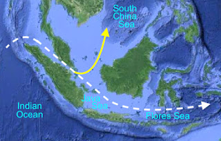
• Sorenson: “If Nephi’s vessel continued through the Java and Flores Seas of modern Indonesia, the westerly winds from December to March could have taken it past those areas within the first year of the trip. This route is most likely, although there are other possibilities.”
Yellow Line: the path through Indonesia to reach the west coast of America, turning north through the South China Sea and then into the Philippine Sea and northward past Japan on the Kuroshio Current; Blue Area: the Java Sea and Yellow Area: the Flores Sea, two seas Sorenson wants to take (white dotted line) Lehi through as he states it: “this route is most likely”

Unfortunately, that is not very likely in a ship “driven forth before the wind,” since the wind direction and ocean currents coming off the South Pacific Gyre that blow and flow from the Pacific Ocean through Indonesia and into the Indian Ocean.
Yellow Line: Preferred course, to utilize the northern route to the Western Hemisphere past Japan on the Kuroshio current; White dotted line: Sorenson’s course for Lehi that would take him deeper into Indonesia where there are thousands of small islands hindering navigation and place him along a path to the Western Hemisphere against the Pacific Ocean west flowing currents

Response: One of the problems for people like Sorenson, is when they start drawing lines on maps, they need to know where the winds and currents are located on those maps. As an example, Sorenson talks about the Java and Flores Seas as Lehi passing through, however, that would place him far south of where he would need to cross the Pacific Ocean, and run him right into the South Equatorial Current (or Gyre) which runs from east to west in a counter-clockwise circle, blocking any chance for a ship “driven forth by the wind” to progress against it. In addition, any further north would run him into the southern arm of the North Equatorial Current running clockwise across the Pacific—either way, his only chance of getting across the Pacific is along the northern Kuroshio Current past Japan and across below the Aleutians and down the west coast of North America—a course finally discovered by the Spanish Galleons taking gold and treasure back from the Philippines to Mesoamerica or Mexico.
White dotted line: Sorenson’s path would take Lehi deeper into Indonesia where there are thousands of small islands hindering navigation and place him along a path to the Western Hemisphere against (Blue circle and lines) the Pacific Ocean currents

• Sorenson: “Since boats routinely had to be beached for repairs after storms, or to have their bottoms scraped, or to await favorable winds, it is reasonable to assume that Lehi’s party would have stopped from time to time on their journey through these islands.”
Response: Let’s look at these outrageous ideas one at a time:
• Boats routinely had to be beached for repairs after storms.
    First of all, this is a fallacious statement. Ships were beached for two reasons only: 1) Wreckage below the water line that had to be repaired; and 2) Careening, that is, scraping barnacles and slime off the hull.
    The British Royal Navy, well aware of the importance of removing fouling from the hulls of their men-of-war in the 18th and 19th centuries when “Britannia ruled the waves,” saw many of its captains, like James Cook land his ship Endeavour at a small harbor he found at the mouth of what he named the Endeavour River in Australia on his way around the world so that it could be careened (laid over on its side) and the hull repaired and scraped free of barnacles.
    Cook notes elsewhere in his journal that he was looking for a suitable location to careen the ship with the sole purpose of cleaning the bottom.  It has long been known that fouling on a ship’s hull greatly increases hull friction and slows the vessel down, making it more sluggish and less maneuverable. All ship hulls develop a biofilm or slime layer of weed, barnacles and other fouling on the typical ship hull at the very least, regardless of the bottom paint, covering or material used in construction, and this, combined with rough hull coatings, carries with it a fuel penalty of as much as 20% or more in speed, efficiency and maneuverability of the vessel.
The only answer to removing the slime from the ship’s hull if not in port and have available dry docks, is for careening or “heaving own” a vessel where the ship is grounded at high tide in order to expose one side of its hull for maintenance and repairs below he water line when the tide goes out.
    The problem, of course, is if not done well, the ship can tilt over too far, water rush in over the gunnels and flood the vessel, sinking it, which has been done numerous times in history with very experienced crews.
    A beach favored by ancient mariners for careening was called a “careenage.” It was also possible to do this in deep water, called “Parliamentary heel,” in which the vessel was heeled over in deep water by shifting weight, such as ballast, cargo, or even guns on warships—HMS Royal George was lost in 1782 while undergoing a Parliamentary heel.
    It is not that Sorenson mentions the tactic, for such maneuvers were performed in the early days of sailing before dry docks, far-flung ports, etc. But to expect Lehi’s family to have done such a thing is ludicrous, since an enormous skill coupled with extensive experience is required to careen a ship.
(See the next post, “John L. Sorenson’s Winds and Currents – Part IV,” for more of the erroneous ideas Sorenson has for the sailing of Nephi’s ship, the currents, winds, and course)