skip to main |
skip to sidebar
Continuing
with another comment from a new reader, evidently promoting his own book
“Finding Zarahemla,” to which we are responding and continuing with an
understanding of this entire Delmarva Peninsula that Franklin Reid claims was
the Land Southward.
Top Left: The peninsula—note how much
land there is beyond that is undefined and not collectable into a Land
Northward; Top Right: The peninsula divided between Delaware, Maryland and
Virginia, and described as “a flat narrow sandbar between the bay to the west
and the Atlantic Ocean to the east; Bottom: The marsh lands in the northern
Chesapeak Bay where Franklin places his narrow neck of land
The Delmarva Peninsula, originally known as the Delaware Chesapeake Peninsula or simply the Chesapeake Peninsula, acquired the name Delmarva shortly after 1859, but did not become widespread until the 1920s, is an
irregular coastline of drowned river valleys, streams, and creeks. The
terrestrial landscape is topographically low and consists of vast areas of
poorly drained silty soils and well-drained sandy soils. Large tracks of tidal
marsh now blanket former forests and fill former streams and creeks, creating
lowland swamps, floodplains, low terraces and inundated river valleys.
It might also be of interest to
know that during the last Ice Age, mile-thick glaciers stretched as far south
as Pennsylvania, and the Atlantic coastline was about 180 miles farther east
than it is today. Approximately 18,000 years ago, the glaciers began to melt,
carving streams and rivers that flowed toward the coast. Sea level continued to
rise, eventually submerging the area now known as the Susquehanna River Valley.
This drowned river valley became the Chesapeake Bay, which assumed its present
shape about 3,000 years ago (about the time of the Jaredites). Remnants of the ancient Susquehanna River still
exist today as a few troughs that form a deep channel along much of the Bay's
bottom. To fully define the Chesapeake Bay ecosystem, we must go far beyond its
shores. Although the Bay itself lies entirely within the Atlantic Coastal
Plain, its watershed includes parts of the Piedmont Plateau and Appalachian
Province.
Even so, the west coast of Dalmarva
has continually expanded and receded over the past three thousand years,
including the separation of islands from peninsulas, such as Tilghman Island
(Great Choptank) which formed only in the period not long before John Smith
discovered the area. In fact, just over 3,000 years ago, when the Jaredires
would have landed, no one knows exactly what the Chesapeake Bay looked like, or
even if it had yet formed, or that it extended far enough northward to reach
Franklin’s narrow neck of land to set ashore in the Land Northward. And what
would have brought their barges, being driven strictly by wave action, into the
bay against strong tidal currents—a mixed wave and tide energy that created the
lower seventy miles of the Virginia Eastern Shore tail on the peninsula. Of
course, the same thing could be said for Nephi’s ship, “which was driven forth
before the wind”—how did they go against the winds and currents streaming down
the Chesapeak Bay to empty into the Atlantic Ocean? And how did they land when the western shore of Delmarva was far too shallow to broach in a deep sea sailing vessel?
Even today, the Chesapeak Bay channel
is so flattened “fill up” sediment that an ship has to pass through 11 man-made
channels to sail up the Bay; near the mouth the channels are filling with sand
from the ocean, near Baltimore they fill with sediment from the land, requiring
a constant dredging program to keep the Bay and channels open.

In fact, 3,100 years ago, certain to be the
time of the Jaredite landings, geologists tell us that much of this southern
extension did not even exist above sea level (“Bay Geology,” Chesapeake Bay Program,
2012, Anapolis, Maryland). The area is shallow, and even today deep water ships
cannot dock anywhere along this southern extension of the peninsula, and
sailing ships of the type coming in from the open sea can not sail along the
east shore beyond Cape Charles, which northward is limited to barge traffic.
How Nephi’s ship could have landed along the middle of the peninsula would be
an interesting question to try and answer, since these depths on a nautical
chart show anywhere from 1 to 4 feet moving into the peninsula side of the Bay
(National Oceanic and Atmospheric Administration (NOAA), Nautical
Chart #12224-Chesapeake Bay, Cape Charles to Wolf Trap).
The Atlantic Coastal Plain is a
flat, lowland area with a maximum elevation of about 300 feet. To fully define
the Chesapeake Bay ecosystem, we must go far beyond its shores. Although the
Bay itself lies entirely within the Atlantic Coastal Plain, its watershed
includes parts of the Piedmont Plateau and Appalachian Province. The waters
that flow into the Bay have different chemical identities depending on the
geology of where they originate. This coastal
plain is supported by a bed of crystalline rock covered with southeasterly
dipping wedge-shaped layers of sand, clay and gravel. Water passing through
this loosely compacted mixture dissolves many of the minerals. The most soluble
elements are iron, calcium and magnesium.
The coastal plain extends
westward from the continental shelf to a fall line that ranges from 15 to 90
miles west of the Bay. Waterfalls and rapids clearly mark this line, which is
close to Interstate 95.
Cities like Baltimore, Maryland;
Washington, D.C.; and Richmond, Virginia, were built along the fall line to
take advantage of potential water power generated by the falls. These cities
became important commerce areas, as colonial ships could not sail past the fall
line and had to stop to transfer their cargo to canals or overland shipping.
Since its formation, the Chesapeake Bay's shoreline has
constantly been shaped by tides and currents that erode the land and move
sediments to other parts of the Bay.
There are many examples of erosion and sedimentation
throughout the Bay. As an example, some geologists
estimate that the Calvert County, Maryland, cliffs Captain John Smith explored
in 1607 and 1608 have eroded back 300 feet. By the mid-1700s, forests were cut
down and turned into farm fields, which increased erosion and caused sediment
to fill some navigable rivers. Joppatowne, Maryland, was once a sea port, but
is now more than two miles from water.
In addition, many
Chesapeake Bay islands that existed during colonial times are now severely
eroded or completely submerged. In the early 1600s, Maryland’s Poplar Island
encompassed several hundred acres. By the 1940s, only 200 acres remained. Today,
the area is being restored using dredge material from Baltimore Harbor.
The
State of Delaware is located within two physiographic provinces, the
Appalachian Piedmont and the Atlantic Coastal Plain. Most of the state lies
within the Coastal Plain; it is only the hills of northern New Castle County
that lie within the Piedmont (foothills). Delaware’s rolling hills, north in
the Twelve-Mile Circle, which rise to over 400 feet above sea level, are a part
of the foothills of the Appalachian Mountains. The rocks at the surface in the
Piedmont are old, deformed, metamorphic rocks that were once buried in the core
of an ancient mountain range. This range formed early in a series of tectonic
events that built the Appalachians between about 543 and 250 million years ago.
During an early event, called the Taconic orogeny, an offshore chain of
volcanoes collided with the ancient North American continental margin to push
up a gigantic mountain range that was as tall as the Alps or the Rockies of
today.
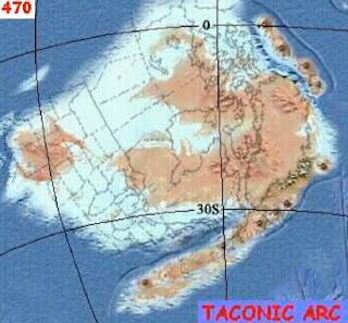
Geologists
date the Taconic orogeny between 470 and 440 million years ago. The Taconic
orogeny is important to our understanding of the geology of Delaware, because
during this event, the rocks of Delaware’s Piedmont were deeply buried under
miles of overlying rock and metamorphosed by heat from the underlying mantle.
Since that time, rivers and streams have carried the erosional products, mostly
sand, clay, and gravel, from the mountains onto the Atlantic Coastal Plain and
continental shelf. As the mountains wear down, the buried rocks rebound and
rise to the surface. Thus what we see in the Piedmont today are old, deformed,
metamorphic rocks that were once buried deep within an ancient mountain range.
Today, these mountain ranges are far out to sea.
(See the next post,
“Looking for Zarahemla-Part IV,” for more information on Franklin Reid’s book Finding Zarahemla, and his comments to
us and our responses, and also and introduction into the Dalmarva Peninsula to
show how it simply does not fit the scriptural record)
Continuing with another comment
from a new reader, evidently promoting his own book “Finding Zarahemla,” to
which we are responding and continuing from his last comment: “When the great emigration of the Nephites to
the land northward occurred, described in Alma 63:4-5, it was a very large
group that traveled overland through the narrow neck to move on to a better
place.”
Response (cont): When we start talking about immigration by
ship as opposed to overland, there are a couple of things to keep in mind. 1)
Purpose, 2) Motivation, 3) Practicality, 4) Convenience, 5) Cost, and 6)
Opportunity.
Obviously, the purpose of these immigrants mentioned in Alma
63 and Helaman 3, had to do with dissatisfaction with the lengthy war that just
ended between the Nephites and Lamanites, with their motivation looking for a
more peaceful and isolated land northward. As for practicality, it was a simple
matter of reaching Franklin’s Elk Neck area (narrow neck of land), less than 100
miles from his Zarahemla to the passage into his Land Northward.
Looking
north from Franklin’s narrow neck area to the east and north of the Chesapeake
Bay up Elk River; Bottom: Beyond the narrow neck at White Hall and Glasgow,
looking north. Note the completely flat ground—it would have been an easy trek
into his Land Northward from the Delmarva Peninsula with no narrow passage in sight
A rather simple task, and at the same time quite convenient.
The cost of overland travel would have been minimal and the opportunity after
the war ended quite convenient. Going by ship, on the other hand, which in this
circumstance makes no sense at all, would have been quite costly and much more
difficult in securing passage, and conveying by ship all the necessary
supplies, equipment and building tools needed. Typically, in ancient times,
immigration by ship was taken when large bodies of water precluded overland
travel—in this case, there would have been no water hindrances, nor mountains
nor any terrain nor topography blockages, making ship travel completely
unnecessary.
Also note in the photos above showing the narrow neck area,
there are no narrow passes between these two lands that Franklin claims is the
narrow neck of land. It is about 12 miles wide with nary a hindrance,
pass—narrow or otherwise—into the land beyond.
Top: The
area of Franklin’s Narrow Neck of Land, a small area between the Delmarva
Peninsula (south) and Pennsylvania (north), beyond Newark and Wilmington in the
Twelve-Mile Circle of Delaware; Bottom: Eastern lock of the Chesapeake and
Delaware (C&D) Canal in Battery Park, Delaware City, Delaware. Note how
flat the Narrow Neck area is—no hills, mountains, canyons, passes, etc.
To get a better picture of Delaware, it is on a level plain,
with the lowest mean elevation of any state in the nation, with Delmarva, the
entire peninsula falling within the Atlantic Coastal Plain, a flat, sandy and
sometimes swampy area with very few or no hills and a maximum elevation of
about 102 feet (447 in the continental or mainland of Delaware), and within the Mid-Atlantic Coastal Plain, which stretches for
239 miles along the coast and includes Eastern Maryland from the Anacostia
River (separating Maryland from Washington D.C.) eastward, Delaware, and New
Jersey (an area 12,168 square miles). Within Delmarva, or the peninsula, the
highest point is only 102 feet above sea level at Stillpond Neck, about ten
miles south of the Susquehanna River mouth on the east shore of the Chesapeake.
It is only 5,721 square miles and runs north and south 170 miles, though the
lower one-third is a narrow land neck about 50 miles long and 18 miles wide which,
today, belongs to Virginia, and known as the Virginia "Eastern Shore."
The actual narrow neck of land, between the Elk River (at White
Hall just south of Elkton) and the Delaware River at the mouth of Red Lion
Creek (between Newcastle and Delaware City) is only 12 miles wide over flat,
uninterrupted ground—hardly the day and a half journey for a Nephite described
by Mormon. Nor is it a choke point, since the area just south of there would allow
for a crossing of the Elk River, a distance of only 480 yards (less than five
football fields) across between Henderson Point and Plum Point, and further
south about 520 yards between Elk Forest and Bull Minnow Run—ether one of which
an army of attacking Lamanites or Nephite defectors could cross in canoes,
rafts or small boats, to gain a six mile wide finger of land that opens six
miles northward into a vast open land hundreds of miles across that would be
impossible to defend.

Looking
north up the Elk River at Town Point, (yellow arrow) about 600 yards across. The
river narrows to under 500 yards about 3 miles (white arrow) beyond this point.
Note the flat land all around
This Elk River north of Back Creek is not deep, being part of
a tidal tributary of the Chesapeake Bay
and the most northern extension of the estuary, which is only 1.4 miles long
between Elkton and the Chesapeake Bay. Beyond that, the streams run out of the
Piedmont (foothills) of the Blue Ridge Mountains (about 2,000 to 4,000 feet
elevation at this point) and the Shenandoah. The waterway itself is shallow,
shoaling very quickly beyond Elkton anciently, but in the late 1800s, was
dredged to a depth of 7 feet, and in 1915, dug out even deeper to about 14 ½
miles north of the mouth. To the south, the river to Back Creek is crooked and narrow in places, making it
difficult for any type of vessel Hagoth built to have traversed.
Your
Blog Comment: “The location is completely
different from any other theories you may have read about but, as you will see,
it is very compelling.”
Response:
It can hardly be compelling when it lacks so much in comparison to the
descriptions Mormon gave us. Truly, there is no narrow neck of land, just a
narrowing of the land that is flat with no narrow passage or pass, no military
choke point that could easily be defended with bows and arrows and swords, and
at 12 miles, could easily be crossed in less than a day. There is no specific
Land Northward, no mountains of any kind in the Land Southward, let alone ones
"whose height is great"; there are no two animals that would not have been known
to a New England farmer in 1829; no two grains; no natural herbs to remove
fevers; no west, east or north sea beyond the narrow neck; no Land of Many
Waters in the vicinity of the Land Northward; of the five or so main rivers in
the Land Southward (Peninsula), none flow northward as the Sidon River does.

In
addition, according to the Chesapeake Watershed Archaeological Research Foundation,
of the officially searched 1500 archaeological sites on the Peninsula, the
60,000 acres of agricultural fields and over 600 miles of Chesapeake Bay
shoreline and Atlantic coast line personally searched by the Foundation no
evidence of substantial human populations occupying this Middle Atlantic
coastal plain has been found. Even after numerous excavations and scores of
years of the Smithsonian and other professionals, not a single indication of an
ancient highly advanced culture exists; nothing beyond stone arrow points,
knives and tools have been located, with most archaeological finds centering on
shapes and designs of stone arrowheads, knives and tools, with a few ceramics,
lithics (rocks), and bone tools.
This is hardly evidence of an advanced culture, which the Nephites coming from Jerusalem in 600 B.C. would have been.
(See the next post,
“Looking for Zarahemla-Part IV,” for more information on Franklin Reid’s book Finding Zarahemla, and his comments to
us and our responses, and also an introduction into the Delmarva Peninsula to
show how it simply does not fit the scriptural record)
Continuing with another
interesting comment from a new reader, evidently promoting his own book
“Finding Zarahemla,” to which we are responding to the comment that the
Delmarva (Delaware/Maryland/Virginia Peninsula):
Your Blog Comment:
“On the east side of America is a large peninsula, about the size of Palestine,
with a sea east and a sea west with a narrow neck of land at the north end
connecting it to the mainland."
Response: First of all, Palestine is only 2,402 square miles, whereas Delmarva is 7847 square miles in size—perhaps you meant Israel, which is 5,454 square miles, both of which are considerably smaller than Delmarva. Secondly, your Sea
East is legitimately made up of the Atlantic Ocean and the large mouth of the
Delaware River, which in ancient times, would have been a singular sea to early
inhabitants. However, your West Sea is an ever narrowing Chesapeake Bay that
likely would not have been along the east coast (the mainland or Maryland/Virginia) since it is far too shallow to have landed on the west coast of Delmarva—yet, the scriptural record says they landed on the west coast in the south, which could not have happened on the peninsula. Again, however, this bay as it extends northward along the entire
length of your Land Southward (the entire Peninsula), narrows to as little as
2.8 miles wide.

As can be seen in the image (left), the blue line is Franklin's narrow neck of land, just south of which Hagoth built his shipyard. Why he would have sailed north is questionable, however, people would not have had to sail northward, they could have (white arrow) walked into the Land Northward and into a huge empty land; or (green arrow) could have crossed the 2.8 mile width of the river in a raft, no need for "an exceedingly large ship," and entered this vast land in which to immigrate; or crossed downriver (yellow arrows) where the far coast is less than five miles. It would simply not make sense to build a huge ship to sail up a small river when access to the area was so readily available all along the coast.
In addition, it is highly unlikely that the Nephites would have
built their major shipyards in this far northern bay which is like a river at
this point, and even more unlikely they would have sailed northward from there
up the Susquehanna River, when they had so much other areas to explore and
immigrate to in the west across this narrow water at this point, into Maryland’s mainland.
Why immigrate by ship when you could walk there and not have to go far at
all—just across the narrow bay to a huge interior land.
Your Blog Comment: “Hagoth built his ships and “they took their
course northward”
(Alma 63:6). How could they sail directly into the land northward? They
certainly couldn’t if we follow the Mesoamerica theory that they sailed west
along the coast of Mexico until they finally could go north. If we look at the
Delmarva Peninsula we see “launched it forth into the west sea, by the narrow
neck which led into the land northward” (Alma 63:5) That is the Chesapeake Bay
and at it’s north end is the opening of a very large river, the Susquehanna,
which is as large as the Mississippi at it’s widest. It goes directly into the
land northward and then bends east to enter central Pennsylvania.”
Response: There is no
question about not being able to sail north from Mesoamerica’s narrow neck of
land or the Isthmus of Tehuantepec; however, your site has its own, very huge
problems. First of all, as already asked, why would Hagoth build “exceedingly large ships” to
sail up a narrow river? That makes no
sense at all. An exceedingly large ship built at that point would have sailed
southward into the huge bay or out into the Atlantic and up the east coast,
perhaps, but not up a narrow river as you proclaim?

Top: The Chesapeake Bay across from the
Franklin’s narrow neck of land. Note the northeast branch river, the
Susquehanna River, where he says Hagoth’s “exceedingly large” ships would have
gone; Middle: The mouth of the Susquehanna River where it empties into the
Chesapeake Bay. Upward the river flows against the movement of the ships going
north. Note how quickly it narrows to a very limited sailing width; Bottom: The
Susquehanna upriver. Note how narrow the river becomes for an “exceedingly
large” ship
The mouth of the
Susquehanna River (Len’api Indian “Sisa'we'hak'hanna” meaning “Oyster
River), ”where it empties into the Chesapeake Bay is at sea level, and from
there it runs up the north branch 464 miles to Otsego Lake in Otsego County,
New York. One of its tributaries is the West Branch of the Susquehanna, which
runs west at Northumberland, just above, Sunbury, to Carrolitown in Cambria
County, Pennsylvania. It is claimed this river, like the Hudson and Delaware
and Potomac rivers, was well established in the flat plains of eastern North
America during the Mesozoic era.
The Susquehanna Canal was only four feet
deep in the beginning, but it allowed passage of larger ships, usually barges
and coastal merchants
Unfortunately for
Franklin’s idea of using the Susquehanna to move Hagoth’s people upriver, the
Susquehanna has many rapids which impeded northward and westward movement—while
commercial traffic could navigate down the river in the high waters of the
spring thaws, nothing could move up river! Two different canal systems were
constructed on the lower Susquehanna to bypass the rapids, one called the
Susquehanna Canal (Conowingo Canal or Port Deposit Canal) completed in 1802
running northwest from Philadelphia, the other was the longer and more
successful Susquehanna and Tidewater Canal, running northwest from the
Chesapeak Bay. Additional dams were required to raise the river and canals to
allow for larger commercial vessels—meaning large ships, especially Hagoth’s
“exceedingly large” ships. Both areas would have stopped Hagoth’s ships less
than a handful of miles from where they were launched. Also, we need to keep in
mind, that the Susquehanna like all eastern seaboard rivers, flows down to the
ocean or Gulf, it would have been impossible to sail ships in Nephite times up
any of these rivers, let alone get over the low, but mountainous areas
inland—as an example, when building the Susquehanna Canal, loaded barges were
transferred from the canal and hoisted across the mountain ridge into the
Pittsburg area.
The problem with
ideas like this is that they don’t work in the pre-industrial era of America
where the Corps of Engineers and other, earlier private groups, dug canals and
channels to allow ocean sailing vessels inland into the American interior as we
have shown in various articles of every sea lane from the Gulf of Mexico to the
eastern seaboard running inland from the Gulf or Atlantic Ocean. You couldn’t
sail where sailing wasn’t possible beyond a handful of miles from the coast all
over the southern and eastern U.S.
Your Blog Comment: ”It is like Mormon said, “nearly surrounded
by water” except for the narrow neck. This peninsula doesn’t show in any of our
maps because it is in three states: Delaware, Maryland, and Virginia. It is the
Delmarva Peninsula.”
Response: Of course
it shows on all maps. It is not labeled Delmarva, because it includes three states:
Maryland, Virginia, and almost the entire state of Delaware—but it is there on
the map and is very definitely a peninsula with no separate or separable Land Northward.
Even on maps we have in the West, the State
of Delaware appears, and does so on a peninsula, which is very noticeable on
all of the maps above that were randomly picked off locally available maps. Even if the
map is small (red arrow) or very old (bottom right)
Theorists have not
missed this peninsula, it is just that it does not fit the criteria of the
scriptural record and, therefore, has not been considered by anyone besides
you, and while that is not a deterrent, the fact that it doesn’t match Mormon’s
descriptions causes it to be overlooked by others.
You Blog Comment: “When the great emigration of the Nephites to
the land northward occurred, described in Alma 63:4-5, it was a very large
group that traveled overland through the narrow neck to move on to a better
place.”
Response: Exactly. In
fact, there is so much area north, northwest, and even northeast from your
narrow neck, why immigrate by ships at all? Vast tracks of land would have been available just beyond the narrow neck in any direction. This is not what Mormon described, nor does your narrow neck fit the descriptive information about it in any way, from being too narrow to having no strategic purpose, to not keeping an enemy from circumventing it and moving into the land northward beyond this so-called neck.
(See the next post,
“Looking for Zarahemla-Part III,” for more information on Franklin Reid’s book Finding Zarahemla, and his comments to
us and our responses, with continuation of the above last paragraph)
We received another interesting comment from a new
reader, evidently promoting his own book “Finding Zarahemla,” to which we are
responding:
Comment: “In my own book, "Finding
Zarahemla" available on Amazon, I explain how the Mesoamerica theory can't
possibly be right. The land southward exists on the east coast of the U.S.as it
is described by Mormon in Alma 22:32-33. He describes it is a peninsula, with
no land bridge to the south. Looking at a modern map, this peninsula is about
the size of Palestine and has a sea east and a sea west with a narrow neck
(12-15 miles) at the north end. It was important that the Lamanites be
"hemmed in" in the south with no place to go according to verse 33. Our
problem is that most LDS people in the U.S. are westerners and know little or nothing
of east coast geography” Franklin R.
Response: I
really think “our problem” is that many members of the Church do not spend
enough time reading the scriptures before trying to decide where the Land of
Promise might have been located. It seems anyone with a map can look for a
peninsula, a narrow neck, the hill Cumorah, or whatever, and decide that has to
be the place. In addition, it might be suggested that people in the west know more about geography than is suggested—we are a traveling people out here and have been to the east numerous times, while those in the east seldom come west, but vacation to the south along the eastern coast.
Let us respond
to a few of your points first, then we will get into the geologic foundation of
your premise about the Delmarva Peninsula, referred to as Delmarva—a
name taken from the three states DELaware,, MARyland, and VirginiA. Today it is
technically an island, but only because of the digging of the Chesapeake and
Delaware Canal, finished in 1829—before that it was strictly a peninsula. As such, it is 170
miles long and from 70 to 12 miles across or wide. While the lower half borders the
Atlantic Ocean on the east, the upper half borders the Delaware Bay and Delaware River on the east, both of which have been dredged to allow for ocean vessels to penetrate to Philadelphia. Delmarva is separated from the mainland on the west by
the Chesapeake Bay, which is only 2.8 miles wide at its narrowest and 30 miles
at its widest.
1. Your
Comment: “I explain how the Mesoamerica
theory can't possibly be right.”
Response: This
is absolutely true. Mesoamerica, as we have been pointing out for six years in
this blog, and in our four books on the subject, simply does not match the
scriptural record and cannot possibly be the Land of Promise.
2. Your
Comment: “The land southward exists on
the east coast of the U.S.as it is described by Mormon in Alma 22:32-33.”
Response: First of all, there is
no mention of or reference to the United States or that area the U.S. occupies
in the American Continent. Second, let’s quote the scriptures referenced: “And now, it was only the distance of a day
and a half's journey for a Nephite, on the line Bountiful and the land Desolation,
from the east to the west sea; and thus the land of Nephi and the land of
Zarahemla were nearly surrounded by water, there being a small neck of land
between the land northward and the land southward. And it came to pass that the
Nephites had inhabited the land Bountiful, even from the east unto the west
sea, and thus the Nephites in their wisdom, with their guards and their armies,
had hemmed in the Lamanites on the south, that thereby they should have no more
possession on the north, that they might not overrun the land northward”
(Alma 22:32-33). Note the term: “small
neck of land” (which Mormon also calls “narrow neck” in Alma 63:5)—now this
neck lay between and connected to two land masses of greatly
larger sizes; the Land Northward—designated by Land of Desolation—and the Land
Southward—designated by Land of Bountiful (Alma 22:31). We find that the Land
Southward was, indeed surrounded by water except for a narrow neck of land that
led further northward into the Land of Desolation and north of that, the Land
of Many Waters which contained the land of Cumorah and the hill Cumorah (Mormon
6:4).

Third, the problem is, that while
the scriptures tell us the Land Northward was also surrounded by water,
Franklin’s map and location do not allow for such a thing, requiring him to
change the scriptural record which reads: “And it came to
pass that they did multiply and spread, and did go forth from the land
southward to the land northward, and did spread insomuch that they began to cover
the face of the whole earth, from the sea
south to the sea north, from the sea west to the sea east” (Helaman 3:8,
emphasis added). Now the term from sea to sea is not used except when those
seas are not only extensive, but also cover entire seaboards or surround entire
land masses.
As
an example, we talk about the United States running “from sea to shining sea,”
but not in both directions, only from east to west (including the southeast and
a portion of the south). On the other hand, in Australia, the term from sea to
sea and from sea to sea would make sense. In Canada, which has sea surrounding
the country on three sides and a coastline of 164,988 miles, compared to a land
border of only 5,525 miles (Contiguous U.S. and Alaska), has as a motto: “A Mari Usque Ad Mare,” which is “from
sea to sea.”
If
that is not sufficient to say that the Land Northward was also surrounded by
water, then consider Jacob’s statement in the temple speaking to the Nephites
when he said: “we have been led to a better land, for the Lord has made the sea
our path, and we are upon an isle of the sea” (2 Nephi 10:20). The word “isle”
in Joseph Smith’s time meant “island,” a word which was not in use then.
The
point is, though Franklin wants to use a peninsula to indicate his model, there
is no suggestion or use of the term peninsula in the scriptural record. The only
term ever used is "isle" meaning “island.”
3) Your Comment: “He describes it is a peninsula, with no land
bridge to the south”
Response: Mormon does not
describe the Land of Promise as a peninsula—he is describing only the Land
Southward as being surrounded by water except for the narrow neck. However, as
shown above, the entire scriptural record, when using all of the scriptural
descriptions, shows we are dealing with an island, where there is a north, east
and west seas for the Land Northward, as well.
Top Photos: Islands in the midst of the sea as Jacob describes; Bottom
Left: An island in the midst of the see with a narrow neck separating two
larger masses; Bottom Right: Island showing labels that would match the Land of
Promise descriptions of a Land Northward, a Land Southward, a narrow neck of
land, four seas and an inlet sea that divides the land
Your Comment in Book: “I have just looked at the
simple facts as recorded in the text,” and also “Admittedly, I am taking much
of it very literally and fully accept what has been said in these scriptures.”
Response:
One of the problems always associated with Heartland, Great Lakes and other
eastern U.S. theories is that they do not match the scriptural record
descriptions, no matter how much the author might lay claim to doing so, as
Franklin does above. Take, for instance the simple statement made by Samuel the Lamanite, a
prophecy the Lord put into his heart, “there shall be many mountains laid low,
like unto a valley, and there shall be many places which are now called valleys
which shall become mountains, whose height is great” (Helaman 14:23).

The
reality is, that the highest elevation anywhere in Delaware is 447.85 feet
above sea level as shown by the Ebright Azimuth across from Tower Hill--and that is not even on the Delmarva Peninsula where the highest point is 102 feet. There
are simply no mountains on the entire
peninsula, your entire Land Southward, and nothing higher than 102-feet in
elevation. Thus, this cannot be the Land of Promise location based upon a very
simple statement made in Helaman of a prophecy the Lord placed in his heart for Samuel the Lamanite “prophesied unto the people whatsoever things the Lord put into his
heart” (Helaman 13:4).
The
point is, if you are going to give more than lip service to “I have just looked at the simple facts as
recorded in the text,” then you need to respond to such statements with
logical and conclusive evidence, otherwise your argument comes off extremely
weak, and you are left with having to ignore or change the meaning of other parts of the
scriptural record.
(See the next post, “Looking for Zarahemla-Part II,”
for more information on Franklin Reid’s book Finding Zarahemla, and his
comments to us and our responses)
When Joseph Smith
began the translation of the plates, he started with the Book of Lehi, which translated
into 116 pages of hand-written manuscript. Scribe Martin Harris, in trying to
relieve at least curiosity of his wife and family, and the ridicule from
Palmyra’s tavern crowd, he sought to borrow the manuscript to help provide “a
further witness of their actual existence and that he might be better able to
give a reason for the hope that was within him” to his wife and family. When
these pages were lost, the Lord directed Joseph to translate from the “small
plates” Nephi made and abridged his record upon “for a wise purpose in him,
which purpose I know not” (1 Nephi 9:5).

Consequently, as most
every member knows, in the Book of Mormon, as we have it today, the record of 1
Nephi was written by Nephi, who had included a brief abridgement of his
father’s record. Thus, we have a very incomplete record of Lehi, and know so
little about this stalwart prophet. But Lehi is more than a “typical” prophet.
And despite the fact that we do not have much information about him we can
discover Lehi himself gives one key to his character.
When Sariah,
supposing that her sons had “perished in the wilderness or at the hands of Laban,” accuses Lehi of
being a “visionary man.” Lehi agrees: “I know that I am a visionary man; for if
I had not seen the things of God in a vision I should not have known the
goodness of God, but had tarried at Jerusalem, and had perished with my
brethren” (1 Nephi 5:24).
Dreams and visions (1
Nephi 8:2) seem to have dominated Lehi’s life; he was called by the Lord in a
vision in which he saw Christ and the twelve apostles (1 Nephi 1:6-14). In
another prophecy he foretold the Babylonian captivity, the ministry of the
Messiah, and the preaching of the gospel to the gentiles (1 Nephi 10:3-14). Even
the journey into the wilderness was commanded in a dream (1 Nephi 2:1-3). In
other dreams Lehi was commanded to send his sons back to Jerusalem to obtain
the plates of Laban (1 Nephi 3:2-4), and later to persuade Ishmael and his sons
and daughters to join them (1 Nephi 7:1-2).
When his sons
returned with the plates of Laban, the first thing the patriarch did was to “offer sacrifice and burnt offerings unto
the lord; and they gave thanks unto God of Israel” (1 Nephi 5:9), for the safe
passage of the sons and their return.
It
was only after that act of faith and devotion that Lehi was willing to satisfy
his curiosity toward the records the Lord deemed so important for him to have.
He then “took the records which were engraven upon the plates of brass, and did
search them from the beginning” (1 Nephi 5:10-11).
Lehi was not the only
prophet of his time whose name the Old Testament has forgotten. Nephi says that
just prior to his father’s call “there came many prophets, prophesying unto the
people that they must repent, or the great city Jerusalem must be destroyed” (1
Nephi 1:4). These were among the messengers of God that the Bible tells us were
“mocked,” their messages “despised,” and themselves “misused” (2 Chronicles
36:16-19)
No prophet who sees
beyond the immediate situation to the fall of a nation is ever popular with the
people of that nation; and most of the time, unfortunately, he is ignored.
Numerous Old Testament prophets found themselves in that position, and many of
them were stoned or otherwise killed by the Jews (1 Thessalonians 2:14,15;
Matthew 23:37; Acts 7:52).
In the midst of his
preaching (1 Nephi 1:18), because the Jews became angry with him for pointing
out their wickedness and prophesying of the coming of the Lord, they sought his
life (1 Nephi 1:20). The Lord had something else in mind, however, and told Lehi
to take his family and depart into the wilderness (1 Nephi 2:2), and he never
wavered. Now Lehi was a wealthy man, with gold, silver and many precious
things, but being obedient (1 Nephi 2:3) he left it all behind (1 Nephi 2:4)
and headed into the wilderness as told.
There is an
interesting parallel between Lehi’s performance and that of members in our day.
When the Saints were driven out of Nauvoo, they came west, following their
leaders who the Lord directed. Because of their faithfulness and obedience, the
Church survived the persecutions and mob attacks and settled in a far away land
(the territory of Utah) where it could worship as they chose and build up the
kingdom. Like Lehi, they didn’t ask why they had to leave their comfortable
homes, secure setting and sheltered lives—they took what they could carry and
left everything else behind.
It might be of
interest today to compare such action with the typical attitude sometimes
displayed by the younger generation of members today who seem to feel they need
to know “why.” One such individual told me recently, “Look, we live in the
information age—we want to know the what, where, when and why of everything.”
The halls of Wards
today seem to echo with the questions: “Why did the Church change their stance
about the Priesthood?” “Why can’t children of gay marriages be baptized?” “Why
are women denied the Priesthood?” etc., etc., etc. I was asked recently what my
favorite scripture was, and though I have many, my all-time favorite and has
been since I first studied it, is Amos 3:7: “Surely the Lord God will do nothing, but he revealeth his secret until
his servants the prophets.”
It seems in my
generation, when asked to pack up and leave, we did it. It also seems in
today’s generation, there is a hesitancy and a desire to know “why must I?”
Perhaps I am mistaken in this, but it certainly seems to be the case.
Lehi, however, didn’t
ask anything. He didn’t hesitate, or need any further information. He simply
left his wealth and comfort and fine home and headed into the wilderness. In
this case, the wilderness was a barren desert.
The Negev, a Hebrew word meaning “dry,” is a
rocky desert that runs along the Sinai desert, full of wadis, box canyons, deep
craters, tall sand dunes and loess (wind-blown dust); to the other side is the
Arava Valley, the hottest, southern stretch of the Arabah, 103 miles in length
from the Dead Sea to the Gulf of Aqaba—it was through this area Lehi took his
family
Lehi’s reliance was on the Lord alone, and he turned from a
dangerous and important task of preaching repentance to the Jews, to pursue an
even more dangerous and important task. No longer would he try to change a
nation. Now he would create one; he would raise up a righteous people for the
Lord.
Lehi’s family had always been important to him, but now his
entire calling focused on his children and their children. His own sons and
daughters were his mission, with no distractions. And suddenly the role of
patriarch and the role of prophet became one role. It was for the benefit of
“his seed” that he was commanded to send his sons for the plates of Laban (1
Nephi 5:19), and when he asked Ishmael and his family to share the journey, he
was choosing the mothers who would help shape his righteous progeny (1 Nephi
7:1-2).
At the end of his life, when he learned in a vision that
Jerusalem had been destroyed, he did not mourn for the city he had loved and
served so well. Instead he reminded his children that they lived in “a land of
promise, a land which is choice above all other lands” (2 Nephi 1:5). He had
been a prophet to his family, and he was satisfied (2 Nephi 1:14-15).
The stature of Lehi as the Prophet and leader of the Family
was never in question. Nephi makes that clear in no
matter how close he himself came to the Lord, the revelation that dealt with
where the family should go came to Lehi. The Lord spoke to Lehi “by night, and
commanded him that on the morrow he should take his journey into the wilderness”
(1 Nephi 16:9).
The “ball of curious
workmanship” that directed them on their way appeared before Lehi’s tent (1
Nephi 16:10). When Nephi’s bow broke and he made another to keep the group
alive, he went to his father to find out where he should go to get meat (1
Nephi 16:23-26, 30-31). And though the Lord spoke to Nephi to command him to
build a ship (1 Nephi 17:8), Lehi received the Lord’s direction to enter it and
begin the voyage (1 Nephi 18:5).
When his wayward sons
rebelled, Lehi rose to lovingly correct them. He understood their murmuring
nature (1 Nephi 3:5), but never lost hope for his two older wayward sons (2
Nephi 1:17,19), and held out hope for them to the end (2 Nephi 1:24), but he
did not excuse their wayward behavior and rebellious nature, warning them of a
possible future that awaited them (2 Nephi 1:29) if they did not change.
Lehi was the perfect
example of a father, servant and leader. One we could all emulate.
When Nephi
and his brothers returned from Jerusalem after obtaining the Brass Plates from
Laban and with Zoram in toe, Lehi and Sariah were both comforted, especially
Sariah who had envisioned the death of her sons at the hands of her relative,
Laban. While he was a
notable citizen, probably one of the prominent elders of Jerusalem at the time,
who commanded great wealth and many servants, who had in his charge the brass
plates that the Lord wanted Lehi to obtain, he was not a righteous man,
but dishonest, and suffered from avarice in obtaining wealth not his own.
He had custody of the
brass plates that Lehi's sons were to retrieve. He was killed by Nephi at the
command of the Lord (1 Nephi 4:10) when Nephi found him in a drunken stupor on
the streets of Jerusalem. Ironically, the imposing sword Laban carried to
impress his fellow elders became a symbol of leadership and was wielded in
defense of freedom by a number of Nephite leaders later in the Land of Promise.
While Lehi and Nephi
were people shaping the events of their lives, others, like Sariah, Sam and
Zoram were more ordinary people, being caught in events rather than shaping them,
people striving to be righteous when overpowering forces weighed against them, people
whose social status may be akin to our own, though their experiences themselves
may differ. As an example, Sariah was caught in the fear of what had happened
to her four sons after their lengthy separation while the four boys went back
to Jerusalem to obtain the Brass Plates from Laban.
Lehi’s visions and
revelations gave him strength to leave “the land of his inheritance, and his
gold, and his silver and his previous things,” taking only his family tents,
and provisions into the wilderness (1 Nephi 2:4). But not everyone who followed
him was blessed with dreams; most had to trust Lehi’s vision. Laman and Lemuel
were complaining by the time the group reached its first camp a few days’
journey into the wilderness.
While Lehi did not
express doubts, he intensely desired to know the mysteries of God, saying: “I
did cry unto the Lord; and behold he did visit me, and did soften my heart that
I did believe all the words which had been spoken by my father; wherefore, I
did not rebel against him like unto my brothers” (1 Nephi 2:16).
Sariah was obligated
to move with her husband; there is no evidence that she was less than
supportive during the move, but neither is there evidence that she received
visions. She seems to have given up her comfortable surroundings and more
important her kinfolk, without complaint—but giving up her sons was more than
she thought she could bear.
The trip back to get
the brass plates may have taken the boys more than a week. The meetings,
plotting, scheming, travel down to get Lehi’s wealth and return up to Jerusalem
and then the escape from Laban’s servants, the encounter with Zoram, etc., may
have taken a few additional days, and the final trip back to Lehi’s tent in the
wilderness another week or so. All in all, we are looking at upwards of three
weeks or more—a long time when one fears the consequences of the separation and the
difficulty of the task at hand.
Both Lehi and Sariah
must have known something about the unrighteousness of their kinsman Laban.
Surely Sariah had good cause to worry for the safety of her sons. Lehi
comforted her, not by promising that they would not face difficulties in their
journeys, but by pointing out that those who stayed in Jerusalem would perish.
Then he bore testimony that God would deliver his sons “out of the hands of
Laban” (1 Nephi 5:5).
The importance of
these brass plates is found in what they contained:
• The five books of
Moses (the Jewish Torah);
• A history of the
Jewish people, down to the reign of [then current] King Zedekiah;
• The prophecies of
the Israelite prophets down to Jeremiah, seen in the Book of Mormon as a
contemporary of Lehi; and
• A genealogy of all
the tribes of Israel including a genealogy of Lehi's own ancestors, revealing
him to be a descendant of Joseph, son of the patriarch Jacob.
After reading the contents of the
brass plates, Lehi prophesied that they would "never be dimmed any more by
time," and that they would ultimately "go forth unto all nations,
kindreds, tongues, and people" who were of his seed.
It is understandable when Sariah
complained as she faced the potential loss of some, or all four of her sons (1
Nephi 5:1-3). She had just traveled the distance between Jerusalem and the
Valley of Lemuel and knew exactly when her sons should be returning. Her
husband was a wanted man in Jerusalem-which might possibly lead to danger for
her sons as well.
Considering these coupled with the fact that losing her sons
would cause others to think she was cursed by the Lord, and she’d have no one
to care for her in her old age or defend the family name, we begin to
understand her desperation. She loved her sons, and her grief for their
potential demise was valid. The delay of her sons’ return tested Sariah as
never before. Yet, the Lord knew that this was an important trial of faith for
her to go through. She would need to face even harder trials in the years to
come
It is
likely that Lehi, who was undoubtedly a merchant and traveled about (1 Nephi
1:7), and probably his sons, would have been experienced at traveling and
living in a tent, but not Sariah or her daughters.
Coming from a wealthy home with servants, they would not have been experienced
at taking on the demands of desert living. At the same time, it is most likely
that the household had servants and possibly household slaves who cooked
meals and handled much of that type of activity, and certainly because of the
degree of secrecy in their leaving, would have been taken along on the journey. Likely, Ishmael’s wife
and daughters were probably in the same situation, though it is unknown what
kind of wealth, if any, Ishmael would have possessed.

It
should also be kept in mind that the tents of the period were large and bulky,
made of camel skin, and contained at least three rooms with hanging rugs
between and others to cover the ground. It is claimed that to carry the poles it would take
one donkey (there were no camels in Jerusalem because of the sharpness of the
rocks and shale on the ground atop the mountain that would have cut into the
soft padding of the camel hoof), another to carry the rugs and interior, and a
third donkey to carry the tent itself.
There
also would have been cooking utensils and other household goods to be carried,
as well as whatever provisions they took and their seeds of every kind.
There
seems little doubt that living out of a tent would have been a rather frightful
time, since living in the Arabian wilderness offered many challenges: intense
climate, endless rolling sands with scarcity of water, and peril from wild
animals. Children and grandchildren suffered from lack of food and water, hostile
Arabian tribes who thought nothing of murdering for gain would have threatened
at every turn—especially when they reached the Rub’al Khalil sand desert and
the Lord told them to use no fire that would have attracted Beduin thieves and
marauders.
She gave birth to at least two sons, Jacob and Joseph, in their eight-year sojourn in the wilderness, and possibly two daughters, for Nephi had two sisters by the time he fled from his brothers with those who would go with him (2 Nephni 5:5). Indeed, her life was a difficult one but the only complaint she seems to have uttered was when she thought she might have lost her sons to Laban's evil nature.
But
even more unsettling, the lack of love between her two older sons and the
younger two would have been devastating for Sariah. She was also faced with a
difficult choice, if she was alive at the time, after her husband passed away.
Nephi, was commanded to flee from Laman in order to preserve his life (2 Nephi
5:5). Nephi took all those who believed in the “warnings and the revelations of
God” (2 Nephi 5:6). Sariah was in this category and it would have been a
difficult experience for her to say goodbye, permanently, to her two oldest
sons, their wives, and all of those grandchildren.
We
don’t know how long Sariah lived or whether she witnessed the conflicts between
the people of Laman and the followers of Nephi that seemed unending. But we do
know that Sariah followed a prophet into the wilderness and spent many long
years living in harsh, difficult, and deplorable conditions.
Yet
from the shores of the Red Sea to the hills of the Land of Promise, her
testimony remained firm as she did indeed testify, “Now I know of a surety that
the Lord hath commanded my husband to flee into the wilderness” (1 Nephi 5:8).
Sariah, by her living and nature, is an example of faith and obedience and one after whom we could all pattern our lives.


