Thursday, November 24, 2016

More Comments from Readers Part V

More comments and questions from readers of the blog: 
    Comment #1: “Sorenson claims that the Jaredite final battle was really only a war among two familes and not universal to all Jaredites. That means that there could have been Jaredites that were not destroyed—who lived on into Nephite times, contrary to your opinion” Ken J.
    Response: Sorenson promotes the continuation of the Jaredite people as Hugh Nibley did before him for the simple reason that their Mesoamerican model demands other people exist in the area besides Nephites; however, when he says some didn’t take part, we need to remember that when Shiz ran before Coriantumr, they evidently passed through several populated areas because his army “swept off the inhabitants before them, all that would not join him” (Ether 14:27).
Ether dutifully recorded the history of the Jaredites to be later included into the history of Lehi and the Land of Promise. Ether was a prophet to the entire Jaredite Kingdom, not a couple of small families

    It should be noted there is a noticeable difference between gathering together everyone in the land and just a portion of the people. Moroni makes it clear that at the end, Ether wrote that “And it came to pass that Ether did behold all the doings of the people; and he beheld that the people who were for Coriantumr were gathered together to the army of Coriantumr; and the people who were for Shiz were gathered together to the army of Shiz. Wherefore, they were for the space of four years gathering together the people, that they might get all who were upon the face of the land, and that they might receive all the strength which it was possible that they could receive. And it came to pass that when they were all gathered together, every one to the army which he would, with their wives and their children -- both men, women and children being armed with weapons of war, having shields, and breastplates, and head-plates, and being clothed after the manner of war” (Ether 15:13-15).
    However, when just a family or smaller group was involved, Moroni made that clear as in the case of Akish demanding the family swear allegiance to him and his planned evil deeds (Ether 8:13), and when Morianton gathered together an army, it is singled out as not everyone, but just “an army of outcasts” (Ether 10:9). But when talking about the Jaredites as a whole, it was all, everyone, and “they did gather together all the people upon all the face of the land, who had not been slain, save it was Ether”(Ether 15:12).
    It is amazing that Sorenson clings so doggedly to a belief of Jaredite survival that he ignores all the references to the total Jaredite destruction.   
    Comment #2: “Are you suggesting that when Mosiah discovered Zarahemla, that he merely followed one of the Nephite roads to the north and down into the Land of Zarahemla?” Jon J.
    Response: No. There likely would have been no roads built in that direction beyond the Sacred Valley, such as a road from Cuzco over to Urubamba and on to Ollantaytambo, and another from Cuzco over to Pisac and along the Urubamba River from Pisac to Ollantaytambo.
    Comment #3 “The record states that when Lehi turned and traveled east across the desert, they lived on raw meat in the wilderness. However, under the dietary laws of the Jews, they were not permitted to eat raw meat. More specifically, they could not eat meat that had visible blood in it, and they could not drink the blood (Genesis 9:4 and Deuteronomy 12:23). How do we justify this conflict?” Carlos R.
Response: The meat that Lehi’s family ate in the wilderness was probably dried and cured like jerky, which the Lord “made sweet” tasting. There would have been no blood yet it was not cooked over a fire. In the scriptural record, the term “raw meat” is used by Nephi when he writes: “that while we did live upon raw meat in the wilderness, our women did give plenty of suck for their children, and were strong, yea, even like unto the men; and they began to bear their journeyings without murmurings” (1 Nephi 17:2). While we, today, tend to associate raw meat with a slab of uncooked meat or barely cooked meat as in a steak, etc., the term raw meat means only that it was not cooked. Uncooked meat in the wilderness is often jerked, that is, raw meat that is cut into strips, salted and dried in the sun—generally it is tough and hard to chew; however, the Lord evidently softened that of Lehi’s raw meat that it “nourished them and did strengthen them” (1 Nephi 17:3).
    Comment #4: “You appear to be negative about a United States only Land of Promise. Why is that?” Adrian H.
    Response: Partly because the scriptural record shows an initial landing where the winds and currents die down along then 30º south Latitude of the Chilean coast, an area today called then Bay of Coquimbo and La Serena. From there immigrants in Hagoth’s ships traveled north, and we find a well-developed civilization in Central/MesoAmerica, and from there we find a spread of at least Lamanite culture moving further north into North America.
Joseph Smith in Zion’s Camp receives a visions regarding the White Lamanite Zelph and the prophet Onandagus known from the sea to the Rocky Mountains

    In the U.S. we find the story of Zelph and Zion’s Camp, and the prophet Onandagus, including Joseph Smith’s letter to his wife, Emma, making comment about the Plains of the Nephites in the area. Taken as a whole, we find that all of the North and South America being the overall and total Land of Promise, with parts of it dedicated to certain groups, such as the Jaredites and the promise to Lehi and his posterity in the more southern portion, i.e., South America; North America being the seat of the Church and world government from which Christ will reign, etc.
    Also because of:
1. Joseph Smith stated “…speaking of the Land of Zion, It consists of all N[orth] & S[outh] America” (Martha Jane Knowlton Coray, edited by Dean C. Jessee, “Joseph Smith’s July 19, 1840 Discourse,” Brigham Young University Studies 19:3 (Spring 1979), p. 392. Four years later, in 1844, Joseph added, “The whole of America is Zion itself from north to south” (Teachings of the Prophet Joseph Smith p362; Doctrines of Salvation, vol 3, 1956, pp73-74).
2. Orson Hyde in referring to the Land of Promise stated: “This land means both North and South America, and also the families of islands that geographically and naturally belong and adhere to the same” (JD 7:108).
3. B.H. Roberts who said, “…these two American continents [North and South]. These continents are a promised land.” (History of the Church, p552fn)
4.Wilford Woodruff said, “This land, North and South America, is the land of Zion; it is a choice land—the land that was given by promise from old father Jacob to his grandson and his descendants, the land on which the Zion of God should be established in the latter days.” Journal of Discourses (12 January 1873), 15:279.
5. Pres. Spencer W. Kimball said, “Zion was all of North and South America, like the wide, spreading wings of a great eagle, the one being North and the other South America” (Conference report April 1975, 7U, pp31-33).
6.  Ezra Taft Benson added: “This is our need today—to plant the standard of liberty among our people throughout the Americas…the struggle for liberty is a continuing one—it is with us in a very real sense today right here on this choice land of the Americas” Conference Report (October 1962), pp. 14–15; and according to Ezra Taft Benson, this included North America and South America (The Teachings of Ezta Taft Benson, 1988, p123)
7. Bruce R. McConkie, a member of the First Council of Seventy for 26 years, and a member of the Quorum of the Twelve Apostles for 13 years, said, “The Americas are the land of Joseph—the land of Ephraim and Manasseh, the land of the Nephites, the land of the Ephraimites who are gathering in the latter days.”
Also, Nephi he saw in a vision “I looked and beheld a man among the Gentiles, who was separated from the seed of my brethren by the many waters; and I beheld the Spirit of God, that it came down and wrought upon the man; and he went forth upon the many waters, even unto the seed of my brethren, who were in the promised land” (1 Nephi 13:12). This man, Columbus, never saw or set foot on North America, but only Central and South America and the islands of the Caribbean.
    There is much more, including the descriptions in the scriptural record simply do not match the Land of Promise a Great Lakes theory shows or any other Heartland or U.S. model.

Wednesday, November 23, 2016

More Comments from Readers Part IV

Comment #1: “What was the value of the defensive wall when it had openings, even if they were wooden doors or gates that were barred. Such can be overcome. Seems self-defeating to me” Victor E. 
The several stone doorways in the zig-zag walls surrounding the northern approach to Sacsahuaman

    Response: I remember feeling much the same way when I first saw those doorways, since there are six of them, two each in each wall on each of the three levels. I never understood their rationale of building such fantastic impregnable walls only to leave these openings, though it would have been the only way from inside of the complex out the back to the open field where numerous activities, rituals and ceremonies took place anciently. I tried to consider how any door could be braced to make it impenetrable and nothing came to mind until I read Garcilaso de la Vega, who grew up among the still-intact Sacsahuaman complex of cut stones. He wrote that each of the gates were operated like drawbridges by lowering or lifting a huge stone into place. Evidently, during attack, they were lowered into place from the inside, and evidently could not be moved from the other side.
Comment #2: “You write about the zig zag walls of Sacsahuaman, but without guns to cross-fire, I don’t see what advantage or purpose this achieved” Phil G.
    Response: The original 60-foot high zig-zag walls provided twenty-two salient (outward) and re-entrant (inward) angles on each level. An enemy would have to expose their flank to the defenders as they tried to scale the walls, which was the main way of attacking walls anciently, either by ladder or by hand. The zig-zag provided a field of fire for sling, bow and arrow, stone, and bricks—the weapons of the early Peruvians.
    Comment #3: “If those Inca roads were truly built by the Nephites, why would Nephites have built roads between Zarahemla, their homeland in Mosiah’s time, and the city of Nephi, in Lamanite hands?” Bronson E.
Response: Not until the time of the so-called Nephite Golden Age, 34 A.D. to about 200 A.D., would roads have been built to connect the north and the south of the narrow strip of wilderness. First of all, it seems likely that the first section of roads in the famous road system was constructed around the City of Nephi (Cuzco) connecting it to Shilom, Shemlon, Chanapata, and the surrounding areas the Nephites would have built during that period of time between when Nephi settled there and when Mosiah left, a period of at least 350 years. This no doubt included building up the Sacred Valley to Ollantaytambo and possibly as far north as the area of Machu Picchu (though doubtful it would have been up the mountain to the city, just to the area).
    The roads to Tiahuanaco, Puma Punku, Lake Titicaca (beyond the La Raya Pass) might also have been built at this time. One of those roads was an average of 15-feet wide, with sections of these first roads paves with flat stones and other roads just hard-packed earth. Low stone walls on either side of the road market the way, and in sections of steep inclines steps were formed or cut directly into the stone. In addition, some of these roads were cut through the solid rock of the mountain, and no doubt some of the rope bridges were strung across gorge and deep river ravines. These roads were probably not completed until around 29 or 20 A.D. when “many highways [were] cast up and many roads made which led from city to city and from land to land, and from place to place” (3 Nephi 6:8).
    Comment #4: “If I understand you correctly, you divide or separate the land of Nephi from the rest of the land south of the narrow strip of wilderness. Why and to what extent?” Rob P.
Response: As Mormon wrote, the Lord brought Mulek into the Land North and Lehi into the Land South, (Helaman 6:10), Lehi’s family would have called that land where Lehi landed the Land of Lehi, and it was evidently so labeled in the first 116 pages that were lost. Nephi’s people obviously called the land where he settled after separating from his brothers, the Land of Nephi. When Mosiah left that land to settle in Zarahemla, the Lamanites took over the city of Nephi and that land and added Lehi to the name, thus we see the City of Lehi-Nephi later (Mosiah 7:1).
    Consequently, the original Land of Nephi probably would have been bounded by the Cordillera Vilcasbamaba on the north, by the cordillera Carabaya on the east (with the Vilcanota waters running within the borders parallel to the Carabaya). The southern border would have probably been at the area formed by the Mountain knot called the Vilcañota Knudo, an area that now separates the department of Cuzco from the Titicaca Basin by way of the La Raya Pass. The western boundary would probably have been the gorge of the deep Apurimac River, a tributary of today’s Amazon River.
    Comment #5: “I understand Hagoth built his first ship around 55 B.C. for some immigrants that sailed into the land northward and this was done “on the borders of the land Bountiful, by the land Desolation” (Alma 63:5). I assume from this that it means the land Bountiful and the land desolation had a common border. If this is true that means one or the other land included the narrow neck of land. Is that right?” Luke P.
Response: That is a good question since there is nothing in the scriptural record to clarify this point. My personal take on it is that the narrow neck of land was a narrow corridor (Pass) between the two lands in the same way that the narrow strip of wilderness is described as being between the Land of Zarahemla and the Land of Nephi; however, this is merely my opinion since it is not specified one way or the other in the scriptural record. What we know is that Hagoth’s shipyard was near the narrow neck of land, which we have shown elsewhere was probably in the Mangrove islands to the southeast of the opening into the channel of the Gulf of Guayaquil.
    I might just clarify one point—we do not know that the first ship listed in Mormon’s abridgement was the first ship Hagoth built. As a shipwright, Hagoth may have built other, and probably smaller, ships before this event; however, it sounds like this was the first of a very large type ship he built since such emphasis is placed on the “exceedingly large” size.
    Comment #6: “Doesn’t Isle of Sol in lake Titicaca suggest that the Inca and early Peruvians worshipped the sun?” Dion D.
    Response: The Isle of the Sun is a modern name, just as the Temple of the Sun and the Temple of the Moon at Pachacamac area. It is just as likely that the island could have been called in pre-Inca times as the Isle of the Son since a temple was built there. Archaeologists today, normally not steeped in religious beliefs or attitudes, tend to make everything about nature and nothing about God in ancient peoples.
    Comment #7: “The story of Lehi does not ring true to me from all I have read and seen of Arabian sheiks” Juanita W.
    Response: Arabian Sheikhs (Shekh) held a rather unique place in the ancient world. And Lehi is depicted quite accurately. While he lived, the relationship between him and his family as described by Nephi is actually accurate in the smallest detail. With the usually deft sureness and precision, the record shows Lehi leading—not ruling—his people by his persuasive eloquence and spiritual ascendency alone, while his murmuring sons follow along exactly in the manner of Harry St. John Bridger Philby’s description of the Bedouins—“an undercurrent of tension in our ranks all day...great difficulty to appease their evil, envious souls…”
Philby (left) describes leaving one village with “all of us in the crossest of humors…so out of temper were my companions, that at sunset, of the whole party only one would eat supper, while the rest sat upon the ground, pouting and grumbling…Such a game at naughty children I have seldom seen played even by Oriental men.” In fact, the character and behavior of Laman and Lemuel conform to the normal patter. How true to the Bedouin way are their long bitter brooding and dangerous outbreaks! How perfectly they resemble the Arabas of Lawrence, Douthty, Burton, and the rest in their sudden and complete changes of heart after their father has lectured them, fiery anger yielding for the moment to a great impulse to humility and an overwhelming repentance, only to be followed by renewed resentment and more unhappy wrangling!
How much more accurate can you get? It is as though Joseph Smith lived half his life in Arabia among the Arabs and Hebrews of the desert.

Tuesday, November 22, 2016

More Comments from Readers Part III:

Comment #1: “You refer to the mountains of the land of Promise, yet the scripture calls them hills—maybe they were just hills after all and their height was not so great like mountains in the eastern U.S. are much smaller than mountains in the western U.S.” Herb F. 
Top: Photo of hills; Middle: Mountains in the background hills in the foreground; Bottom” Mountains
 
    Response: It is interesting in the Spanish language the word Cerro, which is used by map makers for mountains refers to volcanoes, which by their nature, are high mountain peaks. It is also interesting that in South America, maps all show mountains as ranges (cordilleras) and individual peaks by the word cerro, which literally translates as “hill,” though some are many thousands of feet high like Cerro Cayambe, a 19,160-foot high volcano in Ecuador—such map designation using “cerro” dates back to at least 1490-1533. In addition, the Hebrew word for mountain is הָ֫רַר “harar,” which is used for either “mountain” or “hill” or “mount,” literally meaning “to loom up.” Of the 12 occurrences where “harar” is used in the Old Testament, ten are translated “mountains,” and two are translated “hills.”
    In the 1828 American Dictionary of the English Language, we find that “hill” means: “A natural elevation of land, or a mass of earth rising above the common level of the surrounding land; an eminence. A hill is less than a mountain, but of no definite magnitude, and is sometimes applied to a mountain. Jerusalem is seated on two hills. Rome stood on seven hills.” Thus, in South America, then we have Hebrew, Spanish and Book of Mormon using the word “hill” for a mountain peak not a hill like we do in English. Obviously, there is no question that the hill Cumorah in New York is a hill, barely 100 feet in height, which Cerro Imbabura (15,033-feet) in South America is definitely a mountain, with a 7000 foot prominence above anything around it.
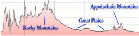
Difference in height of the eastern mountains, such as the Adirondacks, and the western mountains, such as the Rocky Mountains

    Comment #2: “You talk about the Nephite “Golden Age” but I’m not certain exactly when that was” Frank L.
    Response: There were really two points in the thousand year history of the Nephites when they achieved such remarkable periods in their history that were both unusual and high achievement moments. The first was the generation following king Benjamin’s speech in 124 B.C., which he delivered from a tower on the temple grounds. Following that speech, and the covenant the hearers made (Mosiah 5:7) the Nephites were called the children of Christ; his sons and his daughters; for behold, this day he hath spiritually begotten you, and found at the right hand of God (Mosiah 5:9), all of this when Mosiah was 30 years old, and began to reign following king Benjamin (Mosiah 6:4).
    The second period, and far longer one, was following the appearance of the Savior among the Nephites, beginning in 34 A.D., when the Nephites were called the Church of Christ (3 Nephi 26:21), and lasted four generations (3 Nephi 27:32), for approximately 176 years (4 Nephi 1:27-28) in which at least one of the generations not a single soul was lost (3 Nephi 27:31-32).
    During this time there were no "–ites" among them, they had all thing in common, there were no poor, and much was accomplished, for buildings were renewed, roads built, and many marvelous things accomplished.
    Comment #3: “How far was it from the city of Bountiful to the narrow neck of land?” Reilly N.
    Response: There is no indication in the scriptural record to suggest a definitive distance. On the other hand, even though not a single event in the scriptural record takes place between Bountiful and the narrow neck, you tend to get the impression that it was not a great distance. The movement of Morianton and his rebels toward the pass in the narrow neck of land suggests that, Moroni, who was in or around the city of Moroni near the border of the Lamanites (guarding that quarter of the land from Lamanite incursions), feared that if Morianton reached Bountiful, he might persuade the people there to join him in his rebellion (Alma 50:32). Thus, Moroni sent Teancum in charge of any army, to head off Morianton from reaching the city of Bountiful, or more importantly, the narrow neck of land which they could then gain the land beyond (Alma 50:29) and guard it against Moroni’s army, creating a second front for the Nephite military to defend (Lamanites in the south and Morianton in the north).
Teancum cut off Morianton short of the narrow pass through the narrow neck of land to the north of Bountiful

    So Teancum took his army, possibly stationed in or around the city of Nephihah, along with its camp (Alma 50:33), which would have included supplies, tents, provisions, etc., for a lengthy march and action.
    We are not told whether or not Morianton reached the city of Bountiful, or was even headed there. We know only that Morianton reached the southern borders of the Land of Desolation (Alma 50:34), with Teancum and his army reaching the narrow pass before Morianton and his rebel army. This narrow pass, which leads “by the sea, on the west and on the east” would have been a singular choke point, for being so narrow, a small group of men could have held off Teancum’s army had Morianton reached the pass first.
    Comment #4: “I’ve heard a lot of odd stories and jokes about the name Sacsahuaman. Do you know what the name means, and just exactly how do you spell it?” Florence T.
Left: Falcon; Right: Variable Hawk

    Response: According to Diego Gonçález Holguín (Vocabulario de la Lengva General de todo el Pero llamada Lengva Qquichua o del Inca, Francisco del Canto, 1608, p26f), the name is variously spelled: Saksaywaman, Saqsaywaman, Sasawaman, Saksawaman, Sacsahuayman, Sasaywaman, Saksaq Waman, or hispanicized spellings Sacsayhuamán, Sacsayhuaman, Sacsahuaman, Saxahuaman and others. When taking a tour of Sacsahuaman, the guides usually draw attention to the sound alike “Sexy Woman,” but the Quechuan word “waman” means “falcon” or “variable hawk” (a bird of prey in the Accipitridae family of South America).
    Comment #5: “If the Nephites built Cuzco, why is its construction credited to the Inca?” Scott E.
    Response: When Cuzco was first discovered and being discussed, the early historians and archaeologists knew about the Inca that the Spanish conquered. It seems that it was a convenient way to describe everything. Since then, archaeologists and anthropologists have discovered there were many “cultures” and peoples that occupied the Andean area, including Cuzco, long before the Inca period. However, once a thought gets into the public conscience, it is difficult to change. In addition, the tourism industry of Peru and the Andes seemed to think that “Inca” ruins, “Inca” roads, “Inca” everything had a good sound to it and even though it has since been shown to be others who built these areas, the term “Inca” has been long and erroneously repeated.
Ruins of a newly discovered 3-squasre mile temple complex at the edge of the Sacsahuaman complex that long pre-dates the Inca

    In fact, many parts of Cuzco long pre-date the Inca period; with, according to John Howland Rowe ("An Introduction to the Archaeology of Cusco, Papers of the Peabody Museum of American Archaeology and Ethnology, Harvard University vol 27, no 2; also Rowe, "Inca Culture," B.A.E. 21:200), claiming the Kilke culture is credited with building portions of the city around 900 A.D. However, some archaeologists date Sacsahuaman back into B.C. times.
    Comment #6: “I find it interesting that when the Lamanites came down to attack the Nephites in the city of Desolation that the Nephites were victorious and killed a great many Lamanitres, yet they had just been driven out of the land southward” Dean B.
    Response: No doubt the sudden change in elevation had something to do with this. The city of Desolation would have been at sea level (Mormon 3:5-6), at least right there in the narrow neck area. Evidently, land to the south where the Lamanites were located was at a much higher elevation, since they “did come down to the city of Desolation” (Mormon 3:7). In this area in the Land of Promise, the elevation south of the narrow pass is 7,000 feet, an obvious deterent to fighting, suddenly at a level 7,000 feet different in elevation. The reverse of this is also seen when the Nephites “began to boast in their own strength” and “did go up” to battle the Lamanites, the Nepihites were handiy defeated and driven back to their own lands (Mormon 4:1-2).

Monday, November 21, 2016

More Comments from Readers - Part II:

More questions and comments we have received from our readers: 
    Comment #1: “It seems that the Lamanites and Nephites had numerous wars, it appears they were always battling each other” Sandra W.
    Response: That is probably because of the condensed history we have. However, in Jarom, we find a clue that these wars were probably annual, when the weather broke and the winter passed and the grounds dried up and marching an army across the land was feasible. Jarom wrote: “And it came to pass that two hundred and seventy and six years had passed away, and we had many seasons of peace; and we had many seasons of serious war and bloodshed” (Omni 1:3).
Now the word “season” has two meanings: 1) a season of the year, such as spring, summer, etc., and 2) a period of time. The 1828 American Dictionary of the English Language defines this definition of season as: “A fit or suitable time; the convenient time; the usual or appointed time,” “a time of some continuance, but not long.” Either way, it would appear that these wars covered a period of time of the year, but not the entire year, meaning not ongoing. Wars in genera, especially during the early history of the world, have been fought during the seasons or periods of time when the weather was conducive to moving troops and supplies. Few winter campaigns have been successful, as first Napoleon and then Hitler found out when attacking Russia. Thus, it would appear that the Lamanite-Nephite wars spoken of in the scriptural record occurred during one period of time each year (probably late spring and summer) and then broke off because of weather changes, rain, snow, etc., to pick up again when the spring came. On the other hand, there were a few occasions when the wars did not continue for a few to several years. As was the case in all ancient situations, warfare was closely bound to the natural environment and ecology: weather, altitude, terrain (geography), food supply, seasonality, and agricultural cycles.
    Comment #2:  “You are right in that the text reads "we are living upon an isle of the sea."  It is my interpretation that the Nephities, or at least some of them, were still living on the Isle of the Sun in Lake Titicaca when Jacob inscribe the passage.”
    Response: This statement was made in answer to a comment about Jacob’s statement in 2 Nephi 10:20.
    First of all, the Isle of the Sun is a rocky, hilly island in Lake Titicaca with eucalyptus trees, no paved roads, and is a farming community with several terraced  hills, including today about 800 families. Of the several villages, Yumani and Ch'allapampa are the largest. There are about 80 ruins on the island, all dating to the Inca period, though archaeologists have discovered evidence that people lived on the island as far back as the third millennium BC. According to Inca legend, the Isle of the Sun was one of the most important Inca shrines, with pilgrimages rivaling that of Pachacamac.
    The problem with the assessment of this being what Jacob had in mind is to ignore what Jacob actually said. First of all, Jacob is standing in the Temple, i.e, the Temple Nephi built like unto Solomon’s, he is speaking to the bulk of the Nephite people who had gathered at the temple for a two day conference, this being the second day, in which Jacob says, “the Lord has made the sea our path, and we are upon an isle of the sea” (2 Nephi 10:20).
 Isle del Sol in the midst of Lake Titicaca

    Thus, we see that the Nephites in total were living on the island at the time of Jacob’s comment, and that the island Jacob mentions is one within the sea over which the Lord led Lehi to the Land of Promise. Therefore, it could not be an island within a lake. Jacob then goes on to say, “But great are the promises of the Lord unto them who are upon the isles of the sea; wherefore as it says isles, there must needs be more than this, and they are inhabited also by our brethren” (2 Nephi 10:21), showing that other islands would not just be other islands within the lake, for certainly Jacob and the Nephites would have known of this, but Jacob refers to their island like other islands unknown to them, again suggesting islands in the sea or oceans.
    Flippant answers like this submitted comment are far too often an unthinking, simple, unknowledgable response to a serious and important question when the theorist doesn’t believe that the Nephites were on an island in the first place.
    Comment #3: “What do you think of Rod Meldrum’s comment that “nowhere in the Book of Mormon does it state that they sailed east in their ship or that they landed on the west coast of the promised land” Jayson M.
    Response: I wonder how he explains away that Mormon describes the area of First Landing of Nephi as being “and they were spread through the wilderness on the west, in the land of Nephi; yea, and also on the west of the land of Zarahemla in the borders by the seashore, and on the west in the land of Nephi, in the place of their fathers' first inheritance, and thus bordering along by the seashore” (Alma 22:28). The idiom “Father’s First Inheritance” carries a significant meaning in Hebrew, akin to “are first occupied,” etc.
    Comment #4 “Did Hagoth settle Mexico or do you think his ship was lost at sea? My guess is since these were Nephites they did not settle North in Mexico and the language is so much different that it tends to prove that they weren't related to the Mayan. But what is your opinion?” Ira T.
Response: First of all, there is no suggestion Hagoth ever sailed anywhere—we only know he built ships, and while one ship was at sea, he was building another (Alma 63:7). Secondly, this is well outlined and covered in our book Who Really Settled Mesoamerica, and in short, when those Nephites “who did enter therein and did sail forth with much provisions, and also many women and children; and they took their course northward” and “the first ship did also return, and many more people did enter into it; and they also took much provisions, and set out again to the land northward” (Alma 63:5,7). Since these people were never mentioned again in the scriptural record, even when Mormon was running for his life with the Nephi Army throughout the Land Northward, one might suggest they went elsewhere—which is why they were never heard from again. Add in that a similar culture and civilization cropped up in Mesoamerica around the first century B.C., when Hagoth’s ships are said to have sailed northward, it might be suggested that these were also Nephites, who occupied Mexico and Central America. And when Joseph Smith talked about the Nephites and Lamanites in North America that he discovered, we can then assuredly know that, as modern prophets have time and again said, the Western Hemisphere is the Land of Promise. It began with Lehi landing in Chile and Nephi occupying the northern area, specifically Peru and later Ecuador, then spread northward by ship, and finally into North America, all the prophecies, all the rhetoric of the various Theorists, come together. As for the language, we don’t know what the Nephites in Mesoamerica underwent in their history, or whether there was a repeat of those who were righteous and those who were not splitting into two groups once again, and an annihilation of Nephites occurred elsewhere. At some point I am hoping that is all clarified for us.
    Comment #5: “It seems to me that an explanation of the lost 116 pages should have been included in the Book of Mormon somewhere in the beginning for those who read the book for the first time, as I just did, would understand why it starts with Nephi’s comments and not his father’s, which are alluded to later” Jack V.
Response: It is interesting you mention that—no one else has ever brought that up to us. However, in the original first edition of the Book of Mormon, Joseph Smith felt that a preface was necessary to address the loss of those 116 pages of the Book of Lehi. It stated: “As many false reports have been circulated respecting the following work, and also many unlawful measures taken by evil designing persons to destroy me, and also the work, I would inform you that I translated by the gift and power of God, and caused to be written, one hundred sixteen pages, the which I took from the Book of Lehi, which was an account abridged from the plates of Lehi, by the hand of Mormon; which said account, some person or persons have stolen and kept from me, notwithstanding my utmost exertions to recover it again….”  This preface is not included in any other edition.

Sunday, November 20, 2016

More Comments From Readers – Part I

Here are more comments from readers of our blog:   
Comment #1: “Why do we have a 3rd and 4th Nephi when they are not connected to the author of 1st and 2nd Nephi? Seems odd to me” Sandra H.
Response: You might be interested to know that in the original Book of Mormon and up until 1879, there were no books or sections labeled 3rd and 4th Nephi. Instead, they were called “The Book of Nephi, The Son of Nephi, Which Was the Son of Helaman” and “The Book of Nephi, Which Was the Son of Nephi, One of the Disciples of Jesus Christ.“ In 1879, when Orson Pratt divided the Book of Mormon into what is now our current chapters and verses,   “III Nephi” and “IV Nephi” were added to these titles for clarification.  In 1920, they were again revised to “Third Nephi” and “Fourth Nephi.”
    Comment #2: “The thing that convinced me that Sorenson was full of baloney is that Hagoth could not sail north from the Meso-America model. That clinched it for me” Ira T
    Response: There is no obvious answer to Sorenson’s way of thinking on this. He makes statements and ignores the reality of the scriptural record. In plotting out the actual figures, to leave I figured it out once, and the distances amount to a total of 855 miles total sailing before being able to turn northward.
First Red Arrow is traveling West by Southwest; second red arrow is traveling West by northwest; 855 miles before (purple arrow) a true northward direction could be achieved as Mormon informs us; Orange arrow shows a landing site in Sorenson’s Bay of Acapulco—his landing site for Hagoth’s ships that went northward, but according to Sorenson, landing before they could ever turn northward

    Both Alma and Mormon tell us that Hagoth’s ships “took their course northward” (Alma 63:6). Now, leaving the area of Sorenson’s Mesoamerican narrow neck, one would have to sail for 120 miles in a southwest direction, before turning West by Northwest, which is a westerly direction, to reach the State of Guerrero coast—which is 310 miles in a westerly direction, a direction that continues for another 400 miles before a ship could turn to a northwest heading. This is a total of 855 miles in a westerly direction from Hagoth’s launch site—in other words, as the white arrows show, Hagoth’s ship would travel 400 miles westward and only 35 miles northward to land at Sorenson’s Acapulco Bay, or 630 miles to the west and only 280 miles to the north before being able to turn northward.
    So once again, Sorenson claims something opposite of the scriptural record!
    Comment #3: “There are many strong arguments for the hill in New York being the Hill Cumorah, but the strongest of these arguments is that Moroni himself said it was. And another good argument is that it is a hill. Unlike Cerro el Vigia, one proposed hill in Mexico, the New York hill rises 220-230 feet from base to top. Cerro el Vidia stands 2,700 feet from base to top. A “hill” of 2,700 feet is a mountain and surely would have been described as such by Mormon. The “land of Cumorah”, is described as “a land of many waters, rivers and fountains”. The area around the Hill Cumorah certainly fits that description. New York, Pennsylvania and Ohio are home to nearly 400 lakes including the Great Lakes” Lyle M.
    Response: First, the hill Cumorah is not 230 feet high or higher. If you would go there and walk up it, you would find it is barely a bump on the plain. The State of New York lists the hill as being no more than 130 feet high. Secondly, this information you sent is evidently quoted from “JosephKnew.com, the Book of Mormon in America’s Heartland.” Third, the word “cerro” is Spanish, a word applied to almost any hill, mountain or peak by the Spanish when they arrived in Central and South America, as any old or current map will show you. Literally, “cerro,” means a) “hill,” as in subamos al cerro par aver las estrellas (“Let’s go up to the hill to look at the stars”); b) a “mountain” as in Situada en las faldas del cerro Santa Apolonia (“Located at the feet of the mountain Santa Apolonia”), or  Tengo un cerro de ropa para lavar (“I have a mountain of laundry to do”). On the other hand,”cerro” can also mean “ridge,” “to shut,” “close,” “heap,” or “back.”
The Vista del Cerro del Vigia, Manzanillo, Colima, Mexico—a view of the Hill Vigia in Mexico. Frankly, this does look like a hill and not a mountain

    The point is, the word “cerro” does not mean “hill” exclusively like we say hill in English. We do not call Mount Raineer, the Hill Raineer, but the Spanish do, etc. Third, as for “The “land of Cumorah,” it is described as “a land of many waters, rivers and fountains,” it actually is not. What Mormon says, is: “we did march forth to the land of Cumorah, and we did pitch our tents around about the hill Cumorah; and it was in a land of many waters, rivers, and fountains” (Mormon 6:4). That is, the Land of Cumorah, which is not described, is in a land of many waters” and doesn’t even say it was around the water, lakes or fountains. When the wounded Mormon looked out over the battlefield the next day, he does not mention anything about lakes, rivers, or fountains—only the dead bodies.
    Nor can it be said, as so many Great Lakes people claim, that Moroni called the hill Cumorah in New York the hill mentioned in the scriptural record in the Land of Promise. For more on this, see our post: Wednesday, December 30, 2015 “America is the Land of Promise—But Where is America? – Part XIV.”
    We need to be careful that we read what is written, not what we think is written.

Comment #4: “I was looking at a website recently showing the area where Panama and Colombia join as being the area of Bountiful, and the narrow neck of land just north in Panama. I don’t think I have read you commenting about that layout for the land of Promise” Brett J.
Top: The map location of the Land of Promise as seen by David Richens in his “Mapping the Book of Mormon” book. Bottom: The reality of this area is simply that it has always been a deep, impassable jungle, claimed to be the most dangerous place on earth. To look at a map and say this is where Bountiful was located is one thing, but to put it in the most inaccessible area in the Western Hemisphere is mere ignorance 

    Response: We have written about it several times, but the gist of it is this, that for a very long geological time, according to geologists, the area you speak of, called the Darien Gap, was (and still is) an impassable jungle that has caused a complete break in movement of any kind between Colombia and Panama—it is the only place in the 48,000-mile-long Pan-American Highway, which runs from Alaska to Tierra del Fuego in Argentina. Explorers have always been drawn to this Gap, beginning with the Spanish in 1510, but the results have mostly been disastrous. It is as wild today as it was in the days of the Conquest. Only a few tour-exploring groups operate in the area, along with some drug hideouts, and an occasional independent explorer attempting to make it across.
    The work of the Glomar Challenger research and scientific drilling vessel, which cored the seabed on both sides of the Panama isthmus at this very point, shows that this area was underwater and not even attached to South America at one time, and when it came up, it has been an impassable jungle ever since. Several attempts have been made to navigate through this area, all have met with failure until the twentieth-centuryh with GPS and 4-wheel drive vehicles, which still resists most attempts to make it through.
    The Gap stretches from the north to the south across Panama, from the Atlantic to the Pacific, and is between 80 and 100 miles, with the only way around it by sea.
    The website and maps you mention are evidently the ones from David Richens in his “Mapping the Book of Mormon,” posted in March 2016, in which he states that “In my post about Book of Mormon geography, I mentioned that I deliberately avoided looking at existing research while I was compiling the scriptural references and coming to my own conclusions. Later on I did a little bit of poking around online just to see what other people have been saying.” It might have done Richins some good had he spent some time researching the area he is mapping. He has placed his “Bountiful” right in the middle of the Darien Gap of Panama, an area where he not only has a city, but for as long as geologists figure, has been a swamp land that is simply impassable.
    For any researcher to even suggest such a thing is merely to show one’s ignorance of the reality of the places being discussed.
This map shows the cities along the Sea East seacoast are here shown along a northern seacoast off the Caribbean Sea of the Atlantic Ocean. And the line of march shown for Teancum to intercept Morianton’s flight northward (which on the map is mostly southward and then westward) would have taken Teancum and his army over a series of mountains (red dotted line)  so difficult to negotiate, tunnels were carved through them by modern engineers rather than try to build over them 

    We could go on about Richlins maps and theory, but it is so far from reality it hardly warrents the time.

Saturday, November 19, 2016

Evaluating the Deseret News Views of two Land of Promise Theories – Part II

Continuing from the previous post about Michael De Groote of the Deseret News who weighed in on the Land of Promise and evaluated what he considered the two most prominent theories, Mesoamerica and the Heartland. In the first post, his comments on some “random strengths and weaknesses from both theories” covered that of Mesoamerica. Below we will cover his views on the Heartland model. 
1. Heartland theory strengths—Promised land. "This is the promised land. The prophecies and promises indicate that the United States has to be at least some part of the Book of Mormon, because practically every one of these promises in it can only really be applied as the United States," Rod L. Meldrum said. "It is a nation 'above all other nations,' and a 'mighty' Gentile nation. Well, what other nation are they talking about here? I don't think that they are talking about Guatemala here."
Response: We have covered this time and again in the blog. Several prophets and General Authorities in General Conferences have discussed the entire Western Hemisphere as being the Promised Land, Zion, Land of Promise, etc. Lehi landed along the Chilean coast, Nephi moved northward into southeastern Peru, Mosiah I moved down into the Land of Zarahemla in west central Peru, and Ecuador was the Land Northward—we have also documented this numerous times in support of the Western Hemisphere being the land the Lord set aside for these last days. While the U.S. plays a very important role, beginning with the Monroe Doctrine of securing the rights and freedoms to the overall Land of Promise, that specific area given to Lehi within the Book of Mormon is limited to South America. It might be of interest to Meldrum and other isolationists who want the U.S. to be all of the Land of Promise, that Nephi tells us quite clearly that when he saw Columbus sailing to the Land of Promise that he “was separated from the seed of my brethren by the many waters; and I beheld the Spirit of God, that it came down and wrought upon the man; and he went forth upon the many waters, even unto the seed of my brethren, who were in the promised land” (1 Nephi 13:12, emphasis added). 
    Now, if Columbus, who never landed in North America, let alone the United States, sailed “even unto the seed of my brethren, who were in the promised land” we must conclude that the actual land of the Book of Mormon to which Nephi was seeing around 580 B.C., was not within the United States, yet it was the Land of Promise!
2. Heartland theory strengths—Joseph Smith statements. Joseph Smith made several statements throughout his life that indicate that he believed Book of Mormon events took place in North America.
    Response: He also made the statement that Lehi sailed southeast and landed in Chile at the 30º south latitude, a statement his scribe and secretary (as well as 2nd Counselor in the First Presidency) Frederick G. Williams wrote down. As Joseph repeatedly said, unless he was speaking for the Church he was merely stating his opinion like everyone else. He never issued any statement for the Church as to the location of the Land of Promise other than it being in the Western Hemisphere.
3. DNA. Journal studies of Native American DNA shows that the rare X DNA haplogroup is found in the parts of North America where the heartland theorists say the Book of Mormon took place. Although geneticists' dating of the DNA does not correlate with Book of Mormon times, the X DNA haplogroup has its origins in the Middle East, not Asia.
    Response: Until DNA can be shown to be without question as accurate as needed, and until this chronology of DNA can be shown to exist as so many people, like Meldrum, try to jump on the bandwagon to show, the jury is still out on this one.
4. Archaeology. North America has sites that date to the right time for the Book of Mormon and that match descriptions of fortifications.
    Response: This is simply not true. The fortifications found in the U.S. neither match the huge fortifications indicated in the Book of Mormon, nor include “resort” fortifications, nor stone walls around all the lands, etc., as Mormon describes, nor do they match the dates of the Nephites in anything that can be time dated by the means other locations in the Americas can.
5. Hill Cumorah. The Gold Plates were buried in the New York Hill Cumorah.
    Response: The Gold Plates were found in the Hill Cumorah in western New York by Joseph Smith who was told of their location by Moroni. It does not mean they were originally buried or hidden in that hill at the time of their last known location in 421 A.D. or shortly afterward. We simply have no record or idea of that.
6. Heartland weaknesses—River Sidon. “The Book of Mormon makes it abundantly clear that the river Sidon runs from the south to the north," Sorenson said. And in Alma 2, Alma and his army wade across the river to fight the invading Lamanites. The river Sidon in the heartland model is considered to be the Mississippi River.”
    Response: There is no place or area along the path of the Mississippi that matches the area of the land to the south of any location being higher. The U.S. Mississippi basin slopes from north to south and is a drainage basin, meaning it drains downhill toward the flow of the river. Yet in the Land of Promise, the land to the south of Zarahemla is higher, as is the draining of the Sidon, which flows northward.
7. Hills. There are hills in the land of Nephi. Sorenson said it is always described as "up" in relation to everything else. "Where is the 'up' (in the heartland model)? Is it the hills of Kentucky?" Sorenson said.
    Response: There are mountains in the Land of Promise, and in the Land of Nephi. These mountains, after the crucifixion, are so high, they are described as mountains “whose height is great,” by Samuel the Lamanite. There are no great mountains whose height is great anywhere in the middle or eastern U.S. in any of the areas claimed to be that of the Land of Promise. Meldrum's heartland covers the Great Plaisn of the U.S., the Mississippi Drainage basin, and the flat southern lands. The Great Lakes has no hills, let alone high mountains.
8. A West Sea. The Narrow Neck of Land has a west side on a West Sea. The border by the West Sea is where Nephi and Lehi and their party landed. If the West Sea is one of the Great Lakes, Sorenson wonders how Lehi sailed to it from Asia.
Response: There would have been no way to get to the Great lakes, or any other inland lake or sea anywhere in the middle or eastern U.S. The Mississippi north of Baton Rouge, the St. Lawrence west of Montreal, and none of the inland waterway systems could handle ocean-going vessels until dredged and deepened by the Corps of Engineers in the 18th century onward.
9. Climate. “Where is the snow in Zarahemla?" Sorenson asked. "Where is the snow in the Book of Mormon? Where is the cold in the Book of Mormon? Not a single word that indicates anything other than warmth and even tropical heat."
    Response. Actually, there are only two places in the entire scriptural record that suggests heat, when it states: “And there were some who died with fevers, which at some seasons of the year were very frequent in the land—but not so much so with fevers, because of the excellent qualities of the many plants and roots which God had prepared to remove the cause of diseases, to which men were subject by the nature of the climate” (Alma 46:40). The “heat of the day” is also mentioned (Alma 51:33). But it can also be deduced that the reason why after prolonged battles the Lamanites continually retreated and returned to their land and that can be seen by winter weather when throughout history armies have retreated before winter set in. And in each case, it appears the Lamanites did not return to battle until the following year, i.e., after the weather changed and spring or summer began. The point is, we know little about the weather and climate of the Land of Promise and for Sorenson or anyone else to make definitive conclusions from what little is written does little to expand our understanding.
10. Lack of Civilization. The evidence of the type of high civilization described in the Book of Mormon is less prevalent than in Mesoamerica.
Response: Actually, the highest civilization existed in South America, and steadily decreased the further north we go until in North America, there is little evidence of any civilization about the standard of the so-called American Indian.
    All in all, the article in the Deseret News does little to add to our knowledge of the location of the Book of Mormon. And for the newspaper to single out just two locations, leaving out South America that has so many matches and so few negatives is remarkably narrow-minded and slanted, especially when neither of those two locations match hardly anything found in Nephi, Jacob, Mormon or Moroni's descriptions of the Land of Promise.