Friday, April 24, 2020

Who Built Ñaupa Iglesia’s Mysterious Ruins in the Sacred Valley of Peru?

Showing the location of Cuzco and some of the surrounding sites, particularly in the Sacred Valley to the north

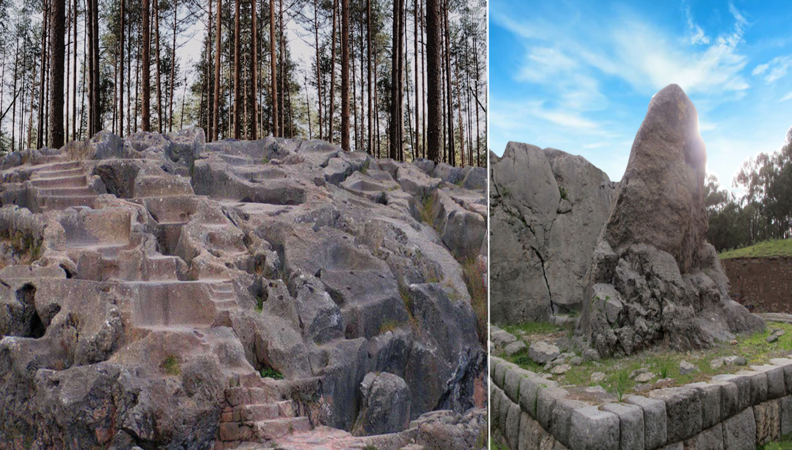
Part of the archaeological center of Ollantaytambo famous for its platforms in the shape of truncated pyramid, and hidden among the Andes of the Sacred Valley, lies the ancient site of Ñaupa Iglesia, located between Ollantaytambo and Urubamba, 18 miles southwest of Mahu Picchu. This mysterious and fascinating site, which has little known history and built long before the Inca, Ñaupa Iglesia (Choquequilla) is an ancient Peruvian ruin in the Sacred Valley of the high Andes. It sits up on the right side of the Huarocondo gorge, above rock, stepped terraces, similar to Ollantaytambo, and overlooks the valley of Pomatales. According to chroniclers, the Inca, at the time of the Conquest, claimed that it was built “in a time before our time, in a world that existed before ours, long before us.” These ancient people were called the Ñaupa by the indigenous peoples of the central Andes.
    Ñaupa Iglesia is known to have predated the Inca—how long is not known, but possibly thousands of years. Ñaupa Iglesia also has some very interesting geometry that shows a detailed understanding of astronomy and vibration. Even more fascinating is that the geometry links Ñaupa Iglesia with Egypt in certain angles and ratios can also be found in the great pyramids of Egypt.
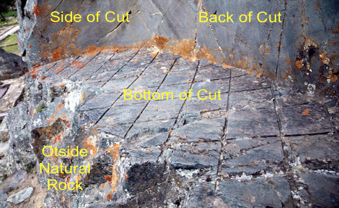
    The site was built up on a near-vertical ravine in the Andes, where they carved an inverted V-shaped entrance into the mountainside. There they placed bluestone rock, which was in stark contrast with the surrounding sandstone. Bluestone contains a type of crystal that was used in early radio receivers for its excellent piezoelectric qualities and it’s magnetic capabilities. According to legend, these mysteriously cut stones exhibit precise cuts seemingly made by some unknown form of ancient high technology. In addition, the site contains a false door of such that is claimed to be an ancient portal into another dimension or world. Legend also claims that false 'doors' such as this are considered to be spirit doors into the spirit world.
    The site has been long used as a sacred ceremonial site, even to this day, where it is said that contact with the spirit world can be made by those who bring offering and make ceremony in this ancient sacred and mystical place. At the entrance to the cave beside the ancient site is a large pedestal stone, called an altar by archaeologists, which was cut from a single stone and known to have celestial alignments.
Site of Ñaupa Iglesia

Originally called Ñaupa Waka because it fits Andean cosmology, when the Inca came to power they called this area Ñaupa Iglesia. Ñaupa Waka was deliberately destroyed; photographs show bore holes and from them it can be clearly seen that large pieces of rock have been removed. Another question is who did this and why?
    Drilling into hard rock needs special tools and these were not available to the Spanish in the 16th Century. There are parallels elsewhere that suggest these holes were probably drilled during construction.
Hole that has been bored into rock at the Ñaupa Iglesia site, where explosive has been used

There really doesn’t seem any alternative, considering the technology required and the depth of the holes. However, they were drilled, it is obvious that some form of explosive, probably black powder, was later placed inside them and the site was “blown up.”
    It might be of interest to know that the name Ñaupa Waka in Quechua means ‘Church’ (Quechua: ñaupa: old, ancient; Waka means place or house). Thus, the Ñaupas are inhabitants of the spirit world. Dominating the site is the cave ceiling forming an inverted ‘V’. It has been cut and smoothed with laser-like precision to create two different yet specific angles: 60 and 52 degrees. There is only one other major place on earth where these two numbers appear side by side, the angle slopes of the two major pyramids at Giza. In addition, there are terraces to grow maize (corn), potatoes, and other plants that were used for offerings to the Divinities.
Door cut into the rock

The bedrock is sliced with great precision to create a shallow door that goes nowhere. The same design appears in ancient Persia and Egypt. Then for good measure, they carved an additional altar with three alcoves into an outcrop of bluestone.
    Built long before the Inca, who merely inherited and maintained a culture that was, by their time of the 16th century, already long vanished. The ancient Aymara claimed such temples were long before the Inca. The style of stonework at Ñaupa Waka is consistent with that found in Cuzco, Ollantaytambo, and Puma Punku, and what these sites have in common is the myth of a traveling builder God named ‘Viracocha’ who, together with seven ‘Shining Ones’, appeared at Tiwanaku after a catastrophic world flood, since dated to 9703 BC, to help rebuild humanity.
    Ñaupa Waka is the same style as Ñaupa Rumi from the Hanan Pacha, the biblical time of paradise on earth. In Inca mythology, this time would have been the time of “land of the heaven above”.
The Stone Altar, perhaps an ancient observatory?

Edwin Salazar Garcés, author of Astronomia Inka, scientific director of Planetarium Cusco, and expert on the relationship between architecture and astronomy says that the axes of the Ñaupa Waka stone altar, projected at certain times of the year, pointed to positions of stars and constellations known anciently.
    In stark contrast with the surrounding sandstone, this single bluestone outcrop, or altar, has been expertly carved in three niches, or open chambers. Each has different dimensions and depths, and with their axes pointing to three different directions facing the horizon. Such stellar alignments were very accurate anciently, while today they have moved a little and do not agree with our calendrical dates due to the precession movement of the equinoxes. They are still, however, verifiable by very close approximation.
The approach up the mountain to Ñaupa Iglesia
 
While this site was built long before the Inka, the information we have begins at that time. Thus, the axis of the carving (A in the photo) has an azimuth of 149 ° and pointed at the exit of the Cruz del Sur (above the hill) on April 26 at 18:15 hours. This was the evening of the day of the Sun Nadir and announced the beginning of the big harvest that happens in the month of May.
    The central chamber (B), has an azimuth of 137 and pointed to the group of stars that form the tail of the western constellation of the Scorpion, and pointed exactly at the star Sargas (Theta star of the Scorpion). This happened on June 21 at 18:30 hours. The day of the beginning of “Inti Raymi”—at the time of the summer solstice—celebration of the god Inti. This same axis receives, at noon on October 30, the light of the Sun that falls in a zenith, just at the moment of the passage of the Sun by the meridian at this place, at 11:30 am.
    A spike that protrudes above the rock roof (which appears to have been the carved head of a bird) points precisely above this central chamber and would have coincided with some ritual ceremony. During Inca times this date belonged to the month of the "Aya Marq'ay", (month of the procession of the dead) and closed with the modern day of the deceased, November 2nd.
    The last indentation (C) had an azimuth of 102 -103 degrees at the exit of the star Sirio (Alpha of the Major Can. This occurred around August 18, at 04:00 hours, the day and marked the time of planting. The same alignment was visible on December 23 at 19:15 hours, the day of the winter solstice. Thus, its energy is certainly stellar and not earthly.
    In addition, there is a rock-cut doorway, marking a gateway into another world. One would actually need magical powers to cross through solid rock, and marked the symbol of a spirit door into paradise.
A most sacred place high up on a mountain top where ancient Peruvians met for spiritual purposes

In addition, this site has the three-step design defining the universe that defines the three kingdoms known to the ancient Peruvians.  view of the Universe and how the three levels of existence are connected to each other. The oldest iteration of the design is carved on a monolith at Tiwanaku, the world's oldest temple complex.
    It might be of interest to consider the words of Nephi “I was caught away in the Spirit of the Lord, yea, into an exceedingly high mountain, which I never had before seen” (1 Nephi 11:10, emphasis added); and “that after I, Nephi, had been in the land of Bountiful for the space of many days, the voice of the Lord came unto me, saying: “Arise, and get thee into the mountain” (1Nephi 17:7, emphasis added), and also “And I, Nephi, did go into the mount oft, and I did pray oft unto the Lord; wherefore the Lord showed unto me great things” (1 Nephi 18:3, emphasis added), and “Come ye, and let us go up to the mountain of the Lord, to the house of the God of Jacob; and he will teach us of his ways” (2 Nephi 12:3).
    In addition, those who have been to the House of the Lord might find similarity in the three kingdoms as well as the spiritual symbolic “door.” It might also be recognized that the Heartland and Great Lakes models do not have mountains or “mounts” where such temples and spiritual matters could have been conducted. In fact, the temple in the city of Nephi anciently was identified with being on a hill overlooking the city of Shilom, where temple and high tower were built (Mosiah 11:8-9).

Thursday, April 23, 2020

Chinkanas, the Mysterious Secret Passages

When king Limhi and Ammon discussed escaping from the lamanite-controlled city of Nephi (Mosiah 22:1), in the midst of their discussion, Gideon suggested that he had a route that would get them out of the city and into the wilderness without being seen. Gideon told the king, “Behold, the back pass, through the back wall, on the back side of the city… and we will pass through the secret pass on the left of their camp when they are drunken and asleep… and we will travel around the land of Shilom” (Mosiah 22:6,8, emphasis added).
The Nephites followed king Limhi and Ammoron through a secret pass and into the wilderness

As a result, the king sent out a proclamation to the people and gathered with their gold, silver and their precious things, which they could carry, and also their provisions with them into the wilderness and they pursued their journey” (Mosiah 22:12).
    Now the word “secret” as found in the 1828 Webster American Dictionary of the English Language, tells us that the word came from the the Latin secretus, that is: “seg” is to separate, as in Latin seco—to cut off. Properly, “to separate,” hence, hid; concealed from the notice o knowledge of all persons except the individual concerned; unseen, private, secluded; removed from sight, unknown; not seen, not apparent; kept from observation; a thing not discovered and therefore not known.
    Consequently, in the Land of Promise, there has to be a major city—the city of Nephi—where there is a back pass that is secret, i.e., one not known to others, or one difficult to find and know about. Gideon, as the king’s chief captain over the military, had acquainted himself with all the land about the city as would be expected by the military commander of the fortress, and was aware of this secret pass that by definition would have been unknown to others.
    In Andean Peru, there is a set of intricate passages and a network of underground galleries located in Cusco, very close to Sacsayhuaman that connected the fortress with the valley below. Some of these passages pass through what is known today as the Rodadero and one in particular goes around the esplanade and the complex behind the fortress and into the wilderness, or undeveloped country beyond.
A secret passage through the rock hill known as Rodadero behind Sacsayhuaman

The Chinkanas (Quechua “place where one is lost), also known as a “labyrinth,” are mysterious caves made on limestone rock situated behind Sacsayhuaman. Who made these passages and tunnels, or for what purpose, is not known, but they were pre-Inca.
    Around these mysterious constructions, that were made by the hand of man in some remote past, along with parts that were natural, many myths and legends have developed over the millennia. One of those tales is that one of the tunnels from Sacsayhuaman was subterranean and provided a path to the valley below the temple there.
Entrance to one of the subterranean tunnels behind Sacsayhuaman

Different chroniclers of the Conquest have left writings on the chinkanas, including that of one tunnel that had so many branches that it was easy to get lost—even to the fact that some had entered never to be heard from again. There is also one that indicates a person in terrible condition arose out of a passage into the temple in the valley below that had entered the tunnel at Sacsayhuaman more than a year earlier.
    In fact, the Jesuit Priest Agnelio Oliva wrote a few years after the Conquest that a vast subterranean network existed in the Andes, which inferred engineering skills of the highest caliber which the early inhabitants of South America obviously possessed. He tells us that the megalithic stonework of Tiahuanaco was ancient even at the time of the Conquest, nor could the Indians of the period provide an answer as to the identity of the megalithic builders.  
    The Roman Catholic Society father recorded the words of an old Inca quipu reader to the effect that the real Tiahuanaco was a subterranean city exceeding the one above ground in vastness. It was believed that the entrance to the underground apartments could be gained through four tunnels. Last century one passage was evidently found as treasure hunters managed to get in, to look for gold, but only one came out. He brought out with him two gold bars but left behind his sanity. After this incident the Peruvian government decided to wall up the cave entrance..."
    He also wrote that there were splendid and large buildings in the labyrinth below and to it was attributed the construction of the underground labyrinth which were exits to the border roads, bridges, fortresses and other buildings. “
One of the tunnel entrances

According to Martín de Murúa, a Basque Mercedarian friar, in addition to his missionary work, gathered data to write a history of the Andean past translating from the Quechua language. He was assisted in his translation by a native Inca nobleman Felipe Guamán Poma de Ayala (also known as Guamán Poma), who provided over 100 illustrations of great historical significance for the work.
    In a chronicle of 1590, written by Father Mercedario Fray Martín de Murúa, in Chapter IX he states: “[they] made a path under the earth in the fortress of this city of Cuzco to Curicancha which was where they had the temple and oratory of the sun and the moon and of all the other huacas they worshiped, until the entrance of this socabón [tunnel] in the said fortress where they called the chingana although everything is already lost and finished, because there is no one who can see where it is going, but it is only the entrance, because in entering some stretch they are lost and they cannot find the way. Because there is no memory of it in the said place of the Curicancha and they…had it closed because no one entered inside” (Martín de Murúa, Historia general del Piru, Chapter IX, 1590,
Inside the tunnel claimed to lead down to the valley
Another chronicler of the conquest was Garcilaso de la Vega, who stated: “A network of underground passages, as long as the towers themselves were all connected. The system was composed of streets and malls starting in all directions, all with identical doors. It was so complicated that even the bravest did not venture into the labyrinth without an orientation guide that consisted of a roll of rope or thick brabant attached to the entrance door to be unwound as it advanced through the tunnels. As a child I used to go to the fort with the boys my age, but we did not dare to go far, always staying in places where there was sunlight, because we were very afraid of getting lost, after hearing all the stories that Indians told us about the place.”
Tunnels Sacsayhuaman and claimed to reach the Koricancha Temple in Cuzco

He also stated: “Some of the tunnels reached Cusco, three kilometers away, communicating Saqsaywamán with the Koricancha and other buildings. Other tunnels went into the very heart of the Andes, not knowing exactly where they were leading” (Garcilaso de la Vega, Royal Commentaries, Office of Pedro Crasbeeck, Lisbon, 1609).
    Investigations into these labyrinths became important again in 2003, when the international press echoed after the discovery of a large underground tunnel just over one mile-long in the Cusco subsoil at the time of the Koricancha Project (L. Norman Shurtliff, The City of Nephi, Author House, Bloomington Ind., 2018).
    For centuries rumors persisted that a series of tunnels existed under Cuzco, even in Inca times, who it is claimed by many historical figures (Incans and Spaniards) from the era of the Spanish Conquistadors who stated that the Incas kept a well-guarded secret of underground tunnels crisscrossing Bolivia and Peru. They also attested that those ancient tunnels hundreds of miles long were built by an unknown peoples many years before them!
    This, of course, was always considered merely myth until a series of tunnels were discovered and confirmed by Pi Rambla. What we know about these tunnels, where they lead, and their original purpose is not now. However, it bespeaks of a secret pass as we find in Mosiah: “back pass, through the back wall, on the back side of the city… we will pass through the secret pass on the left of their camp when they are drunken and asleep” (Mosiah 22:6-7).
 

Wednesday, April 22, 2020

Nephite Stonework at Ollantaytambo

As the ancient Peruvians expanded outward from Cuzco, they obviously would have built other settlements and cities. One of those locations outward from Cuzco is Ollantaytambo (Ullantaytampu, pronounced oh-yen-tie-TAM-boe). It is a marvel of engineering and architecture, and is both a fortress, and a complex city. Here is found massive cut and dressed stones from the Kachiqhata quarries located in a ravine across the Urubamba River some 3 miles from the town.
Mountain top city and fortress of Ollantaytambo

Perched on the top of a steep slope that overlooks the town located 58 miles northwest of Cuzco and 30 miles from Machu Picchu, sits the massive and powerful defensive fortress. At the northwestern end of what is called the Sacred Valley, in a section known as the Temple Hill, which includes the massive and extensive terraces up the side of the mountain, sits the ancient site of Ollantaytambo.
    The site is a rare if not unique construction in Andean Peru, where its massive citadel served as both a temple and a fortress. At some unknown point in time, and for unknown reasons, work mysteriously stopped on this huge project.
City at the top of the Ollantaytambo fortress

The upper section of this site is located the fortress, made up of a series of carved stone terraces built to protect the valley from possible invasion by warring tribes. One of the best-preserved areas lies north of the Hanan Huacaypata square: an area of 15 blocks of houses built on top of carved stone walls.
    One of the most interesting places in Ollantaytambo is the Gateway of the Gods, which was built several thousand years before the Inca arrived at Ollantaytambo. According to researchers it was built by a culture called the Urin Pacha, a name given to these ancient people because researchers have no idea who they were, where they came from or where they went. Others, like anthropologist Jesus Gamarra, believe the site was built by the Arak civilization. In any event, it is clearly evident that the earliest parts of Ollantaytambo date into BC times.
Two of the Quarry sites from which the large slabs were cut and hauled down the mountain, across the valley and river and up the other side to Ollantaytambo

This site features three main quarrying areas: Mullup'urku, Kantirayoq, and Sirkusirkuyoq, all of which provided seven blocks of enormous rose-colored rhyolite monoliths, an igneous volcanic rock of felsic composition that were stood upright in a row far taller than a person and of undetermined purpose.
    An elaborate network of roads, ramps, and slides connected them with the main building areas. Because of the nature of fracture planes, most blocks in this quarry have two relatively clean faces needing little or no work. Thus, with an adequate work force two, at the most three weeks, is all it would have taken to prepare even the largest block in the         quarries. Within these time frames, 15 crews of 20 men each, could have roughed out the total of 150 blocks found in the quarries, on the road, scattered around the construction site, and on site and in position in less than eight months.
An ancient wall of six mammoth stone blocks

The Wall of the Six Monoliths is one of the most dominating features of Ollantaytambo’s landscape. It has been constructed with six huge granite blocks that interlink perfectly with one another. According to legend, the monumental blocks were transported across a vast plain, by water and then up a mountain – all of this without the use of crane lifting technology. Archaeologists have also suggested that the granite blocks appear to have been cut using stone or bronze tools, but no such tools have ever been recovered near the site.
    These enormous slabs of andesite stone which form what is referred to as The Wall of Living Rock. The curved slabs appear to have been removed from a mountain side with pin-point accuracy. The fact that andesite rock has been used at all is baffling in itself. Today, engineers can only extract it using diamond or laser cutting technology. But that ancient people could gain access to it with such perfect control in their cutting raises major questions about these people and the type of technology to which they had access.
Large hewn and dressed stone laying unfinished on its emplacement ramp

As mentioned, the stone blocks were brought down the mountainside on wet sand, across the Valley and the Urubamba River, then up a long construction ramp of logs to the great fortress-temple complex above the village of Ollantaytambo. This fortress was famous for its beautifully fitted great slabs of red porphyry stone forming a portion of what some archaeologists claim must have been intended to be its principal temple. But this complex, an ancient work in progress was never finished. A number of large cut blocks were abandoned en route to the site and remain today, known as piedraw cansadas or "tired stones".
    Within the complex, a stone that was in the process of being maneuvered into its final position can be seen lying on its emplacement ramp. Other stones exhibit peculiar grooves which were meant to be filled with molten bronze or copper to lock two adjacent stones together, as was also done among the cultures of Tiwanaku around Lake Titicaca, as well as the Greeks in the Old World for their temple construction.
Where one of the many blocks of stone was cut from the rock of the mountain side

In the quarries where these blocks were cut nd shaped, the blocks were removed in such a precision that we hardly find scratches on the rock. The rock from where the slabs were removed is andesite and that material is really strong and hard to “cut,” you would need something that is stronger than andesite to accomplish this.
    In interesting fact is that these slabs were so precisely removed that there are no broken edges or any other signs of extreme force applied that could have caused the material to “break” or deform. The corners from where they were removed are not sharp but are almost perfectly round and today experts have no way to explain this in a society claimed to have had only bronze tools.
    Many of these stones have almost perfect angles and in some cases are as smooth as glass. While archaeologists are in awe how this was done with only stone and bronze tools, the Nephites had steel tools.
    As Nephi wrote: “And I said: Lord, whither shall I go that I may find ore to molten, that I may make tools to construct the ship after the manner which thou hast shown unto me? And the Lord told me whither I should go to find ore, that I might make tools” (1 Nephi 17:9-10). Nephi also tells us he “taught his people how to work in iron and steel” (2 Nephi 5:15), and Jarom claims early on the Nephites had “machinery and steel, making all manner of tools of every kind to till the ground” (Jarom 1:8)
Incredible defensive walls on top of the mountain where Ollantaytambo sits

In addition, from the very beginning the Nephites were concerned about the anger and danger of those left behind in the Land of Lehi, the land of first inheritance. As Nephi wrote of his brothers and those with them: “But behold, their anger did increase against me, insomuch that they did seek to take away my life” (2 Nephi 5:2,4).
Nephi, himself, feared coming attacks from his brothers and those with them. He was so confident they would soon approach them in their new home, that he “did take the sword of Laban, and after the manner of it did make many swords, lest by any means the people who were now called Lamanites should come upon us and destroy us; for I knew their hatred towards me and my children and those who were called my people” (2 Nephi 5:14).
    This would have included the building of defensive walls around their homes and new city. After all, Nephi states that he “And I did teach my people to build buildings, and to work in all manner of wood, and of iron” (2 Nephi 5:15).
Walls fitted without mortar much like those at Sacsayhuaman

In other areas of the fortress, we see some incredible stonework: staggered, mortarless, irregular stones, fitted together like jigsaw puzzle pieces. This stonework construction has remained standing after numerous devastating earthquakes that have crumbled the adobe and brick structures all around it.
    In addition to quarries, stones were found on landslide talus, obviating the need to detach the stone from the living bedrock.
Narrow stairways led up from the valley floor to the height of the city

To reach and penetrate of Ollantaytambo, an enemy had to charge up long flights of narrow stairs alongside huge terraces with eight-foot high walls, making it impossible for any approach except through narrow and easily defended approaches.
In addition to the defensive walls and monolithic construction of Ollantaytambo, it should be noted that the manner of cutting and fitting the stones at Ollantaytambo matches that work accomplished at Sacsayhuaman.
Top: Interlocking blocks at Ollantaytambo; Bottom: Interlocking blocks at Sacsayhuaman
Built without the use of mortar and perfectly fit, not a piece of paper could fit between the joints of these stones that often weigh over 50 tons. These interlocking blocks are almost identical in their use at both sites.
    It is important to consider these defensive walls and cities of ancient Andean Peru, since they match the scriptural record and no such bui8ldings and walls have been found in ancient North America. Nor have such defensive arrangements in Mesoamerica, though they have numerous cities made of stone but no defensive walls for the most part around them.

Tuesday, April 21, 2020

Stonework at Sacsayshuaman—The City Nephi Built – Part VII

Continued from the previous post regarding the fortress and more specifically grounds and structures around Sacsayhuaman.
Top: Larger area around Cuzco; Bottom: Sacsayhuaman hill and adjoining Pukamuqu hill

Pukamuqu ("red hill"). This a mountain in Peru. It is situated in the Cusco Region adjoining the hill upon which Sacsayhuaman stands. It is a natural viewpoint with panoramic views of the city and has a 26-foot high statue called Cristo Blanco (“white Christ”).
    This is likely the hill that Ammon and his friends camped on following their discovery of the city of Nephi after “wandering many days in the wilderness, even forty days did they wander” (Mosiah 7:4). And “after wandering many days, they came to a hill…and pitched their tents” (Mosiah 7:5). The next day “Ammon, Amaleki, Helem and Hem went down into the land of Nephi” (7:6).
Pukamuqu Hill adjacent to Sacsayhuaman

At an elevation of 11,800-feet, the hill has a magnificent sweeping 180º view of the entire area. This would be where Ammon looked down on the city of Shilom and also the city of Nephi. The land of Shilom borders the lands of Nephi, Shilom and Helam, with Shemlon and Nephi directly below the hill upon which Ammon camped.
    Below the hill is Shilom, an ancient city built by the Nephites before the exodus under Mosiah I. When that migration took place, the Lamanites occupied the city, but let it fall into decay. When the Nephites, under Zeniff left Zarahemla and regained possession of the land, they repaired its dilapidated walls and buildings, and king Noah greatly enlarged and beautified it.
    Later, Zeniff’s son, Noah, built a very tall tower had been built by king Noah near the temple, overlooking the lands of Shilom and Shemlon (Mosiah 11: 12; 19:5-6; 20:8).
The Moray Circles

Moray. Situated on a high plateau northwest of Cuzco and west of Maras village in Peru, the stunning Moray ruins are additional proofs of the great ingenuity of the ancient Peruvians. Located 33 miles northwest of Cusco, Moray exhibits an admirable ancient experimental farm, where a natural depression has been transformed into enormous terraces superimposed in concentric form in the shape of a coliseum.
    Moray is set apart from other ruins in their function. It is still not completely certain what their use was, but archaeologists have a pretty good idea of this site, whose six terraces in connected ellipses rather than perfect circles, surround the concentric heart of Moray, a set of eight downward terraces.
   Pollen studies of these various levels show that soils from different regions of Andean Peru were imported to each of the large terraces, which has led some to believe that the ancient Peruvians were experimenting with vegetable crops to determine which would be disseminated for domestic production by the farmers
    This suggests that the ruins were used as laboratories to experiment on different crops at varying temperatures. Others say they serve as agricultural structures to grow a different breed of corn in the cold climate of the region. This would not be surprising, since about 60% percent of the world’s food crops originated in the Andes, including hundreds of varieties of maize and thousands of potato varieties.
    Whatever the purpose was, there is no denying the fact that this archaeological site is a piece of ancient engineering wonder that one should see in their lifetime.
    Achieving up to 500-feet in height levels, this technology allowed the ancient farmers to study the effects of altitude on different plants and create diverse microclimates to experience and to obtain a variety of plants.
It is in fact an ancient agricultural laboratory. Each terrace possesses contention walls which are connected by a complex system of artificial channels of irrigation that again are a sample of incredible technology.

    The purpose of these depressions is uncertain, but their depth and orientation with respect to wind and sun creates a temperature difference of as much as 27 °F between the top and bottom. This large temperature difference was possibly used to study the effects of different climatic conditions on crops. In other words, Moray was perhaps an agricultural experiment station. As with many other sites, it also has a sophisticated irrigation system.
    The top level is often chill, but walking down to the bottom—a 98-foot deep depression—hopping from one terrace to another, to get to the bottom, which is decidedly warmer or cooler at the bottom, depending on the time of day.
    The site is located near the village of Maras and the Maras Salt mines.
The Maras salt pools

Maras. Located at 37 miles from Cuzco and 4½ miles from Moray, also called Salinas de Maras, this bizarre site was probably an agricultural center used for cultivating new crops.    The temperature varies between terraces at different levels, which would have facilitated the selection of crop strains for farming in different areas with various ecosystems.
    These layers of beige and white salt pants were used ancient to crystallize salt from the water, as they still are today are still used to crystallize salt from water. The view of this complex of nearly 3000 wells is spectacular and the ancient people channeled the salt water that bubbles to the surface from a spring called Qoripujio towards man-made wells.
    From the exposure to the sun, the water evaporates and the salt remains on the surface where the element is extracted in its natural form and transported to market to be sold. Today it is known worldwide for its great taste and nutritional value.
    The settlement of Maras was an important town anciently and the main supplier of salt of the southern highlands—the salt named Kachi Raqay—was in the form of terraces or platforms , which was crossed by a stream that feeds the pools of salt water.
    The salt was composed of about five thousand pools of about 17 square feet each, with the water seeping into the ponds and evaporating per share of sunshine, making sprout coarse salt crystals. After 1 month, the salt reaches 4-inches high and has to be harvested.
    Using Maras Salt dates back thousands of years and is inherited in each family, but is managed communally.
    The light of all the wells is spectacular. The villagers show visitors their ancestral techniques allowing them to participate in the collection, as well as festivals and Andean rituals.
    The place is highly recommended for lovers of photography. The area is ideal for trekking and mountain biking, and the views are spectacular.
Nephi building a ship which the Lord showed him how to do so beyond that done or known in his day

While we do not know all that Nephi taught the people, we know he did teach his “people how to build buildings, and to work in all manner of wood, and of iron, and of copper, and of brass, and of steel, and of gold, and of silver, and of precious ores, which were in great abundance” (2 Nephi 5:15). He also knew how to build a ship beyond the ability of the men of his age and far different than anything done before that time (1 Nephi 18:1-2). He also was taught many things by the Lord (1 Nephi 18:3). It might be assumed from this that Nephi was taught how to build in a land of earthquakes buildings and structures that could withstand the shaking of the earth and last for a very long time.
    Certainly the land of ancient Peru shows evidence of building unknown in ancient times, and still admired by modern engineers today—some of which is still unexplained today.

Monday, April 20, 2020

Stonework at Sacsayshuaman—The City Nephi Built – Part VII

Continued from the previous post regarding the fortress and more specifically grounds and structures around Sacsayhuaman which was an architectural masterpiece, with impressive megalithic ruins located in the peak of a hill that dominates the north of the city. The historians of the Spanish conquest attributed it initially for military purposes that then became religious, and finally a place of work.
    The walls are formed by enormous stone blocks that were assembled in a perfect way without use of cement. The main wall is constituted by three successive walls in zigzag, the second and the third superimposed to the first one. The platforms have an average of  1200-feet in length and communicate by stairs, and access doors. The throne, benches or seats surrounded by rocks in front of the ramparts north of Sacsayhuaman that dominate the esplanade and the hill located in the same plateau. Sacsayhuamán was scenario of important historical facts, especially during the Spanish conquest.
The steps and stairs at Sacsayhuaman

Rodadero Stairs. Along with carved outcrops and boulders at Rodadero Hill are carved steps to the top of the hill, as well as carved steps throughout the complex. Though there is much discussin about their not being stairs in the temple of Solomon, we actually find in Hebrew history and the building of Solomon’s Temple that there were winding stairs in the middle chamber that workers ascended to receive their wages (I Kings 6:8). The word “Lullimוּבְלוּלִּ֗ים is used for “stairs,” as found in the Old Testament.
    The staircase mentioned in Solomon’s Temple was obviously unlike those of most Eastern buildings, within the side structure. These side chambers were used while the Temple was being built for the purpose of paying the workmen their wages. Later, they were used as store-houses or treasury rooms of the Temple into which the treasures and gifts to the Temple were placed. Historians feel it necessary to state how the second and third stories were reached, and the staircase which led to them causes him to speak of the position of the door which opened upon it.
Steps in Solomon’s Temple

There were also steps on the east side of the altar (Ezekiel 43:17). In addition, there were other stairs in the temple, both to the large altar as well as to the Holy Place, the Beautiful Gate, and the Upper Court. Obviously, Lehi and his sons, when attending the temple were familiar with the stairs, and used the technology (over previous use of ramps) when building the city of Nephi.
    In addition to the area around Cuzco there were numerous places established anciently by those early Peruvians.
1.Kencco (or Qenko). A sanctuary dedicated to the adoration of animals, ruins formed by a rocky place with stairs in zigzag, it has a main building like a circular amphitheater where 19 window sills are located as a way of seats. It is presumed that this place was an adoration place, supporting this presumption the presence of an enormous stone block of 20-feet height that has the appearance of a puma. There is a labyrinth entrance toward underground galleries, passages, channels, and stairs with signs of a remote culture; these reveal a series of drawings and engravings outstanding the figures of pumas. It is located at 2½ miles from the Main Square of Cuzco city along the way to Sacsayhuamán.
Puca Pucará was built from irregular shaped stones which fit together poorly, suggesting the site was constructed in a hurry because of an imminent threat

2. Puca Pucará. Another archaeological location, located in the peak of a hill overlooking the road to Pisac, it was a military position and an administrative center. Its name means “red fortress” and is taken from the red granite that was used in its construction. For its proximity to Tambomachay, it is believed that it had relationship with its defense as an outpost, as well as the control of the route to Calca that led to the Forest County.
    It is a fortification formed by platforms, stairs, passages, turrets, windowsills and a wall that defends the whole construction in a circular shape. In Puca Pucará there are places, inner plazas, baths, aqueducts, and an old road. The buildings are made of stones that come in many sizes medium-small, on the surface of the rocks is very irregular, compared with other archaeological remains. It is located at 4½ miles from the Main Square of Cuzco city.
Tambomachay consists of a series of aqueducts, canals, and waterfalls that run through the terraced rocks

3. Tambomachay. Construction of fine lithic finishes and high domain of the hydraulic engineering. It is a group of walls, united by stairs, with springs that fall to a puddle through channels. The fall of water that gets the attention in these ruins part from the terrace of the second wall and the drainage spill on the first where a small puddle is found. The window sills, hole or niches of 6½ feet high, was the place from where water poured from drains into a pool, which is considered a set of baths ancient. according to the historians, an important people of his court subdue cult to the god Inti (sun) with rites of water. It is located at 5 miles from the Main Square of Cuzco city.
Laqo, Lanlakuyoq and Cusilluchayoq

4. Laqo, Lanlakuyoq and Cusilluchayoq. A pre-Hispanic adoration places, located 3 miles east of Cuzco. There are representations of felines, monkeys and snakes carved in the rocks. It is a particularly interesting place for the followers of occult and spiritual movements.
    Its fertile lands make then excellent producers of potatoes, ollucos, ocas, lima beans, barley and wheat, traditional products which crops existed during Inca time and they continue being the commerce axis of that zone.
    These pre-Columbian observatories were ceremonial centers of worship with a singularly beautiful landscape and abundant flora and fauna. This includes llama, kestrels and falcons.
Chinchero

5.Chinchero. Located some 28 km (17.4 miles) to the northwest of Cusco, the so-called "El Pueblo Del Arco Iris" (the town of the rainbow), or Chinchero is an ancient town of Hispanic architecture but built on old Inca construction.
    Its people are the most conservative of the Inca traditions, wearing traditional clothing and are famous for carrying out the "catu", or exchange fair of agricultural products, in which the use of the currency is discarded and everything is made in exchange. Also outstanding are their textile crafts. The town also has a beautiful colonial church with famous paintings of the Escuela Cusqueña (Cuzco school) depicting beautiful Andean landscapes surround the town, along with the snowy mountains of Chicon and Veronica in the Urubamba mountain range.
Oenqo

Qenqo (Kencco). From the Quechua language meaning labyrinth or zig zag, located about 3½ miles north of Cuzco. It sits on the adjoining hill to the east from Sacsayhuaman and supports numerous ruins. Specifically, Qenqo (O’enko) presents a circular amphitheater and rocky stairs in zigzag form. In the interior it has a meticulous and finely elaborated altar where agrarian rituals were performed, in the upper part of this rocky place there is a series of seats, steps and carved stairways. It is one of the largest huacas (holy places) in the Cusco Region. Many huacas were based on naturally occurring rock formations. It was believed to be a place where rituals and mummification took place.
    Obviously, as the ancient Peruvians expanded outward from Cuzco, where they spent the first 400 years of their presence in the Land of Promise, they obviously would have built other settlements, villages and cities. Beginning in the city of Nephi (Cuzco) we can track them outward in the various ruins that dot the area.
(See the next post, “Stonework at Sacsayshuaman—The City Nephi Built – Part VII,” for more regarding Sacsayhuaman and the surrounding constructions)