skip to main |
skip to sidebar
Continuing with Arthur
Budvarson’s six questions asked of the Smithsonian Institution about the Book of
Mormon and their answers and our evaluation.
His first question: “Have there ever been any cities named in the
Book of Mormon been yet discovered?”
When these cities were first excavated and uncovered, there were no
signs as to what they had once been called by the builders and early
inhabitants. Archaeologists named them according to their location, surrounding
areas, or local names of the site given them after the Spanish arrived
We suppose that critics expect,
if the Book of Mormon is correct, to find excavations of cities bearing the
name of Zarahemla, Nephi, Antiparah, or Bountiful, etc. The question that needs
to be asked instead is, if archaeologist excavated a city that originally had
been called Zarahemla during Nephite times, how would they know of such a name?
Perhaps one might expect to find find a plaque inscribed in Hebrew or
reformed Egyptian saying, “This is the city of Zarahemla, founded 555 B.C.” or
a road sign on the approaches to a city listing the equivalent of “5 miles to
Zarahemla.”
Critics, even
experts, are perfectly correct in saying that “no archaeological site has been identified with any of the names of the
cities mentioned in the Book of Mormon” as did Dr. Frank H. H. Roberts,
Jr., Acting Director of the Smithsonian in his reply to Arthur Budvarson on
October 10,1958 (in answer to the latter’s question: “Have any of the cities
named in the Book of Mormon been discovered?”)
So let us look at
this question from a different angle. We know that there are scores of ancient
cities in southern Mexico, Guatemala, Belize, etc., as well as scores of
ancient cities discovered in Ecuador, Peru, Bolivia, etc. We can see the
cities, archaeologists have studied them for decades, and many books are
written about them. Now the question to be asked is, “Do we know the ancient
names given those cities by the people who built and lived in them?”
The answer is a
definitive “no.”
No one knows the names of hundreds of Nephite-period
(600 B.C. to 400 A.D.) cities so far discovered in Central and South America
that were given them by their builders. The names we know them by in
Mesoamerica: Chichen Itza, Tik’al, Caracol, Uxmal, etc., or in South America: Chan
Chan, Caral, Chavín de huántar, Machu Picchu, Pachacamac, etc. None of
these names by which we now know them were the names known by the original
builders and inhabitants of those cities in antiquity.
What we know of all these cities and the hundreds of
other ancient sites now discovered, are names given them long after the Book of Mormon period. The names we have are those
assigned to these sites by their discoverers, or claimed to have been called
long after the Nephite period by historians or natives dating to after the
Spanish Conquest. We know what the Aztecs (1427 A.D. ) called their cities, as
an example, and what the Incas (1400 A.D.) called theirs, but these
civilizations existed a thousand years after the demise of the Nephite nation.
For another example, take the pre-Inca site of
Tiwanacu (Tiahuanaco) along the Peru-Bolivia border, just south of Lake
Titicaca. The name we know this city by today was given it by Pedro Cieza de
Leon, who came upon its remains in 1549 while searching for the Inca capital of
Qullasuyu. It is believed this site may have been inhabited as early as 1500
B.C., but surely by the 6th century B.C.
When Cieza de Leon asked numerous Inca about the
ruins, they told him it had always been there and no one knew who the builders
have been. When it was actually built, no one really knows. During the time
period between 300 BC and AD 300, Tiwanaku is thought to have been a moral and
cosmological center to a population of 25,000 to 30,000 inhabitants before it
expanded its powerful empire, which is believed to have eventually supported a
population of between 285,000 and 1,482,000
The
city of Tiahuanaco, with temples, subterranean courts, and exterior walls,
covered an overall empire that stretched from Bolivia to Peru and Chile. It was
one of the most important civilizations prior to the Inca Empire in all of South
America
According to Arthur “Arturo” Posnansky, a
well-respected avocational archaeologist and author of Tihuanacu, the Cradle
of American Man, it may have even existed in the antediluvian period. The
name Kalasasaya, associated with this
site, is also a modern name given it, as was the name Lukumata and Akapana,
along with another site nearby today called Puma Punku—all of these names we
use today would have been unknown to the original builders.
Its site and
workmanship is extensive, with the largest stone block weighing 131 metric
tons, another 85 tons, and within the Akapana (temple) an andesite block
estimated to weigh 66 metric tons. Without question, Tihuanaco is an example of a major
site and empire dating to Nephite times, yet its original name and the original
builders and occupants are unknown to modern history. So the site is named Tiahuanaco (Tiwanaku,Tiahuanacu), a name whose
origin is unknown, possibly passed down through the Inca and the Spanish. It
may have come from the Puquina, an extinct language once spoken by a native
ethnic group in the region surrounding Lake Titicaca and sometimes associated
with Tiwanaku, and believed by some to be the “runa simi” cryptic language of
the Inca nobility. The point is, no one knows what this city, region or people were originally called.
An example in Mesoamerica are the ruins of Copán,
which some claim was occupied during the Nephite period, and existed over
a two thousand year stage. Located in western Honduras, near the Guatemala
border, it lies in a fertile valley among foothills at about 2300 feet
elevation. The civilization here is said to have had a major influence on
regional centers across western and central Honduras, had a population of some
18,000 to 25,000 at its height, and covered an area of over 100 square miles.
It was considered one of the more powerful Mayan city states; however, it was
long abandoned before the Spanish arrived.
The
Mesoamerican site of Copán in Honduras near Guatemala, was discovered in 1570
by Diego Garcia de Palacio, and is one of the most important sites of the Mayan
civilization
The ruins first appeared in the book Incidents of Travel in Central America,
Chiapas and Yucatan by John Lloyd Stephens, written in 1841 regarding an 1838
expedition (this is the book that found its way into the hands of Joseph Smith
in 1843). Called Copán since its discovery in 1576, no one knows the original
name by which the settlement was known in antiquity, though some have suggested
it is associated with words like “Corner,” Summit” or “Motmot.” Others claim it
might have earlier been known as Oxwitik,
though that meaning remains obscure; however, the area was called Quirigua for
a time, though that is really the name of a site about 30 miles away. The
original name of Copán is simply unknown.

The point is, we are not going to uncover ancient
signposts or city signs telling us the original names of these cities.
Consequently, archaeologists and anthropologists have no idea what these many sites in Central and South
America were first called by the builders and early occupants. Yet no one doubts
these places exist. What were they called, who built them, and what is their
connection to modern knowledge is still unknown after more than a century of
investigation.
But they do exist,
they are there, and they do date to the period of the Nephite nation or shortly
afterward in the case of Central America. The important thing to keep in mind
is that basically all our information to date on the region of the Book of
Mormon civilizations—Ecuador, Peru, Bolivia and Chile in the south and Mexico
and Central America in the north, pertains to the archaeological developments of
modern man during the periods long after that of the Book of Mormon. The
civilizations that existed or co-existed in the same time period, such as the
famous Norte Chico, Wari, Moche, Canaris,
Caral Supe, Chavin, Tiwanaku, etc., in South America, and in Mesoamerica, the Maya, Teotihuacan, and
Zapotec cultures along with the empires of the Toltecs and Aztecs, are simply not known to the modern era. In fact the specialists in
the field of American archaeological areas will be the first to admit that not
enough is yet known about the "Preclassic" period of these regions—i.e.
the period of the Book of Mormon—to enable anyone, least of all a true
scientist or scholar, to reach a valid conclusion as to the claims of the Book
of Mormon.)
It is not, therefore,
the oft-quoted opinions of "scientists" that will decide the
authenticity of the Book of Mormon, but the actual evidence on hand and yet to
come forth, both internal (validation of the record within the Book of Mormon
itself), and external (archaeological and anthropological data, relating to the
actual area and period of the Book of Mormon people). The fact that science has found cities and cultures in South and Central America that match the time frame and writing of the Book of Mormon should suggest to anyone of the connection. However, science is extremely reluctant, if not loathe to use anything connected to a religious record as a basis for "scientific" discovery.
Therefore, any
criticism of this nature—not finding any named city of the Book of Mormon
period, is a moot subject. No names of any sites of prehistory in the Americas
is known today by the name they were known by their builders and first occupants.
(See
the next post, “Letter of Arthur Budvarson – Pt III,” for the continuation of
this article and the rest of Budvarson’s six questions that the Smithsonian answered and
their evaluation)
It would seem that by now
everyone would know that the so-called Smithsonian Acceptance of the Book of
Mormon is not accurate; however, while it is used constantly by critiques to
show the Smithsonian does not accept the Book of Mormon as an answer to
origination of American aborigines, it is not, in and of itself, of much value.
But for those who are not familiar with the original pretext and what led to
the Smithsonian response, perhaps a little information would be helpful.
What many critics know about, but
perhaps not many members, is that a letter has been circulated since the 1950s,
written by Frank H. H. Roberts, Jr. (left), of
the Smithsonian Institution, that, in part, states: “The
Smithsonian Institution has never
officially recognized the Book of Mormon as a record of value on scientific
matters, and the Book has never been used as a guide or source of
information for discovering ruined cities.”
Many
critics have used this, saying the letter was written because of the claim
that some members of
the Church have made about archaeologists using the Book of
Mormon. As they state: “For instance, we are informed that a letter, which
was written to Earnest L. English on May 3, 1936, was duplicated and ‘distributed
to LDS church members by leaders (local) in Cleveland, Ohio in 1959," in
which the following is given:
“The inquiry you made
regarding the Book of Mormon is a commendable one and I will be pleased to
mention the part which it has played
in helping the government to unravel the problem of the aborigines...it
was 1920 before the Smithsonian
Institute officially recognized the Book of Mormon as a record of any
value. All discoveries up to this time were found to fit the Book of Mormon accounts and so the
heads of the Archaeological Department decided to make an effort to discover
some of the larger cities described in the Book of Mormon records. All members of the department were required
to study the account and make rough-maps of the various populated
centers...During the past fifteen years the Institute has made remarkable study
of its investigations of the Mexican Indians and it is true that the Book of Mormon has been the guide to
almost all of the major discoveries. When Col. Lindbergh flew to South
America five years ago, he was able to sight heretofore undiscovered cities
which the archaeologists at the Institute had mapped out according to the
locations described in the Book of
Mormon. This record is now
quoted by the members of the Institute as an authority and is recognized by all
advanced students in the field.”
However, this post is not about
this so-called letter, but about the Smithsonian letter. So let us follow that line first.
A man by the name of Arthur “Art” Budvarson, the co-founder, along with his
wife, Edna, of the Utah Christian Tract Society (1956-1990), a group formed for
missionary effort to evangelize members of the LDS Church (This group merged
with the Mormonism Research Ministry in 1990). A one time member of the LDS
Church, Budvarson, became a long-time prolific critic of the Book of Mormon and
ridiculer of the prophet Joseph Smith, and author of a very lengthy “pamphlet”
criticizing Mormonism in general and the Book of Mormon specifically.
In his pamphlet (page 42),
Budvarson cites a letter from the Smithsonian Institution experts in Washington
D.C., written to Mr. Robert C. Breeze of Norwalk, California, dated February
16, 1951, from Frank H. H. Roberts, Jr., Acting Director
of the Smithsonian Institution (Bureau of American Ethnology):
“It can be stated
definitely that there is no connection between the archeology of the New World
and the subject of the Book of Mormon. There is no correspondence whatever
between archeological sites and cultures as revealed by scientific investigations
and as recorded in the Book of Mormon, hence the book cannot be regarded as
having any historical value from the standpoint of the aboriginal peoples of
the New World. The Smithsonian Institution has never officially recognized the
Book of Mormon as a record of value on scientific matters, and the Book has
never been used as a guide or source of information for discovering ruined
cities.”
In three other letters from the
Smithsonian quoted on the same page, it is also quoted, “There
is no correspondence whatever between archaeological sites and cultures as
revealed by scientific investigations, and as recorded in the Book of
Mormon," and that, moreover, "we know of no authentic cases of ancient
Egyptian or Hebrew writings having been found in the New World.”
On September 30,
1958, Budvarson wrote a letter to Dr. Roberts in which he named many cultural
objects and animals mentioned in the Book of Mormon, along with numerous names
of Nephite cities. In this letter, he asked Dr. Roberts to comment on the
following six specific questions:
1. Have any
of the above mentioned cities named in the Book of Mormon been discovered?
2. Does true
archeological data of the New World agree with the subject matter of the Book
of Mormon?
3. Has the Book of
Mormon ever been used or recognized as a guide in archeological explorations?
4. Does the Book of
Mormon have any value in connection with scientific investigation and
archeological discoveries?
5. Has there been any
Hebrew or Egyptian writings found in the ancient ruins discovered on the
American continent?
6. What are cureloms
and cumoms? Have they ever been discovered? I have referred to numerous
dictionaries and encyclopedias and I cannot find any reference to either of them.
The office of the Bureau of American
Ethnology (top) produces numerous reports and pamphlets (note the pamphlet is
the same pattern that Budvarson above used for his anti-Mormon pamphlet)
Regarding this
letter, Dr. Roberts wrote back, in part, on October 10, 1958, the following:
“With respect to some of the questions which you have raised pertaining
to the story in the Book of Mormon relating to aboriginal occupation in the New
World, I may say that thus far no iron, steel, brass, gold and
silver coins, metal, swords, breast plates, arm shields, armor, horses and
chariots, or silk have ever been found in pre-colonial archeological sites. It
is not until after the conquest of the New World by Europeans that
materials in those categories appear in association with aboriginal artifacts.
As a matter of fact there are not many such objects occurring
in historic sites. Futhermore, cattle, sheep, swine, horses and asses, such as
we know them, were introduced in the Americas by Europeans in post-Columbian
times. No actual elephants have been found in any archeological site. In the
early stages of aboriginal development during late Pleistocene times the
Paleo-Indians did occasionally hunt and kill the mammoth and mastadon, and in
some cases appear to have killed and eaten the native horse. Those creatures,
however, became extinct at least 10,000
years ago. I do not know of any case where an archeological site has been
identified with any of the names of the cities mentioned in the Book of Mormon.
The most likely ruined cities would be those in the Maya area, and they all
have native names which do not correspond to those in your list.”
(See the
next post, “Letter of Arthur Budvarson – Pt II,”
for the continuation of this article and Budvarson’s six questions that the
Smithsonian answered and their evaluation)
Wherever you go someone has a
theory about where Lehi landed and where the Land of Promise was located. They theorize
this direction or that, from landing in Mesoamerica, the Great Lakes, the
eastern United States, Baja California to even Malay. The problem is, these are
all theories. That is, they are hypothesis,
conjecture, supposition, speculation, beliefs or assumptions. What’s more, and
the most important thing, is that they are not
often based upon the actual scriptural record itself—at least not all of the
statements Mormon and others have given to explain and describe the promised
land.

Some theories are instead based
upon a single issue—Phyllis Carol Olive’s placement of the Hill Cumorah in western
New York; Peter Covino’s idea of his H38 virus, that is, one scriptural
statement found in Helaman 3:8; W. Vincent Coon and the location of mounds
found over the eastern U.S.; David Rosenvall’s Baja California theory and the
fact that it is a peninsula; Ralph A. Olsen’s Malay peninsula because it has the
animals described in the scriptural record; even Mesoamerica, because it has
ruins of an ancient civilization.
The problem with any theory is
that it almost inevitably and very predictably begins with an end point in mind
and then works backward to the southern coast of the Arabian Peninsula, Lehi’s
Bountiful. That is, the theory begins with where a person believes the Land of
Promise was located (where Lehi landed), and goes backward. This, of course, is
the opposite of the events described in the scriptural record, and the reverse
order of how to find where Nephi’s ship sailed and where it landed.
Phyllis Carol Olive begins with
the location of the Hill Cumorah in western New York, an area that is covered
with “many waters.” Her belief is that the events in the Book of Mormon played
out in the lands around the Hill Cumorah in New York.
This is an idea, by the way, that
in and of itself, is not accurate based on the scriptural record, for the Hill
Cumorah was located in the Land Northward, in an area referred to as “a land of
many waters,” which is described as being far to the north—in fact, at the
northern extremity of the Land of Promise, where Mormon was forced to conduct
his last stand of the Nephite army in 385 A.D.
Yellow Arrow: Land Northward; White Arrow; Land of Bountiful; Green
Arrow: Land of Zarahemla; Black Arrow: Land of Nephi; Red Arrow: Hill Cumorah;
Blue Arrow: Land of Many Waters. Note how they do not line up as described by
Mormon, for Olive has the Hill Cumorah east of Bountiful and not in the Land Northward,
and north of the Land of Many Waters, which land is east of Zarahemla. Note
also the very small size of the Land Northward
Every other event in the Book of
Mormon, except for one occurrence in the Ether account (Ether 15:8), took place
to the south of the Hill Cumorah, all the way south to the Lehi landing site
along the west sea of the Land of Promise (Alma 22:28), and area in the south
of the most southern land mentioned in the scriptural record (the Land of
Nephi)—obviously a distance of hundreds of miles. Olive's theory is like saying that the
Saints entered the Salt Lake Valley in 1847, so to understand the land of the
Saints, we need to start in Boise, Idaho (an area 340 miles away), and look at
the lands around Boise.
As Olive wrote: “I became curious about where had it all
taken place. With the hill Cumorah the only known landmark we have, I knew this
was the place to begin, thus out came the maps of New York where I located the
Hill Cumorah.”
Again, this is an inaccurate
statement. We do not have a known landmark of the Hill Cumorah in New York
state. We only know that the drumline hill where Joseph Smith found the buried
records was in this location. We have no indication in the scriptural record
that this Hill Cumorah is the hill Cumorah mentioned in the record, which by
the way, is said to be in “the land of Cumorah, by a hill which was called
Cumorah” (Mormon 6:2). Interestingly enough, the Hill Cumorah in New York is
not in the land of Cumorah, as indicated in the scriptural record. In fact, it
was the “land of Cumorah” (Mormon 6:2, 4, 5, 6), which is singled out in the
record more than the hill (Mormon 6:4, 6, 7).
Olive went on to say, “As I studied the map, I noted that the area
south of Lake Ontario was nearly surrounded by water as described in Alma 22:32.
There is no
mention of Seas in the scripture, just water, which could easily have been
waterways of one kind or another like just a river or creek.”
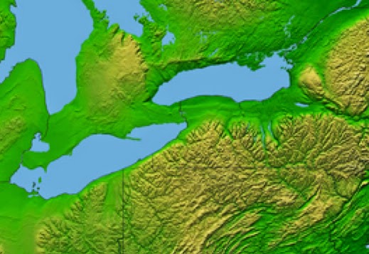
The area in the center-right of the
map lighter colored is New York. The area closer to the two lakes is Olive’s
Land of Promise. Is there any reason to think that this land would be
considered “and thus the land of Nephi and the land of Zarahemla were nearly
surrounded by water” (Alma 22:32)?
Again, another erroneous
statement. Of course seas are mentioned—actually two of them—since the entire
idea of the water mentioned in vs 32 is in regard to these two seas: “from
the east to the west sea; and thus the land of Nephi and the land of Zarahemla
were nearly surrounded by water” (Alma 22:32). It is always suspect when
someone quotes a scripture inaccurately or only partially, especially by
quoting only that part that agrees with their point.
The
point is, when you start off with the end result already determined, you make
concessions with the scriptural record since it seldom agrees with such
theorizing. In the case of Olive, instead of seeing what the scriptural record
had to say and what it meant, she was forced to try and fit Mormon's information into an area she
had already decided upon. In Olive’s case, she is forced to claim the Hill
Cumorah is to the east of the East Sea in opposition to Mormon's descriptoin, and far to the east of Zarahemla and
Bountiful, and north of the Land of Many Waters (which are east of Zarahemla
and Bountiful)--all of which is contrary to the scriptural record.
In her theory of land locations, nothing
fits where Mormon placed it; however, still undaunted, Olive goes on to make her case
that this was the Land of Promise. The problem, once again, is that once an end
location is determined, the fact that the scriptural record does not agree with
it does not alter the opinion of that being the Land of Promise.
Take
John L. Sorenson’s Mesoamerica location. Despite the directions of Mormon’s
descriptions being very clear, Sorenson goes on to use an east-west directional
land rather than the north-south directional land of the scriptural record. Despite
the narrow neck of land being the width a Nephite could cross in a day and a
half, he uses a land where the narrow neck would take four or five times that
long to cross.
This
is what happens when a theory is developed and the starting point is the end
location.
In
another example, Olive, Covino and Coon, as well as all those who place the
Land of Promise in the eastern United States, either around the Great Lakes or
the Mississippi valley, either location Lehi could never had reached by ship.
Oceanographers, hydrologists, water management experts, researchers and
historians have all made it clear that the early inland rivers of the eastern
United States, including the Mississippi River and the St. Lawrence River (in Canada),
could not be used for interior sailing to any great distance, most to no more
than a few miles.
Top: Mississippi River rapids;
Bottom: St. Lawrence Rapids. Not until the 1800s were many of the U.S. inland
rivers negotiable, and many others not until the 1900s
Not
until the early settlers (Erie Canal, etc.), the Royal Army Engineers of Canada
(St. Lawrence Seaway) and the U.S. Army Corps of Engineers (Mississippi River,
etc.) dredged, dug, altered, diverted, etc., inland rivers, were ships of any
kind able to sail even to within walking distance of the Great Lakes because of
numerous shallows, rapids, whitewater, falls, cataracts, etc., that blocked
even movement by canoe (see the numerous earlier posts on this subject).
So let us say that again: when a theorist decides upon a location, then tries to fit the
scriptural descriptions to it, they have to
bend, change, alter, or eliminate the scriptural descriptions in order
to make Mormon’s Land of Promise fit their pre-determined model. Also, as
shown, they often hang their entire model and theory on a single issue, yet
there are numerous descriptions of the Land of Promise given by Nephi, Mormon,
and others (see "So Where is the Land of Promise?" Parts I thru XII, posted between December 26, 2013 and January 7, 2014).
We
have spent much time on this blog to show how Theorists many claims and models
simply do not fit the scriptural record. It has nothing to do with what we show
as the Land of Promise—but whether or not ideas match the scriptural record. If
they do not match without making drastic changes, then they simply are not
accurate.
Continuing with the comments that
have been received regarding the most recent series we have posted on the
Jaredites.
Comment #1: “In the Book of Ether when
it says, ‘And they built a great city by the narrow neck of land, by the place
where the sea divides the land,’ what “land” is being referred to? Was the land
Northward divided? I see nowhere else where that subject is raised”
Jamie J.
Response: In the lifetime of Lib,
who reigned as king in the place of Kish after the latter’s death, the Land
Southward had become covered with animals, which were driven there by the
poisonous serpents. At the time of Lib, the serpents were destroyed, either by
natural events, or that the Jaredites had finally wiped them out where they had
assembled to “hedge up the way” (Ether 9:33) into the Land Southward—evidently
at the narrow neck of land. When they found this land to the south was now full
of animals and a great place to hunt, they decided to preserve it as a wilderness
(unoccupied or unimproved land) so they could go there and easily hunt and get
game (Ether 10:21). At the same time, they decided to build a city by this
“narrow neck of land,” maybe some type of hunting lodge or “southern palace”
for the king (who had become a great hunter) that eventually expanded into a
city—a great city, perhaps like many another Jaredite “mighty city” which had
been built ten generations earlier in the time of Coriantum (Ether 9:23), or
eight generations earlier in the time of Heth, or Moriantum five generations
before Lib (Ether 10:12).
In any event, this city was
located “by the narrow neck of land” that divided the land.
This narrow neck of land is that
same “small neck” mentioned by Mormon as connecting the Land Southward with the
Land Northward (Alma 22:32). Naturally, a neck or narrow strip of land between
two major land areas would have an inlet of water or part of the sea flowing on
both sides between the land mass to the north and the land mass to the south,
thus “dividing the land.”
The “sea that divides the land” is that area of the West Sea and or the
East Sea that cuts into the land to form the narrow neck of land between the
Land Northward and the Land Southward
This division is the only land
division mentioned in the entire scriptural record: “there
being a small neck of land between the land northward and the land southward”
(Alma 22:32). Thus, the statement in Ether 10:20 could read: “And they built a
great city by the narrow neck of land, by the place where the sea divides the
land northward from the land southward.”
Thus,
any Theory that tries to set forth a location for the Land of Promise must have
an area where the Land Northward and the Land Southward are separated by a sea
(not a lake or river or waterway, but a sea. This is obvious since Mormon is
telling us earlier in the same sentence that “the line Bountiful and the
land Desolation, from the east to the west sea,” created a body of water that
“nearly surrounded the land of Nephi and the land of Zarahemla (Alma 22:32).
Comment
#2: “In Omni 1:20 it says that the record
of the Jaredites was found engraved upon a large stone. Yet, in Mosiah 8:9 it
says that the Jaredite record was found written upon 24 plates. Do we have two
different accounts of the Jaredites, or just one? I’ve never heard of a second
account” Ingrid G.
Response:
The account in Omni 1:20 has to do with a brief writing by Coriantumr, the last
Jaredite (other than Ether), who wrote down his own, brief history shortly
before dying in the Mulekite camp after the final battle where he killed Shiz.
He had wandered there in fulfillment of the prophecy given him that he would
live after seeing his people all killed only long enough to see another people
inherit the land. We do not have this account written anywhere, but understand
it to have been just a brief history of Coriantumr and his people, perhaps his
time as king, etc.
Coriantumr, wounded, fatigued, and no
doubt still suffering from his wounds received in his final battle with Shiz,
and probably heavy-hearted at all he had done in the annihilation of his
people, wandered into the Mulekite camp—he would be dead within nine months
The
account in Mosiah is what we have as the Book of Ether, which Moroni abridged
from the collection of plates that had been kept by the Jaredites of their long
history, from the time of the Tower and their leaving Mesopotamia down to the
time of their last battle and annihilation.
Comment
#3: “I understand that there were
‘shining stones’ mentioned in the ancient Palestine Talmud, claiming the Ark
was illuminated with a miraculous light-giving stone that supposedly glowed for
twelve months inside the Ark and would dim during the day so Noah would know it
was daytime. Was that where Joseph Smith got the idea of lighting the Jaredite
barges?” Conrad A.
Response:
Hugh Nibley pointed out that the four copies of the Palestine Talmud that
mention the Ark’s shining stones, two appeared 30 years after Joseph had
already translated the Book of Mormon, and when the book was published, not a
single translation of the Palestine Talmud was available in any modern
language.
On
the other hand, since it was the brother of Jared who came up with the idea,
carved out the stones, and presented them to the Lord (fearful the Lord would
take offense), one might conclude that he, the brother of Jared, was familiar
with the concept of the stones from his 3rd great grandfather, Noah,
who was alive during his lifetime (Noah died in 1998 B.C.) Perhaps the brother
of Jared got the idea from Noah himself, or at least had heard about it from
his father or grandfather as handed down in family tales that recounted the events of the Flood.
Comment
#4: “I find it way beyond belief that
eight separate barges, driven before the wind, afloat for 344 days, covering
thousands of miles, would all land at the same place on the same day as
described in your Book of Ether” Bowen K.
Response:
The scriptural record states: “And they
did land upon the shore of the promised land” (Ether 6:12). There is no
mention or suggestion they all landed on the same day or in the same place. The
next sentence reads: “And when they had
set their feet upon the shores of the promised land they bowed themselves down
upon the face of the land, and did humble themselves before the Lord, and did
shed tears of joy before the Lord, because of the multitude of his tender
mercies over them” (6:12).
All
of this only says that when the Jaredites landed and came ashore (not where
they came ashore or when they came ashore), they were grateful for reaching
their destination and the Lord taking care of them in the process. There is no
suggestion they did this at the same time, or even together. Say there is a
modern day shipwreck and 12 lifeboats are lowered and filled with passengers.
Terrible storms separate them and one by one they each make their way to an
uninhabited land, each beaching on the sand, perhaps miles apart, after several
days of privation at sea. Do you not think that each person in each lifeboat,
unbeknownst to the others might not come ashore and be thankful in their own
way for their preservation? If three lifeboats landed within sight of each
other, would they want to join together in a common hug before expressing their
gratitude to their God? Hmmm, I think you are making a mountain out of a tiny
grain of sand here.
Remember,
Moroni’s translation and abridgement of the Jaredite record is not an ongoing
moment-by-moment narrative, but a compilation of what he had read of any one
incident. Look at his next verse: “And it
came to pass that they went forth upon the face of the land, and began to till
the earth” (Ether 6:13). Does this suggest that it was the exact same
moment after they landed? Or does it suggest that after landing, after
unloading, after making arrangements on the land for living space (setting up
tents or constructing shelter), looking for drinkable water needed for
survival, hunting for fresh game, fixing meals, taking care of household needs,
children and babies, feeding the animals, etc., etc., etc., that they then started tilling the ground and
planting their seeds?
Notice
that these two sentences are one after the other, yet no doubt much time would
have passed between these two stated events. And no doubt some time had passed
between the first barge landing and the last barge landing and the numerous
Jaredite parties from each barge located each other and formed their community
in the promised land.
Any group of people moving into an
area, even temporarily, will set up a campsite, perform household needs, look
to immediate food, shelter and water needs before thinking long term
One
of the things critics or questioners of the record might want to do before being
so vocal about uttering their critiques, is to try and understand what is
written in any abridged record—where much, out of necessity, is left out.
Continuing with the comments that
have been received regarding the most recent series we have posted on the
Jaredites.
Comment #1: “The
Jaredites are said to have existed between 2700 BC, when they traveled to
America, and 600 BC, when they succumbed to civil war, yet you write about
dates 400 to 600 years later. How do we correlate these dates?” Sally A.
Response:
There are all sorts of dates that different Theorists have projected as to when
the Jaredites existed. John L. Sorenson and many other Mesoamericanists use
dates that are in line with the Popol Vuh—a
text corpus of mytho-historical narratives of the Post Classic K’iche kingdom
in Guatemala, which places the Jaredites as early as 3100 B.C. However, in this blog, we use the scriptural record for all dates
and events, whether Biblical, Jaredite or Nephite.
In
the Bible, Noah was 500 years old when he began the Ark (Genesis 5:32), and one
hundred years later, when he was 600, he finished (Genesis 7:6). “In the six
hundredth year of Noah’s life, in the second month, the seventeenth day of the
month, the same day were all the fountains of the great deep broken up, and the
windows of heaven were opened and the rain was upon the earth forty days and
forty nights” (Genesis 7:11). In going back over the births and ages of the
Patriarchs (Genesis 5:3-32), this places the Flood beginning in 2344 B.C.
(using the start date of 4000 B.C. when Adam left the Garden of Eden). The
Flood then ended one year and three days later (Genesis 8:14).
Using the sectarian accepted dating
of the Patriarchs, and beginning with Adam’s age at 4000 B.C., Noah would have
been 600 years old in 2344 B.C., the time of the Flood—he lived 350 years after
the Flood (Genesis 9:29), dying in 1998 B.C.
Continuing
with the births of Shem’s lineage, down to the birth of Peleg (Genesis 10:25),
and placing Jared and his brother within the lineage of Peleg’s younger
brother, Joktan, this means that the Jaredites would have lived in the 22nd
century B.C., and left Mesopotamia sometime around the late 2100s (see the book
Who Really Settled Mesoamerica for a
complete chronology and date breakdown of the Jaredites, and why this date is
placed at 2116 B.C.)
Consequently,
we use the round-figure date of 2100 B.C. as the time frame of the Jaredites
arriving in the promised land.
Comment
#2: “I have always been curious what drove horses to extinction in the Americas? Did humans have a hand in their demise, or did climatic change and altering vegetation trigger it?”
Zonnie B.
Response:
A
definitive answer to this questions has eluded scientists for centuries.
Science claims that the end of the Pleistocene epoch—the geological period
roughly spanning 12,000 to 2.5 million years ago, coincided with a global
cooling event and the extinction of many large mammals. They claim that evidence
suggests North America was hardest hit by extinctions.
They also claim this
extinction event saw the demise of the horse in North America. The species survived,
they believe, only because the Bering land bridge that once connected Alaska
and Siberia (another scientific assumption) had enabled animals to cross into
Asia and spread west (which is in the opposite direction that people are claimed to have spread from the Old World to the Western Hemisphere, which seems like a rather opportune hypothesis to answer this question).
In addition, the end of the
Pleistocene is also credited with the end of the woolly mammoth, American
camels, dire wolves, short-faced bears, saber-toothed cats, stag-moose, woolly
rhinos and giant ground sloths.
Horses have always flourished on the
American continent, developing the wild mustang that roamed most of North
America
However,
the unanswered
question has always been, and still is, "why could the continent that gave rise
to the horse no longer provide a suitable home?" What is the rationale behind
the horse no longer able to survive on a continent where horses have always
flourished?
The only feasible answer is that
Noah’s Flood wiped out all animal life on the entire earth except what was in
the Ark. However, science will never follow that line of thinking. So they
struggle from generation to generation not able to answer one of the most
important questions facing zoology, yet still maintain that there were no
horses in the continent where horses have always flourished.
The American Bison, or buffalo, has survived in North America for what science claims is
between five and ten million years, co-existent with the horse
After all, it should be kept in
mind that the America bison, which lived before the extinction (found in the La
Brea Tar Pits along with the horse), and lived after the so-called horse
extinction, continued to flourish on the continent until wiped out from hunting
by man in the 19th century. It is interesting how science claims one became extinct from natural causes and the other did not.
Commit #3: “In your Jared story-line, the Lord directed the brother of Jared to build barges to
take him and his family on a year-long voyage to America. They would also take
aboard a variety of creatures…doesn’t that sound familiar? No originality there.
Sounds like someone borrowed the idea from the Bible”
Pieter M.
Response:
How odd that the same being that told Noah to save animals for the repopulating
of the earth also told the brother of Jared to take some of those same "saved" animals
across the oceans to repopulate the Western Hemisphere. Hmmm. Let’s say you
create a plan to start up a business that becomes very successful, then a few years later, you want to start
up another business. Do you reinvent the wheel, or use the same plan with some
slight modifications?
Comment#4:
“Correct me if I’m wrong, but one hole
wouldn’t have provided enough air for an entire barge. Closed spaces (such as
watertight vessels) don’t draw in a lot of air, because they’re already full of
it. And due to the body temperatures of the Jaredites and the animals, the
barges would be full of high-pressure warm air trying to exit the hole such
that fresh air could not enter” Walker R.
Response:
The principal you state is correct; however, there were two holes (Ether 2:20), which have been illustrated in this blog
several times. They were set or cut top and bottom (fore and aft) creating a
perfect cross-ventilation. Did you read the blog, or just decide to weigh in
with other critics' arguments?
Comment
#5: “One might also reasonably wonder,
for example, whether the ‘small barges’ could have held a years-worth of food
for the Jaredites and their animals, bird, fish, and bees” Gifford T.
Response:
Eight vessels, approximately 100 foot long by about 50 foot circumference,
would provide space of about 52,000 cubic feet per vessel. Each vessel would
contain about 16 people (16x8=128). Each vessel could contain one elephant, and
pairs of horses, camels, sheep, cows, goats, etc., and a beehive, cage of birds
and barrel of fish. When broken down, it is not a large number of animals, and
in 52,000 cubic feet of space (416,000 cubic feet overall), a lot of food could
be stored without it hindering the living spaces of the occupants.
Comment
#6: “Who were the warring nations of the
Steppes the Jaredites were supposed to be part of according to Hugh Nibley?”
Samantha W.

Response:
The first people of the Steppes as far back as can be accounted were the
Scythians. Scythia was the region to the north and northwest of the Black Sea
and the people called themselves the Skoloti and the Greeks called them
Scythians. They originally came from Mesopotamia. They were considered
barbarians, but repelled Alexander the Great’s army as well as the Persian
invasion of Darius’ troops—however, they existed only between about 800 and 200
B.C. Around 600 B.C. a group called the Sarmatians (introduced in the recent movie King Arthur) appeared (also known as
Colchis). When Nibley tries to place the Jaredites among the Steppes, he seems
to be forgetting two very important things—the steppes were about 1000 miles to
the north and east of where the Jaredites were always located, and the time
frame of the warring tribes is about 1500 years after the Jaredite period.
Continuing with the comments that
have been received regarding the most recent series we have posted on the
Jaredites.
Comment #1: “How silly is the idea that a rock can glow with light? Couldn’t your
Joseph Smith come up with a better solution?” Ricardo B.
Response: This was answered in
part in a previous post regarding radiluminescence. (“Another Interesting View-Part III, Thurs Feb
5). In addition, we might add that all minerals
have the ability to reflect light, which is what makes them visible to the
human eye—and a few minerals have an interesting physical property known as
"fluorescence." These minerals have the ability to temporarily absorb
a small amount of light and an instant later release a small amount of light of
a different wavelength. This change in wavelength causes a temporary color
change of the mineral in the eye of a human observer. The color change of
fluorescent minerals is most spectacular when they are illuminated in darkness
by ultraviolet light (which is not visible to humans) and they release visible
light.
Fluorescent rocks. Actually, anything
that is visible to the naked eye is capable of reflecting light. These rocks
absorb light at a particular wavelength, and then release the light at another
wavelength
This
fluorescence occurs when the mineral is illuminated with specific wavelengths
of light—ultraviolet, x-rays and cathode rays are the typical types of light
that trigger the fluorescence. They excite susceptible electrons within the
atomic structure of the mineral and the excited electrons temporarily jump up
to a higher orbital within the mineral's atomic structure. When those electrons
fall back down to their original orbital a small amount of energy is released
in the form of light—called fluorescence. This wavelength is
often distinctly different from the wavelength of the incident light, and the
“glow” continues as long as the mineral is illuminated with light of the proper
wavelength.
How
the Lord affected the stones he touched is not known, however, the point is, the
Jaredite rock-light is not only believable, but can be done within our own
knowledge, making it not “silly” but understandable—a fact that would not have
been known to Joseph Smith in 1830.
Comment #2: “If horses existed in
ancient Mesoamerica during the Book of Mormon time period, then despite the
fact that ancient Mesoamericans depicted many animals in art and ideology, they
never depicted a horse or included the horse in any of their mythology. And if
the horse existed in Mesoamerica since Jaredite times, then it left no trace of
the sort of social evolutionary impact that we see in other cultures that
possessed the horse” Clement R.
The tar pits located in Hancock Park
before any interest in them was known and construction later started
Response:
It is interesting that of the animals found in the ancient oil seeps of the
Rancho La Brea Tar Pits (not far form where I grew up), now part of the Hancock
Park, in the Fairfax District, was one we call the llama. Not discovered until 1769, when the Portolà expedition of
Spanish explorers chanced upon them and called them Los Volcanes de Brea (“the Tar Volcanoes”) because of the
geyser-like eruptions. It was not until 1901 that the bones discovered from
time to time in the tar pits were actually fossils when W. W. Orcult, a Union
Oil geologist, chanced to see them.
Not
until the 1940s and 1950s were bones actually shown to the public and
excitement generated about these ancient fossils that had been trapped in the
tar formations over the centuries. In 1975, more than twenty-five years after I
first saw and explored the pits, a museum was built beside the park on Wilshire along the
famous Wilshire Miracle Mile, where I worked for several years.
The La Brea Tar Pits (Museum in
background) depicting some of the many animals that had died there over the
years and their fossils later discovered
In
2009 the George C. Page Museum formally announced the discovery (three years
earlier) of 16 fossil deposits which had been removed from the ground during
the construction of an underground parking garage.
These
finds included a saber-toothed cat, wolves, bison, horses, a giant sloth, domestic
dog, a lion and several small animals. Everything found in the tar pits dates
to pre-historic times, often given outlandish ancient ages of the oldest being
38,000 years.
It
is interesting that insect bites on the lower leg and foot bones on many of the
large animals found in the pits, including horses, have been identified as dernestrud and tenebrionid beetles, which
still crawl all over Southern California today, yet have been identified as
having left the trace marks on the entrapped animals before they died, or at
least before they were buried in the tar—which would have occurred in a period of only 17 to 20 weeks after being entrapped.
A painting depicting the entrapment
of one of the horses found in the pits. Wolves and a cat are sneaking in for
the kill, only to be later entrapped themselves
“It
is kind of surprising to find out what kinds of insects did this damage to the
bones,” Blaire Van Valkenburg, a paleontologist at UCLA stated. It is also
noteworthy that a human skeleton was found in the tar pits, referred to as La
Brea Woman, who was 17 to 25 years of age when trapped in the tar some 10,000
years ago.
The
point is, there are three very important issues at hand here: 1) The horse
mentioned earlier found in the tar pits; 2) A human skeleton found in the pits
during the same time period; 3) A llama found there, considered to be the
forerunner of the llamas that later migrated to South America in the Great
American Interchange (the latter being the period when Panama became connected
to South America). Since these periods coincide with occupation of the Americas
after the Flood, and at the time of the rising of Panama above the ocean
surface, it can be placed in the time frame of the Nephite nation as
illustrated in several earlier posts.
La Brea Woman replica skull on
display in the Santa Barbara Museum of Natural History
The
fact that people lived at the time of these fossils cannot be disputed, since a
woman’s bones were found in the same environment. And also is the fact that
North America animals did not show up in South America (and vica versa) prior
to when the Panama connected occurred also places this event during the time of
the Nephite nation.
The
American bison (bison bison) is claimed to have not evolved or existed prior to
5,000 to 10,000 years ago. It seems when you cut through all the evolutionary
dating and get to the heart of the matter, these animals and people all seem to
have a very recent time existence. For those who accept Moses time frame of the
creation and earth’s existence as described in Genesis and the Pearl of Great
Price, again, this coincides with the Nephite nation in the Americas.
Those animals that were not taken on
the Ark died in the Flood. “All
flesh died that moved upon the earth, both of fowl, and of cattle, and of
beast, and of every creeping thing that creepeth upon the earth, and every man“
(Genesis 7:21)
The
one thing we have to be careful of as readers of the scriptural record is that
all animals all over the world became extinct in 2344 B.C. as the Flood waters
rose about the mountain tops. What animals Noah had on the Ark are those that
were available to repopulate the animal kingdom—this is a fact you will never
find in any scientific community, magazine, discussion or article. It does,
however, inarguably change the entire concept of animal kingdom, phylum, class
or order, etc. as now known in zoology.