Monday, January 31, 2011

Is Baja Choice Above All Other Lands? Part III

David Rosenvall writes of his Baja California model in his website that “Three other areas of evidence are also basic.” The first two were covered in the last two posts. Here we will take a brief look at his third point.

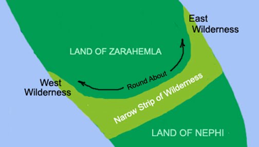
“The third is the basic and pivotal location of the river Sidon. This river is a key feature of the Nephite realm in the Book of Alma, and is the only river mentioned by name in the Book of Mormon account. Several locations are described in relationship to the river Sidon. For example, the oft-mentioned and seemingly unique feature called the head of river Sidon, as well as the city and land of Zarahemla, the hill Amnihu and the hill Riplah. If the river Sidon and the head of the river Sidon can not be located precisely and confidently, and with convincing evidence, then it significantly weakens any geographical proposal.”

In the six earlier posts entitled: “The Baja Theory—Does the River Sidon Flow North or South?” the direction of flow was shown to be from the south to the north, from the south wilderness strip where the head of the river Sidon was located (near the land of Manti) and that it flowed northward past the city of Zarahemla as the scriptural record indicates.

There seems little need here to debate further this simply stated feature. And contrary to Rosenvall’s belief, the record does state clearly where the head of the river was located and that it did flow northward, not southward as his model requires.

Rosenvall further writes: “We would suggest this as the key evidence: In our proposal all possible geographical features and descriptions appear to match the proposed area 100 percent. This border to border and top to bottom alignment of features seems to us as far more significant than any single evidence or set of evidences.”

Unfortunately, very few features of the Baja peninsula match any part of the record of the topography and geography of the Book of Mormon. Simply saying it does, is not sufficient. Actually scripture needs to be cited correctly and followed through.

Quoting Rosenvall: “The first is the implication of the Lord’s words to both the Jaredites and the Nephites that they had been sent to lands which were “choice above all other lands of the earth.” This direct and unambiguous statement, by its very superlativeness, would exclude most locations on the earth and include only a few.” Obviously, Baja California simply does not fit the requirements. Of all the land in the Western Hemisphere, few places could be less desirable and choice than Baja California if you exclude the coastal beaches. Inland, Baja and Baja Sur are about as inhospitable area for settlement, let alone choice lands, as anywhere that can be found outside the near arctic reaches of northern Canada and Tierra del Fuego in Chile, or the deserts of the southwest.

Left Map: Early Spanish Missions; Right Map: Today’s Major Cities.

Of the 28 missions established by the Catholic Church in early Baja and Baja Sur, 19 were along coastal areas, with only 9 inland, and 6 of those in the southern part of the peninsula where water was more available because of the rainy seasons. The other three inland missions were in the Mediterranean inland of the north. Even today, of the 13 most populated city areas, 11 are on the coast. Only Mexicali, along the U.S. border and San Ignacio, are inland. Within these 13 cities are 95% of the peninsula’s total population.

Lastly, it might be said, that all artifacts of earlier life on the peninsula date to a very backward people who left behind nothing of note other than rock wall paintings (which date to 500 A.D. about the same time as the Mayan ruins at Copan), no buildings, ruins of any kind, forts, palaces, temples, or other kinds of settlement. From the B.C. period come artifacts of basalt choppers and scrapers, obsidian projectile points, and sandstone manos and metates, bone awls and deep scapula “saws.”

Thus, from the last three posts, we can see that Rosenvall’s claim that Baja California matches the scriptural requirement of the Land of Promise in the Book of Mormon is without merit.

Sunday, January 30, 2011

Is Baja Choice Above All Other Lands? Part II

Continuing with the previous post, Rosenvall has set three criteria as his most important factors to determine the Land of Promise. In the last post the first, being “choice above all other lands” was covered. In this post, the second point is listed. As Rosenvall wrote:

“The second area is scale. The scale of the Book of Mormon lands, as measured in days of travel, must match actual distances within any proposed location on the earth’s surface.”

This is a favorite concept among all theorists it seems. They love to gauge travel times in the scriptural record and equate it to distances. However, there is not a single incident in the entire Book of Mormon where two distinct travel points can equate to a specific time. The only one that even comes close is the 21 days it took Alma and his group to travel to Zarahemla. All theorists consider that it took this 21 days to travel from the city of Nephi to the city of Zarahemla. However, the record shows they did not start out from the city of Nephi, but the Waters of Mormon, which “was in the borders of the land” (Mosiah 18:30-31). From here “they took their tents and their families and departed into the wilderness” (Mormon 18:34).

Nor does the record show that they arrived after 21 days of travel at the city of Zarahemla, for as Mormon wrote of Alma after having traveled nine days already: “And after they had been in the wilderness twelve days they arrived in the land of Zarahemla” (Mosiah 24:25)

That is, they “arrived in the LAND of Zarahemla.” Since we do not know how far the borders of the land were from the city of Zarahemla, nor how far the Waters of Mormon were from the city of Nephi, we can do no more than calculate that the distance between the borders and the waters took 21 days.

But even so, how long would it take about four hundred and fifty people (Mosiah 18:34) with their tents, and probably some provisions and maybe even flocks, to travel in a day? The Mormon pioneers coming from Far West to Salt Lake valley were said to have average 8 miles per day. That would make the waters of Mormon 168 miles from the borders of the land of Zarahemla. On the other hand, it is also said the pioneers average about 11 miles per day across the flat plains, making their travel time in the mountains far less than 8 miles per day.

On a level, unobstructed plain, it is said that a person could average about 2.5 miles an hour. Over a twelve-hour period, that would be 30 miles in a day (making the distance above about 630 miles). Scaling mountains, cliffs, and other terrain, could reduce that travel time to less than a mile per hour, or about 10 miles a day (a distance of about 210 miles). Fording streams, looking for sand bars to cross, building any kind of rafts, bridges, or other physical needs, could reduce travel time considerably. Going uphill would slow one down, going down hill might speed up the pace.

The question is, how can anyone know how far a person or group could travel in a day when we do not know the type of terrain crossed, nor the specific difficulties encountered?

The answer is obvious. This cannot be determined. We can assume the distance traveled averaged so many miles in a day, but that is merely an assumption—and as such, not qualified to determine distances to any degree at all.

In addition, even if the distance between the city of Nephi and the city of Zarahemla could be determined, that would not help to know how far it was from the city of Nephi to the land of first inheritance in the south (Lehi’s landing place), nor how far it was from the city of Zarahemla to the city of Bountiful. Nor do we even know how far the city of Bountiful was from the narrow neck of land, nor how far that narrow neck was from the Land of Desolation. Nor do we know how far it was from that narrow neck to the Land of Many Waters.

Nor do we know how far it was from the East Sea to the West Sea. We only know that the narrow neck of land could be crossed in a day and a half by a Nephite, presumably on foot—which makes that distance about 25 to 30 miles average 2.5 miles per hour for about 12 hours, or 50 to 60 miles in 24 hours (1 ½ days of travel time). On the other hand, if the terrain was mountainous, we are looking at about 1 mile per hour average, which brings that distance down to about 25 miles.

As one can see, the variables involved in trying to place distances of travel and mileage involved is impossible to calculate with the little information known from the scriptural record. Presumably, and it seems almost certain from the record, that the Land of Promise was much longer north to south, than east to west. But other than that, no distances can be calculated with any degree of accuracy.

Therefore, “the scale of the Book of Mormon lands, as measured in days of travel, must match actual distances within any proposed location on the earth’s surface” is of no value whatsoever. If someone tries this, they are merely guessing, and when such guesses are driven by a need to prove a model, then they are completely worthless.

(See the next post, “Is Baja Choice Above All Other Lands? Part III,” for the other criteria Rosenvall has set for the Land of Promise, including the river Sidon)

Saturday, January 29, 2011

Is Baja Choice Above All Other Lands?

David Rosenvall writes in his website that “Three other areas of evidence are also basic. The first is the implication of the Lord’s words to both the Jaredites and the Nephites that they had been sent to lands which were “choice above all other lands of the earth.” This direct and unambiguous statement, by its very superlativeness, would exclude most locations on the earth and include only a few. It is essential, therefore, that the justification for any proposed location should include evidence of a highly desirable climate, plants and animals, and the obvious advantages of the proposed environment over other locations.”

So let’s take a look at each of these statements Rosenvall makes about the Land of Promise and compare it against his Baja model.
1.” Choice above all other lands”

Baja California is divided into two distinct parts, Baja and Baja Sur, both states of Mexico, and are both similar in most ways with a few exceptions. First, the northern part, Baja California, which is divided from Baja California Sur (like Virginia and West Virginia—there is no East Virginia) along the 28º north latitude, just south of Rosenvall’s narrow neck of land. In the far north, from Tijuana to Mexicali, live 75% of the people because the climate there is Mediterranean; however, as you go southward, the temperature rises and the terrain becomes more rugged. The beaches are magnificent, from Rosarita to San Felipe and Ensenada are paradisiacal—however, get away from the beaches and the climate is harsh, rugged and rocky. The central and southern sections are home to remote and extremely desolate deserts which include substantial mountains, large sand dunes, towering cacti and dormant volcanoes projecting an almost alien landscape.

Climate and Vegetative regions: Green: Mediterranean Climate; similar to southwest U.S. and southeastern California (light green high elevations with coniferous forests); Blue: Hot and Arid; a “true desert” with desert-type plants (light blue area much drier and more sparse); Red: Tropical hot and humid; more rainfall, still desert, but with more densely-packed plants

2. “A highly desirable climate”

Like any desert, the climate is dry, with annual rainfall averaging 9-inches around Tijuana and 11-inches around Rosarita—with less rainfall in the interior. In the northeast and the south, the climate has wide temperature differences between the hot days of over 100º F. and the very cold nights. The center of the state is cooler, with cold winters (when most of the rain falls) and cool summers. In the south, the weather is tropical, hot and humid. The east coast is hotter than the west, and in the extreme south it receives about 10 inches of rain. The entire peninsula has little water and often is faced with year long or multi-year droughts where rain of less than 1-inch falls. While most people enjoy the coastal areas where 95% of the people live (other than Mexicali area), with its mild climates at certain times of the year, inland is another story where temperatures rise and no water exists. In the extreme north and the extreme south the climates are more tolerable, but still hot.

3. “Plants and animals”

Most of the plants throughout the peninsula are succulents. There are more varieties of succulents here than anywhere else in the U.S. Mostly desert, the Sonora covers 100,000 square miles, about 70% of the peninsula. Creosote bush and bur sage dominate the peninsula’s interior, along with numerous varieties of cactus, mesquite, paloverde, elephant trees, the boojum (cirio), cardon and saguaro—all desert flora related to the cactus family. While desert plants can be beautiful at times, this is still a harsh desert and hardly could be considered “choice above all other lands.” As for the animals, the largest are Big Horn sheep, then mule deer and pronghorns, occasional mountain lion, and a very high number of coyote. In addition there are rodents, birds, and countless snakes. However, there are no wild or domesticated animals “that are for the use of man,” on the peninsula. In fact, the only place where any kind of useful animal pre-dates the Spanish is in the Andean area of South America in the llama and alpaca, and their wild cousins, the vicuna and the guanaco.

4. “And the obvious advantages of the proposed environment over other locations.”

As has already been pointed out, the entire peninsula of Baja is not an environmentally desirable place. The weather is hot, the temperatures extreme, the soils salty and toxic, and everywhere there is very limited to non-existent water.

In one’s wildest imagination, this land, Baja California, north and south, is far from meeting even Rosenvall’s conditions as listed earlier.

(See the next post, “Is Baja Choice Above All Other Lands? Part II,” for the other criteria Rosenvall has set for the Land of Promise, including the scale (size) of the land)

Friday, January 28, 2011

The Baja Theory—Does the River Sidon Flow North or South? Part VI

This post continues with information on the River Sidon to show that the scriptural record does not describe a south flowing river Sidon as the Baja Theory demands. And as pointed out in the last post, there can be no doubt that the Lamanites, in their Land of Nephi, coming down toward the Land of Zarahemla, were in the south wilderness—that narrow strip of wilderness separating their land from the Land of Zarahemla—where just as obviously the head of the river Sidon was located (Alma 16:6). However, Rosenvall claims that the head of the river Sidon is not its headwaters. He writes on his website:

“The Book of Mormon does not mention that the river Sidon has headwaters; it states in several places that it has a head, “the head of the river Sidon.” In our discussion of the features of the river Sidon, we explain the difference between a “head” of a river as its source and the “headwaters” of a river as a source.”

Rosenvall uses the contemporary Oxford American Dictionary for his definitions, but as has been pointed out in numerous posts here, a current dictionary of current words and meanings has no value in understanding the words Joseph Smith knew and used in 1829. Consequently, the only dictionary of any value is the 1828 “American Dictionary of the English Language” by Noah Webster.

Even so, the modern terminology of “head” and “headwaters” seem quite clear. From the 14th century onward, the term “head” meant the “source of a river or stream” and sometimes used in the form “fountainhead” which means the “fountain or spring that is the head of a stream.” The contemporary definition of “head of a river” in all dictionaries used today, is defined as “the source or headwaters of a river or stream is the place from which the water in the river or stream originates.” The United States Geological Survey (USGS) states that a river's "length may be considered to be the distance from the mouth to the most distant headwater source (irrespective of stream name), or from the mouth to the headwaters of the stream commonly identified as the source stream."

Thus, the “head of a river” or the “headwaters of a river” is defined as the furthest point from the mouth, no matter what branch of the main river is considered. The Army Corps of Engineers establishes the point where headwaters begin as that point on the stream where a flow of five cubic feet per second is equaled or exceeded 50% of the time. The Oxford dictionary defines it as “Headwaters are the source of a river or stream, the literal waters which feed the river” and “a tributary stream of a river close to or forming part of its source: these paths follow rivers right up into their headwaters.”

As stated in an earlier post, the 1828 definition known to Joseph Smith was: “the principal source of a stream” and “the part most remote from the mouth or opening into the sea.”

In addition, Rosenvall makes a point that the word “headwaters” does not appear in the Book of Mormon. The reason for this might be that in 1828, according to the best known American dictionary of the day, the word “headwaters” does not even appear, suggesting that the word was not in use at that time. However, as stated above, the word “head” of a stream or river, was in use since the 14th century.

Thus we might conclude that the word “head of the river Sidon” was the correct word for Joseph Smith to use in his language in 1829, and not “headwaters.”

While Rosenvall likes to make some claims that the head of a river is different form the headwaters of a river, the point is that both (even if you want to claim them different) were in the south wilderness. There is never a mention of the Sidon River to the north of Zarahemla, nor beyond the borders to the north in the Wilderness of Hermounts, the location he claims for the headwaters of the Sidon River. Therefore, no play on words is going to change the scriptural record that shows the river Sidon commencing, beginning, having its source, within the narrow strip of wilderness separating the Land of Nephi and the Land of Zarahemla, and with the city of Zarahemla to the north of this wilderness, is there any question that the river flowed north?

Obviously, there can be no question that water flows downhill, or that rivers and streams flow downhill. The source of all rivers and streams is at a higher elevation than where one might stand anywhere along the river. If a river reaches an area that runs higher than the fall of the river, a pond or lake is created until the water rises to the height of the flow, then spills over in another downward direction. In a simple explanation, “Water can not flow up hill. It can flow over a rock if it is going fast enough, but it cannot go up hill. It needs to go down hill. It all has to do with the weight of gravitation on the water.” For water to flow uphill, one would need a pump that forces water out of it in an upward motion, or through a process called capillary action with the use of a device called a hydraulic ram—but still, once free of the pump, the water flows back downward. Obviously, then, a river will always flow downhill unless it has enough force and momentum to cause it to flow over something, such as a rock, slide, or other object, and momentarily flow upward. This, however, is not possible over any type of distance. Therefore, it is safe to say that water always flows downhill.

Now, with the river Sidon in the south wilderness, which ran from the east sea to the west sea and separated the Land of Nephi (to the south) from the Land of Zarahemla (to the north), as Mormon states (Alma 22:27), and we know that the river Sidon flows through the Land of Zarahemla, which is to the north, it stands to reason then that the river Sidon flowed northward.

Thursday, January 27, 2011

The Baja Theory—Does the River Sidon Flow North or South? Part V

Continuing with information on the River Sidon to show that the scriptural record does not describe a south flowing river Sidon as the Baja Theory demands:

In support of his claim that the river Sidon of the Land of Promise is located in a north wilderness so it can flow southward like his Baja Sur San Ignacio River, Rosenvall tries to use Alma 22:29 to say there was a wilderness to the north of the Land of Zarahemla. However, the scriptural record says nothing of the kind. Mormon wrote:

“And also there were many Lamanites on the east by the seashore, whither the Nephites had driven them. And thus the Nephites were nearly surrounded by the Lamanites; nevertheless the Nephites had taken possession of all the northern parts of the land bordering on the wilderness, at the head of the river Sidon, from the east to the west, round about on the wilderness side; on the north, even until they came to the land which they called Bountiful” (Alma 22:29)

That is, the Nephites controlled all the land to the north of the narrow strip of wilderness that separated the Land of Zarahemla from the Land of Nephi. There was a south wilderness, and short and narrow wildernesses along the coastal area of the Land of Zarahemla (round about). But to the north, there was only the Wilderness of Hermounts—a wilderness beyond the borders to the north and west. And there is not one suggestion, hint, or intimation that the river Sidon ran through this wilderness, let along had its headwaters there.

Speaking of the invading army of the Lamanites that had captured some cities along the coast in the southern regions of the Land of Zarahemla, Mormon wrote: “And now these are the cities of which the Lamanites have obtained possession by the shedding of the blood of so many of our valiant men: The land of Manti, or the city of Manti, and the city of Zeezrom, and the city of Cumeni, and the city of Antiparah” (Alma 56:13-14). It has already been established that the land and city of Manti were in the south bordering along the narrow strip of wilderness (Alma 16:6-7).

Therefore, the Lamanites were in the southern regions of the land. At this time, Helaman is writing to Moroni about his battles leading the 2000 Stripling Warriors. The Nephites had stopped the Lamanite advance, and that his young warriors had fought valiantly. He was, however, worried about the Lamanites marching around his forces and bypassing the Nephite strongholds. At this point, Helaman writes of the Lamanites:

“They durst not pass by us with their whole army, neither durst they with a part, lest they should not be sufficiently strong and they should fall. Neither durst they march down against the city of Zarahemla; neither durst they cross the head of Sidon, over to the city of Nephihah. And thus, with their forces, they were determined to maintain those cities which they had taken” (Alma 56:24-26).

Thus, we can see that the Lamanites, in the south, could not move further north into Nephite territory to capture more cities. Nor could they “march down against the city of Zarahemla” from their elevated lands in the south. Nor in their elevated position in the south wilderness cross the head of the Sidon and go over to the city of Nephihah.”

In addition, a little later Helaman describes a critical situation where the Nephites had captured so many of the Lamanites that they could not guard them in the field, and from where they were located---near the city of Manti (Alma 57:22)—they had to either kill them or send them to Zarahemla. He writes: “it became a very serious matter to determine concerning these prisoners of war; nevertheless, we did resolve to send them down to the land of Zarahemla” (Alma 57:16). That is, they were located at a higher elevation (near the city of Manti) than Zarahemla, and obviously to the south of Zarahemla. Helaman then writes about his force “for it was they who did beat the Lamanites; therefore they were driven back to the city of Manti” (Alma 57:22).

Thus we can see that the Lamanites were between Zarahemla and their own lands, which is the area of the south wilderness, the narrow strip that divides the lands, where the city and land of Manti are located. Which Manti borders the area of the head of the river Sidon (Alm 22:27).

However, undaunted, Rosenvall claims that the “head of the river Sidon” does not mean its source or headwaters.

(See the next post, “The Baja Theory—Does the River Sidon Flow North or South? Part VI,” to see the inaccuracy of Rosenvall’s claim about the river Sidon)

Wednesday, January 26, 2011

The Baja Theory—Does the River Sidon Flow North or South? Part IV – The Wilderness of Hermounts

Continuing from the last post regarding the direction of flow of the river Sidon (Alma 22:27), Rosenvall tries to confuse the placement of the head or headwaters of this river. This is because he must find a way to make Mormon’s river Sidon flow south and he does this by placing the headwaters in the Wilderness of Hermounts. As he states:

“According to the Book of Mormon account, there was not only a wilderness on the south, but wilderness areas were also located on the north, east and west of the land of Zarahemla. In the absence of evidence to the contrary, any one or more of these four wilderness areas, if they are watersheds, could be the source of the “head of the river Sidon.” Many rivers are fed from multiple upland regions. “

First, the wilderness areas to the west and east were part of the area “round about” the Land of Zarahemla—or more correctly, a way of saying that the narrow strip of wilderness curved up along both the west and east shores of the Land of Zarahemla. How far, the scriptural record does not state, but it could not have been far, since the Land of Zarahemla was the Nephite lands that “hemmed in the Lamanties on the south, that thereby they should have no more possession on the north” (Alma 22:33). As Mormon put it, “Therefore the Lamanites could have no more possessions only in the land of Nephi” (Alma 22:34).

Obviously, the head of the river Sidon was in the south wilderness. As Mormon put it, “the Lamanites will cross the river Sidon in the south wilderness, away up beyond the borders of the land of Manti” (Alma 16:6). When Rosenvall claims, “In the absence of evidence to the contrary, any one or more of these four wilderness areas, if they are watersheds, could be the source of the “head of the river Sidon.”

What more evidence does one need than Mormon’s clear and concise statement?

However, we need to take a look at Rosenvall’s claim that the Sidon River had its headwaters in the Wilderness of Hermounts. As Rosenvall states:

“We propose the wilderness of Hermounts on the west and north (Alma 2:37) as the primary source of the water at the head of the river Sidon—not because this information is in the Book of Mormon account, but because of the actual flow of the Rio San Ignacio, a river which matches all the other features of the river Sidon that are recorded in the Book of Mormon.”

Now that is really an interesting statement. He proposes the Wilderness of Hermounts “not because this information is in the Book of Mormon account” but because it matches his belief in the San Ignacio River in Baja California. Actually, nothing more need be said; however, people who think that way also ignore the scriptural record, but perhaps we should take a moment and show the relationship to this wilderness.

The Wilderness of Hermounts is mentioned only once in the scriptural record. This had to do with the Nephites battling the Amilicites who had joined with the Lamanites and were chasing the Nephites, along with their flocks, wives and children, toward the city of Zarahemla (Alma 2:25). In the battle that followed, so many Lamanites were killed that their bodies had to be cleared off the west bank of the river Sidon and thrown into the river. At this point, the Lamanites ”fled before the Nephites towards the wilderness which was west and north, away beyond the borders of the land” (Alma 2:36). And they were “met on every hand, and slain and driven, until they were scattered on the west, and on the north, until they had reached the wilderness, which was called Hermounts; and it was that part of the wilderness which was infested by wild and ravenous beasts” (Alma 2:37).

Following the battle, where “many died in the wilderness of their wounds, and were devoured by those beasts and also the vultures of the air; and their bones have been found, and have been heaped up on the earth” (Alma 2:38), there is no mention of any bodies being dumped in the river Sidon. Nor is there any mention of this wilderness being at a high elevation, nor the headwaters of the river Sidon located there, or any other river. Had the river Sidon been there, it would have been much simpler to throw the dead into the river as they did before, but instead they were left to bury those who had been slain, an amount not even counted because of the number of dead bodies (Alma 3:1).

(See the next post, ” The Baja Theory—Does the River Sidon Flow North or South? Part V,” to see how the Baja theory does not fit the simply language of Mormon in describing the land of Zarahemla, Nephi and the river Sidon)

Tuesday, January 25, 2011

The Baja Theory—Does the River Sidon Flow North or South? Part III

Continuing with the last two posts on the River Sidon, let us go over the scriptural reference given us by Mormon in Alma 22:27:
“And it came to pass that the king sent a proclamation throughout all the land—“
The king is the Lamanite King, Lamoni’s father, who was over all the Land of Nephi

“amongst all his people who were in all his land---“
His people were the Lamanites who lived in the Land of Nephi

“who were in all the regions round about---“
The Land of Nephi included the lands of Ishmael, Middoni, Shemlon Shilom (Alma 23:9-12)

“which was bordering even to the sea, on the east and on the west---“
The Land of Nephi (land of the Lamanites ran from sea to sea

“and which was divided from the land of Zarahemla---“
There was a separation between the Land of Zarahemla and the Land of Nephi

“by a narrow strip of wilderness---“
This narrow strip of wilderness separated the two lands, along the southern border of Zarahemla and the northern border of the Land of Nephi

“which ran from the sea east even to the sea west---“
This narrow strip of wilderness along the southern border of Zarahemla ran from sea to sea

“and round about---“
This narrow strip of wilderness ran around and about the southern border of Zarahemla

“on the borders of the seashore---“
This narrow strip of wilderness curved upward into the Land of Zarahemla along both seashores or coastal regions

“and the borders of the wilderness which was on the north by the land of Zarahemla---“
The northern border of the king’s land (Land of Nephi) ran along this south wilderness along the southern border of the Land of Zarahemla--the northern border of the Land of Nephi

“through the borders of Manti—“
The Land and city of Manti were to the south of the Land of Zarahemla, along the border of this narrow strip of the south wilderness

“by the head of the river Sidon---“
Along the borders of the Land of Manti and the south wilderness (which was the northern border of the Land of Nephi), were the headwaters or the source or beginning of the river Sidon

“running from the east towards the west---“
That is this narrow strip of south wilderness ran from sea to sea of the Land of Promise

“and thus were the Lamanites and the Nephites divided.”
This narrow strip of wilderness to the south of Zarahemla, which divided the Land of Zarahemla from the Land of Nephi, was the dividing line between the Nephites and the Lamanites.

Now, one would think this is perfectly clear as Mormon wrote it. However, Rosenvall’s Baja California model of the Land of Promise must change the location of the headwaters of the Sidon River to meet his model’s criteria because his river Sidon (San Ignacio River) does not run to the north, but to the south, opposite what Mormon wrote.

Which brings us to the Wilderness of Hermounts.

(See the next post, ” The Baja Theory—Does the River Sidon Flow North or South? Part IV,” to see how the Baja theory has to place the river Sidon in a north wilderness for it to flow south past the city of Zarahemla)

Monday, January 24, 2011

The Baja Theory—Does the River Sidon Flow North or South? Part II

Continuing from the last post regarding the direction of flow of the river Sidon (Alma 22:27), Rosenvall writes: “Some Book of Mormon maps place the headwaters of the river Sidon in the south wilderness, an area to the south of the land of Zarahemla on the northern extent of the narrow strip of wilderness. The proponents of these maps then reason: Because these headwaters are located towards the south, the river Sidon would, by necessity, flow northward.”

It does not matter how someone reasons—what matters is what the scriptural record tells us about the Sidon River, where it is located, where its head or headwaters are, and as a result, know where it flowed.
Speaking of this very thing, Mormon wrote: “the Lamanites will cross the river Sidon in the south wilderness, away up beyond the borders of the land of Manti. And behold there shall ye meet them, on the east of the river Sidon, and there the Lord will deliver unto thee thy brethren who have been taken captive by the Lamanites” (Alma 16:6). The map showing this is merely an example or illustration. However, from Mormon’s words, we learn:
1. We are dealing with the south wilderness
2. They were up beyond the borders of Manti (that is, they were up toward the Land of Nephi in the South Wilderness where Manti was located)
3. Manti is on the west of the Sidon River
4. The Lamanites were going to cross over to the east side of the Sidon River

“And it came to pass that Zoram and his sons crossed over the river Sidon, with their armies, and marched away beyond the borders of Manti into the south wilderness, which was on the east side of the river Sidon” (Alma 16:7). Again, we find:

1. We are dealing with the south wilderness
2. The Lamanites were beyond the borders of Manti in the south wilderness
3. The Lamanites were on the east side of the Sidon River

“They departed out of the land of Antionum into the wilderness, and took their journey round about in the wilderness, away by the head of the river Sidon, that they might come into the land of Manti and take possession of the land: (Alma 43:22). Again, we find:

1. The head of the river Sidon was in the wilderness
2. This wilderness was near the Land of Manti
3. Because Manti is in the South Wilderness, the head of the River Sidon is in the south wilderness.

This should clearly point out that the River Sidon was in the south wilderness, that is, that narrow strip of wilderness that separated the Land of Nephi from the Land of Zarahemla (Alma 22:27). And to know where the river Sidon flowed, we need to find out where the river itself was located. Mormon tells us:

“The Amlicites came upon the hill Amnihu, which was east of the river Sidon, which ran by the land of Zarahemla” (Alma 2:15). That is, the Hill Amnihu was to the east of the river Sidon, and the river Sidon ran past Zarahemla. And lastly, Mormon tells us that the Land of Nephi “was divided from the land of Zarahemla by a narrow strip of wilderness, which ran from the sea east even to the sea west, and round about on the borders of the seashore, and the borders of the wilderness which was on the north by the land of Zarahemla, through the borders of Manti, by the head of the river Sidon, running from the east towards the west.”

Thus, the south wilderness was the southern border of the Land of Zarahemla. In this south wilderness was found the head of the river Sidon. And the river Sidon ran past the city of Zarahemla. Obviously, the city of Zarahemla was to the north of this south wilderness, making the river Sidon run to the north from its head.

(See the next post, ” The Baja Theory—Does the River Sidon Flow North or South? Part III,” to see how Mormon describes this land to the south of Zarahemla and the exact wordage and meaning of the south wilderness and the head of the river Sidon)

Sunday, January 23, 2011

The Baja Theory—Does the River Sidon Flow North or South?

General term for “headwaters” in numerous dictionaries: “the source of waters of a river,” “The source or headwaters of a river or stream is the place from which the water in the river or stream originates,” “Headwaters are the source of a river or stream, the literal waters which feed the river,” “the literal source of water for the stream,” “The water from which a river rises; a source,” “the source of a stream —usually used in the plural” “the headstreams and the beginning of a large stream or river.” In Earth Sciences and Physical Geography, the definition of headwaters is “the tributary streams of a river in the area in which it rises; headstreams.” In history, we find: “the first exploration of the Missouri River from its mouth to its headwaters was made by Meriwether Lewis and William Clark in the early 1800s.”

Synonyms for “headwaters” are “head,” “headstream,” and “source.”

Alma’s description reads: “And it came to pass that the king sent a proclamation throughout all the land, amongst all his people who were in all his land, who were in all the regions round about, which was bordering even to the sea, on the east and on the west, and which was divided from the land of Zarahemla by a narrow strip of wilderness, which ran from the sea east even to the sea west, and round about on the borders of the seashore, and the borders of the wilderness which was on the north by the land of Zarahemla, through the borders of Manti, by the head of the river Sidon, running from the east towards the west -- and thus were the Lamanites and the Nephites divided” (Alma 22:27)

“By the head of the river Sidon.”

The word “head” in the 1828 “American Dictionary of the English Language,” the language spoken in New England at the time Joseph Smith was translating the plates, is defined as: “the principal source of a stream,” ”The part most remote from the mouth or opening into the sea,” “To have its source, as a river “headspring—fountain, source, origin.” It should be noted, that the word “headwaters” is not mentioned in the 1828 dictionary, suggesting it was not a term in common use as it is today. Thus, the words “head of the river Sidon” meant the same as “headwaters of the river Sidon” in Joseph’s day. It might also be noted that the word “headstream” is not mentioned in Webster’s 1828 dictionary, but “headspring” is, and defined as “Fountain, source, origin.”

As an example, in Webster’s 1828 definition of “head,” he uses the explanation: “head of the River Nile.” In the case of the Nile River, the “head” changed in ancient times. Formerly Lake Tanganyika drained northwards along the African Rift Valley into the Albert Nile, making the Nile about 900 miles longer, until blocked by the bulk of the Virunga Volcanoes. Thus, Lake Tanganyika drained northwards into the Nile until the Virunga Volcanoes blocked its course in Rwanda, and the Nile was much longer at that time, with its furthest headwaters in northern Zambia. Yet, at any one time, the “head of the Nile” was understood as one location.

One way to think about headwaters is to imagine walking along the banks of a river or stream until it vanishes. This furthest point along the river could be considered the headwaters. Some people consider the headwaters to be the furthest conceivable point from which water could flow in a watershed, whether or not the headwaters are bearing water, and as a result, the headwaters of a river may move around. Others consider the headwaters to be the furthest point that supplies water throughout the year, making the location of the headwaters a stable, static place.

In addition, many rivers have an assortment of tributaries, small branches that come together to form the river. As a result, their headwaters may be very diverse and widely dispersed, with some people calling the small streams that come together to make a river “headstreams.” Looking at a river on a map, people often find that the river looks like a tree, with a thick trunk and many forking branches with even smaller tributaries sprawled out across a drainage basin.

However, none of this changes the scriptural record of “head” in the singular “of the river Sidon.”

Yet, ever wanting to cloud the issue to make room for a different model’s situation, Rosenvall, like all theorists who choose their own ideas over that of the scriptures, wants to make the river Sidon flow southward.

(See the next post, The Baja Theory—Does the River Sidon Flow North or South? Part II,” to see how Rosenvall sees the river Sidon differently than the scriptural record)

Saturday, January 22, 2011

Use of the Term “Round About”

According to David Rosenvall’s website in his Baja California model, 'the Book of Mormon mentions two “round about” areas in relation to their lands. One is in the land of Nephi on the south and the other is near the land of Zarahemla. These two areas are easily identified in Baja California. One is the prominent circular or “round about” cape at the southern end of the peninsula, and the other is the extended “round about” cape at the mid point along the west coast near the town of Guerrero Negro, adjacent to the area we propose as the land of Zarahemla.”

However, this is not correct. Nor is the word “round about” used in any other way than how it is defined. The word “round about” as known to Joseph Smith in 1829 is literally defined as “round and about.” It means “encircling” “encompassing.”

The Land of Nephi to the south was “divided from the land of Zarahemla by a narrow strip of wilderness, which ran from the sea east even to the sea west, and round about on the borders of the seashore” (Alma 22:27) which curved upward into the Land of Zarahemla, or round about on the south of the Land of Zarahemla as shown

There are approximately 70 uses of the term—not two as suggested—in just the Mosiah and Alma chapters alone, with at least half of these relating to the land. They are laboriously included here to show that there is no manipulation of numbers or verses or meanings:

Mosiah 2:5-6 - when they came up to the temple, they pitched their tents round about… And they pitched their tents round about the temple
Mosiah 4:1 - he cast his eyes round about on the multitude
Mosiah 7:21 - having yielded up into his hands the possessions of a part of the land, or even the city of Lehi-Nephi, and the city of Shilom; and the land round about
Mosiah 10:2 - I set guards round about the land,
Mosiah 10:7 - sent my spies out round about the land of Shemlon
Mosiah 11:12 - and he could even look over all the land round about
Mosiah 11:15 - he planted vineyards round about in the land
Mosiah 11:17 - sent guards round about the land
Mosiah 19:6 - the king cast his eyes round about towards the land of Shemlon
Mosiah 19:28 - the king of the Lamanites set guards round about the land
Mosiah 21:2 - they began to come into the borders of the land round about.
Mosiah 21:20 - he caused that his people should watch the land round about
Mosiah 22:11 - they went round about the land of Shilom
Mosiah 23:25 - in the city of Helam, while tilling the land round about, behold an army of the Lamanites was in the borders of the land.
Mosiah 23:37 - they set guards round about the land of Helam
Mosiah 27:2 - sent a proclamation throughout the land round about
Mosiah 27:32 - traveling round about through all the land
Alma 12:2 - heard by the people round about
Alma 15:24: - they did flock in from all the region round about Sidom
Alma 16:15 - throughout the land, in all the region round about,
Alma 17:33 - Encircle the flocks round about that they flee not
Alma 21:13 - fled out of the land of Middoni unto the regions round about
Alma 21:21 - and in all the land round about
Alma 22:27 - which ran from the sea east even to the sea west, and round about on the borders of the seashore
Alma 23:27 - who were in all his land, who were in all the regions round about
Alma 22:29 - from the east to the west, round about on the wilderness side
Alma 22:34 - only in the land of Nephi, and the wilderness round about
Alma 24:1 - in all the land round about
Alma 28:1 - the armies of the Nephites were set round about the land of Jershon, yea, in all the borders round about the land of Zarahemla
Alma 30:32 - notwithstanding my many travels round about the land
Alma 43:22 - and took their journey round about in the wilderness
Alma 43:24 - were marching round about in the wilderness
Alma 43:28 - Moroni placed spies round about
Alma 48:8 - throwing up banks of earth round about to enclose his armies, and also building walls of stone to encircle them about, round about their cities and the borders of their lands; yea, all round about the land.
Alma 49:2 - they had cast up dirt around about to shield them from
Alma 49:4 - had dug up a ridge of earth round about them
Alma 49:13 - every city in all the land round about
Alma 49:18 - the ditch which had been dug round about
Alma 50:1 - digging up heaps of earth round about all the cities
Alma 50:2 - works of timbers built up to the height of a man, round about the cities
Alma 50:3 - a frame of pickets built upon the timbers round about
Alma 50:4 - round about every city in all the land
Alma 50:9 - in the land round about
Alma 52:6 - he kept his men round about, as if making preparations for war
Alma 52:6 - casting up walls round about
Alma 52:10 - strengthen the cities round about
Alma 53:3 - digging a ditch round about the land,
Alma 53:4 - encircled the city of Bountiful round about
Alma 55:25 - in strengthening the fortifications round about the city
Alma 56:22 - we kept spies out round about
Alma 57:6 - from the land round about
Alma 57:9 - we did camp round about the city for many nights
Alma 58:14 - they sent out their spies round about us
Alma 59:2 - in all the land round about in that part where he was
Alma 59:6 - from the land round about
Alma 60:22 - while there are thousands round about in the borders of the land
Alma 62:34 - encamp with their armies round about in the borders of the land of Moroni

Additionally, there are 3 uses in 1 Nephi; 3 in 2 Nephi; 8 in Helaman; 10 in 3 Nephi; 1 in 4 Nephi; 1 in Mormon; and 1 in Ether, for a total of 101.

It is sad that someone is so intent on trying to prove their Land of Promise model that they will force an issue with a verse or two that in no way was intended for that purpose. The term “round about” is used in every single case exactly as the word is defined by Webster’s 1828 dictionary and the way the word would have been understood to Joseph Smith when he translated the plates. Thus, there are not two references, but 101 uses of “round about,” and all convey the exact same meaning and cannot be construed to represent two specific physical land areas in Baja California.

Friday, January 21, 2011

Baja’s Isle of the Sea – Part IV

Continuing from the last three posts, while Jacob tells the Nephites “we have been led to a better land, for the Lord has made the sea our path, and we are upon an isle of the sea,” David Rosenvall in his Baja California theory disagrees with that scripture and tries to show that Mormon was describing a peninsula, not an island.

However, as stated in the last post, the word “peninsula” is not the same as the definition of the word “isle.” The word “peninsula” today is defined as “A piece of land that projects into a body of water and is connected with the mainland by an isthmus.” The word comes from the Latin “paeninsula” which literally means “almost an island.” It can also be defined as “a large mass of land projecting into a body of water,” or “a piece of land that is surrounded by water but connected to mainland via an isthmus.” In any event, a peninsula is not an island and is not translated or defined as an island.

In addition, Rosenvall writes that his Baja theory is “a narrow neck of land and a narrow strip of wilderness, precisely matches the peninsula of Baja California.

In looking at a map, the peninsula of Baja California is about the same width from beginning to end except for where it stretches along the U.S. border, where the land juts out into the Pacific at the Punta Eugenia, and a little bulge around Punta San Carlos. But for the most part, the entire peninsula is about the same width. Thus, how can it be said that “a narrow neck of land and a narrow strip of wilderness, precisely matches the peninsula of Baja California”?

This is about as disingenuous of a comment as can be made.

Why would a people of antiquity consider there to be a narrow neck of land where the land is almost the exact same width from one end to another? In geography, a “narrow neck” is meant to convey something narrower than the surrounding area, such as Central America is narrower than North and South America; a narrow canyon where the passage is limited and narrows from a wider passage; a narrow path is one that is less wide than the rest of the walkway. Narrow means narrow! And it was not the land that was narrow, but this small area that connected the Land Northward with the Land Southward.

Mormon describes this neck of land in two ways: 1) “small neck of land” (Alma 63:5), and 2) “narrow neck of land” (Alma 63:5). Consequently, this area of land was both small and narrow. Small, in this sense would mean not long from end to end, and narrow would be its width. Thus, we can see that this neck of land between the Land Northward and the Land Southward had to be a small and narrow place, and narrower than the land surrounding it.

However, in the Baja peninsula, at Rosenvall’s “narrow neck,” the distance across is 40 to 45 miles (the same approximately width of the entire peninsula), and about 100 to 120 miles from north to south.

There are also two other points regarding the living spaces in this peninsula. In the map on the left above, there are 30 cities shown—24 of them are along the coast. There is almost no population anywhere in the interior to the peninsula. In addition, the current population is centered in the far north. As an example, the land mass of the north land (Baja California) is 27,071 square miles; the land mass to the south (Baja California Sur) is 28,369 square miles, yet, there are just over three million (3,154,174) living in the north and only about half a million (637,065) people living in the south—a complete reversal of the history of the Nephites in the Land of Promise. In fact, the largest concentration of people in the peninsula is in the far north, along the U.S. border from Tijuana to Mexicali, or at the very southern tip around Cabo San Lucas to La Paz. This hardly matches the population spread in the Book of Mormon. The point is, people live where the climate, weather, and water is conducive to population settlements.

One cannot even begin to guess the general locations for the major cities described in the scriptural record, nor are there any ruins of buildings, palaces, temples, roads, etc., anywhere on the peninsula that would equate to the type of building Nephi taught his people (2 Nephi 5:15-16).

Simply put, Baja California lacks all the factors of geography Mormon described, and lacks the matching factors described throughout the scriptural record.

Thursday, January 20, 2011

Baja’s Isle of the Sea – Part III

Continuing from the last two posts, while Jacob tells the Nephites “we have been led to a better land, for the Lord has made the sea our path, and we are upon an isle of the sea,” David Rosenvall in his Baja California theory disagrees with that scripture and claims when Moroni told Joseph Smith that the Book of Mormon was a record of the inhabitants of this continent, he was excluding everything but North America. However, as pointed out in the last post, the word “continent” in Joseph’s day meant the entire western continent (Western Hemisphere).

Still, Rosenvall tries to limit the term isle as Jacob used it to describe the land upon which they had been led—the Land of Promise. He writes: “Mormon provides more detail about the shape of their lands by indicating “the land of Nephi and the land of Zarahemla were nearly surrounded by water,” except “there being a small neck of land between the land northward and the land southward” (Alma 22:32). Mormon’s description matches the definition of a peninsula, such as Baja California, as “a piece of land almost surrounded by water or projecting out into a body of water.”

This is such a ridiculous statement it hardly deserves comment, however, it cannot be left unsaid that the land Mormon was describing was the entire Land of Promise. When you read Mormon’s entire description, it starts in the Land of Nephi and covers the separation of the Land of Nephi from the Land of Zarahemla (Alma 22:27), then extends northward to the land of Bountiful (Alma 22:29), to the Land of Desolation (Alma 22:30-31), to the narrow neck of land that separated Bountiful from Desolation (Alma 22:32).

Having described this entire Land of Promise, Mormon then comes back to the Land Southward, south of the narrow neck, and describes it as “nearly surrounded by water, there being a narrow neck of land between the land northward and the land southward” (Alma 22:32). Thus, the Land Northward, is not being described at this point, however, we know that there was an eastern seashore in this northern land (Ether 9:3;14:12,26), and that there was a very large body of water to the north (Ether 15:8), which is the most northern point described, for the armies in their battles traveled south from there (Ether 15:10) into the area called the Land of Many Waters where was found the Jaredite hill Ramah—the Nephite hill Cumorah—in the Land of Cumorah (Ether 15:11;Mormon 6:4).

Consequently, at least on the east and the north of the Land Northward, there was also seas. As a result, it cannot be said, as Rosenvall claims, that Mormon is describing a peninsula. When we combine this with Jacob’s statement, then we find that the land Northward was also surrounded by water.

As for the west, we do know that the Land Northward was adjacent to the sea, for the barges the Jaredites built were “set forth into the sea” (Ether 6:4) and were blown “toward the promised land” (Ether 6:5) and “the wind never did cease to blow toward the promised land” (Ether 6:8) until finally they “did land upon the shore of the promised land” (Ether 6:12). Most scholars claim the Jaredites crossed the Pacific Ocean, and if so, then the Land Northward opened to an ocean to the west. But whether this was the east sea or the west sea, the point is that the Land Northward was open to the ocean—something Rosenvall’s Baja model does not do.

However, Rosenvall does not accept Jacob’s description of an island. He states: “This peninsular shape also agrees with the definition of an isle.” He supports this by stating: “The term “isle” is defined in the New Oxford American Dictionary as “an island or peninsula, esp. a small one.”

However, the word isle does not translate to peninsula. The word comes from the Middle English “ile,” from Old French “isle,” from Vulgar Latin “insula,” and from Latin “insula.” The Latin insula is translated as “island,” and is interpreted today by all dictionaries as “an island, especially a small one.” The word “isle” translates in Afrikans, Bulgarian, Croatian, Czech, Danish, Dutch, French, German, Greek, Icelandic, Slovak, Indonesian, Italian, Latvian, Lithuanian, Malay, Polish, Portuguese, Romanian, Russian, Serbian, Slovenian, Spanish, Turkish, Ukrainian, Vietnamese all to mean island. Such words as octpob, otok, ostrov, eiland, saar, saari, I’ile, insel, νήσος, eyja, pulau, isola, sala, kepulauan, wyspa, ilha, insula, otok, isla, adacik, octib, hòn đảo, in these languages all mean “isle” such as in the “isle of Man” or the “isle of Wight”--both separate islands surrounded by the ocean. Several other languages all translate the same, but their characters, from Japanese, Chinese, Arabic, Farsi, Hebrew, Hindi, Korean, Norwegian, Finnish, Swedish, Thai, and Urdu, are not available on this computer.

The point is, in all languages checked, the word “isle” translates the same—into island in English. However, the main point is that in 1829, when Joseph was translating the plates, the word “isle” was defined as: “a tract of land surrounded by water, or a detached portion of land embossomed in the ocean.” And as for a small island or isle, the word “islet” was defined as “a small ieland.”

(See the next post, “Baja’s Isle of the Sea – Part III,” for the final installment on Rosenvall’s Baja peninsula not being an island, and not meeting other criteria associated with Mormon’s description)

Wednesday, January 19, 2011

Baja’s Isle of the Sea – Part II

Continuing from the last post, while Jacob tells the Nephites “we have been led to a better land, for the Lord has made the sea our path, and we are upon an isle of the sea,” David Rosenvall in his Baja California theory disagrees with that scripture.

Rosenvall claims: “We do not believe the Book of Mormon people were located on a small island, but on a continental land area, because Moroni told the Prophet Joseph Smith that the Book of Mormon contained the record of the “former inhabitants of this continent, and the source from whence they sprang” (JSH 1:34).”

One of the problems that people of today have in understanding the writings of the past is in not knowing what was known then as opposed to what is known today. First of all, Joseph Smith’s words are absolutely correct and agree completely with the scriptural record. However, the word “continent” as known to Joseph is completely different from how it is known and understood today.

In the United States today, we know there are seven continents: Africa, Asia, Australia, Europe, North America, South America and Antarctica; however, in Europe, there are considered only six continents because they combine North and South America into one continent.

More importantly, in 1829, Joseph knew of two continents. That is, according to the 1828 dictionary the word continent is defined as: “continuous, connected, not interrupted,” and in geography, is described as “a great extent of land, not disjoined or interrupted by a sea, a connected tract of land of great extent, as the Eastern and Western continent.” That is, in 1828, there was the Eastern Continent (Europe, Asia, etc.) and the Western Continent, North and South America.

Thus, in Joseph’s time, the term continent, more importantly “this continent” meant both North and South America—it did not pertain to two separate western continents as it does today. Therefore, when Joseph said that Moroni told him: “the Book of Mormon contained the record of the “former inhabitants of this continent, and the source from whence they sprang,” he was referring to the inhabitants of both North and South America, and the area (Mesopotamia and Jerusalem) from which they came.

Unaware of this very important 1829 understanding, Rosenvall goes on to say, “The peninsula of Baja California, unlike an island, is an integral part of “this continent” of North America, as required by Moroni’s statement.”
Once again, Joseph knew that continent meant the entire Western Hemisphere as is shown in the knowledge of the day and the area in which he lived (see previous posts regarding Webster’s 1828 dictionary). Another area of understanding that Rosenvall seems to ignore or not know, is that the entire Western Hemisphere, that is North, Central and South America, as well as the Caribbean islands are all connected in a mass land area—in fact, the northern most point of North America is considered to be Kaffeklubben Island, a piece of land 23 miles from any land mass, and 443 miles south of the North Pole, and the southern most point is Southern Thule, part of an old sunken island between South America and Antarctica, about 1000 miles southeast of Cape Froward in Patagonia. Thus, we can see, that the land mass is both above and below sea level. As a result, any island involved in this area cannot be excluded from the land mass of the Western Hemisphere continent. After all, at any given time in history, different islands have appeared and disappeared, mountains have grown, depressions have filled with ocean water, etc., as the plate movement of this western continent has shifted. The peninsula of Baja as we now see it did not exist at one point in time, but was part of the mainland of Mexico.

It is disingenuous to claim that what we see today has always been, and the geographic terms we have become familiar with today have always existed in the same manner. And the idea and practice of using modern dictionaries to define words as they were known in 1829 is foolhardy. After all, Webster’s 1828 “American Dictionary of the English Language” is readily available to anyone, and is even available online.

(See the next post, “Baja’s Isle of the Sea – Part III,” for more of Rosenvall’s rationale in claiming that Jacob’s isle is not accurate and that a peninsula is considered an island)

Tuesday, January 18, 2011

Baja’s “Isle of the Sea”

Very few people read and understand the significance of Jacob’s comment, which Nephi recorded “the Lord has made the sea our path, and we are upon an isle of the sea” (2 Nephi 10:20). This statement, as has been pointed out many times on this site, was made as part of a discourse to the Nephites about the Lord not having forgotten those He has led away from Jerusalem, and that the Nephites had not been forgotten. The Nephites knew they were on an island—that was not the issue. What they believed, or were concerned about, was if the Lord remembered them so far away from their ancestral homeland in Palestine.

Jacob’s preaching covered a two day period (2 Nephi 9:54), beginning with the covenants the Lord made with all the House of Israel (2 Nephi 9:1), and that the Nephites had come out of Jerusalem (2 Nephi 9:5), and of the atonement and the importance of those who die spiritually, and that man will have a perfect knowledge of his own guilt, and the justice of God, and that “he knoweth all things” (2 Nephi 9:20). He spoke of the atonement, and of transgressing against the Holy Ghost, and that God “despiseth the wise, the learned, and the rich who are puffed up because of their learning and their wisdom and their riches” (2 Nephi 9:42), and that the Nephites should prepare themselves for the “glorious day when justice shall be administered unto the righteous” (2 Nephi 9:46), and that if mighty miracles had been wrought among other nations, they would repent, but the Jews had not, but would crucify him (2 Nephi 10:3-4), but “when the day cometh that they shall believe in me, that I am Christ, then have I covenanted with their fathers that they shall be restored in the flesh, upon the earth, unto the lands of their inheritance” (2 Nephi 10:7).

At this point, Jacob then talks about “And it shall come to pass that they shall be gathered in from their long dispersion, from the isles of the sea, and from the four parts of the earth; and the nations of the Gentiles shall be great in the eyes of me, saith God, in carrying them forth to the lands of their inheritance” (2 Nephi 10:8). He then goes on to describe the land upon which the Nephites were: “But behold, this land, said God, shall be a land of thine inheritance, and the Gentiles shall be blessed upon the land. And this land shall be a land of liberty unto the Gentiles, and there shall be no kings upon the land, who shall raise up unto the Gentiles. And I will fortify this land against all other nations. And he that fighteth against Zion shall perish, saith God. For he that raiseth up a king against me shall perish, for I, the Lord, the king of heaven, will be their king, and I will be a light unto them forever, that hear my words” (2 Nephi 10:10-14).

Jacob goes on to say: “For I will fulfill my promises which I have made unto the children of men, that I will do unto them while they are in the flesh” (2 Nephi 10:17), and that God will “consecrate this land unto thy seed, and them who shall be numbered among thy seed, forever, for the land of their inheritance; for it is a choice land, saith God unto me, above all other lands, wherefore I will have all men that dwell thereon that they shall worship me, saith God” (2 Nephi 10:19).

And then Jacob tells them: “And now, my beloved brethren, seeing that our merciful God has given us so great knowledge concerning these things, let us remember him, and lay aside our sins, and not hang down our heads, for we are not cast off; nevertheless, we have been driven out of the land of our inheritance; but we have been led to a better land, for the Lord has made the sea our path, and we are upon an isle of the sea” (2 Nephi 10:20). And then, referring to Isaiah’s words, added, “But great are the promises of the Lord unto them who are upon the isles of the sea; wherefore as it says isles, there must needs be more than this, and they are inhabited also by our brethren. For behold, the Lord God has led away from time to time from the house of Israel, according to his will and pleasure. And now behold, the Lord remembereth all them who have been broken off, wherefore he remembereth us also. Therefore, cheer up your hearts, and remember that ye are free to act for yourselves -- to choose the way of everlasting death or the way of eternal life” (2 Nephi 10:21-23).

The Nephites were on an isle of the sea. They had been led there by the hand of the Lord, who had made the sea their path and they had landed upon an isle in that sea.

However, David Rosenvall with his Baja California theory, says of this: “We do not believe the Book of Mormon people were located on a small island, but on a continental land area.”

(See the next post, “Baja’s Isle of the Sea – Part II,” for the rationale Rosenvall uses to ignore Jacob’s statement and try to make it something that agrees with his Baja model)

Monday, January 17, 2011

Baja’s North sea, or the Waters of Ripliancum

A sea to the north is mentioned only twice in the scriptural record. First in Ether, we find that a very large body of water was to the north: “Coriantumr saw that he was about to fall he fled again before the people of Shiz. And it came to pass that he came to the waters of Ripliancum, which, by interpretation, is large, or to exceed all; wherefore, when they came to these waters they pitched their tents” (Ether 15:7-8). The second one is in Helaman: “and did spread insomuch that they began to cover the face of the whole earth, from the sea south to the sea north, from the sea west to the sea east” (Helaman 3:8).

According to Rosenvall, “The "sea north" was probably the ancient inland sea referred to by historians as Lake Cahuilla. It was twice the size of the Great Salt Lake today and was fed by the meandering Colorado River hundreds of years ago before the river spilled over into the Sea of Cortez.”

First of all, when the Sea of Cortes filled after the collapse of the San Andres and Elsinore Faul Zone Compex, as mentioned in earlier posts on this subject, it filled clear to the Palm Springs area in California, and would have continued northward except that the silt of the Colorado River emptied into the delta area, building up a massive dam that excluded the Salt Sea from the northern reaches of the Gulf, effectively sealing off the depression northward. That left an area filled with seawater to the north that geologists call Lake Cahuilla, which occupied the lowest elevations of the Salton Sink in the Colorado Desert of Imperial and Riverside Counties in Southern California. Like Death Valley, it is below sea level.
Obviously, with this Lake Cahuilla no longer being fed by the filling of the Sea of Cortes, it evaporated, diminished in size, and now sits as the Salton Sea in southeast California. Had the Colorado silt dumping into the delta not formed a land bridge separating the fallen Andreas Fault line, the Sea of Cortes, or Gulf of Mexico, would probably today be much further north than Palm Springs.

Rosenvall goes on to say: “But where is the “sea north”? A body of salt water, the Salton Sea, is located just north of the Colorado River delta…This salt water lake was more than six times larger than the Salton Sea today, with a length of over 100 miles and width of some 35 miles. For comparison, this ancient lake was about twice as large as the Great Salt Lake today. Lake Cahuilla began as a fresh water lake but became more saline as it evaporated and diminished in size.”

It is not true that Lake Cahuilla, or the present Salton Sea, began as a fresh water lake as Rosenvall claims. As indicated above, Cahuilla was the spillover or filling of the Sea of Cortes, a salt sea. Thus Cahuilla was a salt lake, which evaporated over time, leaving the present Salton Sea also a salt lake. In fact, the salinity of the Salton Sea is greater than that of the Pacific Ocean (44g/L to 35 g/L), obviously from its excessive evaporation and condensing in size over time.

Rosenvall goes on to state: “We believe this historic and once larger body of water to the north was most likely the “sea north” encountered by the Book of Mormon people in the “land of many waters” and by their descendants when they later migrated into adjacent areas of the North American continent (2 Ne 6:11).”

First of all, the Sea North is never mentioned as being encountered in the “Land of Many Waters.” Nor are the “Waters of Ripliancum.” There is no mention of the “Land of Many Waters” in all of Ether. We find that Limhi mentions that his 43-man expedition sent to find Zarahemla traveled far to the north in a land among many waters where they found bones and ruins of buildings, and Ether’s plates. However, this area where the Jaredites had their last battle was not near Ripliancum. The Jaredites fled southward from Ripliancum to a land called Ogath and a hill called Ramah, which is the same as the Nephite Hill Cumorah (Ether 15:11), where their last battle took place. This area is in the Land of Many Waters (Mormon 6:4). Obviously, Ripliancum was further north than the Land of Many Waters.

In addition, with the narrowness of the Baja peninsula, and the closeness of all areas to the huge Pacific Ocean (the larges body of water on the planet), and the 900 mile long, 90 mile wide Sea of Cortes, why would anyone think to call a small lake (2000 square miles—by comparison, Lake Michigan is 22,400 square miles and Lake Superior is 31,820 square miles, with even small Lake Erie about 10 times larger than Cahuilla was at its largest). It makes no sense that a small lake would be called “large, or to exceed all.”

Nor can it be said that 2 Nephi 6:11 has anything to do with later Nephite “descendants when they later migrated into adjacent areas of the North American continent.” This verse has to do with the Jews at Jerusalem. As Jacob said: “The Lord has shown me that those who were at Jerusalem, from whence we came, have been slain and carried away captive. Nevertheless, the Lord has shown unto me that they should return again. And he also has shown unto me that the Lord God, the Holy One of Israel, should manifest himself unto them in the flesh; and after he should manifest himself they should scourge him and crucify him, according to the words of the angel who spake it unto me. And after they have hardened their hearts and stiffened their necks against the Holy One of Israel, behold the judgments of the Holy One of Israel shall come upon them. And the day cometh that they shall be smitten and afflicted. Wherefore, after they are driven to and fro, for thus saith the angel, many shall be afflicted in the flesh, and shall not be suffered to perish, because of the prayers of the faithful; they shall be scattered, and smitten, and hated; nevertheless, the Lord will be merciful unto them, that when they shall come to the knowledge of their Redeemer, they shall be gathered together again to the lands of their inheritance.”

The lands of the Jews' inheritance are in the area of Palestine.

Sunday, January 16, 2011

Baja’s East Sea

Prior to the collapse of the San Andreas Fault Zone Complex, which includes the Elsinore Fault Zone, the Sea of Cortes, known today as the Gulf of California, and referred to by David Rosenvall in his Baja Theory for the Land of Promise as the East Sea, did not exist. Thus, the entire Baja peninsula was once part of the mainland of Mexico. When the collapse occurred, the plate movements that formed the Andes and Rocky Mountains tore basins in the earth’s crust that allowed the Sea of Cortes to form, thus separating the land area west of the fault zone from the land to the east. At one time, the Sea of Cortes extended as far north as Palm Springs in California. This movement would have continued northward, but silting from the Colorado River delta filled in the area and stopped the northward filling of the sea.

The time frame for this collapse is consistent in the geological time frame with both the rise of the Andes Mountains in South America, and the rise of the Rocky Mountains in the United States. When transposing the current scientific thinking of a 4.55 billion year old earth to the time frame set down by Moses in Genesis and the Pearl of Great Price, we can move that time frame up to about two thousand years ago, or to the time of the crucifixion and the catastrophic events shown in 3 Nephi and elsewhere in the Book of Mormon.

In any event, let’s take a look at this East Sea. In science, it is one of the most interesting bodies of water on earth. Over 600 miles long, having an area of almost 60,000 square miles, and with deep basins in its central and southern portions, one more than 14,000 feet in depth. The largest tidal range in the world, up to 31 feet, occurs at its north end, and low tides uncover mud flats up to 3 miles wide. Tidal currents form huge whirlpools and rips in the "Midriff" region of the central region, and velocities of over 6 knots have been recorded. Large swells do not build up as they do in the ocean and there is little horizontal surge. Variations in water temperature also are extreme, inshore surface waters reaching 91 degrees in the south during summer and 47 degrees in the north during winter.

In the scriptural record, this East Sea is mentioned four times in Alma, two times in Helaman, and none at all after the cataclysm mentioned in 3 Nephi. The east seashore is also mentioned thirteen times in Alma, but not afterward. This might suggest that after the cataclysm at the time of the crucifixion, there was no East Sea or eastern seashore. However, that can not be proven one way or the other

The point here is that Rosenvall makes an interesting point about the comment in Ether which reads: “And they built a great city by the narrow neck of land, by the place where the sea divides the land” (Ether 10:20). Rosenvall adds: “Along the east coast of Baja California there is only one place where one can see across the Sea of Cortes to the mainland of Mexico. This visually narrow area correlates with the location of the “narrow neck of land” in the Book of Mormon record where it appears that it was possible for the Nephites to look across the sea and see land on the other side. There is no other location along the east coast of Baja California where one can visually discern mainland Mexico.”

Rosenvall’s area where the Sea Divides the Land

An interesting take on the scripture cited. However, a few things work against that. First, Moroni is describing the narrow neck of land area and the city the Jaredites built. Before that he is mentioning the end of the poisonous serpents that had hedged up the way into the Land Southward. Then he describes the Land Southward was to be kept as a preserve for animals. Thus, Moroni is describing the two division of lands—the Land Northward and the Land Southward—and area that is divided by a narrow neck of land where the sea divides these two lands. This cannot be construed to mean that at this point, Moroni diverts his attention and thinking to mention that an unnamed land to the east of the East Sea can be seen and that the sea that divides the Land of Promise from this unknown land is divided at this point.

Secondly, there is no mention of the East Sea in connection with the narrow neck other than in relation to the narrow pass or passage that runs through it. In fact, when the narrow neck is mentioned, it is usually in regard to the West Sea, such as when Hagoth built and launched his ships. Nor can it be said that “Along the east coast of Baja California there is only one place where one can see across the Sea of Cortes to the mainland of Mexico” is important in understanding or interpreting the Land of Promise in the scriptural record. In fact, there is very little mention of the east sea except in connection to the cities the Nephites built along that seashore—certainly there is no suggestion that a major land mass is to the east of the Land of Promise that is much, much larger than the Land of promise itself.

How on earth could the Land of Promise be kept from other nations when it could so easily be reached from the north, or across the 48 miles of the Sea of Cortes to the mainland of Mexico on the east, as the Spaniards did so easily once they arrived in the New World?

Friday, January 14, 2011

The Fallacy of Extremist Theories—the Baja California Theory, Part VII

Continuing with the recent series of posts on Baja California, this post deals with the scriptural record about what Nephi found in the land soon after landing. “As we journeyed in the wilderness…we did find all manner of ore, both of gold, and of silver, and of copper.” (1 Nephi 18:25). This is within the entry in the record directly after the ship landed in the Land of Promise—thus, it might be concluded that the finding of these ores was close at hand to the landing site, referred to in “on the west in the land of Nephi, in the place of their fathers' first inheritance, and thus bordering along by the seashore” (Alma 22:28).

Gold and silver were had in abundance by the Nephites (Alma 1:29; Helaman 6:9), and there was “all manner of gold in both these lands, and of silver, and of precious ore of every kind (Helaman 6:11). Obviously, we should find evidence of abundant gold and silver in the area claimed to be the Land of Promise today.

However, gold and silver do not seem to exist in any quantity in Baja Califonria. It is interesting that legends of gold have persisted these many centuries, but gold has never been found there to any degree. Perhaps these legends come from the time of the Spanish. Hernan Cortes was convinced that there was an island of gold to the west of Mexico. Legends and myths among the Indians confirmed such a place. He set out to find it, but failed in two attempts. He sent two of his most trusted lieutenants to search. One was killed trying to sail around the tip of Baja Calfornia, the other claimed to have reached what today would be San Diego, California. However, no gold was ever found. But the tale of gold in Baja California persisted for several centuries.
Interestingly, the tale that drove Cortes, and later Spanish adventurers, came from “Las Sergas de Esplandian,” a fiction novel by the Spanish writer Garci Ordonez de Montalvo, and published in 1510. It is even said he plagiarized a 100-year-old unsuccessful predecessor. But Montalvo was very successful with his fictional books about an adventurous knight-errant style hero, Amadis de Gaula, who journeyed the world. After three successful writings, Montalvo wrote a fourth about the son of his hero who traveled in western North America, though what was known of the area at the time was almost nothing. In this work, Montalvo wrote about a group of Amazon women, one named Calafia or Califia, who was of majestic proportions and more beautiful than all the others, who ruled over the land as queen in the very vigor of her womanhood. It is believed by many early historians that California received its name from this queen, who had golden weapons, and the island on which they lived (California was believed to be an island at the time) was full of gold and precious stones and upon it no other metal was found.
Despite “Las Sergas de Esplandian” being sold as fiction, the Spanish explorers of western North America took it at face value. They succumbed to other implausible tales of gold and riches in the New World as well—the Seven Golden Cities of Cibola for one—but “Esplandian” was especially persuasive, and they began to mount expeditions from their colonies in Mexico, up the western coast of North America in search of the rich, gold-laden island described in the book. On one such expedition, Cortes himself found the Baja peninsula, which is separated from the Mexican mainland by the aptly named Sea of Cortes. He assumed the tip of Baja was the tip of the island that was Calafia’s empire, but further exploration many years later turned up nothing like an island kingdom filled with gold.

So, the questions arises—is there gold, silver and copper in Baja Califonria? According to the Baja Mining Corp., in a 2006 report, there is plenty of copper in new finds, but no gold or silver in Baja Sur. The Boleo Project is a copper-cobalt-zinc-manganese project along the east coast near Santa Rosalia. While some claim that gold and silver deposits exist in the Boleo Project for underground mining the company has filed no such certificate for credit with Exim Bank and KDB Funding, as well as Export Development of Canada or several commercial banks, nor with its two partners (Korea and Baja). The entire cost just for set up is 823-million dollars. The project is targeted for Copper commissioning in 2012, with at least 70% of copper and cobalt production for the first 10 years and a hedge of 50% copper production for the initial three years. It is estimated that at least 95% of the ore will come from underground mining operations.

Even if the area held gold and silver ore, two things work against it showing any connection to the what Nephi found: 1) the almost completely underground extraction of small, fault-bounded mining block required of the ore, and 2) the area is on the east coast of Rosenvall’s Land of Bountiful—hardly what Nephi found far to the south in the land where they first landed, or even in the area of his city of Nephi. In fact, even during the time of the gold boom in California and its extension into Baja, the deposits and mines were stretched along the border area with the United States. However, there are no ancient mines, diggings, or other works that would suggest that precious metals were ever found or taken out of the ground in the pre-Columbian period.

Thursday, January 13, 2011

The Fallacy of Extremist Theories—the Baja California Theory, Part VI

Continuing from the last five posts regarding the lack of qualifications that Baja California has for a Land of Promise that matches the scriptural record, Rosenvall’s so-called Land of Many Waters, comes under suspicion.

First of all, when Baja and Mexico were joined, this area was the Sonora Desert and the dry lagoons mentioned in the last post were filled with water draining from the Colorado River flow; however, after the collapse of the San Andreas-Elsinore fault zone complex, the flow of the Colorado emptied directly into the low area now forming the Sea of Cortes and the lake beds dried up with only occasional filling from rainwater, and as part of the lower Colorado River floodplain. The same is true with Lake Hanson, just southwest of Salada.
Left: Lake Hanson in the wet season—the lake is never more than two feet deep; Right: Lake Hanson as a dry lake bed for most of the year

The peninsula is covered with mountains (sierras), with broad valleys lying between the mountain peaks. Water runs down the slopes of the mountain ranges into the Pacific Ocean and the Sea of Cortés. Due to its geological formation and to long-lasting droughts, Baja California has no large rivers. Springs are scarce and offer little water.

In fact, according to geographers and the Baja California and Baja California Sur Chambers of Commerce, the Peninsula lays claim to only two permanent rivers, the Colorado (north) and the Mulegé (south), but both claims are tenuous. The Colorado is a "Baja river" only in the sense that it forms the boundary between the Mexican states of Baja California and Sonora. Draining 260,000 square miles of the western US along its 1,450-mile course, the mighty Colorado cut the Grand Canyon out of rock, and deposited vast amounts of silt and mud into the upper Cortes. However, it has been dammed and utilized for human purposes to the point that it is now a mere trickle of its former self by the time it reaches the Cortes.
As for the second river, the Chamber of Commerce of Mulegé would have you believe that a river courses through the town. In fact, they claim that “The Mulege river flows through the valley and into an estuary which flows to the sea, edged by huge palm trees, orchards and fences where bougainvilleas of all colors tangle,” but the "River Mulegé" is actually a brackish arm of the Cortez, although it does receive small amounts of fresh water from springs above a dam. Other than these, Baja has no rivers, and there are only about six small streams that reach salt water on a more or less permanent basis.

In addition, there are only two sizable lakes in Baja. Laguna Salada and the Laguna Hanson, which is less than a mile across and is shallow and muddy. There are a number of ponds so small that they are not even graced with names.

This is hardly the area Mormon described as “we did march forth to the land of Cumorah, and we did pitch our tents around about the hill Cumorah; and it was in a land of many waters, rivers, and fountains” (Mormon 6:4). Many, of course, is not one lake bed and one river, or a couple of isolated lakes that are mostly dry beds for most of the year. In addition, “fountains” refers to the source of numerous waters, rivers, streams, etc. That is, a fountain is where water originates, like a spring that bubble up, only in this case, large enough to feed many rivers and many waters, such as lakes.

(See the next post, “The Fallacy of Extremist Theories—the Baja California Theory, Part VII,” for more on what is not found in Baja California that is mentioned in the scriptural record)