Friday, November 30, 2018

Is the Chilean Landing Site Really a Myth? Part II

Continued from the previous post regarding Dan R. Hender’s erroneous and completely misleading article on his website about the Chilean landing of Lehi being just a myth.
Southeast view of wet Stansbury over central Skull Valley from Cedar Mountains Wilderness in the Cedar Mountains

Hender rambles on for some length about the Atacama Desert, relating to the fact that he works at Dugway Utah in the middle of the Western Utah Desert south of the Great Salt Lake and bordering the Salt Flats. He explains that driving Skull Valley each day (which is on the southwest side of the Great Salt Lake, northwest of Tooele, Grantsville and Erda, beyond Burmester on Interstate 80, and south of Stansbury Bay), that there is abundant life, such as, native scrub, scrub-oak, and open range for deer, wild horses, antelope and rancher's cows that graze on this western desert land, with birds and insects everywhere. He goes on to write that “life in this desert is abundant and that it rains and snows during the winter and spring each year with occasional showers at other times.” He then draws a comparison that it “just doesn't rain in the Atacama Desert to speak of. There was rain in one spot in 1971 prior to which it hadn't rained there 400 years previous.”
   He then reminds us that “domestic animals were wiped out by Noah's flood and only brought back north of the narrow neck by the Jaredites. Chile would be too far south of the land north for any such domestic animals to have traveled to be available for Lehi's party. So there is no logical source of those domestic animals of the Jaredites to be south of the Atacama Desert around La Serena, Chile at the date of Lehi's landing.”
    Again, Hender seems to lack a knowledge of the historical record of this area, and the topical terrain over which movement was made north to south from Peru to Chile as well as in the opposite direction. First, as has been mentioned earlier, most scientists who study the Atacama agree that about 1000 BC and long before that, the area was very different with far more rain and much more conducive to life. When the Jaredite animals came through the narrow neck of land, it would have been somewhere in the 1500s BC (See Jaredite Chronology in Who Really Settled Mesoamerica, Ch 12, p146), thus providing at least 500 years for some of these animals to drift southward through this area and to central Chile. On the other hand, the route that Nephi likely took northward from La Serena, would not have been along the coast and through the Atacama, but inland, close to what is now the Argentine border.
Map Nephi’s route northward, through the foothills along the Andes onto the Altiplano, through the La Raya Pass and to the Cuzco Valley. It would also have been an open pathway for Jaredite animals into central Chile

In fact, east of the Atacama Desert lies the Humahuaca Gorge and the giant basins of the Antofalla, Dead Man and the Arizaro Salt Flats, along with many other, smaller saline basins. To the east of this is the coastal range of mountains, and sandwiched in between these and the central Andes range, is a long, narrow valley that stretches the length of the country, as far south as Puerto Montt at the head of Reloncavi Bay, an inlet of the Pacific Ocean. Its northern boundary is the Altiplano. This green valley and hilly region on the eastern edge at the foot of the Andes stretches from Santiago, where it breaks inland from the coast, all the way to La Paz in Bolivia, east of Lake Titicaca. Somewhere around what is now Jujuy, the route would have turned onto the Altiplano, or open plain in Nephi’s time.
    It should also be kept in mind that foraging animals can end up just about anywhere, usually where people do not and would not go. Rounding up steers in wilderness areas should teach anyone that animals can be in the weirdest places and far distances from where they would be expected. To show this, in Texas, a small group of what are now called Longhorns, were introduced into Texas in the late 1600s—within 150 years or so, they roamed throughout more than 268,000-square miles of the state and beyond. This means these cattle spread over an area 790 miles long and 660 miles wide (Mary O. Parker, Explore Texas, Texas University Press, College Station, 2016). It should also be noted that western and northwestern Texas are mostly desert, and central Texas is part of the Great Plains, along with Caprock Escarpments, rolling plains, hills, high plains, with rugged mountains in the south.
    Feral animals are typically hardy and fully capable of existing in the wild. Finding animals in central Chile would not have been surprising after 500 years—besides, it was a plan of the Lord and no doubt He had a hand in carrying it out.  
   Hender goes on to write: “Yet the Book of Mormon states that the land at the site of Lehi's landing was a bounteous land. When Lehi's party first landed they planted well needed crops and the land brought forth such abundantly. Logically this is not the arid Chilean site.”
Huge fields of grapes growing in the bounteous land of La Serena and adjacent Elqui Valley where crops grow in abundance throughout the year

Again, Hender lacks knowledge about the Chilean area in which Lehi landed, that of Coquimbo Bay and La Serena. This area, including the Elqui Valley, is known for its Mediterranean Climate, lies well to the south of the Atacama Desert, and is the so-called “bread basket” of Chile, which exports its abundant agricultural products, especially to North America. In this central valley, the climate is what many would consider ideal: with warm summer days and cool nights, providing perfect conditions for farming and, in particular, the production of the renowned Chilean wines. Sitting at 30.5º South Latitude, the Coquimbo Region, and the area of Coquimbo Bay, at 29.959º, along with La Serena, at 92-feet elevation and 29.9º South Latitude, experiences days, from September to April, that are mostly sunny, especially in the coastal area, with cool misty (camanchaca) mornings clearing away towards noon. In mid-summer the average temperature is 68˚F.
    The Mediterranean climate type, as we have mentioned many times, only occurs in five regions of the world: 1) the Mediterranean Basin and adjacent Atlantic Iberia, Morocco, and Canary Islands; 2) the southwestern tip of South Africa; 3) southwestern and south-central Australia; Central and Southern California; and central Chile around 30º South Latitude. They all share four key climatic characteristics: rainfall concentrated in the winter half-year (the most important factor), dry (and usually hot) summers, moderate winters (frosts are uncommon), and the regular, reliable alternation of the warm, dry summer with the cooler, rainier winter seasons.
    The stable atmospheric high-pressure belts that sit at 30° N and 30° S latitudes are displaced equatorward in winter, allowing the westerlies to deliver moisture-laden storms. With the exception of Australia, fog is frequently present, and, with the exception of Chile, the vegetation is adapted to fire. Occupying only about two percent of the earth’s land surface, but with twenty percent of the world’s vascular plants, the Mediterranean flora is extremely diverse, and the vegetation is primarily open sclerophyll woodland, shrubland, and scrub. Chile’s Mediterranean-climate region includes an estimated 1,800-2,400 species and has among the highest rates of endemism in South America.
    In Chile, this Mediterranean climate zone is between 29° S and 36° S latitudes, from La Serena to Valparaiso, with annual rainfalls averaging 11.8 to 31.5 inches. In Chile, the shrubland vegetation is known as matorral and, in many ways, is so similar to the analogous California chaparral that entire books have been written on the subject.
    Differing from California’s chaparral is the occasional presence of a palm, arborescent bromeliads, and columnar cacti. The herbaceous cover is also greater in matorral than in chaparral and is mostly composed of perennials, but is relatively small, extending up to about 4,921 feet elevation, giving way higher up to montane matorral and alpine vegetation.
Top: North-South Central Valley running along the east end of the Elqui Valley. Obviously this is not within the Atacama Desert, but part of a pathway up the center of the Chilean-Argentine lands toward the Altiplano in Peru and Bolivia

The Elqui River Basin covers an area of 5,993 square miles between the Andes and the coast, a width of about 120 miles, between 28º and 33º South Latitude, giving the area a longitudinal profile with strong inclination and narrow alluvial planes. Along the valley bottoms, the Elqui River originates downstream from the union of the Turbio and Claro rivers, and flows through La Serena and to Coquimbo Bay, where it empties into the Pacific Ocean. This Coquimbo Region with its transverse valleys is called the “Green North,” meaning a green area in northern Chile and known for its agricultural and mining importance especially gold, copper and iron. and is fed by the Elqui, Choapa and Limarí Rivers in the western marine terraces and middle mountains—an area significantly distinct from the rest of the arid and semiarid landscape that surrounds them (H. Bodini and F. Araya, Global Geographic Vision: The Region of Coquimbo, Center for Regional Studies, University of La Serena, Chile, 1998).
(See the next post, “Is the Chilean Landing Site Really a Myth? Part II,” for more regarding Dan R. Hender’s article on his website about the Chilean landing of Lehi is just a myth)

Thursday, November 29, 2018

Is the Chilean Landing Site Really a Myth? Part I

Recently a reader sent us an article written by Dan R. Hender titled “The Logic and Reasoning Against the Chilean Site,” on hunterscastle.com home page website. His information, though misguided and inaccurate, does point out the difficulty it is in intelligently discussing such an event as Lehi landing in the Bay of Coquimbo near La Serena, Chile.
    In his opening statement about the Bay of Coquimbo landing site and the La Serena settlement area upon first landing in the Land of Promise, Hender states: “This Chilean landing site places Lehi's party in an arid climate, as we know it today. They would be south of any forested lands having to cross over a 1000-miles desert lands northward to arrive at such in Bolivia and Southern Peru. This includes the 600 mile Atacama desert known as the driest desert and land on earth.”
Satellite map showing the location of the Atacama Desert (note the lighter area within the red circle). As can be seen, it is far north of the site of La Serena where Lehi settled after landing in adjacent Coquimbo Bay

This is a major issue and a total misconception of one of the major negative comments about a Chilean landing made by theorists of other locations. Evidently, it would be beneficial to take the time to educate those who share such an opinion as to the reality of the central to northern coastal area of Chile in South America.
    First of all, the Atacama Desert is a strip of land on the Pacific coast, west of the high and impassable Andes Mountains, but east of the Coastal Cordillera, covering an area of about 600 miles north to south, or 41,000 square miles, and centers around an area called Antofagasta, a settlement 538 miles north of Coquimbo Bay and La Serena where it is said Lehi landed. This area includes the settlements of Pukara de Quitor (Pre-Colombian Stone Fortress), Qoyo, Cucuter, Collo, Tulor, Béter, Los Pantanos, Toconao, Guatin and other sites, and nearby the Valley of the Moon.
    Technically, the geomorphology, that is the study of the physical features of the surface of the earth and their relation to its geological structures, of the Atacama Desert has been characterized as a low-relief bench "similar to a giant uplifted terrace" (Armijo, Rolando Armijo, et al., "Coupled Tectonic Evolution of Andean Orogeny and Global Climate," Earth-Science Reviews, vol.143, 2015, pp1-35). This intermediate depression, or Central Valley, forms a series of endorheic, or closed, basins in much of the southern Atacama Desert.
    The Chilean coastal region’s topographic and bathymetric features created by the physical, chemical or biological processes operating at or near the Earth's surface, lies in an irregular, massive and intercepted relief of valleys and cordons of Transverse hills, which unite the Andean system with the coastal plains. The coastal plains in general has little development, with the exception of the mouth of ravines and rivers of fluvio-marine, or the area formed by the joining of the sea and a river or stream.
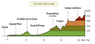
    The plains are irregular, with solid and intercepted valleys and cordons, or barriers, of transverse (crosswise) hills that unite the Andean Mountain system with the coastal plains, which lies to the east of the Cordillera de la Costa, a massif or mountain range, with heights of 1968 to 3,281 feet. The intermediate depression between the coastal range and the Andes is a discontinuous land organized in a series of basins called Pampas are about 35 miles wide and extend to the south of the Copiapó River (200-miles north of La Serena), to the Elqui River, which is east of La Serena. East of this line are the Cordillera de Los Andes and the Nevada Ojos del Salado, which at 22,572-feet, the world;s tallest active volcano are both high and impassable.
    There are four main geomorphic units along the Chilean coast in this area:
1. El Marco Montañoso (The Mountainous framework) Cordillera de Nahuelbuta
2. Las Terrazas Marinas, the sea terraces (between the coastal zone and Cordillera)
3. La Planicie Litoral (Zona Costera, or the coastal zone)
4. La Planicie Ribereña, the Riparian plain, by or on the banks of a rive (Bio River Hydrographic basin)
A cross-section of the landform where Lehi landed, far south of the Atacama Desert. However, all along the Chilean coast from south of Valparaiso to Arica, there is a Coastal Plain that is and always has been hospitable. In the area of La Serena, this coastal area has a Mediterranean Climate that is much like Southern California, the tip of South Africa, and the Mediterranean Sea

Geomorphology is the science that studies the forms of the Earth's crust, focused on describing, understanding its genesis and understanding its current behavior. The geoforms of the Chilean territory are multiple and varied. The characteristic morphology of Chile's long territory in the South American area is given by three fundamental traits that determine the relief in the longitudinal sense: the Cordillera de los Andes, to the east; The Cordillera de la Costa, to the west; And the intermediate depression, between both mountainous systems. As lower relief units, the mountain and the coastal plains can be added.
    As a low-relief bench, similar to a giant uplifted terrace along the coastal cliff of northern Chile, a line of low coastal mountains, the Cordillera de la Costa, lies to the west of the Atacama Desert, and to its east rises the Cordillera Domeyko, foothills of the Andes. The desert consists mainly of salt pans at the foot of the coastal mountains on the west and of alluvial fans of sloping from the Andean foothills to the east; some of the fans are covered with dunes, but extensive pebble accumulations are more common.
    Cordillera de la Costa corresponds to an extensive mountain range that stretches along the coastline of northern Chile. Its width is between 9 and 31 miles and reaches an average altitude of 5,250 feet. In general, the altitude of the Cordillera de la Costa increases from north to south and reaches the highest elevations, approximately 9,186 feet above sea level, at the latitude of Paposo. In some parts, this mountain range rises abruptly from sea level, forming a cliff that can reach up to 3,281 feet above sea level.  The small springs located along the northern coast of Chile in the vicinity of Antofagast are the visible discharge of a regional groundwater body in the very low permeability Cordillera de la Costa, whose hydraulic conductivity decreases downward and flow is dominantly though fissures and storage in the low porosity (low porous) rock matrix. It is believed that about 1000 BC and earlier, the rainfall along this coast was much higher than that found today.
    The Atacama is sparsely populated, with most towns located along the Pacific coast. In interior areas, oases and some valleys have been populated for millennia and were the location of the most advanced pre-Columbian societies found in Chile.
    As can be seen from all of this, the claimed landing site of Lehi at Coquimbo Bay and La Serena, lies between 300 and 500 miles to the south of the Atacama Desert which Hender claims would have precluded such a landing. In fact, as we have often enumerated here, the area of La Serena, though somewhat arid, is a Mediterranean Climate and not a desert at all.
    His further comment: “NASA has used it to test its NOMAD moon and planet exploration vehicle, as the land surface of the Atacama Desert is more like the surface of Mars than it is of any living surface here on earth. The Atacama is not a 'living desert.' It is a dead, dry land for hundreds of miles and shows no signs of any such thing as previously being forested or having had abundant animal life.”
Left: Map showing relationship between the Atacama Desert, the Altiplano, and narrow coastal strip and the mountains; Right: Map showing many of the settlements that occurred and, in most cases, still exist along the Chilean coastal strip. In addition, there were also numerous settlements within the Atacama dating back into BC times

Actually, there is no disagreement with Hender’s description of the Atacama; however, his placement of it being Lehi’s landing site is totally inaccurate. At the same time, while we are not suggesting Nephi, or any of those who went north after Lehi died at Le Serena, ever set foot in the Atacama, it should not be considered uninhabitable, since as the map above shows, numerous settlements along the Chilean coastal strip has occurred since BC times.
(See the next post, “Is the Chilean Landing Site Really a Myth? Part II,” for more regarding Dan R. Hender’s article on his website about the Chilean landing of Lehi is just a myth)

Wednesday, November 28, 2018

The Importance of Understanding Personal Revelation-Part II

Continued from the previous post regarding the receiving of personal revelation and personal answers to prayer, inquiries and concerns during the era of the dedication of the Kirtland Temple, as numerous people reported in journals, talks, and articles. Therefore, it should be no surprise or even a questionable event that Frederick G. Williams, a member of the First Presidency at the time, would have received such a personal revelation as he stated.
In describing Frederick G. Williams character, responsibilities, and ties to the prophet, besides being a counselor in the First Presidency, it should be noted tht for many years he was Joseph Smith’s closest friend of whom the prophet said: “He was respected by the entire community, his name was a tower of strength, and his counsel was sought for, respected and esteemed” (Joseph Smith and Heman C. Smith, History of the Church, Vol.1, Reorganized Church, Lamoni, Iowa, 1908, p142; Times and Seasons, vol.4, pp172, 177-178).
    Joseph also wrote of him, “Bro. Frederick G. Williams is one of those men in whom I place the greatest confidence and trust, for I have found him ever full of love and brotherly kindness. He is not a man of many words, but is ever winning, because of his constant mind. He shall ever have place in my heart, and is ever entitled to my confidence. He is perfectly honest and upright, and seeks with all his heart to magnify his presidency in the church of Christ, but fails in many instances, in consequence of a want of confidence in himself. God grant that he may overcome all evil” (Journal of History, vol.4, 1911, p3). In fact, the 1832 narrative of Joseph Smith History Account contains the earliest known account of Joseph’s First Vision and the only account in his own handwriting; half of this historical event was in the handwriting of his trusted secretary, Frederick G. Williams.
During this time Kirtland was located 20 miles northeast of Cleveland, the latter at the time was a single house; Missionaries taught in Kirtland, Mentor, Orange, Thompson and Amherst townships; Saints from Coalsville Branch settled in Thompson; Joseph and Emma moved into the Johnson home in Hiram; General Conference was held in Orange 
    Elder Williams, who took an active interest in the building of the Kirtland Temple, and at one time in June 1835, subscribed five hundred dollars to this fund, said he received a personal revelation from the angel sitting beside him. In addition to his experience in having the angel sit down beside him during the prayer of the temple, Elder Williams wrote down on a piece of paper from his pocket what was told him. He did not broadcast that, tell anyone else in a speech or make a big issue over it. He kept that note stashed away in his personal papers and it was not found until long after his death. He did tell his immediate family, who reiterated it after his death. His son, Ezra G. Williams stated on April 11, 1864, regarding the note Frederick G. Williams made of this event, “This paper is in the hand writing of my father, Fredrick G. Williams. The characters thereon I believe to be a representation of those shown to him at the dedication of the Kirtland Temple.”
    A thoughtful person, especially one who has himself or herself received such answers, can readily understand how this came about. Elder Williams was a member of the First Presidency and counselor to the prophet Joseph Smith, and one would assume, in good standing with the Lord. He had been a navigator and a pilot in ships on Lake Erie for some time earlier than this event, and at the age of 26, because his expertise on the lake was well known, was hired by 28-year-old Captain Oliver Hazard Perry during the War of 1812 to navigate and pilot his command ship on the lake during engagements with the British.
Frederick G. Williams was an accomplished ship’s pilot and navigator and piloted Captain Oliver Hazard Perry’s ship on Lake Erie during the War of 1812

Thus, it would be most likely, as the thought occurred to Elder Williams about Lehi’s landing, where that might have been. As a former navigator, he was likely curious as to where and how that was achieved. He would not have been particularly knowledgeable as few Americans were at this time, of South America, its coastline, or any likely landing sites since such information was simply unknown in the U.S. at the time—especially to a backwoods country doctor.
    The fact that the Lord had compassion on Elder Williams and provided him with an answer to his question seems self-evident based on the man’s own testimony of it which he shared with his family. That a later descendant, Frederick G. Williams III, working with John W. Welch and John L. Sorenson in the FARMS group, claims his ancestor’s note was not a revelation and was not even representative of his thinking at the time, should carry little weight.
    What this descendant might have actually known and not just assumed because of his belief in Mesoamerica, is not stated, but Mesoamericanists have repeatedly made reference to this rebuttal and dismissed Elder Williams as having known anything about the matter beyond his own opinion. However, no other member of the Williams family to-date has made such a comment or even a reference. And the fact that Elder Williams was one of the most influential members of the community, and of the early Church, should also be understood, as the fact he was not only in the original fully organized First Presidency with Joseph Smith, but was also a close, personal friend and private doctor of the prophet. In fact, Joseph and Emma named one of their sons Frederick Granger Williams Smith, after their close friend. Elder Williams as well as being Joseph Smith’s recorder, personal secretary and confidant, was also the private physician of almost all of the early Church leaders, and the principal doctor for the Saints in Ohio, Missouri, and Illinois until his death in 1842. It might also be of interest to know that Elder Williams was one of the twelve chosen to assist the Colesville Branch to lay the first log, for a house as the foundation for Zion in Kaw Township, twelve miles west of Independence—the log was carried and placed by the twelve men in honor of the twelve tribes of Israel.
    In addition, as we have stated elsewhere in this blog, Elder Williams was called by direct revelation from the Lord to be a missionary on the original mission to the Lamanites, was later appointed clerk and scribe to the prophet in 1832, and was Assistant President and counselor in First Presidency again as the direct result of a revelation. He consecrated and gave by deed to Joseph Smith 142 prime acres in Kirtland upon which the temple was later built, and participated in the Camp of Israel (later called Zion’s Camp) expedition to Missouri, during which time he served as General, camp doctor, and paymaster until the men were discharged.
He was the editor of the early newspaper printed by the Church, called the Northern Times, and member of the publications committee that printed the Doctrine and Covenants, as well as Emma Smith’s A Collection of Sacred Hymns, for the Church. In addition, Elder Williams helped organize and was a trustee of the School of the Prophets, was elected Justice of the Peace in Kirtland, and appointed an officer in the Kirtland Safety Society before moving to Far West, Missouri in late 1837.
    From all of this, one might surely state that Elder Williams was not only a member in good standing, but a valuable and spiritual member of the Church, certainly worthy of receiving personal revelation—something that, by definition, is “personal” and not provided for anyone else. Though there has been a lot written and debated over the note Elder Williams wrote on the sheet of paper, specifically that it was not a revelation, seems of little consequence. What is important is that the location given, at a time when nothing could have been known about that coastal area of South America in the 1830s where Williams and the Church were located, has turned out to be extremely consistent with Nephi’s many descriptions of it as found in 1 Nephi 18:23-25).
    In fact, Elder Williams’ stated location of that landing site was not only right on, and matched every description left us in the scriptural record, but had to have been received as he stated, or the luckiest guess known to history. It would have been like someone, before man was sent to the moon, for someone to predict the back face of the moon that had never at the time been seen by man. Some insist it was not a revelation to the Church, and Elder Williams never claimed it was, but the information certainly had to have been inspiration since nobody could have known the accuracy of such an obscure location in the 1830s.
    It is interesting that this event has elicited so much rebuke from Land of Promise theorists who have felt threatened by Elder Williams' note, which, once it surfaced sometime after his death, was originally thought by some as being a revelation received from Joseph Smith which Williams, as the prophet's scribe and recorder, wrote down. However, it was never claimed by Williams to be such, only a personal revelation to himself, which is exactly how he treated it. 
    The thing that should be kept in mind is that while all the negative comments about this note stems from it being about Joseph Smith and a revelation of the events of Lehi's course and landing, and to which all the discrediting remarks are directed, none seem to recognize the importance of the information it contained. The fact, as we have written about many times in this blog, is that the location is unerringly consistent with the scriptural record of Nephi and to their landing site, and is remarkably consistent with topography, terrain, landing capability, as well as what existed and was found there--describing a place that no one in the 1830s in the location of the early Church could have possibly known or even heard about. No such information was available to Americans in general, or even to specific people since the area was relatively unknown to all in North America during Williams lifetime. Rather than fight against the information disclosed by Elder Williams' note, one might want to look into the information to see how perfectly the location fits Nephi's description as recorded in 1 Nephi 18:23-25.
    In light of this, it would appear not only Elder Williams' worthiness to receive such personal knowledge, but that his actions and testimony are accurately portrayed under the circumstances and quite believable.

Tuesday, November 27, 2018

The Importance of Understanding Personal Revelation-Part I

We should keep in mind that “personal revelation” is available to all members of the Church (as well as others on occasion). As it states in D&C 43:25, “The Lord reveals His will through dreams and visions, visitations, through angels, through His own voice, and through the voice of His servants.” We can add to that D&C 1:38: “Whether by mine own voice or by the voice of my servants, it is the same.” Add to this that “The Lord’s house is a house of order, and the Prophet Joseph Smith taught that “it is contrary to the economy of God for any member of the Church, or anyone [else], to receive instruction for those in authority, higher than themselves” (Teachings of the Prophet Joseph Smith, p21). 
    As Boyd K. Packer said, “You may receive revelation individually, as a parent for your family, or for those for whom you are responsible as a leader or teacher, having been properly called and set apart.” Each of us is endowed with the Spirit of Truth. As the Apostle John stated: “Even the Spirit of truth; whom the world cannot receive, because it seeth him not, neither knoweth him: but ye know him; for he dwelleth with you, and shall be in you” (John 14:16-17).
    In addition, we may receive answers to prayer, to contemplation, to direct or indirect inquiries—but these are “personal,” that is, they are not for anyone else. Few people who have received personal revelation discuss them with anyone else, other than perhaps a spouse or family member, or very close confidant. As the Lord said, “Give not that which is holy unto the dogs, neither cast ye your pearls before swine, lest they trample them under their feet, and turn again and rend you” (Matthew 7:6). That is, “personal revelation” is just that—it is personal.
    One of the problems of this is that we tend to ignore “personal revelation” people receive when we become privy to the fact since it is something not broadcast from the highest pinnacle and received “from on high.”
Regarding this and the following information, we have written before about Frederick G. Williams and his claim and testimony, it is interesting that despite the information previously given, and even some of the discussion among readers here, the very interesting and enlightening story of Elder Williams has been mostly ignored by many, especially the theorists, and even vilified by the latter at times because his information cast direct doubt on their Land of Promise models and locations.
    At the seven-hour long Kirtland Temple dedication on March 27, 1836, where a thousand persons attended, and at which time the Hosanna Shout and singing of W.W. Phelp’s hymn “The Spirit of God Like a Fire is Burning” were initiated, a noteworthy event occurred. After a two-and-a-half-hour sermon given by Sidney Rigdon, Joseph Smith offered a dedicatory prayer that he said was given to him by revelation (History of the Church, Vol.2, p420). 26-year old Truman Osborn Angell, who had worked on building the temple, and who would become one of the original pioneers of Utah, one of Brigham Young’s brothers-in-law, a Church Patriarch, and who held for many years the position of Church Architect, designing the Salt Lake Temple, the Lion House, the Beehive House, the Fillmore Statehouse, the St. George Temple, and many other important public buildings, of which his modifications to the Salt Lake Tabernacle are credited with creating the perfect acoustics for which the building is famous, stated a personal experience at the time of this dedication:
    “When about midway through the prayer, there was a glorious sensation passed through [the Temple]; and we, having our heads bowed in prayer, felt a sensation very elevating to the soul. At the close of the prayer, F. G. Williams being in the upper east stand—Joseph being in the speaking stand next below—rose and testified that midway during the prayer an holy angel came and seated himself in the stand. When the afternoon meeting assembled, Joseph, feeling very much elated, arose the first thing and said the personage who had appeared in the morning was the Angel Peter come to accept the dedication” (The Journal of Truman Osborn Angell, in Sarah Jane Angell Tolman, Autobiography “His Journal,” Our Pioneer Heritage, Vol.10, 1967, pp195-213).
The main lower assembly room of the Temple. Yellow Arrow: Where Frederick G. Williams was sitting at the dedication

President Frederick G. Williams testified that he saw a "holy angel" enter the temple during the opening prayer and sit between himself and Joseph Smith, Sr. In addition, nine witnesses wrote about the event, and even though details in their records conflict, they all saw the manifestation and believed it was the Savior as they recorded the event, some even describing the appearance. In fact, according to George Albert Smith, “On the first day of the dedication President Frederick G. Williams one of the Counselors of the prophet  and who occupied the upper pulpit bore testimony that the Savior dressed in his vesture without seam came into the stand and accepted of the dedication of the house; that he saw him and he gave a description of his clothing and all things pertaining to it” (George A. Smith, Journal Of Discourses, vol.11, p 10). 
    Even the prophet Joseph Smith acknowledged this event, writing: “President Frederick G. Williams arose and testified that while President Rigdon was making his first prayer, an angel entered the window and took his seat between Father Smith and himself, and remained there during the prayer” (DHC, vol.II, p427).
    It might be noted that this is also the temple where a week later Christ appeared to accept the temple offering, and subsequently Moses, Elias and Elijah appeared to restore keys, power and authority to Joseph Smith and Oliver Cowdery. In fact, months before and months after its initial dedication the Kirtland Temple was the site of many divine manifestations. In fact, "more Latter-day Saints beheld visions and witnessed other unusual spiritual manifestations than during any other era in the history of the Church,” and angels in at least ten different meetings leading up to the dedication were reported (Church History in the Fulness of Times Student Manual, ch 13, “Glorious Days in Kirtland 1834-36,” 2003, pp53-168).
In fact, Orson Pratt recorded of this event and time: “God was there [in the Kirtland Temple], his angels were there, the Holy Ghost was in the midst of the people…and they were filled from the crown of their heads to the soles of their feet with the power and inspiration of the Holy Ghost, and uttered forth prophecies in the midst of that congregation, which have been fulfilling from that day to the present time" (Deseret News, Jan. 12, 1876, 788). Eliza R. Snow, added of this dedication: “The ceremonies of that dedication may be rehearsed, but no mortal language can describe the heavenly manifestations of that memorable day. Angels appeared to some, while a sense of divine presence was realized by all present, and each heart was filled with "joy inexpressible and full of glory" (In Edward W. Tullidge, The Women of Mormondom, 1877, p95.)
    It is certainly noteworthy to consider all of these events, showing that the angel sitting next to Elder Williams in the temple was not unusual for this particular day and time, nor would receiving a personal revelation out of the order since both members and leaders had numerous spiritual experiences at this time.
    Elder Williams played an important role during the days of the restoration, in organization of the Church, and in the establishment of the kingdom. It might be of interest to know that Truman Osborn Angell also relates a story told him by Frederick G. Williams, when the First Presidency came to observe the near finished temple. As Elder Williams told Angell: “Joseph received the word of the Lord for him to take his two counselors, myself and Sidney Rigdon, and come before the Lord and He would show us the plan or model of the house to be built. We went upon our knees, called on the Lord, and the temple building appeared within viewing distance. I being the first to discover it, then all of us viewed it together. After we had taken a good look at the exterior, the building seemed to come right over us, and the makeup of this hall today seems to coincide with what I there saw to a minutia."
(See the next post, “The Importance of Understanding Personal Revelation-Part II,” for additional information surrounding the dedication of the Kirtland Temple, and the experience of Frederick G. Williams in which he claimed a “personal revelation.”

Monday, November 26, 2018

Fortress Guarding Cuzco or the City of Nephi – Part IV

Continued from the previous post, regarding the temples in the Cuzco area and their antiquitous origin and purpose and the guarded entrance into Cuzco and the likelihood Nephi set up some early warning site south of the city of Nephi.
The ruins of Tipón on the mountain plateau overlooking the ancient road into Cuzco

Since Tipón was well known during Inca times and often claimed to have been built by uninformed historians and tourist groups to encourage tourism, it should be understood that this site dates back 4,000 years, well into BC times, and its defensive nature would have served little purpose to the Inca who controlled this area in their time for hundreds of miles around. In fact, the most impressive feature of the entire Tipón complex is “the massive four-mile long muralla or outer wall that encircled the site. The wall is about 3 miles long; ranges up to heights just over 26 feet, and is 6½ feet thick at the top, and between 13 and 19½ feet wide at the bottom, with the cliff on the outside falling off steeply to the valley below.
    Obviously, a structure built for the defense of its occupants and the surrounding area.
    It should also be noted that its closeness to a natural spring and the adjacent Pukara River, would have been an attraction for necessary irrigation construction of stone-lined canals, gravity-flow vertical drains or drops, and spring water collection headworks for agriculture watering and consumption in the earliest period of Peruvian occupation of this area.
   In addition, according to Dr. Alfredo Valencia Zegarra, et al., of the Wright Paleohydrological Institute, Denver, in a 2001 study, there is no question that the walls and irrigation channels were in existence during the Wari period before 1000 AD, several hundred years before the Inca.
    Today, because of its magnificent irrigation canals that could deliver almost 1,600 gallons per minute to the living and agricultural facilities below, and also channels, including a long canal from the north, and the three canal systems, each serving specific functions, is considered a water management masterpiece because of its combined development and use of both surface and ground water within a walled enclosure of nearly 500 acres containing exceptional stonework of cut and dressed basalt and andesite stone blocks and a complete agriculturally oriented enclave just over a dozen miles from Cuzco.
Both Wanakawri and Intiwatana were mountain top fortresses that overlooked the ancient road into Cuzco. Dotted arrows show their attack lines to the narrow valley through which an enemy could approach Cuzco

Intiwatana, meaning a “place where the sun (Son, or God) is tied,” which overlooks the ancient road from its perch high atop the main hill above Tipón, was not only an effective lookout, or outpost, but also was where astronomical observations could be made, critically important to the planting and harvesting of the many fields below.
    It is interesting that the stonework of Intiwatana is extremely similar and even identical to several other sites around Peru, suggesting the same people with the same technology of the time built all these sites that are so similar in design, construction, and skill.
    In addition, the special water handling at Intiwatana involves a main canal that enters and leaves the site after passing underground through it and making a water supply available to the those who lived there. The ancient Peruvians incorporated the canal into the foundations of the buildings while maintaining proper grade and suitable alignment.
    It might be of interest to know that these ancient and earliest Peruvians understood what is called today hydraulic engineering. In fact, their skills and technical knowledge in their use of the supercritical flow phenomenon with its attendant downstream hydraulic jumps that could easily have caused erosion, stone displacement, and over-topping of canal banks. The main canal, as well as the groundwater distribution canal network, has many examples of supercritical flow that were both well designed and adequately managed.
    It is certain that this Tipón complex, along with its various sites, was a completely self-contained community. For a defensive outpost, or resort, this self-containment would have been critical.
Left: The Intiwatana ruins atop Tipón were marked by high walls and excellent stone work; Right Top Left: Ancient stonework at Intiwatana and the similar stonework (LtoR) Huánuco, Ingapirca (Bottom LtoR) Pisac, Ollantaytambo, Machu Picchu

As mentioned elsewhere in these recent posts, Intiwatana was built atop a peak overlooking the Tipón complex and held an important and significant position in this large outpost leading into the Cuzco Valley, and was a self-sustaining location with it own storage facilities for food, supplies and weapons, and with its own astronomical sttings to determine planting, harvesting and other agricultural needs, as well as having large populace placement and troop barracks.
    To the north side and 2,000-feet above Tipón, is the ancient site of Cruzmoqo on the summit of 13,000-foot Wayrapunku, technically one of the sectors of the Archaeological Park, located at the north boundary, and is considered to have been an important checkpoint and ancient outlook station, though all that remains of the structures are the surrounding defensive outer walls. This outlook or outpost sits on a prominent natural rocky outcrop high in the hillside above Tipon and is accessed from below by a route to the east, away from and out of view of the ancient road below.
The defensive outer walls of Cruzmoqo to the north and east of the Tipón complex again shows the defensive nature of these early occupants long before the Inca

These defensive walls of Cruzmoqo, the highest site of the entire complex, are extensive on the north and west of the ruins along the crest of the hill. Cruzmoqo is also called Qosqo Qhawarina or Mirador del Cuzco (“Viewpoint of Cuzco”), since the early occupants of this outpost could see all the way to Cuzco from this site. In addition, there are petroglyphs decorating the rocks around Cruzmoqo that date well into BC times, as does the excellent andesite stonework, and veneer that was cut and carefully carved to cover the rough fieldstone of walls. There is also a unique polished, carved-out basin whose purpose has not been determined. There seems little question among archaeologists that Crumoqo served a defensive and signal function.
    Canals lead all through the Tipón complex, from each terrace, a 115 foot by 75½ foot rectangular Plaza, stone structures, and lower levels, with branches leading to other areas within the site. Where the crops were grown was highly protected, and there seems no doubt this was intentional, with the multiple terraces stretching 100-feet down a slope, ending at a steep cliff, with the other approaches surrounded by the high outer wall. The terraces themselves were under the constant view of a Qolpa containing doorways, windows, and niches providing a scenic view of the growing crops, situated along the northwest hill route to Intiwatana above.
The Pisac hilltop fortress 

East and a little north, beyond Intiwatana, on the backside of these mountains, is the site of Pisac (Pisaq), another mountaintop fortress overlooking the entrance to the sacred Valley that runs north and parallel to the Cuzco Valley. It is clear that these earliest Peruvians considered the importance of guarding the two entrances to the north along this ancient roadway route.
    Below this mountains area of craggy sandstone outcrops, Andean grass, brown scrub and small bushes where the valley narrows to a canyon along the ancient roadway route into Cuco, through which the Huatanay River plunges, and at the foot of the hills upon which Tipón is built, are today’s settlements of Huasao, at 10,270 feet elevation—once a wetland, swampy area, it is now the home of numerous brujos and Shaman, the latter having practiced their trade in the lagoons of Huancabamba or Lambayeque, and who are some of the most powerful teachers dating to ancient times in the area.
    Adjacent to Huasao is the village of Saylla, an ancient settlement 17½ square miles in size, that blocks the way northward into Cuzco—all traffic anciently (as well as today) went through this area and it was a stop-over for lengthy travel between towns to the south and the valley to the north. It is the ancient ayllu of Saylla Anahuarque, which has an important complex of ruins 5 miles from the contemporary town called Silkicanchi. Beyond Saylla to the south is Choquepata and Oropesa.
    Above Huasao is Patabamba (not to be mistaken with the settlement of the same name due west of Cuzco and northwest of Cusibamba), a small agricultural settlement called “the balcony of the Sacred Valley” containing numerous ancient ruins where the ancient tradition of the jakira technique of weaving thick cloth and lliklla blankets in Tanka Ch’uru designs were practiced, and sitting below mountain lakes where herds of llama and alpaca have always grazed.
    As was stated initially, Nephi taught his people to build buildings, that he knew the hatred of the Lamanites toward he and his people, and that he fought want battles or wars with the Lamanites in the defense of his people, and that by the end of 200 years from Nephi’s first settlement, the Nephites had spread throughout the land. As the Lamanites became more and more belligerent toward the Nephites, it seems prudent that Nephi would have built more buildings around the ity of Nephi within the Land of Nephi, that, according to Jarom, the Lamanites “came many times against” them and the Nephites “began to fortify their cities or whatsoever place of their inheritance” (Jarom 1:7).
    Assuming the Valley and city of Cuzco was where Nephi settled, then these various fortifications around the area guarding the entrances into the valley seem very likely to have been early Nephite settlements and were, indeed, built to guard the city of Nephi as early warning sites against Lamanite attack.

Sunday, November 25, 2018

Fortress Guarding Cuzco or the City of Nephi – Part III

Continued from the previous post, regarding the temples in the Cuzco area and their antiquitous origin and purpose and the guarded entrance into Cuzco and the likelihood Nephi set up some early warning site south of the city of Nephi.
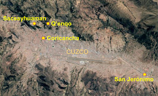
The temple locations in Sacsayhaman and within Cuzco at the Coricancha; Q’enqo and San Jerónimo are also shown

As previously mentioned, there was an ancient temple built in the valley below  Sacsayhuaman and Q’enqo in the center of Cuzco, now called the Corincancha. This temple, obviously served as a place of worship, while the one on the hill next to the fortress of Sacsayhuaman was just as obviously connected to a defensive resort (Mosiah 11:13). Much later in time, the Inka considered the temple in the valley as the “Golden Enclosure,” and the most sacred of all Inca sites and considered the very center of their world.
    Both temples in Cuzco were built with exemplary masonry skills, the massive walls of the complex shaped into large Andesite stone blocks perfectly cut and fitted together without mortar. The interior buildings were one story and had thatched roofs interwoven with gold “straws” that glittered in the sunlight, with the doors of the buildings covered in gold and silver sheets, as were the interiors and exteriors of the various temples, and the inner side of the perimeter wall that chronicler Garcilaso de la Vega claims were studded with emeralds.
    In fact, the temple to Inti, also called the Temple of the Sun (or more likely, the Temple of the Son), had a large gold statue encrusted with jewels, and the walls were lined with 700, 4½-pound sheets of beaten gold, while a nearby building was similarly lined with silver. The temple courtyard and grounds, called the "Golden Garden" contained life-size gold replicas of the animals and plants of the kingdom. Much later, this entire area was inhabited by the Inca starting about 1400 AD until 1534 AD when they were conquered by Pizarro and Spanish conquistadors.
The mountain plateau complex of Tipón, with Qolcas, and Sinkunascancha, and Intiwatana on a peak overlooking Tipón and the valley through which the ancient road ran the last few miles into the Huatana River Valley and Cuzco

In the South Valley of Cuzco, close enough for an early warning outpost to have been established, is today called Tipón, an ancient settlement 13½ miles south of the city of Cuzco in the prominent Pachatusan (Pacha Tuan, Quechua meaning ”one that sustains or props up the earth”) mountain, whose height is 15,885 feet and overlooks the Sacred Valley, with the site located between two streams and above the Urubamba River.
    While this perch has a commanding view in all directions, archaeologists readily admit today “that the true purpose of Tipón is not known, and even the original name of the site is lost.” What is known is that the ancient settlement was built with high retaining or defensive walls, thirteen terraced fields for the growing of many crops, and an irrigation system that was both ingenious and would have proven vital to a defensive compound.
    There are three distinct areas besides the site itself, one is called Qolcas, considered to be a storage facility for both food harvested in these terraced fields and for equipment, supplies and weapons for the occupants of this site; another area is Sinkunascancha, which evidently served as a barracks for either military troops, or a large concentrated population.
The Qolcas ruins, sitting above Tipón and overlooking the terraces, to the left or west on the plateau, is Sinkunascancha, and behind and above to the northwest of Qolcas is the Intiwatana outpost

The third area of Tipón is that of Intiwatana overlooking it all, from its 12,992-foot perch atop the mountain peak, called Cerro Cruzmoqo, above Tipón, which sits at 10,990 feet. The qolcas, colcas, or qollqas, were buildings or spaces built for the storage of goods, and were typically found at early Peruvian settlements, towns and villages.
    The name Cosqo Qhawarina, which means “from where Cuzco can be seen,” suggests that there was a line-of-site through the valley where a signal device could have been used—such as mirrors on sunlight or some type of smoke sign or signal.
Mt. Pachatusan and the Intwatana above Tipón shows a direct line-of-site into the Cuzco Valley, as well as perfect observation to the south of any approach up the narrow valley

The construction and habitation of these Qolcas were one of the central points of early Peruvian building long before the time of the Ina, and allowed each settlement to be independent and have sufficient food on hand, as well as clothing and supplies for artisanal production or war, and to supply the deficiencies that could be derived from natural or social events that affected the food balance.
    In this area a handful of miles south of Cuzco is the mountain top fortress, today named Intiwatana (Inti Watana, meaning “connected to God,” or “where God is”), on the northeast side of the road, while the Wanakawri fortress sits back from the road on the southwest side. Intiwatana is actually part of the overall Tipón Complex, which was discussed in the previous set of articles about the early settlements along this road. While Tipón, an ancient multi-terraced site of canals, platforms, plazas, aqueduct, and fountains that transformed a mountainside into a true engineering marvel, according to the American Society of Civil Engineers, sits at 10,990 feet, covering 590 acres, and called “the most beautiful place in Peru.”
    This most sacred site of the entire complex, Intiwatana sits atop a small hill at a higher elevation, overlooking Tipon, Qolcas and Sinkunascancha. The structure has numerous rooms with trapezoidal niches from where one can see everything below. The entire site is built with megalithic blocks of stone, with beautiful fountains and small channels where water continues flowing to this day. In fact, there re mysterious and secret underground channels that can now be seen
    And an ovoid or egg-shaped tower located at the front of Tipón provides an excellent view to the south where all the gorge can be seen.
Tipon’s terraces took advantage of all available land for seeding, even to the extent of placed stairs from one level to the next in positions to not take up any available land for planting

An interesting part of Tipón, as well as numerous other ancient Peruvian terraced sites, is the conservative use of land for planting. These terraced walls almost always included zurnas, or overhanging steps that appear on the terraces' walls and that were like enormous lithic cloves distributed as stairs, and were built in order to avoid taking planting space with the stairways. This archeological site belongs to the Inca period where an irrigation system can be seen with extraordinary vertical and horizontal channels on overlapped terraces. Water flows from underground to a fountain that distributes water through those channels. It was an important agricultural center.
    While elsewhere these ancient terraces followed the general shape of the land up hillsides and mountain slopes, Tipón’s terraces are precise and right angled, a deliberate deviation that creates a unique, captivating aura, and were obviously built to channel natural resources right into the fields and crops. In fact, every verdant valley has been terraced and planted to take advantage of available crop growing land. Often settlements were placed on the slopes and hillsides to conserve valley land for planting. Depending on where these settlements were located, many were actual fortresses, for their own protection, and some served the purpose of warning outposts with excellent views of approaches over which they guarded, typically from the south.
    Since archaeologists talk about this complex as being an important shrine and an agricultural center, because of the irrigation involved, but offer no firm conclusions about the overall purpose of the site, others have suggested the obvious. As stated by CuzcoPeru, “It is possible that Tipón was occupied by people that fought wars during many years and to ensure their protection, they built colossal and vast defensive walls that surely took many years of work. Of course later, the walls were useless when the Inca conquered all the regional kingdoms who then became part of Tahuantinsuyo great empire. Nor were they helpful against the Spanish with their firepower.”
(See the next post, “Fortress Guarding Cuzco or the City of Nephi – Part II,” for additional information on the outpost that guarded the entrance into Cuzco, or the city of Nephi)

Saturday, November 24, 2018

Fortress Guarding Cuzco or the City of Nephi – Part II

Continued from the previous post, regarding the guarded entrance into Cuzco and the likelihood Nephi set up some early warning site south of the city of Nephi.
    The only way into Cuzco (Qosqo) anciently was along the route the ancient road eventually covered, though at the time of Nephi settling there, the area simply would have been an open, level series of more or less level high plains valleys. The area of Cuzco sits on an ancient glacier lake bed at 11,219 feet, and is surrounded by mountain peaks.
    The three rivers through the Cuzco basin and valley area were canalized very early in Peruvian history by the first occupants, diverting the streams to create the space necessary for a larger settlement, which is believed to have been around since about 500 BC.
    The Cuzco-Sicuani back-arc Basin in the Central Andes is located between Cuzco and Sicuani, a town to the southeast, at the northern end of the Peruvian-Bolivian Altiplano, and at the southwestern side of the Eastern Cordillera. This area is part of the high plateau basins, of which there are three along the Cuzco fault system, which intermountain basins formed from the episode of Andine tectonics, which established the Cuzco-Sicuani back-arc basin.
The lower south end of the Cuzco Valley, or Valle Sur, and the Huatanay Valley, which includes the northern arm up past Pukara

At the west end of the Cuzco basin, and extended valley is the Huatanay valley, a basin that extends 20 miles east to Huambutio, about 3½ miles beyond Oropesa. At the south end and about six miles from the original “old town” or original development of Cuzco, is the settlement of San Jerónimo, whose ruins covering 64-square miles, date back to the last century BC, and later occupied by the Wari, Qotakalle, and K’illke cultures. Within this area of the ancient kingdom of Omas and Maras, composed of the Antis and Maras cultures, and an antiquitous settlement of Omas, were later formed fourteen ayllus, or communities, of Yabacona, Collana, Chahwan, Qosqo, Ccallampata, Urin Saca, Chimaraura, Acamana, Apymayta, Ro’uequirau, Rarau, Orcompugio (Picol Orocompugio), Sucsu Aucaylle, Kirkas, Conchacalla, and Chima Panaca. During Inca times, these ayllus were controlled by members of the Inca royal family who sought to demonstrate their power and prestige, but who were under the control of Cuzco.
    The Spanish after their conquest and assimilation of the Cuzco Valley, eliminated the separate ayllus and built a singular town in the lower reaches of the valley called San Jerónimo (St. Jerome), within the Huatanay river basin, on the original five ayllus areas of Urin Qosqo, Yabacona, Collana, Urin Saca and Chimaraurau. This area still has a very large Quechua-speaking population.
    In the valley itself, the earlier, more elevated and most impressive settlement was toward the north and called Hanan, with the lower part in the south of the valley being referred to as the Hurin. There were originally small groups of buildings organized around a courtyard within a high-walled enclosure, called kanchsa. There were also vast plazas, agricultural fields, canals, and decorative, but purposeful fountains. Outside the walls were the farming and artisan communities that spread out into the valley, where qollqas, or storehouses, were located providing the early settlement with numerous storage capacity for food, clothing, and weapons.
    Several well-paved roads led out from the city into the valley and beyond, which eventually led “from city to city, and from land to land, and from place to place” (3 Nephi 6:8).
Map showing the location within the Cuzco Valley of Sasayhuaman and what is nowcaslled the Coricancha (Qorikancha), which was the original temple built in BC times, which the Spanish found its walls and floor covered with gold before they destroyed it and built a Spanish cathedral on the ruins called the Church of Santo Domingo. The original temple (Coricancha) is located beneath it and still partly visible

Initially, there was a temple built in the basin that is today referred to as the Qorikancha or Coricancha, over which the present Spanish cathedral of Santo Domingo was later constructed. In this original temple, were worshiped the two gods, Viracocha, the creator God, and Inti, the Son. Much later, during Inka times, several wasi gods were added, such as Chaska-Qoylor, Illapa, and Cuichu, each with their statues. Whether this temple was built before or after the one on the hill connected to the cyclopean Sacsayhuaman fortress is unknown; however, the latter was said to be able to house 1,000 warriors, sat 755-feet above Cuzco and guarded the valley. Next to this temple site was the very tall tower king Noah built (Mosiah 11:12).
    Located to the east of Sacsayhuaman and on the hill called Cerro Socorro, north of Cuzco is an area today labeled as a temple caved out of a gigantic naturally-occurring monolith stretched across a hillside, and called Qenqo (K’enko), meaning “zigzag” or “labyrinth” or “maze.” It is so named because of the maze of secret and concealed underground galleries or tunnel passageways connecting natural chambers, as well as man-made caves the small channels carved in the rocks in a zigzag form. What this shrine or structure was originally called or its purpose is unknown to archaeologists today, though many wild and fanciful claims have been made about its ancient use from being a ceremonial center where demonic rituals were conducted, to a royal tomb, to a location where priests bridged the gap between the living and the dead.
    This lithic complex, referred to as Qenqo Grande, is within a semicircular shape of a 181-foot wide amphitheater about—formed by an outer wall with 19 large niches that were the foundation of a great ancient wall, and at the center of the semicircular natural cavity in the rock is a 20-foot high block of stone that rests on a solid rectangular pedestal, now partially destroyed but was once a carved sculpture. There is another structure about four football fields away referred to as Qenqo Chico, or “small labyrinth,” that only adds to the mystery of the overall purpose of this site—most of which was destroyed by the Spanish extirpators of idolatries in their effort to rid the conquered indigenous peoples of their religious iconic symbols and shrines.
Some of the monoliths and stonework of Q’enqo (original images by Leon Petrosyan)

And as long as everyone is speculating about the area, it certainly could be the “place of resort for the children of Nephi at the time they fled out of the land” (Mosiah 11:13), with its small “outpost” appearance and its labyrinth of underground tunnels on this hill overlooking the northern valley where the land of Shilom was evidently located amidst an area of defensive arrangement and perfect observation within the hillside.
    It is also of interest to know that this enormous site contains irrigation or water canals, certainly an indication of the ancients’ predilection of survival for embedded populations since its 11,500-square-feet area could house several people, not to mention the underground tunnels, rooms and drainage channels for rainwater to exit these areas.
    There is also a rocky ledge decorated with a passage that leads to an underground room, a complex of platforms, and rooms with a chamber carved completely into a gigantic rock. In the lower part of the rock structure are carved, the floor, walls, ceiling, tables, cupboards and niches, with additional rooms for service in the perimeter, considered an amazing work of ancient architecture of these early Peruvians. In addition, behind the central stone rises a promontory with steps carved into the rock, leading to the summit and the remains of a room, probably an observation point of some type. In addition, on the live rock, paved and polished protrude two cylinders of short height considered to be an Intihuatana, which translates as “place where it is moored to the sun,” that is, a formation that calculates the position of the sun.
    It is not known how this device worked, though there are several of these enigmatic carved stones believed to be scattered throughout Peru—the best known being at Machu Picchu—and believed to be a kind of astronomical observatory used to measure time, to establish the seasons, to determine the solstices and equinoxes.
    This overall site is located at the foot of the path that goes from Sacsayhuaman to Pisac—in other words, Qenqo is within a short distance of the safety of the overall fortress at the top of the plateau overlooking the valley. This might suggest, as long as we are speculating here, that the resort was built first, then the large fortress complex added later for greater security and defense. Nearby Qenqo Chico, which was mostly destroyed by the Spanish, shows remnants of high walls, circular planning and the same care in working with the rock—a use of stone and the careful carving that stand out in the ancient Peruvian work.
(See the next post, “Fortress Guarding Cuzco or the City of Nephi – Part II,” for additional information on the outpost that guarded the entrance into Cuzco, or the city of Nephi)

Friday, November 23, 2018

Fortress Guarding Cuzco or the City of Nephi – Part I

Once established in what became known as the Land of Nephi, and while building the city of Nephi, this erstwhile prophet tells us that there were difficulties with his brothers, Laman and Lemuel and the sons of Ishmael, who “were now called Lamanites” and that he made preparations for the defense of the Nephites. “And I, Nephi, did take the sword of Laban, and after the manner of it did make many swords, lest by any means the people who were now called Lamanites should come upon us and destroy us; for I knew their hatred towards me and my children and those who were called my people” (2 Nephi 5:14).
He then tells us that he taught his “people to build buildings, and to work in all manner of wood, and of iron, and of copper, and of brass, and of steel, and of gold, and of silver, and of precious ores, which were in great abundance” (2 Nephi 5:15). He also caused his “people to be industrious, and to labor with their hands” (2 Nephi 5:17). This is also the time that the Lord cursed “a sore cursing, because of their iniquity” to come upon the Lamanites, and “because of their cursing which was upon them they did become an idle people, full of mischief and subtlety, and did seek in the wilderness for beasts of prey” (2 Nephi 5:24).
    Of Nephi’s efforts to defend his people, his brother Jacob wrote: “he having been a great protector for them, having wielded the sword of Laban in their defense, and having labored in all his days for their welfare” (Jacob 1:10), shows that the Lamanites, during Nephi’s time, were battling and attacking the Nephites. Jacob’s son, wrote of the Lamanites: “their hatred was fixed, and they were led by their evil nature that they became wild, and ferocious, and a bloodthirsty people, full of idolatry and filthiness; feeding upon beasts of prey; dwelling in tents, and wandering about in the wilderness with a short skin girdle about their loins and their heads shaven; and their skill was in the bow, and in the cimeter, and the ax. And many of them did eat nothing save it was raw meat; and they were continually seeking to destroy us” (Enos 1:20). We also learn from Jacob’s son, that he “saw wars between the Nephites and Lamanites in the course of my days” (Enos 1:24).
    In the next generation, the Lamanites had deteriorated even further, and “came many times against the Nephites to battle” (Jarom 1:7). Thus, we see that Nephi, when making swords for his people and their defense, had a good idea what was going to happen between his people and those of his brothers. The fact that he made weapons for his people, taught them to build buildings, and labored diligently in their defense, suggests that one of the things Nephi would have done was to build some type of early warning defensive outpost close to and south of their settlement (city of Nephi), yet far enough away to aid them through fast runners to know that the Lamanites were approaching up the narrow valley toward them. This outpost would have been located in an area where the road or route into Cuzco would have been restricted, and any approaching force would have been readily visible.
Map of Cuzco area and the Wanakawri Fortress that guarded the entrance into the Huatanay Valley

Situated at 13,415 feet, and overlooking the ancient road from Titicaca into Cuzco (Qosqo), or the ancient city of Nephi, is the mountain Wanakawri (Guancaure, Huanacaure) and the ancient fortress just below the twin peaks. Located three miles south of the Cuzco, which lies at the west end of the Huatanay valley, a basin which extends 20 miles east to Huambutio. Three rivers cross through the valley, the Huatanay, Huancaro and the Chunchullmayo, all tributaries of the Vilcanota, which runs along the northern rim of the valley.
    This ancient city, which Pizarro and his small band of conquistadors sacked in 1533 AD, held some 200,000 people at the time, part of a kingdom believed to have been 12 million strong. The original city had narrow and frequently stepped streets, often narrow running between buildings constructed out of stones that were cut in irregular shapes and fitted with unbelievable precision without mortar. The following year, Pizarro formally established the municipal of government at Cuzco, but a year after moved the capital to the coastal site of Lima, whereupon Cuzco rapidly dwindled in power and importance.
    La Montaña Wanakauri o Huanacaure, “the Mountain of Wanakauri or Huanacure” is located three miles to the south of Cuzco, and was a small fortress in the mountain guarding the entrance to the two great valleys—Cuzco and Urubamba, the heart of ancient Peruvian center and later Inca empire. The road from Wanakauri joined the main road that is considered one of the greatest engineering feats in the Americas, leading southward out of Cuzco toward Huarcapay and the Lucre District before turning further south toward Andahuaylillas and known today as 3S (Ecuador highway 3 south).
The ancient location of Wanakauri or Huanacaure, a site full of history. It sits at an altitude of 13,386 feet, and is about three miles south of the city of Cuzco, behind the Condoroma, Araja, Huillcaray and Quispiquilla hills and east of Cerro Anawarque. Next to the ancient temple of Qorikancha (Coricancha) in the center of Cuzco, it was the most important shrine in the Cuzco area
 
Wanakauri or Huanacaure, is a Quechua meaning “young man,” or “strong or sharp young man,” and this small site was intriguingly significant in the early period of Cuzco development, since it guarded the area from the south, or from invading forces moving up from the south. When the Inca eventually took over this area in the 15th century, they deified this site and the mountain, making it the last part of the Legend of the Ayar Brothers before entrance into the valley of Cuzco.
The ancient road south of Cuzco, stepped up over the hill, showing the containment walls on each side

However, this road dates many centuries, even millennia before the Inca, and at this point south of Cuzco was a long, straight stretch that led down into the Cuzco Valley, and possibly the best preserved part of the ancient road in existence today. It had walls of containment and retention, was ten feet wide at this point, with paving stones, stairways, and occasional areas where the earth had been cut away and filled with piles of stone, flattened into platforms. The road here was, and still is, an important part of the ancient road system that moved from south of Lake Titicaca northward to Cuzco, and then continued through the central highlands to present-day Quito, Ecuador, and then kept going to what is now Pasto, Colombia, though now it stops at the Ecuadorian border.
    South of there, where the road heads into Cajamarca, it was dauntingly steep, and its seemingly endless stepped terraced-stone expanse was a wide-granite thoroughfare spilling continually down from the Peruvian Andes into the flat valley of Cajamarca—the most important ancient city in north central Peru. This was the route the ancient conquistadors took southward to eventually enter Cuzco—what must have been an astounding experience for these European invaders of the early 16th century. Along this roadway they walked much of the way to Cuzco, since their horses suffered terribly from the sharp edges of the roadway’s stepped inclines. Most of the Spaniards were impoverished farmers from the region of Extremadura, and must have been awed when they rounded the corner, and entered the vast plaza at the heart of an empire, surrounded with monumental palaces and temples, everything glittering with gold leaf and brilliant hanging textiles—commemorating a kingdom more fabulous than Seville and as accomplished as Rome.
The ancient road running along the Vilcanota River through the narrow valley south of Cuzco where it enters the Huatanay Valley. Note the narrow area of approach and how easily it could be observed and defended

Beyond the Cuzco Valley to the south, this road saw thousands upon thousands of pilgrimages, journeys, invasions and military movements that trudged along to the south of the ancient valley, all under the supervision of the Wanacauri fortress outpost that guarded this roadway. Today, the importance of this ancient area is celebrated with feats, fiestas and pageants that honor the ancients who gathered here to worship the sun (or Son) in antiquity, in celebrating the Inti Raymi (Festival of the Sun) and other historically sacred events that had been carried down through time to celebrate this area of extreme importance to those early Peruvians.
(See the next post, “Fortress Guarding Cuzco or the City of Nephi – Part II,” for additional information on the outpost that guarded the entrance into Cuzco, or the city of Nephi)