Tuesday, December 31, 2019

The Death Knell for Mesoamerica – Part I

This article takes a look at John L. Sorenson’s philosophy when he writes: “The Book of Mormon is the authority on the Book of Mormon. Our problem is to discover what it is saying to us.” (Sorenson, The Geography of Book of Mormon Events: A Source Book, FARMS, 1992, p415).
    If Sorenson truly believes in that, then this is the striking of the death knell of the Mesoamerican Land of Promise model. For nowhere in the scriptural record Sorenson wants to use as the criteria of the Land of Promise model does it fit the Mesoamerican model without the changing of the meaning of words, phrases, and descriptions Nephi, Jacob, Mormon and Moroni left us.
    So what does the Book of Mormon itself, and these four ancient prophets, three of which lived their entire adult lives in the Land of Promise say about the location (Nephi), description of the Land of Promise (Jacob), and the fine details, map locations, and other important details of the Land of Promise (Mormon and Moroni).
We can start at the very beginning. The ship Nephi built. First of all, just about every historian agrees from the first 17 chapters of 1 Nephi, that Lehi’s Bountiful was along the south Arabian coast of Oman/Yemen along the Arabian Peninsula, near or within the cove of Salalah, and that they set sail into the Sea of Arabia. So taking it from there, we can easily diagram the voyage of Nephi’s ship by first, understanding Nephi’s description of how it was propelled. As an example, once in the water, Nephi tells us his ship was “driven forth before the wind” (1 Nephi 18:8,9). Now this term has specific meaning naturally as it does nautically:
driven = “urged forward by force,” operated, moved, or controlled; propelled, impel, propel, push, urge forward; carried along by force in a specified direction as in “the wind drives the vessel.” It is a force that pushes something forward, as a sailing ship. Propelled or motivated by something, i.e., the wind, current, engine;
forth = “forward, onward.” Thus, “driven forth” literally means without question or additional meaning, “to push or propel forward.” Thus, it can be said that Nephi’s ship was pushed or propelled forward.
before = “in front of,” preceding, prior to, “before the wind, is to move in the direction of the wind by its impulse.”
• the wind = the air in motion with any degree of velocity, a current of air, constant or perennial wind that blows constantly from one point of the compass toward another.
    Thus, “before the wind” literally means in front of the wind, or having the wind behind blowing something forward.
Consequently, this verse “driven forth before the wind,” both in conjunction with the individual meaning of words, as well as their collective meaning, tells us that the wind (with velocity) is pushing or propelling forward a ship or vessel.”
    To make sure non-maritime readers fully understand, this means the wind is pushing the ship forward, not pulling the ship forward as happens when a sailing ship is tacking (moving into the wind). Thus, Nephi, as plainly as can be said, had built a ship that was using a fixed sail that required and wind to be behind it pushing it forward. In maritime understanding, this means the ship was “a slave to the wind,” i.e., where the wind blew is where the ship went, with no exceptions, no changes of meaning, no re-writing of the verse.
    Thus, we can understand that when Nephi’s ship left the shore and entered the sea, it was subject to the wind and where the wind blew, and was not propelled by any other means, or in any other direction!
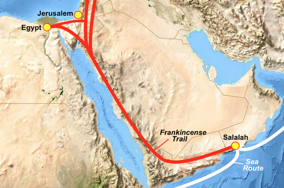
    So whether this was Nephi’s intent or not, he is telling us where he went—in what direction he went—when he left the southern coast of Arabia from the shore of the sea they called Irreantum.
    Now, if he had tried to leave the shore of Oman-Yemen anytime between April and September, his ship would not make headway, i.e., the wind would be before or in front of the ship blowing into his sails from the bow or front of the ship and he would not be able to move forward under any circumstances!
“And it came to pass that the voice of the Lord came unto my father, that we should arise and go down into the ship” (1 Nephi 18:5). Thus, it is obvious that Lehi was told to enter the ship at a time of the Lord’s choosing, which had to have been sometime between October and March, which is referred to as the Winter Monsoon, when the winds blow from the northeast to the southwest. Otherwise, they would not have gotten anywhere for the wind would have been blowing against the ship. Thus, there is no way Lehi could have sailed to the east as all Mesoamerican theorists claim, or as Sorenson put it in his book An Ancient American Setting for the Book of Mormon, “sailing east like the traders had for centuries.”
    However, these traders and fishing vessels were small, coastal vessels, almost flat-bottomed, frail craft meant for coastal currents and certainly not meant for or able to withstand deep ocean pounding of high-velocity waves, cross currents, slamming into troughs from high crests, or withstanding combers, etc.
    Thus, in following the course of winds and currents off the southern Arabian coast during the months of October through March, we find a path heading to the southwest down toward Madagascar, riding through the Somali Current (only possible in January through March), picking up the western swing of the Indian Ocean Gyre that swings south, then southeast, then east that would driver a ship into the Southern Ocean and the high velocity winds and currents of the Prevailing Westerlies and West Wind Drift.
    The Prevailing Westerlies or “Westerlies,” are the anti-trades, that is prevailing winds from the west toward the east in the middle latitudes between 35º and 60º latitude. They originate from the high-pressure areas in the horse latitudes and tend towards the poles and steer extratropical cyclones in this general manner.
They are driven by high velocities referred to by ancient mariners as the “roaring forties,” “furious fifties,” and “shrieking (screaming) sixties.” While modern boat events use these winds for their regatta races around the world, and require expert hands on lines, sails, and boat angles for races, the ancient mariners who used these winds and currents for speed in trade voyages, such as the later fast-sailing clippers that came into being during the middle-third of the 19th century and set world records for shortening the sailing time between the Orient and Britain and the U.S.
    In those ships there was little to do when running the “roaring forties,” or “furious fifties,” but batten down and hanging on. In fact, these Westerlies are particularly strong in areas where land is absent, because land amplifies the flow pattern, making the current more north-south oriented, slowing the Westerlies. The strongest westerly winds in the middle latitudes can come in the “Roaring Forties,” the swiftness between 40 and 50 degrees latitude.
    The Westerlies play an important role in carrying the warm, equatorial waters and winds to the western coasts of continents, especially in the southern hemisphere because of its vast oceanic expanse. And this area of the absence of land is found particularly between New Zealand and Drake’s Passage along the tip of South America. In addition, this route is the shortest distance around the globe and, along with the fast-currents and winds, was the reason the Clippers chose this far southern route to sail their long distances.
    Throughout the year, the so-called “Ugly Westerlies” vary in strength with the polar cyclone. As the cyclone reaches its maximum intensity in winter, the Westerlies increase in strength from west to east and move vessels at high speeds through the empty ocean.
    Due to persistent winds from west to east on the poleward sides of the subtropical ridges located in the Atlantic and Pacific oceans, ocean currents are driven in a similar manner in both hemispheres. The currents in the Northern Hemisphere are weaker than those in the Southern Hemisphere due to the differences in strength between the Westerlies of each hemisphere.
The Southern Ocean: Shortcut from Arabia to the Western Hemisphere. Narrow yellow circle is the Prevailing Westerlies and West Wind Drift; Thick yellow line is Lehi’s Course

Within this Southern Ocean, driven by the Prevailing Westerlies, is the Antarctic Circumpolar Current, or what is more often called the West Wind Drift, an ocean current that flows clockwise from west to east around Antarctica. It is not only the fastest current, but also the largest ocean current.
    Associated with the Circumpolar Current is the Antarctic Convergence, where the cold Antarctic waters meet the warmer waters of the subantarctic creating a zone of upwelling nutrients. These nurture high levels of phytoplankton with associated copepods and krill, and resultant food chains supporting fish, whales, seals, penguins, albatrosses and a wealth of other species. For those who always want Lehi to island-hop across the Pacific for replenishment of supplies, foods, etc., this Southern Ocean is a most amazing fishing ground where the upwelling fish and nutrients that feed them can and do swim right up onto the decks of low-level passing ships and helped keep ancient mariners fed on their long sailing voyages.
(See the next post, “The Death Knell for Mesoamerica – Part II,” for more on how Nephi, Jacob, Mormon and Moroni disqualify Mesoamerica as the Land of Promise)

Monday, December 30, 2019

More Comments from Readers – Part VI

Here are more comments that we have received from readers of this website blog:
Comment #1: “Why do you think Lehi took the course you mentioned from Jerusalem to the Arabian seacoast in Oman? There is a lot of land to the east and south of Jerusalem where they could have gone” Naomi F.
The entire Arabian Peninsula is a desert with limited water except along the coasts. The Frankincense Trail followed the water holes and that is where Lehi would have traveled—or he would have died

Response: First, think “water!” And then think “More water!” As any historian will tell you, Lehi had no other choice but to take a known trail through Arabia, and with the exception of the incense trading route, there were no other trails. It is all a matter of water. Along the Frankincense Trail there are both natural and hand-dug water wells, an absolute essential part of travel in Arabia and the Middle East as a whole.
    Collectively, these trade routes were known as the Frankincense Trail. The incense trails started from places as diverse as the port at Gaza, the rich spice and incense markets of Damascus in present-day Syria, and ancient Babylon, in what is today Iraq.
    These trails eventually ended at one of the major harbors in southern Arabia such as the frankincense harbor at Khor Rori on the coast of Oman. The Frankincense Trail got its name from the primary incense that was transported along it. Myrrh and other incenses and spices were also hauled by caravans along the same trail. In Lehi's time, frankincense grew only in the Dhofar region in southern Arabia; yet, vast amounts of it were used in Egypt, Mesopotamia, Greece, and the temple in Jerusalem. An estimated 3,000 tons were sent to Greece and Rome each year at the peak of the incense trade.
    One of the branches of the trail led to Gaza on the Mediterranean and from there to Egypt by another caravan, where it was used to embalm mummies. Frankincense was also exported from Gaza on ships to Greece and Rome, where it was burned in the houses of the nobility and in their temples. The Gaza branch of the Frankincense Trail passed within 10 miles of the Valley of Lemuel, and we presume that it would have been known to Lehi.
A settlement near the city of Salalah in southern Oman was once a key hub in an ancient trading network across the Arabian Peninsula, with branches into Egypt, moving for incense and spice along these trading routes

Also carried along these trails was myrrh, precious stones, pearls, ebony, silk and fine textiles as well as rare woods, feathers, animal skins, and gold. In the AD period, frankincense was the season of the year when Christians the world over celebrated the birth of Christ and spoke of the visit from the three Wise Men who bore gifts of gold, frankincense, and myrrh, making them the most famous incenses from the Middle East; however uncommon in the Western world. Fortunately, frankincense and myrrh are still available for purchase from the perfume and incense shops in the Middle East though little is transported to the West.
    These Frankincense trails were all interconnected and the main trail southward along the Red Sea and then eastward across the Empty Quarter was the only route available to Lehi and his family as they headed for the Sea of Arabia.
Comment #2: “In the article you wrote about malaria in Rome, I have read where most archaeologists have disagreed with that theory and marginalized David Soren’s work on the children of Lugnano” Carlo S.
Response: It is a long story and was not the main issue of our article, therefore, we did not delve into it enough to relate to your comment and the criticism directed at Soren. However, after many years of David Soren being a laughing stock in the archaeological world, in the late 1990s a British scientist, Robert Sallares, a DNA expert based UMIST (University of Manchester, Institute of Science and Technology), confirmed Sorens work.
    He was particularly interested in using the latest DNA techniques to identify diseases of the past. His main problem was finding bones that might be associated with a particular disease. There was no point in looking randomly at bones from the past, he needed to know that there was a good chance that the person had died of a particular disease. However, for the first time there was a forensic technique that would give cast-iron evidence—but at first, Sallares was unable to find suitable bones, but when he read about Soren's work, he approached him about doing DNA tests. Soren jumped at the opportunity. Not only did Robert Sallares take his theory seriously, but now, for the first time, there was a forensic technique that would give cast-iron evidence either way as to the presence of malaria (once called Roman Fever). Sallares and his team painstakingly analized the bones, searching for the tell-tale DNA traces of the disease. The first four results all came up negative. It was not until Sallares tried the fifth and last bone samples that he finally came up with a positive result. He was able to show the presence of malarial DNA in the leg bones of a three-year-old girl. Because of the way malaria spreads, this particular malaria was most likely part of an epidemic sweeping through a region of Italy (Robert Sallares, Malaria and Rome: a History of Malaria in Ancient Italy, Oxford University Press, 2002).
Monument to Dr. Robert Sallares

The use of DNA probes to identify diseases of the past has recently been applied to many other diseases, including the black death. It is particularly useful in diseases that do not leave tell-tale signs of symptoms on the bones of victims—which is the case with most diseases. For instance, people who die of syphilis have very distinctive malformations on the skull, but malaria only causes signs of disease in some bones—so usually it is only by means of a DNA test that scientists can be positive that malaria was present when someone died.
    The DNA work of Robert Sallares has now confirmed that malaria was a killer during late Roman times. The children of Lugnano died of malaria, and it is likely that there were also many adult victims of the disease, although their cemetery has not yet been found. This would have made it difficult for farmers to collect crops and for the local army commanders to raise troops. What was once a footnote in the history books on the fall of Rome, must now become a whole chapter. David Soren's theory that malaria contributed to the fall of Rome has finally been vindicated.
Comment #3: When did the Panama Isthmus rise up to connect South America and Central America?  I've been assuming it would have been at the death of Christ with the rising of the Andes? But it could not have been until after the last battle of Cumorah or the Nephites would have fled northward as you have pointed out on a couple posts” David K.
Response: I have written about this at least twice in the blog in greater detail with pictures, etc., but briefly, what is called “the Panama knot,” came up at the time of Christ's crucifixion, with all the other turmoil that struck the Land of Promise; however, unlike other areas, such as Mesoamerica which has free passage to the north and south, the land to the north of the Land of Promise (Colombia to Panama), is all high mountains—consequently, for the Pan American highway, and north south movement through these mountains, they had to dig tunnels and extremely dangerous mountain roads just to get to the Gap, yet even today, there is almost no way through the Gap yet established because of its extreme difficulty, certainly impossible for families or even the average person.
A map of the area north of the Land of Promise, i.e., today’s country of Colombia showing the various mountain ranges stretching across any path from Peru northward through Colombia toward Panama

The Darien Gap (Isthmus of Panama) is beyond the country of Colombia, a natural choke point of Central America, and an area almost impossible to cross even today. But to get to this Gap, Mormon and his Nephite armies would have had to cross several mountain ranges of extreme height.
    In modern times, roads were made to go over the mountains, such as the 45-mile-long North Yungas Road, which today is by far the most dangerous on the planet with its 10-foot wide path and 2700-foot sheer cliff drop. It is so dangerous that it has earned the epithet of “Death Road.” Built in the 1930s, the journey from the high mountain plains, through the steep cliffs and hillsides down through the rainforest is the most dangerous on earth and before it was built, no one could traverse this area to the Darien Gap.
    When they build the Pan American highway, which stops in Panama and in Colombia, leaving no road through the Gap, many people died trying to pass along the surface roads until they built the huge tunnel system in 2005, which allows for the first time passage from Colombia to Panama.
    To the north of these mountains is the Isthmus of Darien, an area that even with specially equipped 4-wheelers, has only once been penetrated from north to south by anyone in any capacity, though numerous groups and expeditions have tried.
    Even if Mormon knew about this extension or connection to the north, it would have proven impossible to cross, certainly not with women and children. Thus, the Nephites were boxed in. Only airplanes could fly over the Andes to the east for many years until a road was finally built. In fact, people along that western shelf of the Andes to the sea have called the area an island for its entire existence because there was no way to go east or north until 1) airplanes were used (Jorge Chavez, a Peruvian aviator born in France, tragically died after he successfully air crossed the Alpes by air in 1910, crashing upon landing. Alejandro Velasco Astete, a Peruvian pilot, is well known for being the first man to fly over the Andes in 1925; 2) a railroad was built; and 3) finally the Interoceanic Highway (Transoceanic highway), an international, transcontinental highway in Peru and Brazil resulting from an agreement of the two countries signed in 2004, and the project, known as MTC (Ministerio de Transportes y Comunicaciones) opened in 2005 to 2007.
The building of the roads through the mountain; Left Bottom: One of the roads cut over the mountains; Right: The narrow, steep road through the mountains

Sunday, December 29, 2019

More Comments from Readers – Part V

Here are more comments that we have received from readers of this website blog:
Comment #1: I've spent several more hours reading your blog today. I just want to say thank you. I continue to be very impressed with your work and am thoroughly enjoying your blog” David
Response: Thank you. Glad you are enjoying it.ß
Comment #2: “Why do you keep harping on Hagoth not sailing away in his ships? Sounds reasonable to me that he did” Anthony S.
Response: We don’t harp on his not going—we stress that the scriptural record suggests just the opposite and there is no reason to glean from the record that Hagoth sailed anywhere in the many ships he built. The problem is that modern writers, scholars, theorists and their like who, for some reason, always want to tell us the scriptures do not mean exactly what they say, or say more than they mean, or add to them what is not in the scriptural record, and that they have a better, more accurate, or valuable idea about what was written than we can come up with. Take, for example, George Potter’s comments about Hagoth in his book Voyages of the Book of Mormon that stretches into the imaginative and not at all what the scriptural record tells us: (p175) “So fine was the vessel and so difficult was life in the promised land in his time that it seems Hagoth had no shortage of volunteers willing to sail away with him.”
Response: Nowhere in scripture does it say, hint or suggest that Hagoth ever sailed anywhere in any of his ships, or that anyone sailed with him. Those who boarded the ships were immigrants: men, women and children, with “much provisions” to resettle elsewhere.  It appears from the scriptural record he was a shipwright, a curious man who was a master builder, evidently building ships that were much larger in his day than was commonly known.
    While his ship sailed northward, he remained behind building more ships as clearly stated in the scriptural record: “And behold, there were many of the Nephites who did enter therein and did sail forth with much provisions, and also many women and children; and they took their course northward. And thus ended the thirty and seventh year. And in the thirty and eighth year, this man built other ships. And the first ship did also return, and many more people did enter into it; and they also took much provisions, and set out again to the land northward” (Alma 63:6-7).
    That is, his ship sailed in the 37th year and returned in the 38th year, and while that was going on, before the ship returned, “this man built other ships.” There is no way from this to conclude that Hagoth sailed away anywhere, let along with him. It is this tendency of theorists to make up things not found in the scripture that tend to defeat their efforts and cast a questionable shadow over the scriptural record itself.
    However, not finished with this fictitious storyline, Potter also wrote: (p176) “A year later, Hagoth returned and built other ships. With his enlarged fleet, he took many more colonists northward from Peru” (Alma 63:7).
    Response: Again, there is no reason to even think that a shipbuilder, busy “building other ships” was also sailing off into the sunset in one of his ships. It might make a romantic picture, but does not fit the scriptural record nor the historical fact that shipwrights who spend their time building ships are also explorers—Columbus did not build his ships, neither did Drake, Magellan, Cook, de Gama, Ponce de Leon, or scores of others. After all, ship-building is very different than ship-sailing, and both take an extreme amount of skill and professionalism, but are very rarely found combined.
    And another Potter comment: (p176) “However, Hagoth was not the only shipbuilder at the time. Another ship was built that perhaps followed Hagoth’s instructions for traveling north” (Alma 63:8).
Hagoth was a shipwright, i.e., he built ships. The scriptural record gives no suggestion he ever sailed anywhere in the ships he built

Response: Again, there is absolutely nothing in the scriptural record to suggest such a thing. The point is, beside feeling like the scriptural record is one’s own personal invitation to make it different, adding events and circumstances, and different meanings than originally intended, it lessens the value of the ancient writing into a text that was meant for others to expand upon, change, alter, and obfuscate in any way a writer chooses.
    There is no question that the Nephites were involved in shipping and ship-building (Helaman 3:14), it might even be reasonable to suggest that there were other shipbuilders than Hagoth, which would seem a likely scenario given Helaman’s comment that singles out shipping and shipbuilding from all the business and merchant occupations the Nephites might have been involved in; however, to go further does little purpose and usually leads one down a false path, away from the issues at hand.
Comment #3: Why does Nephi distinguish between goats and wild goats. Is he speaking of something besides domesticated vs wild goats? Also, an ox is a domesticated and castrated bovine draft animal. This leads me to wonder if there were already people living in the promised land. Please give me your opinion on this. I really am very curious as to why these specific animals are mentioned in the scriptural record” Matt B.
Response: First of all, we have written a few times about the wild ox, so rather than write it again, let me refer you to the main article, “The Question of oxen in the Land of Promise,” published Sunday, December 2, 2012, in this blog.
The wild goat is a separate species from the domesticated goat, not just undomesticated
The Pasang (Capra aegagru) is a wild goat of Iran; Capra falconeri, markhoor (marhkor), is a wild goat of the Himalayas; Capra Ibex, Ibex, wild goat of Eurasia and north Africa, etc. Domesticated goat is a Capra aegagrus hircus
    As for the wild goat. It would appear that Nephi, undoubtedly knowledgeable and experienced at farming, living all his life just outside Jerusalem (1 Nephi 1:4), would have been thinking of this difference. The wild goat (Capra aegagrus) is a widespread species of goat, with a distribution ranging from Europe and Asia Minor to central Asia and the Middle East. It is the ancestor of the domestic goat. It should also be kept in mind that the domestic goat has become established in some areas in the wild as a feral animal—an anima living in the wild but descended from domesticated animals. That is, a feral animal is one that has itself escaped from a domestic or captive status and is living more or less as a wild animal, or one that is descended from such animals.
    As to why Nephi distinguishes between goats and wild goats, seems to be in two parts: 1) The Jaredites brought over domestic goats (Ether 1:41; 9:18), and it would appear that during the time they lived in the Land Northward of the Land of Promise, some of these goats may have escaped into the wild and became feral; 2) The following statement of Nephi gives us a further clue, “and the goat and the wild goat, and all manner of wild animals” (1 Nephi 18:25). That is, it appears Nephi was distinguishing between this type of wild animal (a feral goat) with the more natural wild animals, such as puma, jaguar, bear, or even the monkey. What wild animals the Jaredites brought with them we are not told, but some such animals were obviously brought with them (probably as cubs in the barges) to repopulate the Western Hemisphere after the Flood.
Comment #4: “Del, there is hardly a day that goes by that I am not here learning. Thanks for doing more than just writing your books” Mr. Nirom.
Response: Thank you.
Comment #5: “Regarding your post “The Island of South America Part IV,” the East Sea is never mentioned after the destruction. Brilliant Del. I never thought to distinguish the geography mentioned pre and post 33AD. But now that you point it out it seems so obvious. The last mention I see of Eat Sea or sea east is in Helaman 11, right before the birth of the savior. You continue to impress me, Del.”
Response: I thought the omission, the first time I noticed it, was interesting and answered the question of the rising of the Andes and the disappearance of the Sea East.”
Comment #6: “On More Comments and Questions from Readers. Love it! Very interesting topics. I hope the incoming comments and suggestions are equally positive. Thank you for sharing this information that is actually helpful” Lee W.

Saturday, December 28, 2019

More Comments from Readers – Part IV

Here are more comments that we have received from readers of this website blog:
Comment #1: “Inevitably, the idea of creationist ideas leads to their claims being exposed as wrong or even foolish. For example, anyone who cares to do so can add 4004 BC to 1983, and find that Archbishop Ussher's biblical age for the universe is 5987 years. Some quick addition of the begats in Genesis shows that Noah's flood came 1646 years after the creation. That adds up to 2348 BC, or 4331 years ago. If Henry Morris (1980) is right that "all true facts of nature" support Biblical creationism, then the student of history would expect to find signs that some of the Egyptian pyramids had been inundated. Rather than confront fact after fact that refutes their deeply held beliefs, scientific creationists simply attack the theory of evolution and make vague claims that their own "model" is supported by abundant scientific evidence” Jason T.
Response: You base your argument on the validity of carbon-14 dating of the pyramids. Since no one was around at the time of the Flood, nor anyone around at the time of the building of the pyramids, there are only two things that can determine the age of each—and that is the Bible. If we take the Bible for its word, which in the case of the Flood, then we have to find some equally written idea of how old the pyramids are, which we only have guesses about from archaeologists.
    In fact, archaeologists believe Egypt’s large pyramids are the work of the Old Kingdom society that rose to prominence in the Nile Valley after 3000 B.C. Historical analysis tells us that the Egyptians built the Giza Pyramids in a span of 85 years between 2589 and 2504 B.C. However, though not well publicized, in 1984 radiocarbon dating on material from Egyptian Old Kingdom monuments (financed by the Edgar Cayce Foundation), showed the results to be 374 years earlier than expected, making the above dates 2215 B.C. to 2130 B.C.
    To the researchers “the radiocarbon dates confirmed that the Great Pyramid belonged to the historical era studied by Egyptologists.” The same group took sample measurements from an intact bakery in 1991 and found the dates tended to be 100 to 200 years older than the Cambridge Ancient History dates, but 200 years younger than their 1984 dates, putting the dates then at: 2015 B.C. to 1930 B.C. They did not adjust the earlier figures, still using the older dates for publication, though their own graph shows dates falling between 2200 and 1650 B.C., with an average date of 1900 B.C.
The results of the pyramid dating (Senwoset II), Georges Bonani et al., "Radiocarbon Dates of Old and Middle Kingdom Monuments in Egypt, Radiocarbon, Vol.43, No.3, 2001, pp1297-1320)

    Also, two caveats need to be considered: 1) All dating was of wood samples and there is no way of knowing if that wood was brand new (newly cut) at the time of use, or was harvested from other timber or previously used wood; 2) As has been stated in this blog so many times, Carbon-14 dating is erroneous to begin with and almost all dates prior to the time of Christ are older than they show. In addition, with all this, all of the dates shown and arrived at in these tests were after the Flood, which according to Moses occurred in 2344 B.C.
Comments #2: "If Lehi traveled along the Frankincense Trail why did they need the Liahona to show them the way? They could have just walked along the road with everyone else" Barb O.
Response: That seems to make sense until we realize that the Frankincense Trail was not a road in the sense that we understand today. There was no delineated trail along which to walk. It was simply a general course that would take one to the next caravan halt and water. Sometimes the width of the area in which they traveled was several miles wide. Assuming Lehi had not been this way before, he probably would have needed a guide of some sort to show the way from waterhole to waterhole.
    In those times when the colony traveled alone, the Liahona would have been absolutely necessary. While it is understandably normal to think in modern terms for us today, we have to keep in mind that in 600 B.C. there were few people in the area Lehi traveled, they were often not friendly, and frequently, the areas were claimed by local emirs who jealously guarded their lands and waterholes. It would seem that Lehi, as much as possible, would have kept to himself where it was practical for him to do so.
Comment #3: “You quoted recently that “Mesoamreica has become the focal point for understanding the Book of Mormon. Sorenson’s landmark work, ‘An Ancient American Setting for the book of Mormon’ ably demonstrates that [Mesoamerica] is a plausible geographic and cultural setting that an accommodate the Book of Mormon test” but did not give a reference. Who was this author?” Carla W.
Response: Jeff Lindsay and David C. Coles “Plain Reasoning and Empirical Findings that Support the Book of Mormon,” from Lindsay’s “Book of Moron Evidences and Book of Mormon Nuggets” and Coles: “Is the Book of Mormon Really an Ancient book?” as quoted by David Van Alstyne on his webpage http:/davidvanalstyne.com
Comment #4: “After 12 years of moderate studying of all other possible theories, last January I found this blog and have spent many, many hours reading each post. I also have read much concerning the worlds historical view of South America. I hate the fact it happened in South America, it shatters so many theory's ideas, thoughts, and books. Not to mention Tennis Shoes Among the Nephites. J Never the less what an amazing marvelous culture. I love this blog I love this research. Thank you for all your work!” (unsigned)
Response: Glad you are enjoying it, and thank you for your kind words.
Comment #5: “I read where someone thought Lehi was in the caravan business because he had tents (1 Ne 2:4) and camels” Jenkins D.
Response: First of all, Lehi would not have had camels in or around Jerusalem because the land on the mountainous area is covered with sharp shale rock chips that would cut the soft underfoot of camels who require either soft sandy or solid ground to walk on. In fact, camels never traveled into the mountains anywhere unless there was a wadi, or a series of wadis that drained rain run-off from the mountain out into the desert, allowing for sandy travel into the mountains.
Anciently camel markets were located along the Frankincense trail to the south of the Dead Sea for travelers to Egypt or Arabia

So once Lehi left the mountainous area south of Jerusalem and entered the Wadi Arabah, he would have traded his donkeys for camels at one of the many camel markets that existed at the time (and even today) for the continuance of his journey down the Red Sea and across the Empty Quarter.
    Secondly, the possession of tents have nothing to do with the caravan business since caravans did not travel with or use tents—they slept on the sandy ground at night, with their camels, guarding the loads or merchandise. One needs to keep in mind that the tents the Bedouins had were very large, weighing some 500 pounds of goat hair, plus tent poles, inner rugs and dividers, etc. 
    It usually took several hours to an entire day to unpack and set up a Bedouin tent, and then again another similar length of time to take one down and pack it away. This would have been unnecessary delay in the basically speedy travel of a caravan across the desert wastes. When Bedouins (or Lehi) traveled with tents, they were not set up each night, but only after a lengthy travel period, and were done so around or near a waterhole or oases where the people spent several months to graze their cattle, goats, or horses before moving on to another location. In the case of Lehi, Nephi writes that they tarried for a while when they stopped (1 Nephi 16:33), meaning they spent some time, perhaps weeks or more before continuing.
    After all, Lehi did not travel down the Red Sea in one winter traveling season. Including crossing the Empty Quarter when he headed nearly eastward, he spent eight years in the wilderness. It should also be kept in mind that it is impossible to travel in Arabia during the hot months of May through October, Lehi would have stropped for the summer to rest because the temperatures along the trail are consistently over 120ºF in the shade, beginning in late spring. Obviously all travel along the Frankincense Trail would have ground to a halt in then through the summer.

Friday, December 27, 2019

More Comments from Readers – Part III

Here are more comments that we have received from readers of this website blog:
Comment #1: “Since the people who traveled north in the ships that Haggoth built was in about 50BC, that would put the building of MesoAmerica 550 years later after Lehi had arrived. So it is obvious that there was no building going on in MesoAmerica. Problem is they needed to look southward and then they would have thought much differently! But they are making their statements based on what they actually see in MesoAmerica.. which was nothing because no one was really there” Mr. Nirom.
Top: The famed Chichen Itza on the Yucatan Peninsula and (Bottom) Coba in Quintana Roco, Yucatan, were built by the Maya and thrived from 600 to 1221 AD

Response: Mayan civilization flourished between 300 and 900 AD and once consisted of over 40 cities spread across southern Mexico, Guatemala, Honduras, and northern Belize where there are some of the most impressive ruins of these ancient cities that can be visited today.
    As we have written in these articles in the past, the "hard evidence" of Mesoamerica, i.e., the dating of buildings and structures carry dates of 100 B.C. to 100 A.D. onward into A.D. time, which matches perfectly the Hagoth ship immigrants. We need to keep in mind that this immigration started then but continued onward in time. Any dates before this time are based more on archaeological and anthropological assumpti1 ve development belief than hard evidence.
Comment #2: “Hikayat Merong Mahawangsa is fictitious. During the Langkasuka period, Ligor (Nakhon Si Thammarat)!played an important role. Each province was a assigned to a zodiac sign. Kedah was assigned to big serpent or dragon zodiac sign. Dragon in Siamese is 'marong'. 'Mahavamsa' is chronicle of rulers in Ceylonese tradition. Merong Mahawangsa = Chronicle of Kedah” Adrina.
Response: Nakhon Si (or Sri) Thammarat is a city (“Thesaban nakhon” meaning “city municipality”) in southern Thailand, and capital of the Nakhon Si Thommarat Province, which is located about 380 miles south of Bankok on the east coast of the Malay Peninsula. It is one of the most ancient cities of Thailand, previously the Kingdom of Ligor, and contains many buildings and ruins of historical significance; however, most of these were not built until 775 A.D. when the king of Srivijaya “had established a foothold on the Malay Peninsular at Ligor,” and “where he built various edifices, including a sanctuary dedicated to the Buddha and to the Bodhisattvas Padmapani (“enlightened Lord who looks down”) and Vajrapani (Budha’s Power).
Map of Southeast Asia in the 1400s, with the various Kigoms and Empires shown A.D. Blue Violet: Ayutthaya Kingdom (Siamese kingdom 1351-1767); Dark Green: Lan Zang; Purple: Lanna; Orange: Sukhothai Kingdom; Red: Khmer Empire; Yellow: Champa; Blue: Dai Viet

The Kingdom of Ayutthaya (Ayudhya) was a Siamese kingdom that existed from 1351 to 1767. Ayutthaya was friendly towards foreign traders, including the Chinese, Vietnamese, Indians, Japanese, Persians, and later the Portuguese, Spanish, Dutch, and French, permitting them to set up villages outside the walls of the capital, also called Ayutthaya.
    In the sixteenth century, it was described by foreign traders as one of the biggest and wealthiest cities in the East. The court of King Narai (1656-88) had strong links with that of King Louis XIV of France, whose ambassadors compared the city in size and wealth to Paris.
    By 1550, the kingdom's vassals included some city-states in the Malay Peninsula, Sukhothai, and parts of Cambodia. In foreign accounts, Ayutthaya was called Siam, but many sources say the people of Ayutthaya called themselves Tai, and their kingdom Krung Tai, 'The Tai capital'. The word “krung” has alternative meanings, as does “tai,” but in this context Tai capital is appropriate.
    According to the most widely accepted version of its origin, the Siamese state based at Ayutthaya in the valley of Chao Phraya River rose from the earlier, nearby kingdoms of Lavo (7th A.D. Century until 1388 A.D.), which at that time was still under the Khmer control) and Suphannaphoom (Suvarnabhumi). One source says that, in the mid-fourteenth century, due to the threat of an epidemic, King U Thong moved his court south into the rich floodplain of the Chao Phraya (a River that flows through Bankok and into the Gulf of Thailand) on an island surrounded by rivers, which was the former seaport city of Ayothaya, or Ayothaya Si Raam Thep Nakhon, the Angelic City of Sri Rama (“The Foundation of Ayuthia, Journal of the Siam Society, Vol1, 1904). The new city was known as Ayothaya, or Krung Thep Dvaravadi Si Ayothaya. Later it became widely known as Ayutthaya, the Invincible City (“The Tai Kingdom of Ayutthaya” The Nation: Thailand’s World, 2009).
    However, the point of all this is not such modern historical information, but the B.C. period of the area and whether or not people lived on the Malay Peninsula during 600 B.C. through the early A.D. period. There is so little on the Malay Peninsula to match the Book of Mormon record that though Olsen has written much about it, the concept simply does not fit into the period of time and the events described in the scriptural record.
Comment #3: “Nauvoo was in Hancock County, an established area with a significant non-Mormon population that included the reasonable sized towns of Warsaw and Carthage. As with the church’s experience in Kirtland, it would be difficult and expensive for poor church members to gather to the area and buy farmland (and conflict with existing “old settlers” was almost inevitable). Iowa, by contrast, was wide open. For an industrious, agricultural people, land was the key ingredient to fuel a successful settlement. With hindsight, it’s very clear that Zarahemla should have become the church’s headquarters. Nauvoo was a mistake” Brigham B.
Response: “Perhaps. We will never know; however, one thought to consider. If the Saints had been well received in Iowa, and not driven out, most may never have gone to Salt Lake Valley, and settled Utah, and all the wonderful things that occurred in connection with that event might not have happened. In addition, while Utah did not become a state until January 4, 1896, after the Church was very well established in Utah territory, Iowa became a state on December 28, 1846, which would have held far more difficulties for the Saints, including voting block problems within a state, while the Church was quite young and under populated, which probably would have affected polygamy, the growth of the Church, and forced Church members into social interaction long before they were in Utah.
Comment #4: “Three times in this article (Is the Chile Landing Site a Myth? Part I) you referred to Ralph G. Williams, but did later in the article referred to Fredrick G. Williams. I am assuming here that Fredrick was to be the name used through out the article” Mr. Nirom.
Response: My apologies. Old age must be taking its toll :) The name, of course, is Fredrick Granger Williams.
Comment #5: “It seems that the 30 degrees south latitude in South America landing site for Lehi was speculated by Frederick G. Williams, not Joseph Smith. What is your source for it being Joseph's? Thanks,” Kyle E.
Response: No source. It is a matter that cannot be proven one way or another. However, given the circumstances as Williams being Joseph Smith’s scribe and secretary, plus being a member of the First Presidency at the time, and the fact that other important comments were written on the same paper (paper was not plentiful in 1840s, it was costly, and most used every piece completely), it seems likely it was a discussion between Joseph and among his Presidency. Whether or not it was a prophecy as people argue about, the point is that it was written down—an area that so well matches the landing site of Lehi that it is remarkable at all to have been thought of it a time when no one in the U.S was familiar with Coquimbo Bay and its harbor and landing site, no one knew that La Serena had a Mediterranean Climate that would have grown the seeds from a like climate in Jerusalem, nor would they have known about the several other things, including the abundance of precious metals in natural ore surface sites, etc.
    There is so much to warrant the area, that for someone to have come up with the idea out of the blue is very improbable—Las Vegas would give you a million to one odds. Another point, Orson Pratt speculated on a South America west coast landing, but picked Valpraiso, a city that would have been known in the U.S. as a major port and population center; however, it would have been much further to the south, and would not have had the climate. Lastly, while the Mesoamericanists and other church scholars and writers of a location for the Land of Promise can only claim that there is no proof that William’s unsigned, undated writing represents a revelation given to Joseph Smith, the point is the location showed up on the paper and would not have been any reason to claim it in 1840.
    Only in the last few decades has this area become known and understood to match the writings of Nephi toward the end of the 18th chapter of his first book.

Thursday, December 26, 2019

More Comments from Readers – Part II

Here are more comments that we have received from readers of this website blog:
Comment #1: “I just completed the lengthy job of reading all your blog from beginning to now. I can’t begin to tell you how much I appreciated the information and the marvelous education it gave me on the Book of Mormon. Thank you very much. Next, I’ll tackle your books” Chuck G.
Response: Thank you for your kind words. There is much to learn in this never-ending process of seeking knowledge.
Comment #2: “Hi Del, in certain circles this would be considered "plagiarism". You need to attribute the content of this post to the original author, and that isn't you” David P.
Response: That is correct, we did not write it nor did we take any credit for it, post it under the name of anyone in our organization, or who send us information. In fact, much of the technical information we use in our blog comes from other sources, many of them, like this article, “Thinking in Eastern Concrete Terms, or Western Abstract Terms?” appeared on a website “Ancient Hebrew Research Center, Plowing through history, from Aleph to Tav,” and contained information regarding the Hebrew language, regarding the question “Does the English translation of the Bible accurately reflect the Hebrew?” and allows for free use, copy or distribution, by Jeff Benner, who we have credited in the past when referencing Hebrew language. For whatever its worth, this is not a new subject—I have been teaching it Sunday School classes on Old Testament since back in the 1970s, though I am no expert on the subject, which is why we relied on Benner's view in the blog.
Comment #3: “Radiometric dating, which you wrote critically about is the process of determining the age of rocks from the decay of their radioactive elements. You neglected to mention this has been around and much in use for over fifty years. There are also more than 40 other like techniques, though each used a different radioactive element or a different way of measuring them. It all sounds pretty solid to me” Granger L.
Precambrian shield at Godthåbsfjorden, West Greenland consists dominantly of crystalline gneiss basement, formed during several periods of mountain building, and welded together. The oldest rocks about 3.9 billion years old occur in the Isua region to the south, whereas the area around Ilulissat is formed by younger rocks about 1.8-1.6 billion years old

Response: Located on the west coast of Greenland, 250 km north of the Arctic Circle, Greenland's Ilulissat Icefjord is a tidal fjord covered with floating brash and massive ice, as it is situated where the Sermeq Kujalleq glacier calves ice into the sea. In winter, the area is frozen solid.
    Issua fjord in Greenland, Located on the west coast of Greenland, 155-miles north of the Arctic Circle, Greenland's Ilulissat Icefjord is a tidal fjord covered with floating brash and massive ice, as it is situated where the Sermeq Kujalleq glacier calves ice into the sea. In winter, the area is frozen solid. Here the oldest rocks about 3.9 billion years old occur in the Isua region to the south, whereas the area around Ilulissat is formed by younger rocks about 1.8-1.6 billion years old. This Precambrian shield is dominated by pale grey, folded, gneisses and granites, with bands and enclaves of mica schist and dark basic rocks.
    It should also be noted that just because a method has a long history, or is popular, or gives consistent information does not mean it is true. After all, similar claims were made about spontaneous generation, though now it is an obsolete body of thought on the ordinary formation of living organisms without descent from similar organisms (it was originally thought that maggots could arise from dead flesh). Similar claims were once made about phlogiston, which now is an obsolete scientific theory that postulated a fire-like element called phlogiston, contained within combustible bodies and released during combustion. The name comes from the Ancient Greek phlogistón (burning up), from phlóx (flame).
Comment #4: “Excellent posts about the age of the earth, carbon dating, etc. Clears up a lot of questions I have had over the years about why dates of carbon dating do not line up with scripture. Thank you Del” David K.
Response: Again, thank you for your kind words. It is nice to know how people feel about what we post. We receive far more accolades than we post in these comments, but once in a while we put one in. Another good source, though far more technical, is our book Scientific Fallacies & Other Myths.
Comment #5: “Whatever exact and clear glimpse of the Land of Promise the Book of Mormon gives us is more than obfuscated by the writer of this review, who never quite gets beyond his criticisms to show us the error of the Mesoamerican theory or the more compelling theory he/she may hold to” John R.
Response: Perhaps you would care to read more of our comments about Mesoamerica, for in them we have taken every single point about Mesoamerica and compared it with scripture in order to show that their model simply does not agree with Mormon's many descriptions. It is not that we are critical of Mesoamerica, we are critical of those who misuse, misinterpret, change or alter the scriptural record in order to promote their pre-determined location and view. We also recommend you to the book "Inaccuracies of Mesoamerican and other Theorists" for a complete coverage of several Mesoamerican theorists writings and claims and comparing them to the scriptural record. We might also add that we have written this blog for almost ten years with over 4000 posts covering a very wide variety of issues about the Land of Promise. We do not center on criticism of Mesoamerica, but do write about scholars who place the Land of Promise in areas not consistent with Mormon’s descriptions. Perhaps you would want to read our descriptions of the Land of Promise before commenting about our narrow view and “never quite gets beyond his criticism” to see what else is covered very extensively throughout the ten plus years of our blog.
Comment #6: “I find it odd that in Alma 2:24 it mentions the Nephite city of Minon being “above the land of Zarahemla,” which places Minon north of Zarahemla, however, Minon was on the way to the Land of Nephi. Why did they have to go north to go south to Nephi?” Toby R.
Response: In the 1828 American Dictionary of the English Language, the word “above” is defined as “literally, higher in place” and “overhead, in a higher place.” In fact, there are numerous meanings of the word “above,” but in geography, it means only above (higher in elevation)—it does not mean north. Consequently, when comparing this to other scripture showing that the Land of Nephi was “above” or at a higher elevation, than the Land of Zarahemla, we see that the scripture being referred to reads: “Behold, we followed the camp of the Amlicites, and to our great astonishment, in the land of Minon, above the land of Zarahemla, in the course of the land of Nephi, we saw a numerous host of the Lamanites; and behold, the Amlicites have joined them” (Alma 2:24). That is, Alma was pursuing the Amlicites but when it got dark and he could follow them no longer, he sent out Zeram, Amno, Manti and Limher to keep track of the Amlicites, and in the morning they returned “in great haste, being greatly astonished, and struck with much fear (Alma 2:23), saying that the Lamanites were hurrying down to attack Zarahemla.
What you quote seems to be taken from Geography—Book of Mormon.com, “Why is There So Much Geography in The Book of Mormon That Relates to War?” by Steven Nelson, who seems to have his geography all screwed up with the Lamanites “have to go north to get to Zarahemla though it was south, and had to go around an inland sea.”
Comment #7: I agree with James Lee Warr and his Costa Rica land of promise, about which he said among other things, It was an area where tropical diseases (i.e. fevers) and their remedies were present” (Alma 46:40)” Ralph L.
The malaria treating drug quinine comes from the bark of the ‘cinchona’ tree, which grows only in Andean Peru, was discovered by the Quechua people of Peru and Bolivia and later brought to Europe by the Jesuits

Response: There was only one true cure for fevers anciently, especially for malaria which killed so many people throughout the world, and that was quinine, which was found only in Andean Peru until the Dutch transplanted it into what is now Indonesia in the 16th century. The actual scripture referenced is: “And there were some who died with fevers, which at some seasons of the year were very frequent in the land –  but not so much so with fevers, because of the excellent qualities of the many plants and roots which God had prepared to remove the cause of diseases” (Alma 46:40). It is interesting of all the malady treatments for fevers found all over the world, only quinine was effective. They did not have quinine in Central America, in Mesoamerica, in the Heartland, Great Lakes, or eastern U.S., so we can simply conclude that quinine, being the only cure for deadly fevers in ancient times, locates the Land of Promise in Andean Peru.
Comment #8: “Do you have a place where you think Nephi’s brothers were going to cast him into the depths of the sea?” Marlene A.
Response: Guarding both sides of the entry to the Khor Rori inlet are great granite cliffs. The cliffs reach a height of 100 feet and project out into the deep water a length about 200 feet, thus providing a natural breakwater for a safe passage to the sea far beyond the breaking surf zone. Phillips describes this remarkable passage into the deep water: “at Khor Rori two elongated monoliths of rock flank the entrance to the khor and defy an obvious geological explanation. We can also suggest that these cliffs make a perfect “mountain” from which Laman and Lemuel threatened to cast Nephi into the depths of the sea
Comment #9: “Thank you for your work Del. I am finding your blog to be fascinating and compelling. I have studied many of the mesoamerica books and thought that was likely the promised land but struggled with some aspects of the model like the sea east and west being north and south— and the narrow pass being a flood zone, etc. I was quite impressed with George Potter's work on Lehi's trail in Saudi Arabia, but did not find his initial reasons for the promised land being in Peru to be very compelling –  but as his work continued I found it more compelling and then I found your site which I am impressed with. I am reading your blog from the oldest post first as well as all comments” David K.
Response: Thank you for your positive comment.

Wednesday, December 25, 2019

More Comments from Readers – Part I

Comment #1: “The problem, as I see it, is that you are letting the only system regarding directions you know suggest that it is the only possible system anyone else could know. Don't confuse the terms for the directions—and  remember that the Book of Mormon is a translation. So we don't know the original word, just that Joseph chose to call it north” Quinn B.
 
Response: Numerous tests have shown that people use different ways in which to communicate directions. Europeans are more inclined to use up, down, right, left, backward and forward, where Americans are more inclined to use street names. Northeastern and southeastern Americans are more inclined to use physical objects: “You go down this street to the bridge and turn right,” while mid-westerners and easterners are more inclined to use street names, and westerners of the U.S. inclined to use personal and obvious references: “Turn left for three blocks, then turn right for five blocks, pass the Wal-Mart and…”
    However, all have shown a knowledge and use of cardinal and ordinal directions on more specific points: “The pharmacy is on the north-east corner of 5th and Main Street.” “There is a Piggily Wiggily over in Taylorsville, about five miles north of here.” Then, too, pilots relate to directions differently than mariners, athletes differently than accountants, etc.
    Over the centuries, the principal direction has changed from east to north in the Western Hemisphere. The word “orientation” originally meant “east” from “orient,” but that emphasis has changed to “north” in the recent era. East is the principle direction in Asia, the Middle, Far and Near East, while “south” is the principal direction in China—in fact their word for compass is zhinazhen, meaning “south-pointing needle.” They also have the same word for back as north, similar in purpose as the ancient Hebrews who were oriented to the East and had the same word for back as West.
    The point is, however, that all these cultures, the major cultures and civilizations of the Earth, all had and have the four cardinal directions in the same place and always have had. To think that directions (north, east, south and west) are different with different meanings or locations among any society is simply not true and has no validity among Earth societies.
    As for Joseph Smith “choosing to call it north,” suggests you are completely unaware of how the translation of the plates took place. We have written several articles on this, and the Church website and other sites have several articles, quoting those who worked with him in the translation, including his wife, Emma, describing how that was done.
In no way could it be said, “Joseph chose to call it north.” He read off the word as it appeared on the seer stone and it was written down by the scribe, who then repeated it. If the word was correct, it disappeared and another sequence appeared. If it was incorrect, the word remained until it was corrected. This system, employed by the Spirit, did not leave room for error. If Joseph said “north,” it was because that was what the translation process determined.
Comment #2: “I found it interesting that on then Church website," under “The Mulekties,” and subheading “A Colony is Established in the Promised Land,” it states: “The Book of Mormon gives us some general proximities of the Mulekite, the Nephite-Lamanite, and the Jaredite civilizations. “Now the land south was called Lehi, and the land north was called Mulek” (Helaman 6:10). Alma, in describing the city Bountiful, wrote that Bountiful was “so far northward that it came into the land which had been peopled and been destroyed … , which was discovered by the people of Zarahemla the Mulekites, it being the place of their first landing” (Alma 22:30).  They left out the most important part about the people of the bones, etc.” Randy W.
Response: First of all, the author stated the scripture wrong when he said it was Bountiful that was so far north. The scripture (Alma 22:30) is about the Land of Desolation, not Bountiful. Second, you are correct in their leaving out the reference to the Jaredites, whose place of first landing this was referencing. I guess you can say you can’t even believe what is written on the Church website. However, we should keep in mind that this article, though on the Church website, was written by Garth A. Wilson, of Blanding, Utah, who by the way was a winner of the 1987 Writing and Music Contests for the Ensign Magazine, who won $400 for this first place article “The Mulekites.”
    It is hard to believe! He misquotes a scripture with a glaring mistake, then leaves out an important part of another scripture, giving an entirely wrong idea, and wins $400.00.
Comment #3: “I received a response from a Mesoamericanist the other day to my question about Jacob’s comment a bout being on an “isle of the sea,” in which he responded: “By the way did you know that in Hebrew usage, “isle of the sea referred to a coast, not necessarily an island. Secondly, Nephi uses the phrase to tie his people directly to Isaiah’s promises about the isles of the sea. It disappears after that.” Don’t you find that interesting?” Mr. N.
Response: There are three really important errors this Mesoamericanist makes. 1) The Book of Mormon was not written originally in Hebrew, but in Reformed Egyptian, and we do not know what words or hieroglyphs of that language were used or their meaning—however, Joseph Smith translated it in English as “isle of the sea,” a phrase that in 1829 New England where Joseph was located and grew up, meant “an island in the midst of the sea,” which phraseology is verified by Jacob’s following statement, “but we have been led to a better land, for the Lord has made the sea our path, and we are upon an isle of the sea,” can hardly be suggested to be a coast (emphasis added);
2) It was not Nephi who said that, but Jacob, speaking during a two-day General Conference of the Church within the Temple in answer to a concern shared by the membership about them (Nephites) being forgotten of the Lord since they were no longer in Jerusalem and has nothing to do with tying the Nephites to Isaiah—in fact, it was not about Isaiah at all, other than the fact that Isaiah also used the same phraseology and, therefore, was being shown to know about the Nephites and that they were not forgotten of the Lord; 3) Nothing disappears after that; the point being that the Nephites knew they were on an island, being on an island was not the question or the concern, nor was Isaiah, but that the Nephites felt the Lord had forgotten them, thus Jacob states: “let us remember him, and lay aside our sins, and not hang down our heads, for we are not cast off” (2 Nephi 10:20).
    Your Mesoamericanist, like other Mesoamericanists, seems to miss the entire point of the scriptural reference. Obviously, one must understand no prophet of God is going to stand up in General Conference and lead the Church astray with a completely erroneous comment that, in this case, is verified by the Spirit through Joseph Smith’s translation. It is a shame how far astray from the gospel that Mesoamericanists can get in trying to maintain their personal pre-determined viewpoint when it is so contrary to the scriptural record.
Comment #4: “I am more interested in determining which river was the river Sidon, and where the head of the river Sidon was. Priddis has interesting ideas about it, but I have never fully accepted them. When I look at each instance of the word "Sidon" in the Book of Mormon the river is clearly North-South, but the direction of the flow is not given. But since the head of the river Sidon clearly is put in the wilderness between the Nephites and Lamanites it only makes sense the river ran to the North. When I look at a map of the area, the Montaro (the Priddis choice) does seem the best choice, but it runs South. However, it joints other tributaries and collectively they eventually run North. So my question is: Was it common for Hebrews and/or Egyptians to name a river and include all its tributaries with the same name?” eRichard
The Mantaro River flows to the south out of Lake Junin and past Lima (Zarahemla), then curves and winds its way into the Apurimac to flow north into the Ene and finally the Ucayali River and the Amazon River beyond

Response: Since the great destruction of mountains crumbling into valleys and valleys rising to mountains “whose height is great,” It seems likely that the flow of the river(s) of the Land of Promise would have been affected. All common sense suggests that the Sidon River did not continue in its previous state after all of this destruction and drastic change in topography, rise of the Amazon drainage basin, etc. However, none of our extensive study on this has proven of any value in determining such an event. The only clue is that after 3 Nephi, the Sidon is mentioned only once, and not as a river, but as the “Waters of Sidon” (Mormon 1:10), which is a term used three other times in the scriptural record, but one would expect it to be Sidon River in this case. 
    Also, the Mantaro River has its headwaters or source to the north of Zarahemla in Lake Junin, not the south as the scriptures clearly state, and from there it runs south until joining the Apurimac and eventually the Ene—it is interesting that in this “fish hook” movement can be worked into the scriptural record descriptions as Priddis and Kocherhans clearly did. However, but one cannot be comfortable with that—the fact that it runs south past Zarahemla should eliminate that. It is possible that the lowering and rising of mountains changed that source, but there is no way of verifying that at this time.

Tuesday, December 24, 2019

Comparing Land of Promise Location to Scripture Descriptions

When looking for a Land of Promise location model, it should, above all else, match the descriptive statements in the Book of Mormon about such a location. If any model does not match Nephi, Jacob, Mormon and Moroni’s clear statements, then it should be summarily rejected.
Ammon reached “a hill, which was north of the Land of Shilom, and there they pitched their tents, and Ammon took three of his brethren and they went down into the Land of Nephi

As an example, Mormon tells us that the cities of Shilom and Shemlon were within view of a tower built on a hill overlooking the city of Shilom. “[Noah] built a tower near the temple; yea, a very high tower, even so high that he could stand upon the top thereof and overlook the land of Shilom, and also the land of Shemlon, which was possessed by the Lamanites; and he could even look over all the land round about (Mosiah 11:12, emphasis added).
    This tower was on a hill which Mormon tells us: “He [Noah] caused many buildings to be built in the land Shilom; and he caused a great tower to be built on the hill north of the land Shilom, which had been a resort for the children of Nephi at the time they fled out of the land (Mosiah 11:13, emphasis added). This tower was: “he built a tower near the temple; yea, a very high tower, even so high that he could stand upon the top thereof and overlook the land of Shilom, and also the land of Shemlon, which was possessed by the Lamanites; and he could even look over all the land round about.
    Further, we learn that the land of Shilom was next to the Land of Nephi, “when they had wandered forty days they came to a hill, which is north of the land of Shilom, and there they pitched their tents. And Ammon took three of his brethren, and their names were Amaleki, Helem, and Hem, and they went down into the land of Nephi. And behold, they met the king of the people who were in the land of Nephi, and in the land of Shilom; and they were surrounded by the king's guard, and were taken, and were bound, and were committed to prison” (Mosiah 7:5-7, emphasis added).
    Evidently, then, a temple on a hill overlooking a valley which was large enough for two cities, Shilom and Nephi, to be located, and that from that hill, the Land of Shemlon could be seen (Mosiah 19:6).
Cuzco Valley in Peru in which today is located the city of Cuzco, and anciently was the city of Nephi, Shilom and Shemlon

Consequently, such a location should be able to be identified from the specific terrain and city location in a proposed Land of Promise. This is true in Andean South America, when looking at the Valley of Cuzco on the eastern side of the Knot of Cuzco in the Southern Sierras, directly adjacent to the Sacred Valley, which is also known locally as the Urubamba Valley, that is 12 miles north of Cuzco.
Location of Sacsayhuaman within the area of Cuzco in Peru

Today this entire area is considered within the boundaries of the City of Cuzco, that currently has around 350,000 population, showing its size large enough to easily include the three Nephite cities of Nephi, Shilom and Shemlon in BC times.
    In addition, Nephi tells us that after settling in the Land of Nephi, he “did teach my people to build buildings, and to work in all manner of wood, and of iron, and of copper, and of brass, and of steel, and of gold, and of silver, and of precious ores, which were in great abundance” (2 Nephi 5:15). We also know that earlier, Nephi was taught by the Lord while building his ship: “We did work timbers of curious workmanship. And the Lord did show me from time to time after what manner I should work the timbers of the ship. Now I, Nephi, did not work the timbers after the manner which was learned by men, neither did I build the ship after the manner of men; but I did build it after the manner which the Lord had shown unto me; wherefore, it was not after the manner of men. And I, Nephi, did go into the mount oft, and I did pray oft unto the Lord; wherefore the Lord showed unto me great things” (1 Nephi 18:1-3, emphasis added).
    Sacsahuaman, perched on a hill above the city is an immense fortified work six hundred yards long, built in three lines of wall consisting of enormous stones, some of which are twenty-seven feet in high. Pissac is also the site of wonderful ruined masonry and an ancient observatory. At Ollantaytambo, forty-five miles to the north of Cuzco, is another of these gigantic fortresses, built to defend the valley of the Yucay. This stronghold is constructed for the most part of red porphyry, and its walls average twenty-five feet in height. The great cliff on which Ollantay is perched is covered from end to end with stupendous walls which zigzag from point to point of it like the salient angles of some modern fortalice. At intervals are placed round towers of stone provided with loopholes, from which doubtless arrows were discharged at the enemy. 
    This outwork embraces a series of terraces, world-famous because of their gigantic outline and the problem of the use to which they were put. It is now practically agreed that these terraces were employed for the production of maize, in order that during a prolonged investment the beleaguered troops and country-folk might not want for a sufficiency of provender. The stone of which this fortress was built was quarried at a distance of seven miles, in a spot upwards of three thousand feet above the valley, and was dragged up the steep declivity of Ollantay by sheer human strength. The nicety with which the stones were fitted is beyond marvelous, bordering on the unbelievable.
    Obviously, Nephi was well instructed by the Lord in advanced techniques in building, since his instruction and subsequent work was “not after the manner of men.” But if not after the manner of men, or the techniques of his day, then who or what were they after?
    Certainly it was after the knowledge of God, whose knowledge and ability formed the Universe—He certainly would have known how to build far in advance of Nephi’s time, or even our own. In turn, Nephi passed that knowledge and skill along to his people when he “taught them how to build buildings,” who then built a temple, “Like unto Solomon’s” (2 Nephi 5:16).
The three-tiered stone walls around Sacsahuaman on the hill above the Cuzco Valley

In addition, Sacsahuaman was surrounded by a cliff on one side, and a three-tiered stone wall on the other sides that is considered not only beyond the ability of people to build in BC times, given their equipment of the day, but is also considered beyond the abilities of today without the use of cranes, backhoes, and mechanized construction equipment.
    As Mormon wrote: “building walls of stone to encircle them about, round about their cities and the borders of their lands; yea, all round about the land” (Alma 48:8).
    Where else in the Americas do we find such workmanship as well as such stone walls for defense surrounding cities and throughout the land? Not Mesoamerica, whose stone work, though impressive, was seldom built for defense, almost all of their cities being unwalled and open to the surrounding land. And certainly not in North America, where no stone walls of any workmanship or use in defending the area within.
Fortifications that Mormon described were difficult for the Lamanites to enter. These stone forts were nearly impregnable; Upper Left: Chinchero; Upper Right: Pachacamac; Lower Left: Kuelap; Lower Right: Ollantaytambo
   
Again, Mormon said of the Nephites, “[he] caused them to erect fortifications that they might secure their armies and their people from the hands of their enemies” (Alma 50:10). Also, “all their fortifications” (Alma 51:23), and “all of which were strongly fortified after the manner of the fortifications of Moroni” (Alma 51:27). There is also “sought protection in their fortifications” (Alma 52:2); “While they were in their fortifications” (Alma 52:17); “he did employ his men in preparing for war, yea, and in making fortifications to guard against the Lamanites” (Alma 53:7); “they should commence a labor in strengthening the fortifications round about the city Gid” (Alma 55:25). In fact, the Nephites were constantly building and strengthening already built forts” (49:13,18); “Attack them in their forts” (Alma 52:5); “built forts of security, for every city in all the land round about” (Alma 49:13).
    The point is, the Nephites built forts, had fortresses, and places of resort—small forts.
    Thus, in any model of the Land of Promise, there should be evidence of stone forts, or fortresses with stone walls around it, secure enough to stop an advancing army, for the “Lamanites could not get into their forts of security by any other way save by the entrance” (Alma 49:18).
    In addition, when Mormon described the Nephite forts as being impregnable, saying that the Lamanites “could not get into their forts of security by any other way save by the entrance” (Alma 49:18), we can rightly assume that these entrances were a strong deterrent to attack.
Sample of special entrances designed to repel attacks, with narrow, uphill climbs with defenders on top and each side of the wall, throwing rocks, shooting arrows or throwing spears down on the attackers, or blind entrances that lead nowhere once inside as shown


Thus, of the some 60+ scriptural references about geography or descriptive information regarding the Land of Promise, all match the lands within Andean Peru. Consequently, the descriptions and locations described in these articles is based upon the scriptural record and not opinions, assumptions, or beliefs.