Monday, September 30, 2019

The Mystifying Rationale of Mesoamerican Directions – Part XV

Continuing with Brant A. Gardner’s rationale of the Mesoamericanists’ skewed Land of Promise, and Gardner’s idea that the various meanings of words in foreign cultures, and the fallacy that word origins and their meanings were used to determine directions many generations later by the Jews.
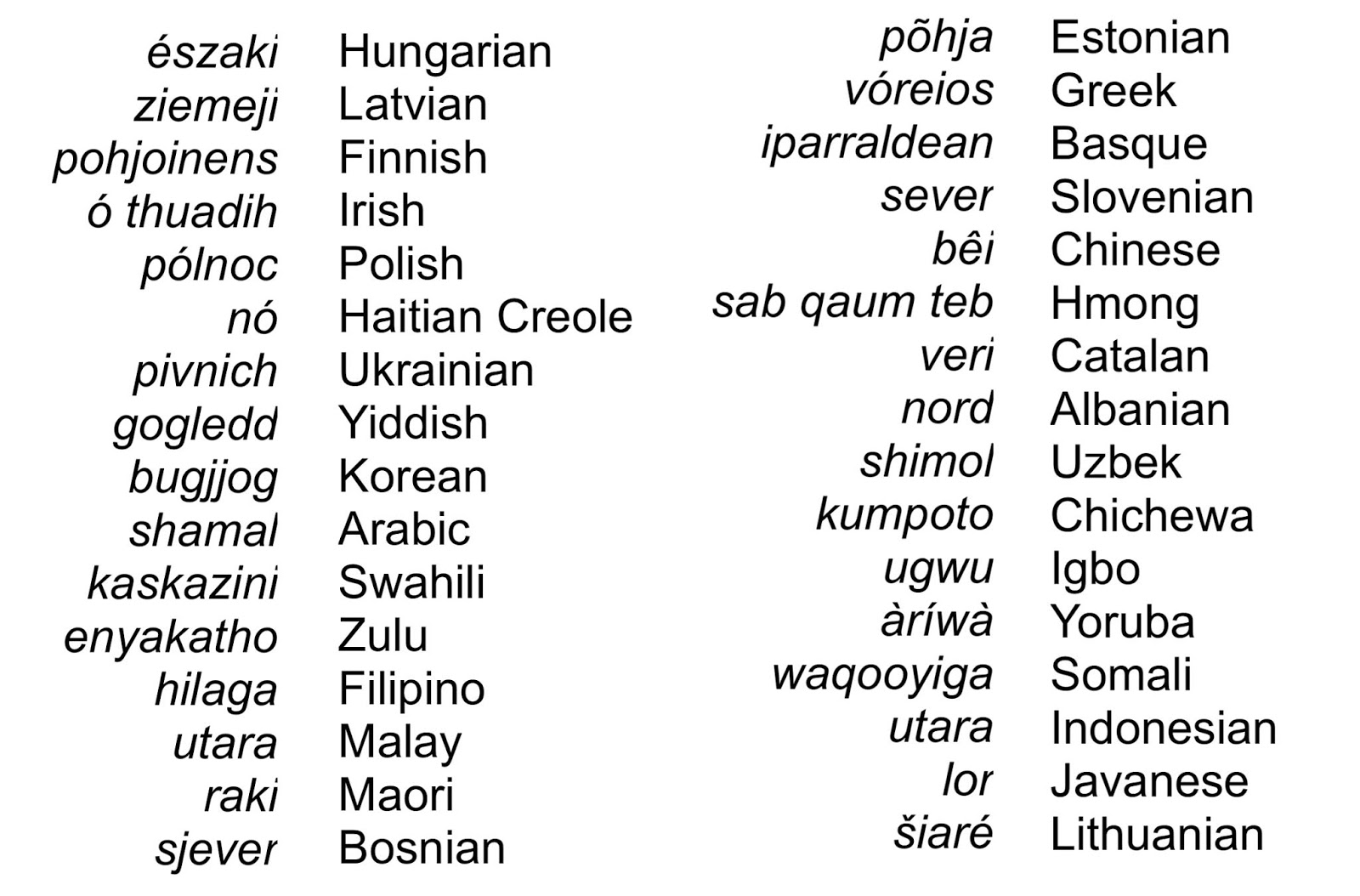
Gardner: “It is both interesting and important to note that Mesoamericans were not the only peoples to use left/right rather than specific names for directions.
Response: It might surprise most to know that before the 12th century A.D., the English word “north” was defined as: “the direction that is to your left when you are facing the rising sun: the direction that is the opposite of south,” and referred to as “left hand,” or “on the left hand.” Many of us were we were taught this way as kids, with directions defined as “left” and “right.” In fact, in an old school book, the terminology was: “North: the direction to the left of someone facing east.” This is not just American, but also Hebrew—since they use east as their orientation (like we use north), their word for “south” is “teyman” which means “to the right.”
Gardner: “William J. Hamblin, professor of History at Brigham Young University notes: “The Hebrews, like most Semitic peoples, oriented themselves by facing east, toward the rising sun. Thus east in Hebrew was simply front (qedem), with south as right (yamîn), north as left (śemôl), and west as rear (achôr) or “sea” (yam).”
Response: The way in which ancients were taught or remembered directions is neither new or unique to eastern people. That they face, or orient themselves, to the east, where westerners face, or orient themselves, to the north, is neither important nor decisive in understanding cardinal directions. When most westerners were young, they were taught to face north, with the rising sun on the right and the setting sun on the left. Naturally, behind them was south. Like Hebrews/Jews, who had the Mediterranean Sea to the west (or behind them when facing east), being from Southern California, I had the Pacific Ocean to the west (my left when facing north).
When a Westerner faces North to orient himself, West is on the right hand; When one in the middle East faces East to orient himself, North is on the left hand. It would not matter what words are conveyed to state this, i.e., right hand, right side, right leg, etc.

If we were to restrict the meaning of “West” in the diagram to the left hand for a Westerner, he would automatically interpret the Middle Easterner’s wordage for left from east to north. above, we would say that “West” means “left,” “left hand,” “left side,” “west,” etc. But in English, we generally do not restrict language that way unless we are very narrowly interpreting something. As an example, in the military, you see a forward observer through your glasses on a distant hill in a “no-voice” location. He would raise his left hand, ¾ down, level, ¾ up, straight up. In artillery, each of these movements means a certain thing in bracketing in on a target (a very narrow interpretation).
Gardner: “The Egyptians oriented themselves by facing south, toward the source of the Nile. “One of the terms for ‘south’ [in Egyptian] is also a term for ‘face'; the usual word for ‘north’ is probably related to a word which means the ‘back of the head.'” The word for east is the same as for left, and west is the same word as right.”
Response: This point is taken from William J.Hamblin, in Direction in Hebrew, Egyptian, and Nephite Language, in Re-exploring the Book of Mormon edited by John W. Welch of FARMS. Again, these are strictly Mesoamerican points. Once again, the point should be made that while Easterners looked to the East for their orientation, Westerners look to the North for their orientation, the Egyptians and Chinese looked to the South for their orientation. This orientation is seen in which direction is at the top of their maps, which shows a proclivity toward how they think. It is also important to know and understand that how words originally came into being has almost no meaning on how they are seen, used, and interpreted in later generations.
    Our “north” is from Old English “northr,” Dutch “noord,” and High German “nord.” Chances are, most English-speaking people have never heard of these words. One of the early meanings of “north” was “above” or “overhead,” One of the early definitions of “north” is “to the left of a person facing the rising sun.” It is “0” on a degree compass, can depict a “north wind,” meaning it is not blowing toward the north, but blowing away from the north.
    In fact, you can look up the etymology of just abut any word and it has derived from a meaning or source one didn’t know about; consequently, it had been numerous generations since Nephi had to face east with his back to the sea to determine his directions. The idea of quoting word origination to prove a point of Nephite directions is both silly and meaningless.
Gardner: “It is worth emphasizing that our Book of Mormon is the result of Joseph Smith’s translation. The nature of that translation has been the subject of discussion among faithful scholars, with opinions ranging from Brigham H. Roberts’ declaration that Joseph “had to give expression to those facts and ideas in such language as he could command” to Royal Skousen’s understanding that Joseph Smith precisely read a translation that had already been done and which appeared in some manner when using the interpreters. My own analysis of the available data is more in line with Roberts.
Response: Gardner makes it sound like an either or condition with Joseph Smith’s translation and, interesting enough, but not inconsistent with Mesoamerican theorists, no mention of the role of the Holy Spirit is mentioned. However, let’s take these three points one at a time:
1. Joseph had to give expression to those facts and ideas in such language as he could command. While it is true that Joseph was limited to his knowledge, vocabulary, and expression of his own language, and it is also true that the Lord “speaketh unto men according to their language, unto their understanding” (2 Nephi 31:3), it would be wrong to believe that Joseph had to figure everything out on his own. This is seen in the Lord’s comments to Oliver Cowdery, who was not content to merely serve as Joseph’s scribe—he wanted to translate himself. President Joseph Fielding Smith pointed out that “it seems probable that Oliver Cowdery desired to translate out of curiosity, and the Lord taught him his place by showing him that translating was not the easy thing he had thought it to be.”
    Obviously, translating was not merely an act of sitting back and waiting for the words to come to mind, but required work and effort on the part of the translator. Why did Oliver fail? The Lord assigned Oliver’s failure to translate to the fact that he did not translate according to that which he desired of the Lord. Oliver had to learn that translating as Joseph Smith was doing was by the gift and power of God. Evidently, Oliver had received sufficient instruction, but instead went his own way, using his own wisdom. He was therefore stopped from translating. As the Lord told him: “You have not understood; you have supposed that I would give it unto you, when you took no thought save it was to ask me” (D&C 9:7). The Lord then went on to tell Oliver, “You must study it out in your mind; then you must ask me if it be right, and if it is right I will cause that your bosom shall burn within you; therefore, you shall feel that it is right.” (D&C 9:8).
    Thus, it should be understood that Joseph had to put out effort, had to study it out in his mind, then see if it was right, and if so, he then read it off to his scribe, but if it was not correct, the wordage did not disappear and Joseph had to work at it again.
(See the next post, “The Mystifying Rationale of Mesoamerican Directions – Part XVI,” and the continuation of Gardner’s rationale of the Mesoamerianists’ skewed Land of Promise, and the various meanings of words that Joseph Smith used in the translation and their accuracy, and with Royal Skousen’s comments)

Sunday, September 29, 2019

The Mystifying Rationale of Mesoamerican Directions – Part XIV

Continuing with Brant A. Gardner’s rationale of John L. Sorenson’s skewed Land of Promise, and Gardner’s idea that the various meanings of words in foreign cultures, and that the Maya had no word for “north” and only a vague concept of it in a “down slope” manner (please read the previous post before reading this one), we continue here in the midst of this discussion.
As an example, according to long-time expert on the Maya, anthropologist and linguist, Richard Luxton, Ph.D, (left), , states: “The short stint in the Peni Juarez that offered a springboard into the Maya world via an old shaman who was incarcerated there and showed an interest in the Bishop Diego Landa's book on the hieroglyphs. The old shaman perused the book and discussed the various interpretations of the glyphs by Landa, and how they dove-tailed with the oral tradition that had been passed down through the generations. The journey continued with Don Pablo Canche and others and shared in his easy reading travelogue styled book, which was translated into Spanish and titled "Sueño del camino Maya: El chamanismo ilustrado anthropology or linguistics." The shaman, called h-menob, was delighted to learn the English word was “Shaman,” which he repeated enjoying the rich Maya sound of the word, like xaman, the Maya word for north where shamanism originated” (Luxton, The Mystery of the Maya Hieroglyphs: The Vision of an Ancient Tradition, HarperCollins, New York, 1982).
Then, too, there is Aluna Jo Yaxkin, author, spiritual life coach, sacred site guide, alternative historian, ordained minister and modern mystic of the Maya, stated: “The Maya word for north is Xaman. It is pronounced ”chaman” and clearly points out a linguistic connection with the native American word “Shaman.” She claims that in Maya Tradition many Shamans are born within the influence of the northern suns. Especially powerful is the sun of Ix.”
Maya Jaguar Priest presides over a pantheon of Jaguar deities

In fact, those “born with the influence of this sun are the Jaguar priest (on stela above) and their words are considered holy and absolute truth.” In addition, Yaxkin adds, “The five sacred suns of the North hold a common theme of inward refinement and the use of the mental facilities, and named Ik, Cimi, Oc, Ix and Etznab and are represented by the color white. North can be a direction of cold and ice and symbolizes the turning inward of life. In some cases it can represent danger and difficulty” (Yaxkin, The Sacred Maya Suns of the North, November, 1994
Regarding the Maya pantheon, Joshua J Mark (left), in The Maya Pantheon: The Many Gods of the Maya, (2012), Xamaniqinqu is the patron god of merchants and travelers, god of the north and the northern energies, and brother to Nohochacyum, Yantho, Usukun, and Uyitzin. He is also known as Xaman Ek: the North God.
    Yet, despite this Gardner goes on to continue with there being no word for “north” in the Maya lanauge.
Gardner: “There was no “north” in the Mesoamerican system–only a spatial relationship to that side of the sun’s path. That is why the vocabulary varies so greatly. It wasn’t that Mesoamericans didn’t know where north was, they conceived it entirely differently. It existed only as a quadrant on the right or left of the sun’s path—where some Mesoamerican cultures called it “right” and some “left.
Response: We covered this in the last post, showing the Maya do have a word for “north” and it means “north” in the same spatial sense our “north” means “north.” While this is not accepted by all Maya glyph experts, it is accepted by many and who is to say one expert is right and another wrong. Since the word has been defined as “north” in the normal sense, it seems to make sense that the Maya had an understanding of north like everyone else.
As an example, John Mamoru Watanabe (left), who received his PhD from Harvard, works in the area of ethnic identity and conflict, religion, and cosmology among Maya peoples of Guatemala and Mexico. Among several other works has written “The Thinking of Mam Speakers,” a language of a unified Maya Indian group of half a million people in western Guatemala for the past 2600 years, the language being after K’iche’ (Quiché), in which we find that “the east is where, as well as when, the sun comes in; west is where and when the sun goes out, and among the Quiche, the Mam, and other Maya groups, the directions north and south are also given by referring to the sun’s right and left sides from the point of view of the sun’s emergence on the eastern horizon” (Watanabe, In the World of the Sun: A Cognitive Model of Mayan Cosmology, Man, Vol.18, No.4, Royal Anthropological Institute of Great Britain and Ireland, December 1983).
This sounds pretty much like a standard description of the cardinal directions that we know.
    As Hopkins and Josserand of Florida State University have stated: “The words and hieroglyphs used by the Classic Maya, the Colonial Maya, and the modern Maya for the “four directions” have been a subject of interest for a long time. Sixteenth-century sources provided the words used by the Yucatec Maya for the directions.
    The terms were East: lik’inor lak’in; North: xaman; West: chik’in; and South: nohol. These are still the terms used by Mayas of the Yucatecan branch of the Mayan family,” according to Martínez Hernández, Book of the Jaguar Priest of Mani, 1909, quoted in Handbook of Middle American Indians, Volume 6: Social Anthropology by Manning Nash (2014), former Professor of Anthropology at the Center for Study of Economic Development and Cultural Change, University of Chicago.
    Martínez Hernández in a 1929 work defined “lak’in” as “east,” “lik’in” as “east coast,” and “lik’in tan” as “thing which is toward the east, toward where the sun rises.” Conversely, “chik’in” is “west, where the Sun sets.” And in the Diccionario Maya Cordemex (Barrera Vasquez, et al, 1980), which is a huge Maya dictionary (like the Oxford English Dictionary) that lists: “lakin” as the older form of the modern Yucatex word for east, “likin.”
The Classic Maya hieroglyphs that represent the “four directions” in Rio Azul Tomb 12 (drawing by David Stuart): 1-North (the Moon); 2-East (Day or Sun); 3-South (Venus); and 4-West (Night)

J. Eric S. Thompson, in Maya Hieroglyphic Writing: An Introduction, (1960) his mid-twentieth century Maya Hieroglyphic Writing: An Introduction, J. Eric S. Thompson (1960), offered no clear readings for the directional glyphs shown above, since he assigned no 3 phonetic value to the contrasting prefixes on the glyphs for ‘east’ and ‘west’. The main sign was clearly k’in ‘Sun’, however, and he recognized the relationship of the glyphs for East and West to the Colonial Yucatec terms, guessing that East would be read lik’in and West chik’in. He also suggested that the latter term might be derived from chin-k’in ‘lowering of the Sun’. North and South presented even more problems. Thompson offered no explanation for xaman, North, but speculated that nohol, South, might be derived from noh ‘great’, a concept sometimes associated with the right hand, and South is on the right hand when you are facing East.
    The point is, one can read dozens of books, articles and papers about this or that “expert’s” interpretation of the glyphs, but the bottom line is there is no agreement on exact meaning, though all agree that there are basic words for the cardinal directions and that, frankly, there is no agreement in sight of everyone ever being on the same bandwagon on this issue. Yet, the bottom line is that when Mesoamericanists’ claim there is no word for north in the Maya language, that is an outright falsity since these glyphs are all interpreted with comparative words for the cardinal directions. It is the interpretation of meaning that has people puzzled, and though in the simplest form the words are there, so many of the “experts” feel there should be deeper meanings involved. Hence, the ongoing discussion that leaves some with the fodder to claim the words don’t really mean what we think they mean.
    But the fact is, the Maya glyphs or language has words and simple meanings (like western words) of the cardinal direction. They are not words added to the lexicon after the Spanish arrived, and it is clear that they existed in the pre-Classic Period, because the reduced forms were those that were being spelled out in Classic Period hieroglyphic inscriptions, and that the original, unreduced, terms can be postulated for Proto-Mayan, as early as 2000 BC (Hopkins and Josserand, Directions and Partitions in Maya World View: Four Directions Terms and Hieroglyphs (An earlier version of this paper was presented March 24, 2001, in the symposium "Four Corners of the Maya World," 19th Maya Weekend, University Museum, University of Pennsylvania).
(See the next post, “The Mystifying Rationale of Mesoamerican Directions – Part XV,” and the continuation of Gardner’s rationale of the Mesoamericanists’ skewed Land of Promise, and the various meanings of words in foreign cultures, and the origination of words in Hebrew and their effect on the Nephites)

Saturday, September 28, 2019

The Mystifying Rationale of Mesoamerican Directions – Part XIII

Continuing with Brant A. Gardner’s rationale of John L. Sorenson’s skewed Land of Promise, and Gardner’s idea that the various meanings of words in foreign cultures, and that the Maya had no word for “north” and only a vague concept of it in a “down slope” manner.
Gardner: “The solution seems to be, as Karen Bassie has argued, that ‘east’ and ‘west’ are not directions at all, but are broad quadrants of the sky centered on, but not limited to, the cardinal directions ‘east’ and ‘west’. ‘East’ is the entire section of the horizon where the sun rises during the year, from solstice to solstice and back again.”
The tropics and Artic Circles, showing the Solstices range from the Tropic of Cancer to the Tropic of Capricorn

Response: So this will be clear, solstices do not cover the full 90º of the earth, but move from the Tropic of Cancer to the Tropic of Capricorn, or about 60º of the eastern (sunrise) or western (sunset) view. The summer solstice occurs at the moment the earth's tilt toward from the sun is at a maximum. Therefore, on the day of the summer solstice in the northern hemisphere (north of the equator), the sun appears at its highest elevation with a noontime position that changes very little for several days before and after the summer solstice.  The summer solstice occurs when the sun is directly over the Tropic of Cancer, which is located at 23.5° latitude North, and runs through Mexico, the Bahamas, Egypt, Saudi Arabia, India, and southern China.  For every place north of the Tropic of Cancer, the sun is at its highest point in the sky and this is the longest day of the year. The winter solstice marks the shortest day and longest night of the year. In the Northern Hemisphere, it occurs when the sun is directly over the Tropic of Capricorn, which is located at 23.5° south of the equator and runs through Australia, Chile, southern Brazil, and northern South Africa (National Weather Service, National Oceanic and Atmospheric Administration, U.S. Department of Commerce, Silver Spring, MD).
    Thus, to any one person in any one geographical spot, the march of the sun covers only about 60º from summer solstice to winter solstice. With that in mind, a person in the Mesoamerican city of Mexico City (their city of Nephi), would have about 30º swing from right to left when facing east, during summer and back. This is a rather small distance from 180º it is not something that would have confused the Nephites. After all, they came from Jerusalem where the latitudinal line is 17º different (Guatemala City is at 14.6349° latitude north, while Jerusalem is located at 31,7683º latitude north).
    This means that Guatemala City is located at 14.6349° latitude north, while Jerusalem is located at 31,7683º latitude north, and Cuzco, Peru is located at 13.5320º south. All within a reasonable degree difference that would have little bearing on the rising and setting of the sun.
While the sun theoretically illuminates one half of the earth (yellow light) in its march across the sky from Winter Solstice to Summer Solstice, the sun does not appear everywhere on the globe—the movement is about 47º (between winter and summer solstices) and, therefore, “east”—where the sun rises” throughout the year, covers far less than the entire 180º range as Gardner implies 

When seeing both the Summer and Winter Solstice coverage, the actual degrees falls between 116.5º and 163.5º, or between 63.5º and 16.5º, which is a total of 47º of movement out of 180 degrees of visible distance to the human eye. These, then, are not broad quadrants of the sky, but the movement of the sun from Solstice to Solstice, which is both trackable and measureable in spatial terms, thus the “east direction” would not vary much and remain in a “right to left” or “left to right” position of rising, which is why in the north or around the Arctic Circle at certain time of the year it is either long days or long nights—thus even primitive people were able to measure the equinox (middle) point between these Solstices for an exact “east” or “west” point.
    Thus it cannot be said, as Gardner does, that “‘East’ is the entire section of the horizon where the sun rises during the year, from solstice to solstice and back again.” Since “east” is going to be determined as the mid-point between the sun’s movement from Solstice to Solstice, otherwise, planning, harvesting, and numerous other survival activities would not be known and understood and such primitive cultures would never have lasted long on the Earth.
Gardner: “This quadrant is represented in site layout by the E-group complexes found at Uaxactun and elsewhere. ‘West’ is the corresponding quadrant where the sun is observed to set. ‘North’ and ‘south’ are simply the quadrants that lie between these two, that lie ‘at the sides of the sky’, ‘to the right hand’ or ‘to the left’. That is, two defined quadrants imply two others, giving a total of four. The “four corners of the Maya world” are simply the limits of the east-west quadrants, and do not imply four cardinal directions.”
Left: A four-quadrant directional system is not any different than the present compass rose—Quadrant 1 would be Northeast, Quadrant 4 would be Southeast, with due east in between, giving four cardinal points, and four ordinal points of the compass; Right: Cardinal, Ordinal, and second intercardinal points

Response: In this modern compass, the four cardinal (north, south, east and west) take up 90º each when using only four; the intermediate (intercardinal or ordinal) points drop that distance down even more, and the secondary intercardinal points drop it even further to 47º, that is, “east” runs from East-northeast to east-southeast
    Gardner, in his quest to find a way to make the skewed directions of Mesoamerica work, simply ignores the reality of both astronomy and early man’s knowledge of Solstices and the Equinox of that drove all agrarian societies. No early society looked at the sun’s march across the skies and thought the entire breadth of the 47º arch of the sun’s movement was all “east.” They knew, and well understood the idea of the equinox (equal or middle) of this range, and knew that that equinox represented their “east.”
    Since Nephi knew and understood, as well as used correctly in his record this third, or intercardinal point of south-southeast (see above right diagram), there is no reason to believe that the Nephites after him did not know it and understand it. *1 Nephi 16:13) This only shows that if the Maya can truly be shown not to know and understand this point, then any further argument of them being Nephites and Mesoamerica being the Land of Promise is moot and indefensible by Gardner, Sorenson, or anyone else.
Gardner: “Hopkins and Josserand report an interesting example of what happened when an informant was asked to give the word for ‘north’. The Tojolabal speaker (A Mayan language) did not provide a word, but rather a definition: “wa xkilatik ti b’a norte ta wa xkan to b’a surda jk’ab’tik b’a. . [periods as in original] wa xmukxi ja k’ak’u’i (We are looking north when we stand with our right hand toward where the sun goes down.)”
Response: First, to be accurate, the word “Mayan” is not used as an adjective, and in fact, the word Mayan does not exist in the Maya or Spanish languages, nor is it in use by the indigenous Maya. It evidently came into limited use in 1517 as a corruption of an obscure Maya term or phrase. Therefore, it should be “Maya language” above). Second, how can one have a definition without a word that is being defined? Third, if one does not read the footnote (#17) at the end of that statement and look it up, then one is missing the hidden or obscured point that should be clearly understood. The note is this: “The Tojolabal entries are clearly not lexical; the compiler of the dictionary, Carlos Lenkersdorf, is concerned with explaining to Tojolabal speakers the meaning of terms in Spanish (and vice versa) rather than simply listing lexical items.” (Before commenting further, this information is from Nicholas A. Hopkins and J. Kathryn Josserand, “Directions and Partitions in Maya World View,” Foundation for the Advancement of Mesoamerican Studies, Inc. 2011, otherwise known as FARMS, the furthermost and unabashed defender of Mesoamerican Land of Promise models).
Now, as for the note. “Lexical” means the “words or lexicon of a language,” i.e., “of or relating to words or the vocabulary of a language as distinguished from its grammar,” i.e., again, the definition and meaning of words. Consequently, “the word or phrase, whatever it is, for “north” in the Maya language means, or can be defined as “the cardinal direction to the left of east.” Interestingly, that is exactly how our generation learned directions when in grade school. The teacher had the students face north, and then say, “on the right hand is east, behind me is south, and on the left hand is west.” For many years, we had to think of that spatial interpretation to learn directions.
    Even today, to define directions, one first determines a cardinal direction. Living on the West Coast, we knew the Ocean was to the West, therefore, east was opposite, north and south in between, etc. When going to college in Santa Barbara, the viewable ocean was to the south, and we had to adjust our directional thinking. In the military, we learned to use a compass extensively, but when without one, the sun’s rising and setting handled that (of course there are numerous ways with stick, string, etc., to determine directions in the field).
    Now, back to lexical. Gardner uses this, as does Hopkins and Josserand, to show that the Maya did not have a word for “north,” but of course they did—it was simply not part of the lexicon being described, since the author of the dictionary, Carlos Lenkersdorf, was trying to explain to the Maya the Spanish word “norte” (north) in a way the Maya would understand, i.e., saying “We are looking north when we stand with our left hand toward where the sun goes down.”
    While these Mesoamericanists claim the Maya have no word for “north” in their language, numerous Maya hieroglyphics experts claim the Maya word for north is xaman, though it is not universally accepted.
(See the next post, “The Mystifying Rationale of Mesoamerican Directions – Part XII,” and the continuation of Gardner’s rationale of Sorenson’s skewed Land of Promise, and the various meanings of words in foreign cultures, and Gardner’s idea that the Maya had no word for “north” and only a vague concept of it in a “down slope” manner)

Friday, September 27, 2019

The Mystifying Rationale of Mesoamerican Directions – Part XII

Continuing with Brant A. Gardner’s rationale of John L. Sorenson’s skewed Land of Promise, and Gardner’s idea that the Maya alone used a sun rise to sun set and the arc through the sky to the sun’s zenith and on to sunset in the west was someone unique or special among the Maya and, therefore, shows they had a fifth cardinal point of direction, along with our responses.
In addition to the words mentioned in the last post, there are also Polysemy words that, when translating, no single word or phrase covers the entire possible meanings conveyed, and in some cases they can vary according to context. David Moore, a doctoral candidate in Linguistics at the University of Western Australia, an accredited interpreter of the Alyawarr language of Central Australia, works as an interpreter in courts, tribunals and police interviews. He states that the word “kulini” in Western Desert languages has an English translation which cover the senses of “understand,” “hear,” “know,” “think,” “listen,” “believe,” and “obey.” Yet, when trying to show an English word meaning for “kulini,” no single explanation would be accurate (Moore, “Aboriginal Languages and Interpreting in the Northern Territory,” NT Indigenous Law Bulletin, vol.8, iss.12, May/June).
    The point of all of this is that translation is not a simple matter and, in most cases, not something easily checked or verified. A lot is dependent upon the interpretation of ideas and meanings as passed on between the aboriginal person and the translator. If translation is only done from written matter, such as in Mayan, the problems become expanded, for it is a one-sided evaluation, and the pre-disposition, background, understanding, purpose, etc., of the translator becomes involved.
    No doubt this is why Joseph Smith needed the assistance of the Spirit through the Urim and Thummim and seer stone in order to develop the correct translation. The problem is that Mesoamericanists approach Joseph’s translation as they would any secular translation and try to make it mean what they want it to mean, or suggest that the scriptural interpretation is either wrong or not quite correct.
Gardner: “What Pinker didn’t know was that the upslope/downslope spatial orientation was repeated in their concept of world directions. Upslope/downslope are not only the terms the Tzeltal use instead of ‘left /right,’ but are also used instead of ‘south/north.’ The Tzeltal conceive of the East/West axis as the critical direction for orientation. Upslope (left and south) and downslope (right and north) are simply the same terms they would use for anything else that is spatially oriented against the main reference (the sun in the case of the directions, or the human body in the case of the location of the spoon in the cup). They are not terms for “north” or “south”, but simply for spatial orientation against the reference position.”
Response: While this might be of interest to some, especially in the study of a particular people, it has little bearing on the majority of instances in the world where spatial terminology is used, understood, and properly identified. Again, this is like Sorenson’s argument of the Mohave Indians who could travel 100 miles in a day, thus his argument was that the day and a half journey of a Nephite across the narrow neck of land had to be much wider than others thought, giving rise to his 144-mile-wide Isthmus of Tehuantepec as Mormon’s narrow neck of land.Gardner: “David Stuart of the Peabody Museum at Harvard University analyzed two Maya glyphs and argued for their meaning as “right” and “left” by noting their visual associations with other glyphs typically given as “south” and “north.” He concludes: “As students of Maya cosmology have often noted, the sun’s path defines the principal axis of the universe, with its ‘right’ and ‘left’ determining the perpendicular axis that corresponds to our ‘north’ and ‘south.’ In Chamula and other Maya communities, the celestial “sides” are perceived from the sun’s own perspective. This idea is corroborated by a larger study of direction terms in various Mesoamerican languages.”
Response: As mentioned above, the interpreter’s personal viewpoint has a lot to do with how that person sees translation. That the glyphs meant “right” and “left” cannot be shown beyond a doubt, since the interpretation cannot be verified other than by the one making the translation. And the idea that spatial directions to the Maya had to do with the movement of the sun more than ours does today is another point that cannot be verified.
Monument Valley just before sunrise

Gardner: “Nicholas A. Hopkins, visiting instructor at the Centro de Estudios Mayas, Universidad Nacional Autónima de México, and J. Kathryn Josserand, Research Associate, Pre-Columbian Art Research Institute, found a general agreement in vocabulary for east and west that was related to the path of the sun.” 

Response: And this is a surprise? All western thought, directions, compass, etc., is related the rising of the sun in the east and the setting of the sun in the west. How else would one orient himself to his land or the time of day?
    The importance of the arc in the sky is based on the zenith representing noon time, an important factor for early cultures who did not have clocks or watches. In many cultures, early man told time by the movement of the Sun. For those who traveled abroad in ancient times, knowing the winter solstice was paramount since it was the shortest day of the year (in the northern hemisphere), the longest night where warmth was probably harder to achieve in the open, and important to know for survival. As the Crow Canyon Archaeological Center put it, “Archaeoastronomy―the study of how people in the past tracked, recorded, and understood the movement of celestial bodies―is perhaps one of the most exciting and challenging subfields of both archaeology and astronomy.
The Pueblo Indians of the Southwest U.S. used a “horizon calendar,” i.e., picking out a geographical feature on the distant horizon (a pillar, shaped rock, or cliff side, etc. such as in Monument Valley, Utah) that could be used to measure the gradual displacement of the sun through the seasons upon a nearby rock or carving

Evidence of ancient astronomical observation is often subtle and open to interpretation. But in the American Southwest, where ancient architecture and images pecked into stone are extraordinarily well preserved, a compelling case can be made for the Pueblo people’s sophisticated understanding of the heavens. And why would it have been otherwise? The lives of these ancient farmers depended on it!”
    In fact, in their attempts to use the heavens to give their lives order, balance, and predictability, it was not just the Pueblo people, but from very ancient times in Egypt to China to Europe, early agriculturalists around the globe devised ways―some elaborate, some ingenious in their simplicity―to observe, record, and use to their advantage the cyclical movements of celestial bodies. And at the heart of all these cultures the sun rising in the east, reaching its zenith in the sky and then setting in the west was at the core of their directional systems.
Anasazi ruins in the Four Corners area of the Southwest U.S. The Anasazi were the forerunners of the Pueblo, whose archaeological patterns emerged a little before 700 AD
 
Gardner: “They noted: “Terms for ‘north’ and ‘south’ are much more elusive. First, there are far fewer reports of these terms. Second, there are no consistent patterns in the nomenclature. Many languages have no recorded terms for ‘north’ and ‘south’, even when ‘east’ and ‘west’ are noted.”
Response: Isn’t it interesting, while the Maya language seems devoid of much in the way of “north” and “south,” and far more for “west” and “east,” the scriptural record of the book of Mormon show that the Nephites used “north” and “south” with considerable frequency and little of “east” and “west,” which obviously gives rise to the shape of the eland (long and narrow). After a while, one might get to wondering where the match between the Book of Mormon and Mesoamerica really exists.
Gardner: “They concluded: The extreme chaos of terms for ‘north’ and ‘south’ reinforces the idea that these “directions” are almost irrelevant. Directional orientation is based on the movements of the sun, east to west, and the other two “directions” are of lesser importance. How then, do we derive the system of four directions that is recorded in village barrios regional states, and other matters?”
Response: Perhaps by discarding the Mesoamerican model completely. After all, the Nephites were an Eastern culture, which relied on the direction “east” in almost everything they did; and the Nephites were certainly a Hebrew/Jewish culture, which held “east”—toward God—and “west”—movement away from God, of extreme importance. It should seem obvious to the most skeptical linguist and critic of Mormon’s descriptions and Nephite directions that “east” was the cornerstone of their religion and directional system. Even today, those of the Mid-East, including both Jew and Arab, look to the “east” with both reverence, and extreme importance.
Mizrah means “east” in Hebrew and is used when denoting directions. It literally means “the rising of the sun”

In fact, while the Hebrew word qedem (qedmah) means “the front of a place,” and relatively has the meaning of “east,” as in “before time,” “before east,” “eastward,” “ancient time,” and “old past,” the term מִזְרָח mizrah (Misnah) is the Hebrew word for “east” and the direction they face when praying (from the time of the Diaspora), and specifically means “the direction of the rising sun.” One indication of this association with the east is that the origin of all things could have come, does come, and will come from the east!” And it is to the east that all things of importance are located, including the temple and God and the various ancient synagogues.
    According to “United with Israel, The Global Movement for Israel,” a 3-million member grass-roots movement of individuals deeply committed to the success and prosperity of Israel, centered in Bet Shemesh, Israel, “When Jews pray facing east, they are not merely turning to the capital city in the Promised Land of their forefathers. Like a missile that narrows in on its target, the soul of the Jew is programmed to seek out its source–the root of its holiness. Jews first face Israel, then as they reach Israel, Jerusalem, and lastly as they reach Jerusalem, the Western Wall–site of the Holy Temple. Their direction is one of progressive holiness, one that narrows in and targets the highest level of closeness to the Divine Presence. And that’s the secret of Jerusalem – the place where the soul unites with its Creator, the life-line of all humanity. When Jews pray facing east, they are not merely turning to the capital city in the Promised Land of their forefathers.
    “We use north as our major orientation such as in maps which are always oriented to the north. While we use the north as our major direction, the Hebrews used the east and all other directions are oriented to this direction. For example, one of the words for south is teyman from the root yaman meaning "to the right,” i.e., “to the right of east.”
(See the next post, “The Mystifying Rationale of Mesoamerican Directions – Part XIII,” and the continuation of Gardner’s rationale of Sorenson’s skewed Land of Promise, and the various meanings of words in foreign cultures, along with our responses)

Thursday, September 26, 2019

The Mystifying Rationale of Mesoamerican Directions – Part XI

Continuing with Brant A. Gardner’s rationale of John L. Sorenson’s skewed Land of Promise, along with our responses.
Gardner: Steven Pinker, Professor of Psychology at Harvard University, provides some interesting background on this terminological problem. His emphasis was on understanding how the brain encodes meaning rather than anything to do with geography, but the example is informative…Levinson’s group examined Tzeltal, a language spoken in the Chiapas region of Mexico…Tzeltal has no general words for “left” or “right.” The closest it has is terms for the left or right arm or leg, but the terms are rarely used to refer to the left side of an object, table, or room. Instead the Tzeltal speakers describe spatial arrangements relative to the mountain slope that dominates their villages. The spatial vocabulary of Tzeltal includes words that mean “up-the-slope” (which is roughly southward), “down-the-slope” (roughly northward), and “across-the-slope.” These coordinates are used not just when traipsing up and down the mountain but also when on flat terrain or indoors, and even when describing the arrangements of small objects. According to Levinson, Tzeltal speakers say “The spoon is downslope of the teacup,” not “The spoon is on the right of the teacup.”
Response: First, Parker (left) also wrote: “By examining our words, we can learn a lot about who we are.” It is interesting he did not say “what we think, or what guides us, or how we see the world.” Obviously, if one wants to wade through this linguistic work, they might find a lack of relationship to the idea under discussion here. Second, having spent many years training professional people who were visiting or being transferred from one culture in one part of the globe to another culture in another part of the world. As an example, in Afghanistant and all Muslim countries, eat your food, gesture, and wave with your right hand, not your left, which is considered unclean. Though a spatial appendage, it had nothing to do with directions, spatial thinking, or linguistics—it was a hygiene matter and paramount in their thinking and actions. Many Americans who thought our training was ridiculous learned the hard way to avoid things such as using the “left” hand or one of hundreds of other social graces when in country. While crossing your legs in a figure four as Americans tend to do, it is offensive to many foreign countries to show the soul of your foot (cross legs as women do with the soul pointing downward).
Left: Motioning “come here” in most parts of the world; Motioning “come here” in China, Japan, and Peru

Such other areas are like in China, if you clean your plate to finish a meal, the host will be offended, thinking you didn’t get enough food; in Afghanistan and India, if you clean your plate, it will be filled again; but in Kenya and Germany, if you leave a little food on your plate, it suggests you didn’t like the food. Or in Germany, the only food to eat with your fingers and not utensils is bread, any other, including pizza and fries, is offensive. In Vietnam, pointing with one finger is offensive (you must point with your entire hand), and in India, one is expected to refuse a first offer—it will be offered again.
    In Pakistan, arrive about 15 minute after the scheduled start time of a meal and up to one hour after the start of a party; but in Denmark, you are expected to be punctual at all times. In Libya, Slovakia, and Norway, greet a colleague with a handshake, and in Russia, never shake hands or conduct business over a threshold (step all the way in or all the way out). In Vietnam, do not touch someone’s head or shoulder, and do not pass things over a person’s head.
    Almost every culture has its taboos and acceptances that foreigners find important to learn if they are going to conduct business there, or just get along socially. None are directional factors and none deal with cardinal compass directions. Gardner here, as Mesoamericanists often do, is simply clouding the issue and trying to sell us his point of view.
Gardner: “We should not assume that Tzeltal speakers don’t understand right and left. They certainly do. They simply use different terminology to describe those spatial relationships.”
Response: The thing about translating words is an understanding of the meaning of the words to be translated. As an example, we do not know that Reformed Egyptian has words “left” and “right.” They may have words that are used for this, which may be no different than the Tzeltal, or many of the cultures we used to prep people to understand in their long-term in-country assignments. After all, when linguists assign meanings to words of aboriginal cultures, it is not always possible to know the actual “meaning” of words used from a “western” or “English” translation process. 
Take any word among the 88+ different languages and it will have 80 or more different spellings and pronunciations—however, in all cases it will have the same meaning of a directional bearing

At the same time, some words will have slightly different word transfer etymology, yet still project the same meaning. Take the word “boobook” in Australian aboriginal language (which brings us kangaroo and boomerang) can be translated as “owl.” Yet, it is not a correct translation, for the name comes from the two-tone sound a certain owl makes, but not every owl makes the sound. Still, in Australian, using “boobook” for “owl” would be understood. Owl could also be “Goor-goor-da,” “Melin-de-ye,” and “Koor-koo,” equally understood generally as “owl,” unless you are working in taxonomy. Another word in indigenous Australian is “bombora,” which can be translated as “sea waves,”” submerged rock shelf“ or “reef,” or “sand bank.” It can also mean “rapids” in a river, or where the “surf breaks” some distance from shore. However, it is almost solely used in surfing and made popular by “Bombora-The Story of Australian Surfing,” and includes numerous “surfing” slang meanings.
    Or take the Egyptian words for north and south. Literally, the image or character for south is a boat “sailing up river,” and for north is a boat with sail furled, “sailing down river,” based on the narrow strip of habitation along the Nile in ancient times. Yet, they still meant the same thing as our north and south. The same is true of Gardner’s example of the Tzeltal “up” “down” and “across” the slope. Even those words convey other than directions to an unknowing person, they have the same meaning as we have in using north and south and across (east and west). That is, they rely heavily for an absolute frame of reference, on the overall slope of the land, distinguishing an “uphill/downhill” axis oriented from south to north, and an orthogonal “crossways” axis (sunrise-sunset) on the basis of which objects at all distances are located. As a result, when a Tzeltan uses the expression uphill, he means north; if he uses downhill, he means south, and also has reference words lok’ib k’aal for east or sunrise, and malib k’aal for west, or sunset (Penelope Brown, “Time and Space in Tzeltal: Is the Future Uphill?” Frontiers in Psychology, Frontier Media SA, July 9, 2012)
In this, the Tzeltal are no different than almost any other people in expressing understanding—the meaning of words and gestures are basically the same, though the words and gestures are unique to them. After all, Tzeltal, which is also known as Ts'eltal, is closely related to Tzotzil and the two languages form the Tzeltalan branch of the Cholan-Tzaltalan sub-branch of the Ch'ol Mayan languages. In all these languages, certain words mean what other languages mean with their corresponding words, though the words are different. As an example, there are several Mayan languages, such as Achi, Aguacateco, Akatek, Ch’ol, Chorti, Huasteco, Ixil, Kaqchikel, Ki'che', Lacandon, Mam, Q’anjob’al, Q'eqchi', Tojolabal, Tsotsil, Tzeltal, Tz'utujil, Yucatec Maya. Words are not all the same between them, but there are corresponding meanings among their different words.
    According to Widdowson and Howard in Approaches to Aboriginal Education in anada: Searching for Solutions, (2008), another very serious problem, seldom understood, let alone included by the layman in discussing translation, is what is called “back translation.” This occurs when an aboriginal language is translated into, say French or German, and then later, back-translated into English, that is, from aboriginal to French and then from French into English.
    The point is, to say that an aboriginal language has no equivalent word for left or right may well be correct, but such wide-sweeping assertions of reasoning can often be shown to have other answers and meanings.
    A search in one Canadian aboriginal language of the spatial word “left,” does not produce a spatial interpretation or meaning, rather, it is an action: “eskutaski,” meaning something left and not eaten; while “eskutk,” means it was left for someone else to eat. On the other hand, and this is important, the word “right” brings us “iljo’qwa’sik,” meaning “to right itself,” such as a vessel in the water, as well as the spatial “inaqn,” meaning right hand.” Yet, when looking for “left hand,” it gives us the same spatial meaning of “right hand,” “grasp with the right hand,” with no spatial meaning of “left.” The closest spatial meaning is “turns it wrong side out,” for “left” being the “wrong side,” which is quite common in many languages for reasons unassociated with space, but more with right and wrong, good and evil, or acceptable and non-acceptable.
(See the next post, “The Mystifying Rationale of Mesoamerican Directions – Part XII,” and the continuation of Gardner’s rationale of Sorenson’s skewed Land of Promise, and the various meanings of words in other cultures, along with our responses)

Wednesday, September 25, 2019

The Mystifying Rationale of Mesoamerican Directions – Part X

Continuing with Brant A. Gardner’s rationale of John L. Sorenson’s skewed Land of Promise, along with our responses.
In the Maya cosmology the Representation of the Universe with the Sacred tree Yaxche (Ceiba Tree meaning “blue green tree,” or yax cheel cab, “the first tree of the world,” and the axis of the world the center of the cosmos, the place of their origin) and the 4 Bacabs in the corners holding the earth, which stood in the middle of the world and held up the sky

There is always a fifth element of the Sun God, and the tree of life or World Tree growing from the center of the earth and reaching up into the heavens—a great Ceiba Tree that stood at the center of the earth, connecting the terrestrial world to the spirit-world, the long thick vines hanging down from its spreading limbs provided a connection to the heavens for the souls that ascended them. This fast growing tree when young increases 6 ½ to 13 feet per year and can reach 230-feet when fully mature.
    This rainforest tree, which colonizes riverbanks and grows in several rainforest habitats, its trunk is up to 10-feet wide with no lower branches, which are bunched at the top with an umbrella-like canopy. The tree’s seeds are non-edible, but the fruits contain large quantities of cottony kapok fibers which entangle the small seeds and transport them through wind and water. During its flowering period, the ceiba attracts bats and moths to its nectar, with nectar production in excess of 2 gallons per tree per night and an estimated 45 gallon per flowing season.
    To the ancient Maya, the ceiba was the most sacred tree, and according to Maya mythology, it was the symbol of the universe, or sometimes referred to as the home (5th direction). The tree signified a route of communication between the three levels---a nine-layered underworld (Xibalba), a middle world inhabited by humans, and a heavenly upper realm, supported by four Atlantean god, the Bacabs.
    Its roots were said to reach down into the underworld, its trunk represented the middle world where the humans live, and its canopy of branches arched high in the sky symbolized the upper world and the seven to thirteen levels in which the Maya heaven was divided. According to the Maya, the world is a quincunx, consisting of four directional quadrants and a central space corresponding to the fifth direction. Colors associated with the quincunx are red in the east, white in the north, black in the west, yellow in the south, and green in the center (Nicholettq Maestri, “Ceiba pentandra: The Sacred Tree of the Maya: Connecting the Upper, Middle, and Lower Maya Realms,”; Timothy W.  Knowlton and Gabriella Vail, “Hybrid Cosmologies in Mesoamerica: A Reevaluation of the Yax Cheel Cab, a Maya World Tree,” Ethnohistory, vol.57, iss.4, 2010; pp709-739).
The Maya world tree is found on much of its iconography, from stela to codices

The Tree of Life with its roots and branches is a powerful symbol. It connects the earth and the sky and symbolizes strength, wisdom, protection, wealth and beauty. The tree became a symbol of immortality to the Maya since it gave fruit and seeds, which created new trees and new life. To the Aztecs,it was the cosmic Tree of Life, and in both cases was the center of all thought and being. Connecting these three levels was the Axis Mundi, a great and sacred Ceiba Tree, along which both the souls of the dead and the gods could travel. They used this “road” to make their journeys between the levels of the universe, thus, the so-called 5th direction,
    Even today, these grand trees are regularly spared when forests are cut—it is a common event to see lone, isolated Ceiba trees proudly spreading their shady branches high above a pasture or agricultural field, a relic of the great forests that once were there. However, the tree and the god are external to the four corners or four cardinal positions of north, south, east and west.
    Gardner: “While the five-part concept defined the understanding of one’s orientation in the cosmos, the actual directional system appears have been built on only a single “direction,” which was the path of the sun throughout the day and throughout the year. Other spatial relationships were made against that defining axis.
    Response: Mesoamericanists define this information very narrowly. The myths and legends associated with all this is far beyond a spatial fifth directional setting. As an example, Maya beliefs about the ceiba tree include that it is actually their place of origin and the source of the abundance of their resources and of the protection of the gods.  Some Maya believe that their ancestors and gods and other supernatural beings live in the ceiba tree. Generally speaking, the Maya understand themselves to be much more a part of nature than modern man; that they are not so distinct from animals and plants, and that essences of living things are much more fluid. The Maya did not see such strong boundaries between what might be called heaven and earth, or between the supernatural and the natural as does modern man. However, the overall point is that the Maya did not use this fifth point as a literal cardinal compass direction, but of a fifth area of extreme import, again representing the home and the source of their creator god. In this way, it is not much different from man today.
The Fejérváry-Mayer Codex with the first page on the right

In fact, the illustration of a very rare pre-Columbian Codex of Aztec origin known under the names of its last owners, Fejervary-Mayer, and visible today at the World Museum of Liverpool, both the Aztec and Mayan societies had a strong cultural community. The text referral is the first page of the Codex, Which suggests a representation of the compass points  where north and south are reversed compared to the usual wind rose. In fact, the reverse pattern corresponds to the view of the terrestrial wind rose from “underneath”, i.e. as if it was seen from the underground world.
    Thus, the view from below shows four trees, oriented according to the compass points, on the image, a repeated pattern of the Mayan architecture. The trunk of each tree is divided into two lateral branches without pursuing its elevation towards the sky. It illustrates the horizontal deployment of the being's states in the terrestrial world, the world of duality.
    In a representation of the compass points where north and south are reversed from the underworld, compared to the usual directions as seen in the middle world or where man dwells. This is corroborated by the characters listed on the first page of the Codex, with the central character being the “Lord of the four directions,” with the ceiba tree pointing towards south in the underground world and north in the terrestrial world. In the cycle of the compass four points mentioned, north precisely corresponds to the period of regeneration followed by birth at east, life at south and death at west. Like the present western directional rose, the Maya directions were corresponding. Just as the four compass directions radiate from a single point, the center of the terrestrial world, the four trees are horizontal projections of a single vertical Tree also located at the center. It is called the "Great Mother Ceiba" in reference to Mother Earth. This tree plunged into the terrestrial depths, rises to the heavenly heights and goes through all worlds. In our vocabulary today, we would say the Church is the center of our lives, and all progress and accomplishment in living acceptable lives to God begins there.
Left: Maya directional compass rose; Right: Western directional compass rose. The two are no different in meaning and use

Thus, our western compass also has four cardinal compass points: north, south, east and west; as well as a 5th direction and tht is toward God, the Church, and our eternal progression. But, of course, it is not literally a cardinal compass direction—more a figurative direction that guides us along our life’s path. Yet, there is a difference, for the Maya believe that the gods created humans to praise them, and the gods haven't yet gotten humans right: they destroyed the first three versions of us as failures.  The present version, of which we are a part, is also thought not to be so great, and it is expected that in the not so distant future, they will destroy us and replace us with something better—this varies considerably from our Church viewpoint and understanding.
(See the next post, “The Mystifying Rationale of Mesoamerican Directions – Part XI,” and the continuation of Gardner’s rationale of Sorenson’s skewed Land of Promise, and the various meanings of words in foreign cultures, along with our responses)

Tuesday, September 24, 2019

The Mystifying Rationale of Mesoamerican Directions – Part IX

Continuing with Brant A. Gardner’s rationale of John L. Sorenson’s skewed Land of Promise, along with our responses.
Gardner: “Archaeologist Prudence Rice puts it clearly: “Maya quadripartite organization of horizontal space is not strictly based on the four fixed cardinal directions recognized in the modern world. Instead, the divisions seem to invoke the solstice-equinox positions and movements of the sun as it rises on the eastern horizon and sets on the western.”
Response: Consider the claim by Marilyn Masson (left), professor of Mesoamerican archaeology at the University at Albany, whose research focuses on social transformation and political economy of ancient Mesoamerican cultures in Mexico and Belize, who states: “Reconstructing ancient economies must consider urban-rural dependencies and patterns for a more robust view.”
    Her research over the past 23 years has focused on the social transformations and political economy of late Mesoamerican cultures, particularly, the Maya of Yucatan peninsula of Mexico and Belize. She has published articles on ancient Oaxaca and Maya religion, politics, and economy, and is the author/editor of three books: In the Realm of Nachan Kan (2000, Univ. of Colorado Press), Ancient Civilizations of Mesoamerica (2002, with Michael E. Smith, Blackwell Press), and Ancient Maya Political Economies (2002, with David A. Freidel, Altamira Press). Currently she is co-director of a research project at Mayapan, the largest political capital of the Maya world during the Postclassic Period.
    She has worked at sites in Belize, Mayapan, Colha, Kichpanha, K'axob, and also in Oaxaca. Her efforts involved the “document and comparison of rural economies to urban ones, and to adopt a regional, rather than site-level approach, which is continuing in forthcoming years” (Marilyn A. Masson, “Review,” University at Albany, New York, paper published by Cambridge University Press: 20 January 2017).
    This Obviously, suggests that the ancient Maya, both the Lowland Maya and the Highland Maya, are seen quite differently by different “experts” on the Maya, and Gardner or others cannot claim that one view is the only accepted view regarding the Maya.
    To this, Prudence Rice, formerly of Southern Illinois University and head of the Anthropology Department, as well as editor of Maya Ceramics: Papers from the 1985 Maya Ceramic Conference in England has asserted that neither the model of two giant "superpowers" nor that which postulates scores of small, weakly independent polities fits the accumulating body of material and cultural evidence.” Rice actually builds a new model of Classic lowland Maya (AD 179-948) political organization and political geography. Using the method of direct historical analogy, she integrates ethnohistoric and ethnographic knowledge of the Colonial-period and modern Maya with archaeological, epigraphic, and iconographic data from the ancient Maya.
    On this basis of cultural continuity, she constructs a convincing case that “the fundamental ordering principles of Classic Maya geopolitical organization where the calendar (specifically a 256-year cycle of time known as the may) and the concept of quadripartition, or the division of the cosmos into four cardinal directions” (Prudence M. Rice, Maya Political Science: Time, Astronomy, and the Cosmos, University of Texas Press, Austin, 2004; Rice, Maya Political Science, 2013).
The view from Home, showing four directions from the center of wherever the person or object is located

Obviously again, not all Mayanists agree on this point of either the calendar or a 5th direction, though all agree that there were four cardinal directions: East, South, West and North. At the same time, the Maya associated birth and death with the rising and setting of the sun, in association with the sun god. That is, the rising sun is the personification of the sun or Sun God as it proceeds on its journey from east to west, and referred to as k’in (east lak’in) meaning birth and the color red (chak), while West (chik’in, ochk’in) was associated with sunset or death and the color black (ek’). At the same time, zaman (north) was associated with ”up”, and though she wants to relate this to the rising of the sun at zenith, the term north and up has been a part of western cardinal directions for centuries. As for south, it was associated with “down” the Underworld, and its journey back to the east through the Underworld.
    Of course, these are figurative ideas of an ignorant, unknowledgeable society, but not literal directions or any type of change in directions. The rest of Rice’s descriptions fall more into the area of superstition and early man’s way of thinking (The original Inca came out of Lake Titicaca, etc.) and not a directional aspect as Gardner claims.
    Gardner: “Although the plausible origin of this conception is the travel of the sun along the horizon, Mesoamerican systems regularized their depictions (and therefore their perceptions) into a quadripartite system surrounding the center. The world was depicted as a square with lines drawn from corner to corner. The Codex Mendoza shows the Aztec capital city at the center of the world.”
    Response: This is little different than the Inca Empire who considered their home, Cuzco (Qosqo), their ancient capital (Tahuantinsuyo), as the center of the world—in fact they called it the “Navel of the World,” based on the Four regions Empire over which their authority extended. To try and build this into a fifth cardinal point in Mesoamerica is a little beyond the pale.
Map of Aztec and Mayan lands in Mesoamerica. Obviously, the Aztec were in central to southern Mexico and the Maya were in the Yucatan, Belize and highlands of Guatemala

This overall concept is part of the Aztec Mythology Creation Story, in which the original meanings of the symbols were different in numerous aspects. The eagle was a representation of the sun god Huitzilopochtli, who was very important, as the Aztecs referred to themselves as the People of the Sun. The cactus (Opuntia ficus-indica), full of its fruits, called "tenochtli" in Nahuatl, represent the island of Tenochtitlan, upon which the Aztec civilization was founded. To the Aztec people, the snake represented wisdom, and it had strong connotations with the god Quetzalcoatl.
    However, in this early depiction, there is no snake being devoured and was not part of the original legend. In fact, to the Aztecs, the typical scene depicting an eagle overpowering a snake would be considered wrong. According to the original legend, The Aztecs were wandering throughout Mexico in search of a divine sign that would indicate the precise spot upon which they were to build their capital. Their god "Huitzilopochtli" had commanded them to find an eagle devouring a snake (the story is that it is eating something, it can be birds, a snake or a lizard) perched atop a cactus that grew on a rock submerged in a lake. After two hundred years of wandering, they found the promised sign on a small island in the swampy Lake Texcoco. It was there they founded their new capital, "Tenochtitlan." In fact, there is no mention of the four quarters of the quadripartite system surrounding the center.
Gardner: “Tenochtitlan, indicated by the eagle on the cactus (the symbol for Tenochtitlan), sits at the center of the crossed lines that extend from each corner of the cosmos to the opposite corner. While the five-part concept defined the understanding of one’s orientation in the cosmos, the actual directional system appears have been built on only a single “direction,” which was the path of the sun throughout the day and throughout the year. Other spatial relationships were made against that defining axis.” 
The eagle on a cactus sybolizes a prophecy that they were about to find their fated destination, Tenochtitlan, the name for what is now Mexico City, though the original did not have a snake in it. About two decades after Spanish colonization this painting like this was created for the purposes of sending it to the King of Spain

Response: This does not seem to match any of the information garnered from the direction system of the Maya. As an example, according to Prudence Rice’s Maya Political Science, time Astronomy, and the Cosmos, the Maya had the four rains: “East-red and good rains;” “North-white and good rains;” “West-black and poor rains;” “South-yellow and poor rains.” They had four doors associated with the founding of a city, and once the place had been ritually validated, a fence was erected with four doors, north, south, east and west. Even the legend of the Maker, Modeler, Mother-Father of Life dealt with the four cardinal directions of four-fold siding, four-fold cornering, measuring, four-fold staking, having the cord, stretching the cord in the sky, on the earth, the four sides, the four corners.”
(See the next post, “The Mystifying Rationale of Mesoamerican Directions – Part X,” and the continuation of Gardner’s rationale of Sorenson’s skewed Land of Promise, along with our responses)