Thursday, March 31, 2016

Pachacamac: The City of Zarahemla – Part III

Continuing from the previous post regarding where the Mulekites settled and Mosiah found them along the cost near Lima, Peru, and the customs and beliefs that survived over time.  
In 1903, Max Uhle, published writings on the ancient ruin outside Lima called Pachacamac, in the University of Pennsylvania Publications Folio, Philadelphia, in which he wrote:
Pachacamac, which means “Creator God,” was a famous religious center in ancient Peru, comparable to the Egyptian Thebes or the Mohammedan Mecca. According to Estes, it originally contained a shrine of the "creator " god, Pachacamac, to which flocked pilgrims coming from all parts of Peru, three hundred leagues or more,” and later, after conquest of the place by the Peruvians of the highlands, it also had a famous Temple of the Sun.
Situated about 20-miles southeast of the Lima city center, the archaeological complex of Pachacamac is a pre-Columbian citadel made up of numerous adobe and stone palaces and temple pyramids
    But Pachacamac was more than a religious center that drew pilgrimages, it was at the same time, as Uhle added, “a political center, the seat of a leader who ruled over the populous valleys of Lurin, Rimac, Chancay, Huacho, Supe, and Huanan, according to Garcilasso, with Its decline dating from the year of the entrance of the Spaniards in 1533 and the destruction by them of the venerated statue of the principal deity.
    This sounds very much like the governing of Zarahemla, where it would have been the governing body of the entire Land of Zarahemla, which included a swath of land from the West Sea to the East Sea and from the narrow strip of wilderness in the south to almost the Bountiful border in the north, and would have been seen as the seat of the national government of the Nephites and controlling at least the entire Land Southward north of the lands of Nephi and Lehi.
    In the early fifties of the sixteenth century the Augustinian monks transferred the town to the valley.” According to Fray Antonio de la Calancha, by the seventeenth century Pachacamac was already a desolate pile of ruins, forgotten, and no longer a center of anything.
Julio C. Tello, the famed Peruvian archaeologist and considered the “father of Peruvian archaeology,” with his team that conducted several excavations of Pachacamac between 1940 and 1941
    According to Donald A. Prouix, Professor of Anthropology Emeritus, University of Massachusetts, Amherst, who said “Self-billed as a mountain Indian, Julio César Tello was arguably the greatest Native American social scientist of the twentieth century. Because he overcame obscure origins, secured an unprecedented education, and rose to national and international prominence, his life is an inspiring story with broad appeal. Tello’s embrace of anthropology and archaeology provides an enlightening contrast to current conditions in much of the New World, and thus his views have considerable contemporary resonance.”
    Unlike the archaeologists who flock to Mesoamerica, Julio Tello was the most distinguished Native American scholar ever to focus on archaeology. A Quechua speaker born in a small highland village in 1880, Tello did the impossible: he received a medical degree and convinced the Peruvian government to send him to Harvard and European universities to master archaeology and anthropology. He then returned home to shape modern Peruvian archaeology and the institutions through which it was carried out. His work at Pachacamac and elsewhere were the first stratigraphic excavations in Peru, which was part of the era of “real” archaeology in the minds of modern archaeologists.
The front of Pachácamac where it overlooks the ocean over which the Mulekites sailed, and the beach where they would have landed
“The majesty of the Pachacamac palaces, temples, plazas, and the high truncated pyramid convey to us the political, cultural, and religious hierarchy of ancient Pachacámac. In the pre-Inca and Inca periods, it was the most important oracle of the Peruvian coast, where thousands of pilgrims traveled from the farthest corners of ancient Peru.”
    The god Pachacámac, indigenous to the central coast, survived the influence of the Incas and the Spanish. According to Inca mythology, he was the god of fire and the child of the sun, rejuvenator of the world—in short, the creator of the world and all the creatures that inhabit it.
    According to Timothy K. Earle (Department of Anthropology University of Michigan) the coastal area of the Lurin Valley was first settled around to 200 B.C. (“Lurin Valley, Peru: Early Intermediate Period Settlement Development,” American Antiquity, Society for American Archaeology, vol 37 No 4, 1972, pp467-477). This is about the same time that Mosiah reached Zarahemla), and stood for centuries. Long before the Incas established themselves along the coast, while the Chavin were settling and building north of Lima, the foreruners of the Wari culture erected the great Ceremonial Center at Pachacámac: numerous temples with ramps, and the Painted Temple are examples of their religious town planning. When they were destroyed, several small kingdoms and confederations (tribes) were created, and over time two cultures came to dominate the region, the Chancay to the north of Lima and the Ichma (Yschma) culture to the south in the Lurin valley, though they later spread north into the Rimac valley as well.
    However, it should be noted, and you probably won’t hear this suggested elsewhere, that in the scriptural record, there is no mention of a City of Zarahemla in either the Omni or Mosiah accounts. In fact, in Mosiah, the “land of Zarahemla” is mentioned 22 times, the “people of Zarahemla”is mentioned 5 times and being a “descendant of Zarahemla” is mentioned 2 times—but Zarahemla being a city is never mentioned. Not until Alma 2:25 is Zarahemla referred to as a “city” and called the “city of Zarahemla” (Alma 2:26). From that point onward it is referred to as the “city of Zarahemla” 11 times in Alma, and the “land of Zarahemla” 60 times,which should suggest two things:
1: Most of the events in Alma took place in the surrounding land, not in the city; and
2. The Mulekites may not even have lived in a city when Mosiah I discovered them. No city is mentioned or suggersted at any time until Alma 2:25-6 which is 43 years after their discovery by Mosiah I.
The point is, that while the Lurin Valley was inhabited from 200 B.C., according to discovered archaeological findings, no buildings were constructed until about 400 years later. Assuming Mulek landed around 600 B.C., and Mosiah discovered them 400 years later, around 200 B.C., then the time frame correlates, and obviously would be off a few hundred years from dates since carbon-14 dating is not accurate to that degree as we have pointed out in these pages in numerous articles, as well as in our book Scientific Fallacies & Other Myths.
(See the next post, “Pachacamac: The City of Zarahemla – Part IV,” for more information on where the Mulekites settled and Mosiah found them along the cost near Lima, Peru)

Wednesday, March 30, 2016

Pachacamac: The City of Zarahemla – Part II

Continuing from the previous post regarding where the Mulekites settled and Mosiah found them along the cost near Lima, Peru. 
   In the last post, we ended where Mosiah’s possible route from the City of Nephi to the City of Zarahemla might have taken him as the Lord guided Mosiah and those who would go with him down through the mountains and to the lower level valley of Zarahemla.
The ruins of Pachacasmac, the City of Zarahemla. Note the large walls (yellow arrow) around the city (Helaman 1:21; 16:1) upon which Samuel the Lamanite stood to preach to the Nephites
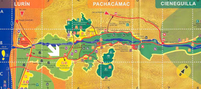
    The City of Zarahemla, or Pachacamac, was located about 25 miles south of Lima and a little east since the curvature of the coast cuts inward toward the east from Callao, lying along the banks of the Lurin River within the narrow Lurin Valley. Today, the Pan American highway runs between the site and the coast.
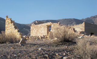
(Top) One of the large structures in the vast Pachacamac complex, overlooking the sea. (Bottom) One of the many streets within the city complex
    Obviously, during the time of Mosiah and his leading the more righteous Nephites who would go with him out of the City and area of Nephi, there were no roads between the City of Nephi and the City of Zarahemla. At this time, the Nephites had not even known there were people living north of them until Mosiah traveled there when fleeing from the city of Nephi. Nor were there roads leading back to the Land of Nephi when Zeniff took his people back to reclaim the City of Nephi, nor any roads for Limhi or Alma to follow from that area in their escapes to Zarahemla later on (this lack of roads caused Limhi's 43-man expedtion to find Zarahemla and Ammon and his party trying to find the City of Nephi to become lost in the wilderness).
    There were, of course, roads built around the City of Nephi, connecting Shilom and Shemlon and down to Tiahuanaco south of Lake Titicaca during the 200 years prior to Mosiah leaving Nephi to discover Zarahemla. In fact, they had a main road from the City of Nephi down through the LaRaya Pass and into the Titicaca basin.
The City of Zarahemla where it is set back from the Pacific Ocean on a promontory hill about 250-feet above sea level. The view from this temple site was breath-taking, especially from the higher terraces 
    As Mosiah and the escaping Nephites passed through the last of the hills coming down out of the mountain passes, the heat of the day across the low-land area where the desert is a furnace struck them, followed by a slight breeze coming from the distant sea to the West. As they traveled westward and neared the coast, they saw a settlement atop a rise overlooking the sea. It became almost immediately obvious that the city and surrounding area of houses and streets that it “contained a numerous people." Upon encountering them, the Nephites quickly realized that these people spoke a language they could not understand.
    Mosiah caused that they should be taught in his language,” and after they were taught their leader, a man named Zarahemla, gave a genealogy of his fathers, according to his memory, which were recorded on the large plates (Omni 1:18). Mosiahdiscovered that the people of Zarahemla came out from Jerusalem at the time that Zedekiah, king of Judah, was carried away captive into Babylon” (Omni 1:15), they had journeyed in the wilderness and were brought by the hand of the Lord across the great waters into the land where Mosiah discovered them and “they had dwelt there from that time forth” (Omni 1:16), and that they “had many wars” among themselves “and serious contentions and had fallen by the sword from time to time” and also that they “had brought not records with them and denied the being of their Creator” (Omni 1:17).
Pachacamac was built with stones and mud brick, the latter is mostly disintegrated by now, but the stones remain almost perfectly in place
The enormous 210-acre, four huge truncated temple site, along with a dozen smaller temples, in the overall 600 hectares (2.3 square miles) of complex, is very impressive. Its stone walls that served as the base for the fantastic adobe structures of great mud-brick stepped pyramidal ramped temples, dwellings, remains of frescoes decorating the adobe walls and other interesting archaeological constructions built by different peoples over time, including vast cemeteries said to hold between 60,000 and 80,000 dead. It was the oldest religious center of indigenous people at the Peruvian coast in pre-Hispanic dating man centuries before the Inca.
    It is interesting that this overall complex, like Sacsahuaman, sits behind a zig-zag structure providing the main access to the compound.
Pacha Kamaq (Pachacamac) was the name of the ancient Peruvian Creator God, or supreme God, creator of the world
    The word “Pachacamac,” according to the chronocles of Garcilaso, Velasco, and Ulloa, or more accurately Pacha (“World”) Kamaq (“to Animate” or “Make”), literally translated means “Earth Maker,” or “World Creator,” “Creator of the World.” In a looser translation, it also means: “The one who animates/generates the world,” that is, "the Great God of Creation." 
    To those who created the city of Pachacamac and lived there originally, Pacha Kamaq was the most powerful God of Heaven and Earth, with the single exception of Inti, Pacha Kamaq’s father, and who created the first man and woman. It is interesting that he was, according to Wilhelm Frederick Griewe, considered invisible and, therefore, was never represented in art (History of South America, Central Publishing, Cleveland, 1913, p84).
    It is also interesting that monotheism existed in Peru throughout its history, even as late as the Inca period. While many cultures had inferior gods, each had one supreme god, and with the Inca it was Viroccha, while much earlier it was Pacha Kamaq who created the world and later sent the deluge to punish the disobedient. However, over time, other gods were considered important as well, and eventually cultures had gods for every possible need, and the knowledge of one god had grown dim and dark, long before the Inca came to power.
    However, before the Inca, Pachacamac was the most important religious center of Peru, and certainly the most important along the coast, already having become a major point of pilgrimages. Through the years and centuries, the pattern of intense pilgrimages extended far beyond the geographical boundaries of the Lurin Valley attracting scores of devotees from the central Andes that came here to consult the shrine’s revered oracle. It is interesting that the records from chroniclers show that the ancient Pacha Kamaq priests acted quite a bit like the Jewish High Priests in regard to the temple with restrictions of activities, isolated areas, and special relics (like the Ark of the Covenant, etc.) and places of special activities (like the holy of holies) and were forbidden to do certain things. One can easily see a form of worship handed down from the pre-Christ era of the Nephites living the Law of Moses.
    In 1533, chronicler Miguel de Estete reports that Pachacamac was the destination of pilgrims coming from places as far away as Tacamez on the Ecuadorian coast, who carried gold, silver and clothes offerings.
    After the Inca conquest of the coast, they took the deeply rooted worship of Pacha Kamaq directly into their Pantheon of gods, but to them, their supreme god Viracocha was more powerful. Over time, Pacha Kamaq became the God of “fire and earthquakes,” because of the vast number of volcanoes and earthquakes that strike this land.
Today’s ruins of Zarahemla, one of the largest overall sacred centers in all of the Andes of South America, mirroring its scriptural record as being the capital of the Nephite Nation and the center of most religious activity throughout the last nearly 800 years of Nephite history
    Less than a hundred years after the Inca took over Pachacamac, however, the great monumental center met its demise. The Spanish conquistador Francisco Pizarro arrived in Peru in 1532 and took the Inca ruler Atahualpa prisoner. Pizarro soon heard about the riches at Pachacamac and in 1533 sent an expedition led by his brother, Hernando, to sack the site and the surrounding area. The Spanish conquerors made off with large amounts of silver and gold and destroyed the idol that served as oracle for the pilgrimage center. Pachacamac never recovered its former importance and within time faded away.
(See the next post, “Pachacamac: The City of Zarahemla – Part III,” for more information on where the Mulekites settled and Mosiah found them along the cost near Lima, Peru)

Tuesday, March 29, 2016

Pachacamac: The City of Zarahemla – Part I

After the death of Nephi in 544 B.C., the Nephites began to expand and grow into a sizable population, while the Lamanites deteriorated into a “wild and ferocious and a bloodthirsty people full of idolatry and filthiness; feeding upon beasts of prey; dwelling in tents and wandering about in the wilderness with a short skin girdle about their loins and their heads shaven” (Enos 1:20). 
    Even in Nephi’s time, despite their leaving Laman, Lemuel and the sons of Ishmael in the land of their First Inheritance where they landed and settled, the crops planted, and whatever improvements they had achieved that first year or so, the Lamanites followed them northward and discovered their settlement area, attacking them on numerous occasions, as Nephi defended his people (Jacob 1:10).
Almost immediately, however, the people “under the reign of the second king, began to grow hard in their hearts and indulged themselves somewhat in wicked practices, such as like unto David of old desiring many wives and concubines, and also Solomon, his son” (Jacob 1:15). By the time of Enos, Jacob’s son, “the people of Nephi did till the land, and raise all manner of grain, and of fruit, and flocks of herds, and flocks of all manner of cattle of every kind, and goats, and wild goats, and also many horses” (Enos 1:21), and there were many wars with the Lamanites (Enos 1:24).
    By the time of Jarom, Jacob’s grandson, in 400 B.C., the Nephites had “spread upon the face of the land, and became exceedingly rich in gold, and in silver, and in precious things, and in fine workmanship of wood, in buildings, and in machinery, and also in iron and copper, and brass and steel, making all manner of tools of every kind to till the ground, and weapons of war” (Jarom 1:8).
    By this time, the ancient city of Nephi, according to Captain Hernando de Soto in 1533, was protected in a hollow at the northern end of the valley, with an enormous stone fortress, a structure so immense that at first sight de Soto and his companion doubted that any army could breach it. The hills were bare of sward (short grass), no trees except the stunted molle (pepper tree) grew there. The city was laid out in large blocks or squares with straight and narrow, paved streets. It had large plazas, public baths, a house of learning, and factories where the women spun and wove cloth of great beauty. The smaller buildings were painted yellow and red, the larger ones of enormous, beautifully laid stonework.
Like the Temple of Solomon in Jerusalem, where the setting sun reflected on the cream-colored limestone facade of both ancient and modern structures, which gives them a golden hue, giving rise to the term “Jerusalem of Gold,” which is the unofficial national anthem of Israel and was sung by Israel Defense Forces on Jun 7, 1967, after paratroopers wrested eastern Jerusalem and the Old City from the Jordanians during the Six-Day War (Yaacov Arkin and Amos Ecker, “Report GSI Dec 2007: Geotechnical and Hydrogeological Concerns in Developing the Infrastructure Around Jerusalem,” The Ministry National Infrastructures, Geological Survey of Israel, Jerusalem, Israel, July 2007)—Cuzco’s temple walls had the same effect of reflection, which at one time as the retreating sun’s rays touched the beaten gold plates that adorned its walls the pyramided Sun Temple, towering over the lower buildings around it, gleamed as if it were cast in metal.
    By 362 B.C. there had been “wars and contentions and dissensions for the space of much of the time” (Jarom 1:13). By 324 B.C., they had “many seasons of peace, and many seasons of serious war and bloodshed” (Omni 1:3). Sometime after 280 B.C., the prophet Amaleki writes that the Lord commanded Mosiah to depart out of the land into the wilderness (Omni 1:12); and “they departed out of the land into the wilderness, as many as would hearken unto the voice of the Lord; and they were led by many preachings and prophesyings. And they were admonished continually by the word of God; and they were led by the power of his arm, through the wilderness, until they came down into the land which is called the land of Zarahemla” (Omni 1:13).
    Evidently, upon leaving the City of Nephi in the area of present day Cuzco, which is located in an Andean valley 11,207 feet above sea level, the Lord led Mosiah through the narrow strip of wilderness, down through the valley and mountain passes to the north and west, between the lakes of Orcococha and Choclococha.
The mountain pass through Huancavelica heading westward
Then northward through the valley pass west of Huancavelica and following the Canyon toward Colpa and turning southwest of there through the Acobambilla District and across to the Lincha District and dropped down the mountains into the Catahuasi District and finally  out of the mountains and onto the lower plain, then crossed the Lurin valley with relative ease northwest to Pachacamac, an overall distance of about 620 miles. Another route would have been to head southwest down through the desert lands to what is present day Nazca, then north to Ica and along the coast toward Pachacamac, a distance of approximately 700 miles.
East end of the Lurin Valley where the (yellow arrow) road from the higher Andes drops down through the Pass and along the rocky ledges
Either way would have given the Lord plenty of time through his many prophets who delivered “many preachings and prophesyings” as they were led through the wilderness to humble the surviving Nephites and mold them into a more righteous people by the time they reached their destination. “And they were admonished continually by the word of God; and they were led by the power of his arm, through the wilderness” (Omni 1:13). By the time these Nephites, who had “hearken[ed] unto the voice of the Lord” and “depart[ed] out of the land with him, into the wilderness” (Omni 1:12) reached Zarahemla, they would have been more reliant on the Lord than when they had been in the City of Nephi.
    While these two routes are merely speculation, there are hardly any others that a large number of people could have traversed from Cuzco to Pachacamac in the days before roads. Passes through and down out of the mountains are limited and the drop in terrain from over 11,000 feet down to 2,000 feet along the foothills and eventually 250-feet at Pachacamac.
    Meanwhile, some centuries earlier, a small band of people made up of palace guards, servants and royal retinue wound their way secretively out of Jerusalem, carrying with them a young prince, probably little more than a baby, who they affectionately referred to by the endearing term “Mulek,” or “Little King.” They escaped the Babylonian hordes laying siege to Jerusalem and traveled south toward the Red Sea, then southeast along its coast as “they journeyed in the wilderness, and were brought by the hand of the Lord across the great waters, into the land where Mosiah discovered them; and they had dwelt there from that time forth” (Omni 1:16).
The narrow Lurin Valley stretching from the Pacific Ocean inland to the east. (White Arrow) Pachacamac is about ½-mile inland from the coast
    The land where Mosiah discovered them, of course, was the land of Zarahemla. As Amelaki stated it: “and they were led by the power of his arm, through the wilderness, until they came down into the land which is called the land of Zarahemla. And they discovered a people, who were called the people of Zarahemla. Now, there was great rejoicing among the people of Zarahemla; and also Zarahemla did rejoice exceedingly” (Omni 1:13-14).
    Anciently, people almost always settled along the coast when first landing, not moving inland for many generations, and then usually up large rivers because of the fresh water source they provided. It would have been extremely unusual for the Mulekites to come into the land called Zarahemla and move inland any distance at all away from the coast. In fact, in this area, the Mulekites would have had direct access to three large fresh-water rivers flowing down out of the mountains and into the sea—the Chillon, Rimac and Lurin rivers.
    To us today, it doesn’t matter much, because there are developed resources almost everywhere—but around 600 B.C., as the first to come into that land, the Mulekites would have remained along the coast and settled there, where rivers flowed out of the mountains, down into the foothills, and to the coast. And this is where Mosiah eventually found them in their land they called Zarahemla.
(See the next post, “Pachacamac: The City of Zarahemla – Part II,” for more information on where the Mulekites settled and Mosiah found them along the cost near Lima, Peru)

Monday, March 28, 2016

Amulon – No Fortress City

There are two particular mountain peaks in the vicinity of the famed Pikchu range (where the highest peaks allow the gods to touch the earth), called Huayna Picchu (in Quechuan “New Peak/Mountain”) and Machu Picchu (“Old Peak/Mountain”), although there is some belief that in this case “macho” should be interpreted as “age,” or “Aged Peak or Mountain” because of its legendary sacred nature. Situated at about 7,700 feet above the Urubamba Valley, lying in a topographical saddle between the two peaks, it is well protected from view below.  
The two cities of Picchu were built along a saddle on adjacent mountain peaks
Today, the stone-built hanging city rests in an almost perfect state of preservation atop the verdue-crowned mountain amidst the tangled Montana east of Cuzco past the fortress of Pisac. Below is the Urubamba gorge through which the Urubamba River flows, one of the myriad of headwaters of the amazon that over the centuries has cut through the heartland of this Vilcabamba Range.
    In seeing Machu Picchu from the adjacent peak of Hyayna Picchu, which is reached by an unusual series of steps cut into the solid rock up the mountain for about a thousand feet, it is obvious that Machu Picchu could not have been an inaccessible fortress for a determined enemy who could have found its conquest no great problem. It’s major defensive drawback is its fresh water supply is in the canyon gorge 2000 feet below. Anciently, the site had a three-inch flume used to bring water down from its higher mountain sources, but the size would not have supplied more than a hundred people—which would have sufficed the priests and their wives and about twice their number of children during the dry season.
    According to Victor W. Von Hagen, Machu Picchu was not the “Lost City of the Incas” as it has been called, that Hiram Bingham claimed was the fortress of Vilcabamba where thousands of fierce Inca warriors had for years eluded the Spanish and forged a new empire (Highway of the Sun, Duell, Sloan and Pearce, New York, 1955, pp110-111).
    As late as 1955 when visited by Von Hagen the area north and beyond Machu Picchu, and immense empty land in a remote, wild region of cold high uplands and hot tropical valleys known as the Vilcabamba where steep mountains of extreme relief that served as a jungle border, was still considered “The vast Geographical Unknown, covered with mountains, foliage and clouds."
    This steep mountainous region of extreme relief that served as a jungle border with altitudes varying from tropical river bottom canyons below 6560 feet to mountain heights on up to almost 19,685 feet, where a thick cloud forest vegetation covers much of the area up to around 13,123 feet.  
Even today it is considered one of the most mysterious places on Earth—located on the spine of a jungle cloaked granite peak towering some 2000 feet above the entrenched meandering of a roaring river below, it is frequently shrouded in misty clouds pierced by the powerful equatorial sun. Constructed from precisely sculptured granite blocks carefully joined with the projecting exposed stone of the surrounding mountain without mortar, and so precisely cut and wedged so closely together, that a credit card cannot be inserted between them, much like the construction of Sacsahuaman and the older buildings of Cuzco. However, the small houses that are joined together like a large ground-level apartment complex, is far less accomplished and made of smaller, rounded rocks with far less expertise in their construction, though still impressive in their overall design and purpose.
    It is interesting that in all the ancient Peruvian buildings where no mortar was used and the stones cut and fitted so precisely together, it is claimed that when an earthquake occurs, the stones are said to “dance”—they bounce through the tremors and then fall back into place. Without this building method, many of the best known buildings would have collapsed long ago.
    The point being, Machu Picchu, though called a Citadel today, was never built to be a fortress, it has not defensive walls, though heavily terraced, and its main buildings are not walled. There are no ditches, no ramparts, no towers, nothing at all that would be considered a citadel or fortress in the true sense of the word. It is, however, built high on a peak, but as indicated earlier, never could have withstood any type of siege, or even an attack with much effect.
    Its main reason for being where it is seems to be for remaining unseen in an out-of-the-way, hard-to-get-to area. A perfect fit for the City of Amulon. The apartment-like complex of houses, built by different hands, it would seem, than the rest of the stonework structures, or at least for a different purpose with "hurry" an apparent requisite, seems to bear testament that they were more hurriedly built, and done so strictly for a place to house several independent families.
Even today there are areas all over Andean Peru that are completely isolated because of the terrain where there are no settlements, villas or cities, miles upon miles in between occupied areas
    It is sometimes hard to think in today’s world that a place could be so isolated as to provide protection for a fairly large group of people that would have been sorely hunted by two very large military forces, yet one needs to continually keep in mind about the difficulty of travel in the land 2000 years ago before roads, trails, or even paths, in an isolated, unpopulated area. As we have mentioned several times, no matter the location, most of the time ancient man was limited to his direction of travel based upon the topography and terrain of his environment.
    As an example, when Friar Gabriel de Oviedo of Cuzco was trying to reach the mysterious Vilcabamba to offer peace overtures to the new Inca king Tupac Amaru, the Inca cut the suspension bridge over the Apurimac River at Huampu, 60 miles northeast of Cuzco. Unable to get across the swift-current to the other side of the river, and having no other passes or routes available to him, friar Gabriel returned the 60 miles to Cuzco to approach the region to the northeast by the only other route known by way of the Urubamba, which led via the fortress of Ollantaytambo lying a few miles downstream from Yucay. There he took the pass of Panti-calla, where he crossed the great suspension bridge that hung across the Urubamba Range and came to the headwaters of the Pampaconas River were he made contact with the Inca. It took him nearly a 200-mile trip to get the 60 miles to the Inca stronghold.
    Again, the point is, that the city of Amulon did not need to be a fortress or citadel, it only needed to be out of the way and back or up where foot traffic seldom, if ever, passed, and the city itself out of view from any distant vantage point. The Machu Picchu peak easily provided that need, and was actually not that far from the cities of Nephi, Shilom and Shemlon and therefore not out of range of a reconnoiter or surreptitious visit for the kind of supplies the priests might need from time to time that they could steal by night from the Nephites (Mosiah 21:21).
Those who burned Abinadi suffered the same death by fire along with their descendants
    However, they were not to escape the punishment that Abinadi prophesied upon them and their descendants (Mosiah 13:10), and true to his word, “those rulers who were the remnant of the children of Amulon caused that they should be put to death, yea, all those that believed in these things. Now this martyrdom caused that many of their brethren should be stirred up to anger; and there began to be contention in the wilderness; and the Lamanites began to hunt the seed of Amulon and his brethren and began to slay them; and they fled into the east wilderness. And behold they are hunted at this day by the Lamanites. Thus the words of Abinadi were brought to pass, which he said concerning the seed of the priests who caused that he should suffer death by fire.

Sunday, March 27, 2016

Did the Nephites Have the Wheel—What Happened to the Nephite Evidences? – Part III

Continuing from the previous two posts with the question about the Nephite Wheel and all evidence of their existence as well as the evidence of other Nephite relics.
     As can be seen from the previous two posts on this issue, the Nephites both had horses and horse-drawn chariots, and extensive roads on which to drive them. And as we have discussed, the roads built by the early Peruvians stretched from Quito in Ecuador to central Chile, with some in northwestern Argentina and western Bolivia.
There were two major north-south highways, with the eastern one, called the Camino Real by the Spanish conquistadors, that ran from Quito to Cuzco, traversing the mountain ranges of the puna and mountain valleys of the Andes, with peak altitudes of more than 16,000 feet and on to what is now Tucuman, Argentina, for a total length of 3,230 miles. The other main road, the western route that followed the coastal plain except in coastal deserts where it hugged the foothills, which the Spanish called El Camino de la Costa, or Coastal Road, ran for 2,420 miles parallel to the sea and was linked with the Camino Real by many smaller, feeder routes. More than 20 routes ran over the western mountains while others traversed the eastern cordillera in the Montana and lowlands. The entire system provided easy, reliable and quick routes for the ancient Peruvian civilian and military communications, personnel movement and logistical support. These are the roads that Alma traveled on his missionary work, as well as the sons of Mosiah; Moroni and Mormon’s armies in the defense of the Nation.
    In all, there were 100 suspension bridges made of icchu or puma grass, one still survives today and is rebuilt every two years as they were in antiquity. When the Inca came to power, they quickly conquered an area 772,204 square miles, over these roads the Inca called “Qhapaq Nan” and the later Spanish used to conquer the Inca.
    On steep terrain the early Peruvians built steps to dissipate the water's energy and counter erosion. At high altitudes they paved the way with local stone to protect the surface from ice and snowmelt, and when they needed supporting walls they left holes for the water to drain.
    There were approximately 2,000 inns, or tambos, placed at even intervals along the trails. The inns provided food, shelter and military supplies to the tens of thousands who traveled the roads in this organized and civilized Nephite Nation. There were corrals for llamas and stored provisions such as corn, lima beans, dried potatoes, and llama jerky. Along the roads, local villagers would plant fruit trees that were watered by irrigation ditches. Later, under the Inca, all of this enabled chasqui runners and other travelers to be refreshed while on their journeys.
    Now, according to the archaeologists, the Inca, an advanced people, did not know the wheel and there is no evidence of the wheel ever being in Peru or the Andes; however, not long ago a wheel was discovered in the Kachiqhata quarries across the river from Ollantaytambo, not far from Cuzco, by two young explorers.
The 63-inch diameter Stone Wheel at Kachaqhata. Archaelogosits have tried to claim this is a Mill Wheel, but Mill Wheels have grooves in them and this one does not—it is perfectly smooth like, well, like a wheel. Besides, a wheel is a wheel isn’t it? That is, if it is round and rolls, then it is a wheel, irrespective of what it is used for and doesit is still a wheel
    When the structures, ruins, roads, and terraces of Ollantaytambo was discovered (44 miles up the sacred valley to the northwest of Cuzco), archaeologists eventually traced the massive rocks used across the Urubamba River to an area called Kachiqhata in a ravine among three quarries, Mallup’urka, Kantirayoq, and Sirkusirkuyoq—the north, south and west quarries—all  of which provided blocks of rose rhyolite for the elaborate buildings of the Temple Hill.
    This temple at Ollantaytambo was obviously unfinished, but what is there is Andean stonework at its finest. Huge blocks of rose rhyolite were brought from the Kachiqhata quarries, located high on a mountain across the valley three miles away to the southwest on two giant rockfalls just below the cliffs of a granitic outcrop, called Negra Buena. Two great retaining walls to protect the quarries from rock falls and possibly to stop big blocks hurling down from high locations anciently. There are also traces of water canals leading to the quarries and to nearby ruins that are clearly visible—which may have been occupied by workers or leaders of the projects (according to Peruvian architect Emilio Harth-terré).
    The stone blocks were sledded a couple of thousand feet down the mountain, somehow transported through the river, dragged several hundred yards across a field or two, then brought up a colossal 380 yard-long ramp to the construction site. The quarries at Kachiqhata are reached today as they were a thousand years ago by a ramp, which leads down from the site of Ollantaytambo to the river and up the mountain on the left bank to the rockfalls. Along the whole length of the ramp there are some eighty abandoned blocks, called today the “weary stones,” as though they had become “weary” from the arduous movement down and up the mountains and could go no further.
    These quarries are the only places around where they could find this stone and if the Pre-Inca Peruvians of antiquity wanted a certain kind of stone for their construction, they would go to great lengths and heights to get it. Rose rhyolite is a pretty stone. It is a dense and fine-grained volcanic rock that is a light salmon to pale pinkish yellow in color.
    One might wonder if these round stones in the quarry had anything to do with transporting the huge blocks of rhyolite from the quarries down to the ravine below, or up to the building site on the other side. However, sticking to their belief the wheel had been unknown in the Andean area, archaeologists passed off the stone as merely millstones. Though why millstones were found in this quarry so far from any habitation where they might be used for grinding wheat or other grains is an important question. There are no buildings around, no evidence of the existence of any grist mills in the entire area, even at Ollantaytambo across the way.
Actual millstones, showing their natural thickness and also the numerous lines or grooves in them for grinding up the grain, not at all like the thin and smooth stone shown in a photo above
    However, since everyone knows (or so they say) that the ancient Peruvians did not know the wheel, it was also claimed that this stone had to have been a carry over from colonial times; however, as archaeologists have found, there is no evidence of the quarries here ever having been used after the Spanish arrived, and likely not for centuries before that time.
    It is always amazing how quick professionals are to defend their opinions or previously believed “facts.” It is interesting when archaeologists saw the round stone wheel at the quarry, they immediately considered it evidence that colonial presence had been in the quarries, though none has been found, and its appearance is far older than the colonial period—its wear from weather alone suggests antiquity. It is interesting that it never dawned on any of them that the wheel was a carry over from ancient times, another people before the Inca, and obviously meant that ancient Peruvians knew the wheel.
    It is also interesting that over the time archaeologists have been digging in the ground in Peru, and all the way north to Mesoamerica, where wheeled toys, pottery wheels, and other semblances of wheels have been found from time to time, but all have been discarded as meaningless since, of course, everyone knows the ancient Americans, and especially the Peruvians, despite extensive roads, did not know or have the wheel.  (Lu Fawson, A Study of Documents that Substantiate the Existence of a Potter's Wheel in Ancient America, Salt Lake City, unpublished paper, 1966).
The American archaeologist Matthew Stirling made a second unsettling discovery at Tres Zapotes, which was also the place where archaeologists unearthed the first example of a Pre-Columbian wheeled object. Since then several more have been found in locations dispelling the myth that the wheel was unknown in Central and South America before the conquest
    In 1940, Matthew Stirling (an archaeologist who has concentrated his studies on the wheel) discovered eight wheels in Tres Zapotes, Vera Cruz. The wheels seemed to be clay discs which were used to make the pottery toys mobile. Along side the wheels were found a pottery dog and a pottery jaguar, each with two tubes attached to their feet. The wheels were held together two-by-two by wooden axles that passed through adobe tubes, which were attached to the animals' front and rear legs. On a second expedition, Stirling found twelve more discs which he took to be three sets of wheels for toy figurines. He summarizes his findings: "It doesn't appear likely that having known the principle of the wheel for five centuries it never occurred to them to use it in a more general way” (Alfonso Caso, Sobretiro de Cuadernos Americanos, Mexico: Imprenta Mundial, 1946, p25.)
    According to Jean-Pierre Protzen (“Inca Quarrying and Stonecutting,” Humanities Research Fellowship from the University of California at Berkeley 1982, and Center for Latin American Studies), while first discovered in 1863, such things as hammer-stones of diorite, picks or wedges, etc., were not found until 1959, and others in 1983. There are still many mysteries about these quarries yet to be uncovered, however, the point is, these quarries have not been used in centuries, containly at least one round wheel about five feet across, and show that the ancient Americans at least had an understanding of the wheel.

Saturday, March 26, 2016

Did the Nephites Have the Wheel—What Happened to the Nephite Evidences? – Part II

Continuing with the question about the Nephite Wheel and all evidence of their existence as well as the evidence of other Nephite relics. 
   Thus, we can see from the previous post, what would have happened to the many evidences of the Nephite civilization. Given these facts, and their implication, it is a wonder so much evidence of Nephite existence is still found in the ground at all other than their many buildings, left to crumble through inattention.
However, let us get back to the Nephites before they were annihilated, and the question of the wheel. Since the Nephites built extensive roads, they obviously had some use for the roads other than just to walk on, or why build roads twenty and thirty feet wide? Why build so many highways [and] many roads made, which led from city to city, and from land to land, and from place to place” (3 Nephi 6:8)? And why invest the cost, time and effort to build paved roads if only foot traffic was involved? In fact, if only foot traffic was to use it, why not just have paths? However, they had roads, which is defined as “a wide way leading from one place to another, especially one with a specially prepared surface that vehicles can use,” and highways, which word is defined as “a great or public road; a main road, especially one connecting major towns or cities.”
    The Roman roads were built from about 500 B.C. through the expansion and consolidation of the Roman Republic and later Empire, and were made up of small local roads to broad long-distance highways built to connect cities, major towns and military bases. They were often stone-paved and cambered for drainage, and flanked by paved footpaths and drainage ditches. They were laid along accurately surveyed courses, and some were cut through hills, or conducted over rivers and ravines on bridgework. Sections were even supported over marshy ground on rafted or piled foundations, and at the peak of Roman development, no fewer than 29 great highways radiated from the capital with 50,000 miles stone-paved.
    It is equally interesting to note that the conquering Spanish, many of whom had seen and traveled Roman roads, marveled at the roads they found in Peru and compared them admirably with those of Rome. These roads that have been erroneously attributed to the Inca, but were built long before the Inca became a people, let alone rose to power, were mostly paved, had curbs or short walls, were built over marshes, cut through mountains and even tunneled through solid rock, spanned gorges and raging waters, and covered about 27,000 miles.
Now, since the scriptural record tells us the Nephites (3 Nephi 3:22), and Lamanites (Alma 18:9-10,12; 20:6), had chariots and horses, it would have been necessary for their roads to have been paved in some way, as the Romans did about the same time, over which they drove chariots and rode horses. Of course one might say that a “road” could mean about anything that allowed movement over, but the word “highway” has a specific meaning, and as used in “it was upon a tower, which was in the garden of Nephi, which was by the highway which led to the chief market, which was in the city of Zarahemla; therefore, Nephi had bowed himself upon the tower which was in his garden, which tower was also near unto the garden gate by which led the highway” (Helaman 7:10), and also in its use “And many highways shall be broken up, and many cities shall become desolate” (Helaman 14:24), and “many highways were cast up and many roads made,” (3 Nephi 6:8), we understand that the Nephites definitely had an extensive and solid highway system. After all, “broken up” means “to divide into pieces,” “to separate into pieces suddenly or violently,” “to fracture,” ”to weaken or destroy,” “to become cracked or split,” “to break,” ”to scatter or disperse.” None of these definitions refer to dirt or ground, but to something solid like rock, pavement, concrete, etc.
    Thus, we can see that the Nephite roads were not only solidly built, and very extensive, going just about everywhere, and that they had chariots and horses, that they obviously would have had the wheel, to carry the chariots over the roads.
    In addition, since the scriptural record shows they had chariots, then we need to assume that they did, in fact, have chariots, which means they had the wheel. So if they did have the wheel, what happened to it?
    We have already suggested that most things Nephite would not have survived the thousand year period when they could not be replaced, rebuilt, or maintained, and the same would hold true for their chariots and the wheels that drove them. Thus, the wheel, like many other manufactured goods, including the steel sword, became a thing of the past, as those who knew how to manufacture the items (the Nephites) were killed off (385 A.D.) with the entire Nephite Nation, leaving only Lamanites in the land, of whom we have absolutely no record at all they had or used any of these things that were not captured and taken from the Nephites, including buildings, swords, metal tools, and other items of importance to an advanced society.
    Since the Lamanites had never demonstrated any leanings toward such advancements, living in buildings the Nephites built and deserted, or built by Nephite defectors in their midst, and obviously would have secured swords and weapons discarded by Nephites during battles and their many wars, the Lamanites were probably reduced to making wooden type weapons of the type as they had when the Spaniards arrived a thousand years later. During the first part of that thousand years, all manufactured items would have been worn out, lost, broken, and obviously not replaced, since there were no Nephites left to make them.
Chariots would have worn out or eventually been damaged, and unable to repair them, left to rot. Whatever they had that was usable and irreplaceable would not have been buried with them as might have been their ancient practice, since they would have been too valuable and quickly becoming more and more rare—other items of lesser importance to daily life and survival would have been substituted and placed with the dead. Such things recently found in a Wari site in Peru included precious jewelry, gold tools for weaving, brilliantly painted ceramic vessels and a drinking cup carved from alabaster, as well as carved wooden artifacts, stone beads, ear ornaments, headgear, dolls, textiles, masks,  earrings, even pet animals. These are the things that archaeologists have found in the ground over the years and often use to determine ages of findings and their position in the evolutionary position of the ancients.
    However, not all such findings are accurate. Take, for example, graves where no weapons were found, such as those areas later on when weapons were scarce and could not be spared for burial—archaeologists and physical anthropologists refer to such people as peaceful, non-warring societies. If no metal was found in graves (such as finding a highly polished stone axe), the society was stone age, probably Neolithic, meaning probably between 4500 to 2000 B.C.; if bronze found, it was bronze-age (when both copper and tin were known,, probably 3300 to 1100 B.C.); if iron found, it was iron-age (as late as 900 B.C.). However, if some metal tools were found in graves alongside stone tools, it would have been the Metal Age.
Over time, of course, metal knives would have worn out or broken, and with no knowledge and means to replace them, rock and stones would have become the source of weaponry. In fact, even Moroni, after a thousands years of history of manufacturing, building, smelting, all types of ores, making steel, etc., had no ore or means to make more plates on which to write more "because he was alone" (Mormon 8:5), suggesting having such things that we take for granted were most difficult to come by anciently after the Nephites were all killed.
(See the next post, “Did the Nephites Have the Wheel—What Happened to the Nephite Evidences? – Part III,” to continue with the question about the Nephite Wheel and all evidence of their existence as well as the evidence of other Nephite relics)

Friday, March 25, 2016

Did the Nephites Have the Wheel—What Happened to the Nephite Evidences? – Part I

Several of our readers have asked about there being no wheel or evidence of wheels found in use in the Americas before the Spanish arrived, so how can we justify the idea of chariots, etc. in the Book of Mormon. 
The Lamanites have hunted my people, the Nephites, down from city to city and from place to place, even until they are no more; and great has been their fall; yea, great and marvelous is the destruction of my people, the Nephites
    It is interesting how this idea of there never having been the wheel in Peru got started. Just because the Indians, 1000 years after the demise of the Nephite Nation, who spent most of their time in constant civil wars, one tribe against another, and where there is no record of their having built or invented anything, and in the beginning wanted to destroy everything Nephite, there are those who think the wheel should have survived. Naturally, not one of us today would think the surviving Lamanites would not want to have the wheel, but that is our view today. It was not their view then—their desire was to eradicate the Nephites and all signs of the Nephites, since only in that way could they rightfully claim ownership by inheritance of a land that had been promised to the Nephites, but in their minds should have gone to their forefathers (Laman and Lemuel).
    While we may not understand this in our day and age where such things are not part of our world, the right of the first born (bekhor) male, called Primogeniture were reflected in the norms of ancient Israelite society, since Biblical legislation gave a “right of possession” to the first son born to the father, who then occupied a prominent place in the Hebrew family (Genesis 27:19; 35:23; 41:51; 2 Samuel 3:2). Thus, the firstborn male held a special status with respect to inheritance rights and certain cultic regulations, including having rank over his brothers and sisters (Genesis 26:31,32; 43:33). Usually the father bequeathed to him the greater part of the inheritance, except when a favored wife succeeded in obtaining it for one of her sons (Genesis 26; 1 Kings 11:11-13). In early days the will of the father fixed the part of the chief heir, but the law of Deuteronomy demands for him a double portion of all the possessions and forbids favor being shown to a younger son (Deuteronomy 21:15-17).
    This anger of the Lamanites toward Nephi (for Laman was the first born son, not Nephi, and everything would have been his, and theirs by inheritance, such as the right to rule, possession of the Liahona, sacred plates, sword of Laban, and ownership of the land), which anger and subsequent hatred fed from father to son (Mosiah 10:12-13; 16-17), lasted all the generations of the Nephite Nation until the Lamanites succeeded in wiping them out to the man. However, from that point onward, the Lamanites were involved in civil wars for many years (Mormon 8:8; Moroni 1:2), and by the time any cessation of the wars ended or diminished in their intensity, much of whatever infrastructure that once existed in the Land of Promise, including crops, orchards, herds and flocks, would have been very thin, if not wiped out altogether.
Food would have been at a premium, with wild game long eradicated except for the most hardy and adept at hiding in the wild. Obviously, almost all of the domestic animals would have been early dispatched for food to feed constantly fighting warriors and entire armies. Where anyone thinks all the food for at least 36 years of constant and heavy wars came from is beyond me, but whatever reserves there once might have been, it would have been long gone in the first few years of the wars. While industrial nations can usually handle food supplies, agrarian societies run out of crops and food quite quickly during extended wars as was seen in World War II when many of the small, inept European countries resorted to all sorts of inhumane activities just to stay alive, eating garbage, animals, even rats, and eventually humans.
    It would not have been a pretty picture, but for those who might have thought little on the subject, and wonder where all the animals would have gone, domestic animals are the first to go as soldiers move through a land constantly fighting. A chicken, an egg, dogs, in fact, anything that lives, can be killed and eaten by a near-starved military force, not to mention any civilians that might be left in the land.
Consequently, for those who need to rethink their opinions about this period between 385 A.D. and 421 A.D., when we know that there was constant civil war throughout the land that seemed to go on forever, according to Moroni, 36 years would have devastated any infrastructure that would have existed. For those on the coast, whenever the wars ended, if they ever really did, there was fishing, but for those inland, it would have been a difficult life until they could get some type of crops growing again, if any still had the knowledge to do so, especially if the wars between the Lamanbites involved entire families like the Nephites in their final battles (Mormon 6:7) and the Jaredites before them (Ether 15:15).
    After 30 years of war: Crops that have been planted and replanted but left unattended because of the violent and extensive wars, finally fail, slowly turning into grasslands
    After 50 years: Sea life thrives from lack of fishing and overfishing; fields that once grew abundant crops are by expanding forests, with dirt blown by winds settling and packing into layers that build up; metal is exposed to oxidation and disintegration; large animals increase in numbers, kill off large numbers of smaller, domesticated cats, dogs and farm animals. Buildings are inundated with rain water that seeps into cracks in stone columns, pillars, and walls, and then it freezes in winter before thawing again in springs—the repeated cycles split and crack the stones, rock and concrete, with support columns giving way and the roofs collapse.
    After 75 Years: Buildings topple. Upper floors rain down, smashing lower floors until the buildings crumble to the ground; whatever ships are still afloat and not destroyed at sea from lack of care, wash ashore. Dog breeds cease to exist with generations of free reproduction; all metal completely disintegrates and disappears; as the wars wind down, some people begin to herd llama and alpaca, rounding them into protected enclaves. Ruined chariots that line the roads disintegrate, their wooden wheels long inoperative and crumbling, along with their wooden axles and tongues. Once proud horses used to pull the vehicles, long dead, have been picked clean to the bone by first starving warriors and people, and then by animals and carrion
After 100 years: All fruit, vegetable and grain crops have disappeared, and all wheat crops have withered away; man-made objects have disintegrated into nothing; all effort by people to replant and cultivate plants fails from lack of knowledge and experience; and the hot dry winds of the deserts drive people further and further into the mountains where quinoa and Kaniwa grow wild, their seeds life-sustaining. The dead from the lengthy wars are nothing but bleached bones, that even now are disintegrating except in the hot, dry areas.
    After 150 years: Wolves increase in numbers, come in contact with feral dogs competing with them for food or breeding with them, erasing the last traces of domestication, hot desert winds bring sands to cover buildings, cities, bones and villages; larger animals like jaguars and cougars expand, and almost all small animals cease to exist. Thick growth of trees and undergrowth claim most of the eastern slopes of the tall mountains, expanding the Amazonian flora further west. Trees grow thick and tall in protected inter-Andean valleys, but winds sweep clean all growth on the altiplano, and the high plateaus. All vestiges of numerous small villages have completely vanished in a land that once boasted millions of people, only enclaves of large cities, their skeletal structures dotting the land, remain—their ghosts long gone and not a soul to remember who they were or the vast skills they possessed as they subdued the entire Andean shelf from southern Chile to southern Colombia.
    After 200 years: Only a few hotspots of war and an occasional battle is heard over the Andean mountains and valleys as fewer and fewer men exist to continue a war in which none were left knowing why they fought. It had become a way of life, and women now outnumbered the men nearly ten to one. Populatoin centers had long ago disappeared and fewer and fewer births supplemented the ranks of armies that once number in the hundreds of thousands. There are some statesmen beginning to come into the land that talk about peace and try to unite groups into larger tribes and multiple family units, but most are killed by still angry warriors who have no idea why their anger exists.
    After 250 years: All semblance of modern man has disappeared from the entire western shelf of the continent; clothes are no longer being made, even in rudimentary form. The natives return to breechcloths and vests, the women to short tunics, and all settling into individual tribes made up of family units, separating themselves into small enclaves of humanity scattered up and down the western coastal area, living mostly in the middle high valleys, though a few still live along the coastal areas north of what is now Lima, Peru. Man recovers from nearly 250 years of wars and warfare and starts to settle down once again—though the vast majority of males lie dead and scattered across the land from the lengthy wars that have left the remainder weary of people they do not know and develop strong ties within their own “tribes.”
    Across the vast lands of hills, valleys and mountains, there was not a single sign of a once advanced, God-fearing people who had built one of the world’s vast empires within these mountains.
Only an occasional city, crumbling under the centuries of inattention, most unusable, many buried over the centuries by moving earth, searing heat, and strong winds, with not a single individual left alive that knew who had built them and when, nor what happened to them. Nor even were there any still alive who had even the slimmest memory of the great final wars their 8th great grandfathers had won to rid themselves of their hereditary enemies so many years before, or the destructive rampage the next two generations had bent upon in ridding all vestiges of that once powerful enemy, until now, no one knew, no one remembered, and no one cared.
(See the next post, “Did the Nephites Have the Wheel—What Happened to the Nephite Evidences? – Part II,” as we return to the question of the wheel that traversed 27,000 miles of roads)