Thursday, November 30, 2017

Jaraedite Barges – Their Construction – Part I

There are many erroneous comments both critics and members alike raise about the Jaredite experience as written in the book of Ether that are found in numerous books, articles, websites, and comments, that should be corrected. Many of them are redundant, and numerous others are outlandish, but some seem to be accepted as either factual or having a high degree of plausibility. 
   Unfortunately, this has led to numerous misunderstandings regarding the simple and factual, though brief, history of the Jaredite people and the barges in which they crossed the ocean. Take, as an example, one such comment written by Clark Goble, writing on “Times and Seasons” website of February 1, 2017, under the heading “Some Thoughts on Jaredites Barges.”
    Under the overall understanding of “Times and Seasons is a place to gather and discuss ideas of interest to faithful Lattr-day Saints,” he writes:
1. “We should note the text of Ether is a summarization by Moroni written more than a thousand years later. It’s likely that Moroni is not at all familiar with sailing. We should keep this in mind when reading the text. Moroni is likely bringing in assumptions from his ignorance much like readers of the Book of Mormon do. That is, we should read Ether recognizing it’s a third hand account and thus may distort the underlying narrative and descriptions we don’t have access to. We shouldn’t read the text of Ether as a “god’s eye view” of what was going on. Rather Moroni will read the 24 plates in terms of his own religious and cultural assumptions. What we have is an interpretation and paraphrase of a different text.”
To translate the record, Joseph placed a "seer stone" in a hat and held it tightly against his face to block out any light, and looked at the writing that appeared on the stone. According to Martin Harris as told to Seventy and Church Historian Brigham H. Roberts, "By aid of the Seer Stone sentences would appear and were read by the prophet and written by Martin and when finished he would say "written," and if correctly written, the sentence would disappear and another appear in its place; but if not written correctly it remained until corrected, so that the translation was just as it was engraven on the plates precisely in the language then used" (CHC 1:29)
    How sad that someone promotes a website on the Book of Mormon with such an erroneous understanding of how the scriptural record was written, its purpose, and the involvement of the hand of the Lord through the Spirit. In addition, Moroni's record is accurate, for he clearly states that “Behold, I have written upon these plates the very things which the brother of Jared saw; and there never were greater things made manifest than those which were made manifest unto the brother of Jared” (Ether 4:4, emphasis added). 
    He then adds, “Wherefore the Lord hath commanded me to write them; and I have written them. And he commanded me that I should seal them up; and he also hath commanded that I should seal up the interpretation thereof; wherefore I have sealed up the interpreters, according to the commandment of the Lord” (Ether 4:5, emphasis added). And of these writings (the Book of Ether), the Lord frankly said, “And he that will contend against the word of the Lord, let him be accursed; and he that shall deny these things, let him be accursed; for unto them will I show no greater things, saith Jesus Christ; for I am he who speaketh” (Ether 4:8, emphasis added). As Moroni further added, “And now I, Moroni, have written the words which were commanded me” (Ether 5:1, emphasis added).
    Thus, it cannot be justified to say: “it’s a third hand account and thus may distort the underlying narrative and descriptions,” for Moroni wrote that which the Lord told him to write.
2. Another comment from Goble states: “The assumption of a submarine like vessel seems unlikely. I’d imagine that most of the time they were out of the vessel and they only went into the sealed section during storms. While Mormon describes their encountering many storms verse 6 suggests this wasn’t the status quo. The use of the sealed part of the vessel seems primarily to survive being flipped and hit by waves.
    It should be noted that Ether makes it clear that “Ye shall be as a whale in the midst of the sea; for the mountain waves shall dash upon you. Nevertheless, I will bring you up again out of the depths of the sea; for the winds have gone forth out of my mouth, and also the rains and the floods have I sent forth” (Ether 2:24). In this case, the comparison with a whale should be clearly understood—whales spend little time on the surface, and most of their time in the depths of the sea. After all, unlike fish that use gills to take oxygen from the water, whales, like dolphins, are mammals and have lungs (as do humans) and must surface from time to time to breathe air. The point is, they spend a good portion of their lives underwater. Thus we might understand that the Jaredite barges would spend at least some of their time underwater, or else the comparison the Lord makes is meaningless.
    The Lord also asks the Brother of Jared, “Therefore what will ye that I should prepare for you that ye may have light when ye are swallowed up in the depths of the sea?” (Ether 2:25, emphasis added); and also “they were many times buried in the depths of the sea, because of the mountain waves which broke upon them, and also the great and terrible tempests which were caused by the fierceness of the wind. And it came to pass that when they were buried in the deep there was no water that could hurt them, their vessels being tight like unto a dish, and also they were tight like unto the ark of Noah; therefore when they were encompassed about by many waters they did cry unto the Lord, and he did bring them forth again upon the top of the waters” (Ether 6:6-7, emphasis added).
    After all, to “be buried many times in the depth of the sea,” is not indicative of merely having big waves fall upon the vessel—“buried in the depths of the sea” has a very clear meaning since the word “bury” means “completely covered,” “to cover and conceal from sight,” “entomb,” as “buried in the deep.”
    In addition, if they were out in the open air most of the time, as Goble suggests, only going into the "sealed portion" on occasion, they why cut holes in the top and the bottom of the vessel for air? And if they knew they were going to be submerged and went into the "sealed portion," how could they be surprised when water came in the open hole and need to close it up as the Lord commanded? (Ether 2:20)
3. What is also interesting is Goble’s comment about the barges themselves. He states: “It’s not quite clear why Joseph chose the word “barge” to describe the vessel. (Nor really for many word choices in the Book of Mormon) My guess is that it was tied to the barges on the canals near where he lived...These barges were often pulled by horses that were on the side of the canal…It’s worth noting though that these canal barges don’t fit the description we have in the Book of Mormon anymore than miniature Noah’s arks do. While I don’t want to dismiss the word choice entirely, I think it leads us astray more than it informs given the text.”
    Unfortunately, Goble evidently does not know what the word “barge” means, or why it was used here. First of all, the word “barge,” which is used in  both cases, found in Ether 2:8 and Ether 2:16, in the building of both types of barges, means several different types of vessels, such as: “pleasure boat,” “boat of state,” large or small “flat-bottomed vessel of burthen” (carries a load or freight or passengers), “pilot boat,” “towed boat,” “houseboat” barracks barge,  “lighter,” “wherry,” “canal boat,” “tub boat,” “trow,” or “Type B Water Barge” (Navy), as well as “submersible barge” or submarine.
    The word “barge” comes from Vulgar Latin “barga,” meaning “any small boat,” and from Old French “barge” meaning “boat.” Anciently, a barge was any boat that carried a cargo, typically along inland waterways, both unpowered (towed by another boat or by human [burlak] or animals along a towpath) or self-propelled (pole boats or current drift boats, or later chain boats) and often referred to as cargo barges.
    Thus, the term barge as used by Joseph Smith in his translation covers several types of vessels, and was chosen because, at least known to the Spirit, if not Joseph, that the original author did not mean the same type of vessel was built in both cases, but that the manner in which they were built was similar, which could mean that the Lord gave instruction and the Brother of Jared carried out the instructions, as opposed to the Brother of Jared coming up with his own plan or method of construction.
(See the next post, “Jaredite Barges – Their Construction – Part II,” for more information and further examples of Goble’s comments and our responses about the Jaredite barges)

Wednesday, November 29, 2017

The Mississippi River – Has it Changed?

Recently we have received a few inquiries about the Mississippi and the articles we have written about Zarahemla not being in Iowa as some theorists claim. One of the reason for this stand about the Mississippi is that it does not meet the criteria of the River Sidon in the scriptural record, nor does the topography around the area, including Iowa and Illinois, especially in that part where Nauvoo and across the river in Iowa, from Montrose and Zarahemla to Keokuk. 
    As one reader responded to our article: “The river was not wide two thousand years ago. There were rapids in the Mississippi river just north of Keokuk, Iowa, that current dams cover. The land is Not flat as a pancake. I have to travel up a hill to return to my home. Obviously you know not what you speak about.” Another wrote: “Nobody knows how the Mississippi river looked like 2000 years ago.”
    So we thought we would take these and for the others received, write a full article on the issue, since there is sufficient information to show these readers the condition of the Mississippi and what is known about it today from modern technology as it appeared in the past. First of all, the Mississippi River has always been a very shallow river, with shifting sandbars, snags, shoals, and rocks (rapids) that have always been a threat to navigation along the river. The first major boats (besides canoes, poleboats and flatboats or keelboats) to navigate the Mississippi were steam-driven side or stern paddlewheelers. These were flat-bottomed vessels necessary on the Mississippi because of the shallowness of the river.
Because of the shallow, uneven bottom of the Mississippi, locks were built to raise vessels over the shallows, rapids, and sand bars. Top: The uneven rise of the Mississippi River; Bottom: the use of locks to raise a ship from one level to another over the uneven bottom. No ship of any size, like Nephi's deep ocean vessel, could have maneuvered up the Mississippi anciently before these locks were built

In fact, the Mississippi River has always been a navigatable nightmare for early vessels, and until the Corps of Engineers began dredging out the bottom for smoother sailing routes, and building locks to allow flat-bottom paddlewheelers to sail above rapids and uneven bottomed shoals, navigation beyond Baton Rouge Louisiana was next to impossible for any deep ocean or blue water vessel, such as Nephi's ship.
Top: Lock #19 along the Mississippi River at Keokuk, Iowa, across from Illinois: Bottom: 1878 book Map of a Reconnaissance of the Mississippi River from Cairo, Ill. To New Orleans La. Including detailed drawings of Des Moines Rapids, locks and canal, From the U.S. Army Corps of Engineers

Secondly, we have written about the Des Moines Rapids on numerous occasions on this subject, which are those between Nauvoo and Keokuk, Iowa. This 12-mile stretch of rapids was the northern head of navigation on the Mississippi River for many years. Cargo headed up river or down river had to be unloaded from the boats and carried past the rapids in horse-drawn wagons until the U.S. Corps of Engineers began clearing the Mississippi River as early as 1829. From 1831 to 1833, Lieutenant Robert E. Lee ran a project to remove snags and blast the largest rocks in the rapids, though it did not solve the problem, it made it less difficult. A canal was needed, but had to wait until after the Civil War was concluded.
    The Canal envisioned by Lee was approved with construction started in 1866, as the canal was built along the west bank of the river. Starting at Keokuk (just south of Zarahemla, Iowa), a wall was built 8 miles long to create a river channel that was independent of the main Mississippi River channel. This channel was deepened, and three locks were installed, opening to river traffic in 1877. A further 4 miles of canal was built south of Keokuk down to the Des Moines River. This was accomplished by blasting the bedrock to create a deeper channel along the west side of the river. This part of the canal was not separated from the main river as the upper portion was, and featured an overall depth of not less than 5 feet for the flat bottomed paddlers to clear.
    Later, in the 1930s, the Upper Mississippi was completed, when the U.S. Army Corp of Engineer’s dug a 9-foot-channel project that resulted in today’s 29 locks and dams on the Upper Mississippi River. The S.S. Thorpe’s maiden voyage marked the development of towboat and barge transportation on the Upper Mississippi, and today’s towboats, powered by two 3,000 HP diesel engines, routinely handle 15 barges with a total capacity of 22,500 tons of cargo, the equivalent  of 225 freight cars or 1,125 18-wheelers.
In several places along the length of the Mississippi, the Corps of Engineers have built dams, blocking the water and raising it behind the dam to provide deeper access of shipping; at the same time, building locks alongside the dam so the ship could be raised from lower levels to higher levels in order to sail upriver

As for the changing conditions of the Mississippi, according to Frank Jacobs, “Shifting Like a Snake: Ancient Mississippi Courses,” the course of the Mississippi changes about every 1000 years, due to sediment buildup, which slows the river in places, typically in the southern portion, and forces it to find another route. The U.S. Corp of Engineers has concluded that we are about due for another 1000-year shift, with the Mississippi River flowing more fully into the Atchafalaya Basin River.
    Since no river on earth has been studied more than the Mississippi, it is probably the best understood river and history of any in the world. According to the Smithsonian, scientists have found that sedimentary rocks hold clues about the ancient environments in which they formed. Geologists who study the accumulation of sediments in the present observe that fine clays build up on the bottoms of ponds and other bodies of still water and on the floodplains of meandering rivers during periods of high water. Sandy sediments, on the other hand, build up in river channels and along river banks.
    Because the fossils found in the Washington, D.C. region are embedded in claystones and fine-grained sandstones, scientists conclude that a meandering river system flowed through this area in ancient times. The claystone and sandstone deposits we find today point to the positions of ponds, river channels and swamps in the ancient landscape.
    Again, according to the Smithsonian, careful attention paid to the precise locations of fossils in collection sites can give scientists additional clues about the physical structure of an ecosystem. The distribution of fossil deposits tell us that shrubs and ferns grew in open sites along river banks and around ponds, while conifer trees were dominant both in swampy forests and in drier upland forests set back from the river. In fact, scientists learned to interpret ancient landscapes by studying the ways that water and wind, carried sediments are deposited in modern landscapes, such as in meandering river systems.
Top: As the Mississippi River flows along it length, it separates and spreads, encompassing small branches, eddies, and sediment deposits along the way; Bottom: At the delta, it is swallowing up low-lying wetlands and turning them into open water
 
In addition, we know today that the Mississippi River delta is undergoing a catastrophic drowning, whereby 3100 square miles of low-lying wetlands have converted to open water over at least the past eight decades. Continued net land loss has been thought inevitable due to a decline in the load of total suspended sediment—both sand and mud—carried by the river. However, sand—which accounts for 50–70% of modern and ancient Mississippi delta deposits could be more important than mud for subaerial delta growth. Historically, half of the Mississippi River sediment load is supplied by the Missouri River and has not diminished in the lower 685 miles since dam construction, and based on numerical model of river morphodynamics predicts that the sand load feeding the delta will decrease only gradually over the next several centuries, with an estimated decline from current values of no more than about 17% within the coming six centuries.
    The drainage of the Missouri, upper Mississippi, Ohio, Arkansas, Tennessee rivers have all maintained the Lower Mississippi River relatively the same over the millennia because of the volume of water passing on through to the Gulf. A river by definition is only a quantity of water, flowing downhill, following a path of least resistance. The abundance of water that a river has to work with depends in large part upon a process called The Hydrological (Water) Cycle. It’s just a fancy name for the way that water first evaporates at lower elevations where it has collected – turns into rain, hail, or snow via condensation and transport – and then – the water precipitation falls over the higher elevations – again – causing it to flow back downhill across an irregular surface (above and below ground level), following gravity and a path of least resistance, to finally recollect again at the same lower elevations from which it came.
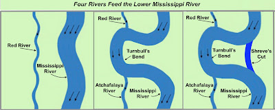
Geomorphotogy of the Old Mississippi River: Left: Over 1000 years ago; Middle: West Meander belt; Right: Shreve’s Cut

As an example, over a thousand years ago the Mississippi and Red were separate rivers and ran parallel, then in the 15th century, the Westward meander belt of the Mississippi interceded with the Red and the Upper Red becoming a tributary to the Mississippi and the Lower Red becoming a distributary named the Atchafalaya River. Finally, in the 18th century, Captain Henry M. Shreve cut off Turnbull’s bend by digging s canal
Three dams were built by the US Army Corps of Engineers in the floodgate system to keep the Mississippi River from changing course—view is to the east-southeast, looking downriver on the Mississippi, the Atchafalaya River is to the right; Bottom: two of the three dams shown in the middle of the image regulates water flow of 70% into the Mississippi and 30% into the Atchafalaya 

In 1963, the US. Army Corps of Engineers built a floodgate system of three dams across the Mississippi River to regulate the flow of water leaving the Mississippi into the Atchafalaya River and preventing the Mississippi from permanently changing course. Thus it cannot be said that Nobody knows how the Mississippi river looked like 2000 years ago.” The Mississippi is the best understood river in the Western Hemisphere and its course has been plotted back thousands of years and is well mapped and documented.

Tuesday, November 28, 2017

Iowa Drift Plain and Zarahemla

Quite some time ago we wrote an article about Zarahemla, Iowa, across from Nauvoo, and how the name Zarahemla came to be used there, as opposed to those who claim the area was the original site of Zarahelam of the Land of Promise in the Book of Mormon. 
    Since then the Heartland Theory has gained some following among members, who seem more interested in the opinions of others than the actual scriptural record and the reality of the area. In addition, we have had some wild comments from individuals who seem convinced of that location for Zarahemla. So we will address this once again.
First of all, Zarahemla, Iowa, was located adjacent to Montrose, Iowa, both in Lee County, and both across the Mississippi from Nauvoo, 10 miles north of Keokuk, the present county seat of Lee County, Iowa, and a city named after the Sauk Indian chief Keokuk. It is located in the extreme southeast corner of Iowa where the Des Moines River meets with the Mississippi. Across the river and 15-miles east along highway 136 is Carthage, Illinois.
    Second, while there are many who want to claim that Zarahemla, Iowa, is the Zarahemla of the Nephite Nation in the Land of Promise, there are four features that mark the area of Zarahemla in the scriptural record that are completely missing in Iowa:
1. Mulek and his party, after leaving Jerusalem, “at the time that Zedekiah, king of Judah, was carried away captive into Babylon, journeyed in the wilderness, and were brought by the hand of the Lord across the great waters, into the land where Mosiah discovered them; and they had dwelt there from that time forth” (Omni 1:15-16); this means that the Mulekites landed in the Land Southward, in the area that is known as the Land of Zarahemla in the scriptural record, and that the city of Zarahemla would have been very close, if not along the coast itself, since they dwelt where they landed.
2. In the Land of Zarahemla, there were valleys which rose to mountains “whose height is great” (Helaman 14:23). Since Samuel the Lamanite made such an issue out of these mountains that would shoot up during the crucifixion (Helaman 14:14) when he said, “there shall be many places which are now called valleys which shall become mountains, whose height is great” (Helaman 14:23), that would have occurred all over the Land of Promise, even in the Land of Nephi from which Samuel had come, since when he fled from the Nephites after delivering that message from the Lord, “he did cast himself down from the wall, and did flee out of their lands, yea, even unto his own country, and began to preach and to prophesy among his own people” (Helaman 16:7, emphasis added), and what he preached is what the angel told him (Helaman 13:7), which would have included the mountains “whose height is great” (Helaman 14:23).
3. The River Sidon runs along to the east of the City of Zarahemla, along the borders of the Land of Zarahemla (Alma 2:15).” This means that the River Sidon would not have been very close to the city of Zarahemla since it “ran by the land of Zarahemla” (Alma 2:15) and the eastern borders of the Land of Zarahemla would have been somewhere to the east over near the seashore where the numerous coastal cities of the Nephites were built, from Moroni in the south to Mulek in the north, of the Land Southward.
4. The head of the River Sidon was up in the mountains near the Land of Nephi, within the narrow strip of wilderness that ran from the East Sea to the West Sea and ran “north” past the Land of Zarahemla. This means that the River Sidon ran from the south (from the narrow strip of wilderness that was to the south of the Land of Zarahemla and north of the Land of Nephi) northward, past the Land of Zarahemla along the east borders and eventually emptied into a sea; presumably either the Sea East or the Sea West.
The rolling, flat country of eastern and southern Iowa, where the Iowa Zarahemla is located. Not only are there no mountains at all, there is no land forms that could be considered of great height under any stretch of the imagination

The problem for Zarahemla, Iowa, being the Nephite capital in the Land of Promise is that all four of these above descriptions do not fit the Iowa location. In addition:
1. In this case, “by the seashore,” does not fit the Iowa site since Zarahemla, Iowa, is on the west shore of the Mississippi River, which would not be the Sea West. The fact of the matter is that Zarahemla in Iowa is thousands of miles from a west sea.
2. There simply are no mountains anywhere around Iowa, or across the river in Illinois, or along the Mississippi River in northeastern Missouri.
As far inland from the Mississippi River as the eye can see, even from an elevated aerial view, the land is flat, without a hill in sight, let alone a mountain

It would be important for some type of Zarahemla artifacts being found in the area of Montrose, Iowa, however, in all of the contacts with Quashquame and his Sauk Indians, no mention is made of any time of ancient settlement there, no mention of the ruins of walls, buildings, etc., even though Quashquame was an intelligent man who, at one time, signed the treaty of 1804 as the leader of the delegation to St Louis that ceded lands in western Illinois and northeast Missouri to the U.S.
    In addition, though Brigham Young, Wilford Woodruff and Erastus Snow lived in this Montrose area only fifty some years after it was first settled by the Sauk, no mention in any of their writings shows any indication they found any ruins of walls and buildings representing a city the size and scope of ancient Book of Mormon Zarahemla, which was the capital of the Nephite Nation.
    In 1837, when Fort Des Moines was built outside Montrose, there was no use of, or discovery of, rock or stone ruins to help build the fort. In fact, prior to 1780, the area of Montrose and Zarahemla was an open field showing no previous occupancy.
All of this area in Southern Iowa is part of the Southern Iowa Drift Plain, which is the largest of the landform regions and is composed of glacial drift (gravel, sand, or clay that is picked up and deposited by the glacier as it moves), and basically flat. To the south, is the Eastern Glaciated Plains of Northeastern Missouri. Across the river, where Nauvoo sits and the entire region, is the Central Mississippi Valley, and part of the overall Illinois Central Lowlands

The area itself, part of where the Mississippi Alluvial Plain and the Southern Iowa Drift Plain meet, which is essentially the northward continuation of the fluvial sediments of the Mississippi River Delta along the river area, and the low-rolling hills covering most of southern Iowa. Two thousand years ago, this area of today’s Montrose and Zarahemla were in the wetlands stretching as far north as present day Fort Madison. This area also has the heaviest rainfall in the state, averaging 30-inches annually, and is considered a Pleistocene glacial landscape, i.e., basically flat, with slightly rolling, low-level hills.
Typical landscape and topography of the Southern Iowa Drift Plain showing a flat, slightly rolling plain that stretches over the southern half of the state of Iowa

Archeology in the State of Iowa has not uncovered any major settlement areas, such as cities of great size, nor anything more than the type of Indian cultures found there when the Europeans first came into the area. As late as 3,000 years ago (1000 B.C.), during the Late
Archaeic period, American Indians in Iowa began utilizing domesticated plants, and much later an increased dependence on agriculture. Not until around 900 A.D. did the culture in Iowa develop dependence on maize (corn) and begin to develop “nucleated” settlements; however, not until after the Europeans settled in the area did the earlier cultures develop into any semblance of sophisticated social complexes.
    This can hardly be considered the background of the 1000-year history of Zarahemla in the Book of Mormon that served as the Nephite government capital as well as its spiritual base and temple. To make claims that this is where the city of Zarahemla of the scriptural record was located is simply not to understand either the record itself, the area, or its history.
    Despite all the claims that this Zarahemla in Iowa was the Nephite city of Zarahemla is ill based and certainly does not qualify based on the scriptural record, and the topography surrounding Zarahemla that Mormon described. This Zarahemla in Iowa was simply named after the city of Zarahemla in the Book of Mormon, like Bountiful, Utah, was named after the city of Bountiful in the Book of Mormon.

Monday, November 27, 2017

Some Interesting Counter-Questions and Answers—Part III

Continuing with our listing of some interesting questions that are asked us from time to time and our counter-questions and their answer, and specifically continuing on with when the Land Northward was first occupied.) 
   As shown in the last post, not until the last century B.C. did the Nephites learn of the Land Northward and the history of the Jaredites and their annihilation. In fact, the term Land Northward is not mentioned until Mormon does so in his insertion of the location and description of the lands in Alma 22:31; and then it is not mentioned again until 73 B.C. in Alma 46:22, when the destroyed Jaredites are mentioned during the making of a covenant with God, that if they failed in fighting and gaining back their government that He would cast the Nephites at the feet of their enemies even as they had cast their garments at the feet to be trodden under foot (Alma 46:22). It is mentioned again the following year when describing that the Nephites controlled all the land northward of the land Bountiful after casting the Lamanites out of the east wilderness and on the west in the land of Zarahemla (Alma 50:11).
    In 67 B.C. is the first time the Land Northward is mentioned as a destination, when Morianton put it in the hearts of his followers that they should flee to the Land Northward to avoid Moroni’s armies (Alma 50:31). Shortly afterward, the Lamanite king Amalickiah marched toward Bountiful to take possession of it and also the Land Northward (Alma 51:30); however, the Nephites stopped that movement (Alma 52:2), and for the first time we find that the Nephites fortified the land Bountiful in 66 B.C., and secured the narrow pass which led in the Land Northward, to keep the Lamanties from gaining that are and gain power to harass the Nephites on every side (Alma 52:9).
    Then we find that Hagoth built a shipyard “by the narrow neck which led into the Land Northward” (Alma 63:5), and during 54 B.C. “many people went forth into the Land Northward.”
About 9 years later, “an exceedingly great many…went forth unto the Land Northward to inherit the land” (Helaman 3:3), and “did travel to an exceedingly great distance, insomuch that they came ot large bodies of water and many rivers” (Helaman 3:4), and “did spread forth into all parts of the land” (Helaman 3:5), and “they did multiply and spread, and did go forth from the land southward to the land northward, and did spread insomuch that they began to cover the face of the whole earth, from the sea south to the sea north, from the sea west to the sea east” (Helaman 3:8).
    Thus we can suggest that about 40 years before the Savior’s birth, the Nephites and also some Lamanites occupied the Land Northward in great numbers from sea to sea.
    As for any hidden message, it is only that the Land Northward, though numerous theorists write differently, was not occupied in any large scale numbers prior to about 55 B.C. However, it might be safe to assume that the Nephite government or leaders at one time or another researched the area completely to make certain there was no possibility that they could be attacked by an unknown people from that far northern boundary. Consequently, they could safely say, as Mormon recorded, that the Nephites controlled all the land northward of the narrow neck of land.
    This also suggests that there was a northern terminus to that Land Northward, i.e., that it did not continue northward, which verifiers Jacob’s statement that they were on an island in the midst of the sea (2 Nephi 10:20).
    In addition, we fail to find anywhere in all of this that the Land Northward was covered with “farm lands.” During Jaredite times they would have been, but after all those wars and all Jaredites wiped out, it is doubtful any farmland survived to the point it was producing useful produce, and especially after several hundred years to when the Nephites arrived in that northern land, it is doubtful that any farmland existed at all.
    Obviously, the farm lands would have begun to deteriorate from lack of care and irrigation between the time the Jaredites were fighting their last civil war of annihilation and the time the Nephites went north to inherit the land, a period of around 500 years.
    Comment Received #8: “Why do you think the rising generation did not follow along with their parents in the gospel? They were too young to understand Benjamin, but surely their parents would have taught them.”
    Our Counter-Question: “Do you think their parents taught them?
    Response: We have an interesting parallel in the story of the stripling Lamanite warriors fighting under Helaman. They fought with such great courage and did not fear death, believing in God. They claimed it was because “they had been taught by their mothers, that if they did not doubt, God would deliver them” (Alma 56:47). Even though this was a generation not involved in the original promise of their parents not to take up arms because of all the bloodshed they had caused, this generation held true to the faith of their fathers, for they had seen or heard of their fathers’ willingness to die for their faith rather than break their pledge and take up arms once again and defend themselves.
    On the other hand, the generation of Nephites under Benjamin turned out quite differently, for “… many of the rising generation … could not understand the words of king Benjamin, being little children at the time he spake unto his people; and they did not believe the tradition of their fathers.”
    The question might be, why didn’t they understand the words of king Benjamin as expressed in the tradition of their fathers? Obviously, they had been taught for “they did not believe what had been said concerning the resurrection of the dead, neither did they believe concerning the coming of Christ.”
    What was so different in these two generations? Both had parents who had a change of heart and became dedicated to living the gospel, making pledges of changed living. Both evidently taught their children. But only the extreme example of the Lamanite fathers was different. Evidently, when one is willing to die for their beliefs, a much stronger message is conveyed. And, too, we do not know that the Nephites taught this young generation that they would have nothing to fear if they doubted not—but whatever it was, the Lamanite youth believed their mothers’ teachings and their fathers’ example, while the Nephite youth could not comprehend what they had been taught.
    “And now because of their unbelief they could not understand the word of God; and their hearts were hardened. And they would not be baptized; neither would they join the church. And they were a separate people as to their faith, and remained so ever after, even in their carnal and sinful state; for they would not call upon the Lord their God” (Mosiah 26:1-4).
    How different their condition and the results of their reaction to their parents’ teachings. But we have this suggestion from Lehi as he gave this parting blessing to his living descendants before his death, “But behold, my sons and my daughters, I cannot go down to my grave save I should leave a blessing upon you; for behold, I know that if ye are brought up in the way that ye should go ye will not depart from it” (2 Nephi 4:4-5). Somehow, somewhere along the way, the Nephite youth were evidently not brought up in the way they should go, while the Lamanite youth were. Very possibly the Nephite fathers, in setting an example, were not as valiant in their doing so, or it was not as impressive to the mind of their sons, as was the example set by the Lamanite fathers.

Sunday, November 26, 2017

Some Interesting Counter-Questions and Answers—Part II

Continuing with our listing of some interesting questions that are asked us from time to time and our counter-questions and responses: 
    Comment Received #4: “What makes you think that the term “land which was northward” did not just apply to the lands north of Zarahemla, including the land which you have written about that is not named?”
    Our Counter-Question: “Why do you think that Mormon did not bother to mention those in between lands, i.e., the land not mentioned and the Land of Bountiful, Desolation, etc.? Had he not done this before?”
Mormon tells us of a land between the Land of Bountiful and the Land of Zarahemla (3 Nephi 3:3), but does not name it

Response: When Mormon was carried by his father from the Land Northward to the Land of Zarahemla, the Land of Bountiful and the land in between are also not mentioned (Mormon 1:6). It sounds a lot like that was simply the way Mormon wrote, i.e., from start to end destination. If you read Mormon’s descriptions of lands, when he is concentrating on beginning and end destinations, he rarely if ever describes the lands or areas in between unless there is a reason—and certainly, there would have been reasons important to describe where those 5400 men and their wives and children came from, where they traveled to, and why they were immigrating—all of which Mormon skips over. He also doesn’t mention anything more about location of the wars that broke out by the Waters of Sidon in the borders of Zarahemla (Mormon 1:10) and then spread all over the Land Southward until finally Mormon is forced to accede all of the Land Southward in a treaty (Mormon 2:27-29), yet he skips over all those areas and lands with hardly a reference.
    Comment Received #5: “Why didn’t Mormon say “a land,” instead of “the land.” As you know, “the” is more definitive than “a.”
    Our Counter-Question: “What is the actual meaning of “the land” as Mormon used it?”
    Response: In English, “the” is used before nouns, which is a definite article, which means they are specific or understood…“the land,” is a specific land, not just any land in general; but it is also used rhetorically before a noun in the singular number, meaning not several lands, or even two lands, but one land. On the other hand “a” is an indefinite article that modifies a noun but not specifically.
That is, “a cat” can mean “any cat,” whereas “the cat” means a specific cat. Thus, “the land which was northward” means a specific land and not just any land” whereas “a land which was northward” would mean “any land to the north.”
    What this tells us is that Mormon knew all the land in the Land of Promise and knew it very well and responded to it as “the” land in almost every case. However, it also tell us that Mormon knew of a land which was away to the north, disconnected to the Land of Promise, where immigrants went and were never heard from again, but that the land was known to exist, probably from explorers among the Nephites who had sailed there, saw what it was like, and returned to talk about it—a fact Mormon failed to abridge into the record, probably because he was constrained by the spirit since the Lord does not like to introduce outside matters of no significance to the scriptural purpose (as in not telling Abraham of other worlds, other than that they exist).
    Of course, this last paragraph is supposition since there is no scripture or verse regarding it.
    In addition, when Mormon says a ship did not return, “And we suppose that they were drowned in the depths of the sea” (Alma 63:8), there is no reason to believe that the ship sank. All Mormon knew was that it did not return, and he knew no more about it than the ship that went toward a destination he did not know (Alma 63:8). All that this tells us is that neither ship returned to Hagoth’s shipyards or were heard from again, which ought to suggest that they had no contact with the distant colony in a “land which was northward.”
    Comment Received #6: “If there is another land northward, why does the Book of Mormon only speak of one area to the north, and that is the land northward (Jaredite lands)?”
    Our Counter-Question: “Why do we not know about other worlds of which the Lord schooled Abraham? Why are we limited in our knowledge to just this world?”
    Response: If we knew about other lands, other areas where Hagoth’s voyagers went, such as the ship that they didn’t know where it went (Alma 63:8), which in modern times we are pretty certain that ship went to Polynesia and settled those islands. To know of other worlds would be distracting to our mission to work out our salvation and exaltation on this world. There may be other reasons, but evidently, as in the case of the Nephite lands, the Lord is more interested in our knowing about the Nephites and what befell them than those that left there and went elsewhere, any more than we’ve been told who settled other areas of the Western Hemisphere or to wherever the Lord has led other branches of the House of Israel, such as the ten tribes.
    The question we should be asking ourselves is if Lehi landed in Andean South America, then who settled Mesoamerica? And if Lehi landed in Mesoamerica, who settled Andean South America? Since one area is north of the other, and Hagoth’s ships of immigrants “took their course northward” (Alma 63:6) from “the narrow neck of land” (Alma 63:5), then it should suggest to us that Lehi landed to the south and Hagoth’s immigrants settled to the north.
    As should be understood, the Land Northward (Jaredite lands) is mentioned by Mormon in 30 instances. The “Land which was northward” that is not a relative or substitute for a later described land, is mentioned only once with no connection to the Jaredite Lands or the term Land Northward. Thus, there is no scriptural reference to tie that land “which was northward” to the Jaredite lands or the Land Northward.
    Comment Received #7: “What was the purpose of the Nephites that went north and found the ruins in the land northward other than to introduce the Jaredite lands and provide the record of those people? The way you refer to them all the time, you must think there is a hidden message in that situation that is lost on me.”
    Our Counter-Question: “When did the Nephites begin moving into the Land Northward that we know of as the Jaredite lands?”
    Response: First of all, it is important to keep the dates and time frames of events clear in our mind when reading the Nephite record in order to receive the greatest insight into those events. From the scriptural record we find that the first time we know of the Nephites possibly learning about the Land Northward was when Coriantumr wandered into the Mulekite camp in Zarahemla. What he was able to convey about his people and where they were and their size and scope of their civilization is not recorded and from all we can gather in Omni, the Mulekites knew nothing of this man and likely as not, nothing of the civilization northward that had been wiped out. When Mosiah arrived, he was shown a stone on which Coriantumr recorded a brief history of his people that Mosiah interpreted (Omni 1:20-22).
    It also appears that there was little interest in the history of Coriantumr, or perhaps there wasn’t enough on the stone to incite more interest. In any event, when Limhi’s 43-man expedition went northward looking for Zarahemla and became losst, winding up in the Land Northward where they encountered the bones, war equipment, and numerous buildings of every kind, they thought it was Zarahemla and that the Nephites there had been wiped out (Mosiah 7:14).
    King Limhi desired Ammon to translate Ether’s record for he did not know who those people were (Mosiah 8:12) and considered their origin a “great mystery” (Mosiah 8:19). Thus, as late as 121 B.C., the Nephites did not know anything about the Land Northward, or the Jaredites who had occupied it. Around 30 years later, in 92 B.C. Mosiah finished translating Ether’s records which “gave an account of the people who were destroyed, from the time that they were destroyed back to the building of the great tower, at the time the Lord confounded the language of the people and they were scattered abroad upon the face of all the earth, yea, and even from that time back until the creation of Adam. Now this account did cause the people of Mosiah to mourn exceedingly, yea, they were filled with sorrow; nevertheless it gave them much knowledge, in the which they did rejoice” (Mosiah 28:17-18).
(See the next post, ”Some Interesting Counter-Questions and Answers—Part III,” in which we are listing some questions that are asked us from time to time and our counter questions and their answers, and for more of those answers—and continuing on with this idea as to when the Land Northward was first occupied)

Saturday, November 25, 2017

Some Interesting Counter-Questions and Answers—Part I

We are listing some interesting questions that are asked us from time to time and our counter questions and their answers:
    Question Received #1: “Why do you think the large company of men, even to the amount of five thousand and four hundred men, with their wives and their children, departed out of the land of Zarahemla into the land which was northward, mentioned in Alma 63:4 had to do with going by ship?”
    Our Counter-Question: Why do you think Alma and Mormon wrote down the number of Nephite men, plus women and children, that “departed out of the land of Zarahemla into the land which was northward”?
    Response: Nowhere else in the entire scriptural record does Mormon state numbers of people movements, migrations, etc. (other than war and killed), though he talks about “many people who went forth into the land northward” (Alma 63:9), and also when abridging Helaman’s writing, said only “And it came to pass in the forty and sixth year…in the which there were an exceedingly great many who departed out of the land of Zarahemla, and went forth unto the land northward to inherit the land” (Helaman 3:8).
    Stated differently, why were the 5400 men plus wives and children numbered, but no other emigrants ever numbered, even though there was an exceedingly large number, etc.?
Ship’s Manifest list required on all ships from the earliest period of shipping
 
Perhaps the answer lies in the fact that ship manifests have always numbered passengers for three critical but simple reasons: 1) Cost (passage), 2) space available (size of ship) and 3) weight (ship carrying cability). Nobody cares how many people travel by land, since there were no tariffs, passenger fees, land costs, charges, space requirements, (etc.)
    Our Follow-up Question: “Why do you think those in Helaman 3:8 went into the land northward to inherit the land, while those in Alma 63:4 are not mentioned as going into the land which was northward to inherit the land”?
    Response: The Land of Promise was already promised to the Nephites, and when they moved about within it, they were merely inheriting the land already promised and given to them by the Lord. However, a land disconnected to the Land of Promise (A land which was northward) was not promised to Lehi (or the Jaredites) and they could not inherit something they did not own or was not already given to them.
    Our Second Follow-up Question: Why do you think Mormon used the term “Land which was northward”? It is only used three other times in the entire scriptures, but Land Northward is mentioned 30 times?
    Response: In the English language, “the word “which” is a pronoun relative or substitute.” It is a relative or pronoun relative because it relates to another word or thing, usually to some word that precedes it in the sentence. According to Noah Webster, this does not exist in any other language. Therefore, the use of “which” used here renders the sentence, “the land, which land was northward.”
    In the case of the two other uses:
1. “the Nephites possessing all the land northward, yea, even all the land which was northward of the land Bountiful, according to their pleasure” (Alma 50:11). In this case, the “which” is a relative or substitute for the “land Bountiful,” thus the “which was northward” relates to a known land.
2. In the case of “Morianton put it into their hearts that they should flee to the land which was northward, which was covered with large bodies of water, and take possession of the land which was northward” (Alma 50:29). In the first usage of this sentence, the “which” is a substitute for the land “covered with large bodies of water,” and in the second usage, it is a substitute for the “ellipted” noun “land” as described as “large bodies of water.”
Hagoth’s ships went to a “land which was northward”

However, in Alma 63:4, the word “which” has no substitute (no other land or noun is described) and therefore is a relative of the land mentioned, i.e., a land which was northward.
    In one response to this line of thinking, a reader once stated: “If Mormon had said, “into a land which was northward,” then any land that was northward of the land of Zarahemla would do.” But that is not true, nouns are often connected to a modifier somewhere in the sentence or preceding or subsequent sentence. Thus, if that was Mormon’s intent, it would have to be “departed into the north countries,” “went into the northern lands,” “left Zarahemla to the lands to the north,” “they went northward,”
    Question Received #2: “Why would someone think those in Alma 63:4 are not just going to the Land Northward by ship?”
    Our Counter-Question: “Why would Mormon write about two different immigrations into the same areas? And if not the Nephites, then who created both the sites of similar construction and cultural achievement as found in Andean South America and in Mesoamerica?”
    Response: Unless one has been dedicating his life to believing and promoting the erroneous area of Mesoamerica as the Land of Promise given to Lehi, one cannot explain why there are two very similar cultural locations in the Western Hemisphere that date nearly to the same time frame and are very similarly built and signify a similarly advanced race that co-existed for about half of the same 1000-year time frame.
    In fact, since non-LDS archaeologists and anthropologists working in both the Mesoamerican and South American areas all agree that the Andean area of South America was developed first and the Mesoamerica area developed second, it should be easy for anyone to understand that some of those in Andean South America went north into Central and Mesoamerica.
    Question Received #3: “Why would someone think that Mesoamerica had to be reached by ship? Why not simply travel up across Panama into Central America?
    Our Counter-Question: “How could any immigrants going northward beyond the Land of Promise reach there except by ship to at least get across the Central American Seaway?”
The Darién Gap blocks all overland traffic from South America northward into Central America

Response: First of all, traveling through the Darién Gap in antiquity, and even today, is almost impossible—not only has it never been done (except under very special and difficult circumstances) even in modern times with motorized vehicles, helicopters, GPS, etc., it certainly could not have been accomplished in the time of the Nephites. Based on the impasssable terrain in the Gap alone, it would seem that such travel from Andean South America to Central and Mesoamerica would have to have been by ship.
    In addition, when we consider that the entire area of the Panama Isthmus (known historically as the Isthmus of Darién) was underwater at the time as geologists tell us that the Central American Seaway once separated Central America from South America allowing the waters of the Pacific and Atlantic Oceans to mix freely.
Before the Isthmus of Panama rose from the sea by tectonic and volcanic action, the Central American Seaway linked the Atlantic to the Pacific as one great ocean. Smithsonian researchers continue to debate when and how that happened (Smithsonian Tropical Research Institute)

Beneath the surface, two plates of the Earth’s crust were slowly colliding, forcing the Cocos Plate to slide under the Caribbean Plate. The pressure and heat caused by this collision led to the formation of underwater volcanoes, some of which grew large enough to form islands, while movement of the two tectonic plates were also pushing up the sea floor, eventually forcing some areas above sea level and forming the Isthmus of Panama as we now know it.
    Obviously, going by ship would have been essential before the landform changes at the time of the Crucifixion. As the Disciple Nephi wrote: “But behold, there was a more great and terrible destruction in the land northward; for behold, the whole face of the land was changed, because of the tempest and the whirlwinds and the thunderings and the lightnings, and the exceedingly great quaking of the whole earth; And the highways were broken up, and the level roads were spoiled, and many smooth places became rough…And thus the face of the whole earth became deformed, because of the tempests, and the thunderings, and the lightnings, and the quaking of the earth. And behold, the rocks were rent in twain; they were broken up upon the face of the whole earth, insomuch that they were found in broken fragments, and in seams and in cracks, upon all the face of the land” (3 Nephi 8:12-13, 17-18).
    It should be of note to all that in the scriptural record we have a written event of that very thing occurring. So again, why would one not think those five thousand and four hundred men with their wives and children sailed to a land which was northward, meaning disconnected from the Land of Promise?
(See the next post, ”Some Interesting Counter-Questions and Answers—Part II,” in which we are listing some interesting questions that are asked us from time to time and our counter questions and their answers, and for more of those answers)

Friday, November 24, 2017

The City of Nephi – The Fortress of Sacsayhuamán – Part III

Continuing from the last post on the City of Nephi based on the scriptural account and the evidences today found at Sacsahuaman in Cuzco, Peru. 
    Mormon wrote: “and also building walls of stone to encircle them about, round about their cities and the borders of their lands; yea, all round about the land” (Alma 48:8). We discussed these walls at Sacsahuaman in the last post.
While the fortress overlooks the city of Nephi, it is also above the City of Shilom, which was next to the City of Nephi (Mosiah 9:6), which was called the City of Lehi-Nephi by Zeniff, (both were in a valley, overlooked by hills). As it states in the scriptural record, Ammon and his party, in search of those who had left with Zenniff, “came to a hill, which is north of the land of Shilom” (Mosiah 7:5), and leaving some there, he and three others “went down into the Land of Nephi” (Mosiah 7:6). When king Limhi sent his guards to get the others, “caused that they should go to the hill which was north of Shilom, and bring their brethren into the city” (Mosiah 7:16).
    We also know that the Land of Nephi in general is at a much higher elevation than the Land of Zarahemla, for it is said, “Zeniff went up out of the land even until the time that he himself [Ammon] came up out of the land” (Mosiah 8:2), i.e., both went up out of the Land of Zarahemla to the higher elevation of the Land of Nephi.
    To the south of the Land of Shilom, the Nephites had fields and lands planted with crops, as well as the place they kept their herds (Mosiah 9:14), and there was located the City of Nephi (Mosiah 9:15). And beyond the City and area of Nephi, evidently near the Land of Shilom, was located the Land of Shemlon (Mosiah 10:7-8). Evidently, somewhere between these two cities, was a valley or plain large enough for a battle to take place of such numbers, that the Nephites did not bother to count the dead Lamanites (Mosiah 10:20) and from that point, after their victory, the Nephites “returned again to our own land” (Mosiah 10:21), suggesting that this major battle did not take place in the Land of Shilom.
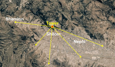
    Now in the area of Shilom, there is another city further north and west, about two miles from Shilom, which fits the location of Shemlon, and in between is a narrow valley green belt and tableland where such a battle could have taken place.
In king Noah’s time, following these events, he built the tower next to the temple in the City of Nephi, “a very high tower, even so high that he could stand upon the top thereof and overlook the land of Shilom, and also the land of Shemlon, which was possessed by the Lamanites; and he could even look over all the land round about” (Mosiah 11:12). From Sacsahuaman, the view down into the Valley and the city of Cuzco provides one atop Noah’s tower of a view of all three entrances into the valley, including the land of Shilom and Shemlon. It was later, from this very tower, that Noah “cast his eyes round about toward the land of Shemlon, and behold, the army of the Lamanites were within the borders of the land” (Mosiah 19:6).
    Noah built up not only the City of Nephi, but also the land and city of Shilom. “And it came to pass that he caused many buildings to be built in the land Shilom; and he caused a great tower to be built on the hill north of the land Shilom, which had been a resort for the children of Nephi at the time they fled out of the land; and thus he did do with the riches which he obtained by the taxation of his people” (Mosiah 11:13). 
    As a result, there should be in the Land of Promise a major city, with a temple and a tower next to it, from which height one could see over a large land to the north (Shilom) where major buildings were located (Mosiah 9:8). There was also nearby to the City of Nephi, probably within a one or two-day journey for it was located “in the borders of the land” (Mosiah 18:13), an area called “The waters of Mormon” where numerous baptisms took place (Mosiah 18:16), in an area called Mormon—or maybe the Land of Mormon (Mosiah 18:30) wherein was also the forest of Mormon (Mosiah 18:30).
    However, finding such a landmark more than 2000 years later, is tenuous at best, especially considering the destruction recorded in 3 Nephi, with mountains tumbling into valleys and flat land rising into mountains, “whose height is great,” it would be difficult to match, and any such suggestion would be questionable at best. All we can surmise from it would be that it was small enough to be searchable by the king’s army, yet large enough for Alma to hide in and not be found, and provide cover for 450 people (Mosiah 18:35).
The hill upon which Ammon rested above the city of Shilom before going into the land of Nephi

At the base of the hill upon which Sacsahuaman sits and the tower that Noah built, which was found when the Spanish arrived, is an area considered by archaeologists to be a very old community, that matches the area described in Mosiah 11:13 that is called the land Shilom. According to Ammon, they stopped on a hill overlooking the Land of Shilom, and he and three companions (Amaleki, Helem, and Hem) left the rest of their party on the hill and went down into the land of Nephi (Mosiah 7:6), thus, the hill where the fortress and tower was located overlooked both the city of Shilom and the city of Nephi.
    There, king Limhi outside the walls of the city at that moment, saw Ammon and his friends, and thinking they were the evil priests of Noah, had his guards tie up the intruders and cast them in prison.
It is also interesting that Zeniff’s descriptipn as Mormon abridged it of their tilling and planting their fields after twelve years of peace, it is written: “For, in the thirteenth year of my reign in the land of Nephi, away on the south of the land of Shilom, when my people were watering and feeding their flocks, and tilling their lands, a numerous host of Lamanites came upon them and began to slay them, and to take off their flocks, and the corn of their fields” (Mosiah 9:14, emphasis added). Note that it says “away on the south of the land of Shilom.”
    All of this fits into the Valley of Cuzco, with Sacsahuaman and the tower to the north, Shilom at the foot of the hill, and the hill upon which Ammon arrived overlooking both the city of Shilom and the city of Nephi. In addition, with Shemlon so identified, the Lamanites had unobserved access to reach the fields in which the people of Zeniff tilled the land and watched their flocks to the south in the land of Shilom.