Saturday, June 30, 2018

The North Countries – Part VI

Continued from the previous post regarding the north countries of the Nephites, and the entire western coastal desert strip along with the settlements that anciently existed there.
    As stated previously, this desert in the southwest is littered with round river rock-lined funnels called puquios, that provide a circular walkway down into the aquifer and subterranean river that flows beneath the desert from the mountain area to the sea.
    These subterranean aqueducts were built near the present city of Nazca, with a series of acequias or canals that brought to the surface water from the underground water source and channeled it to the areas where it was needed. Any excess was stored in surface kochas or reservoirs, which served as wells and as distribution points for directing the water into the canals. To help keep the water flowing, chimneys were excavated above the canals in the shape of corkscrewing funnels. These funnels admitted wind into the canals, and the difference in atmospheric pressure along the canal length forced the water through the system and eventually to the desired destination (recent satellite imagery also revealed additional previously unknown puquios in the Nasca drainage basin).
Paracas or Nazca aqueducts that dotted the surface were sophisticated hydraulic systems that allowed the ancient cultures to retrieve water from underground aquifers, with the water drawn to the surface by the funnel-shaped holes turned the area into a flourishing landscape able to support agriculture

These surface reservoirs would have provided water for Coriantumr’s army as they moved through this highly arid desert of rocky land and a scarcity of fertile soil, broken by cacti and twisted Schinus molle trees (Peruvian pink pepper), whose large evergreen canopy provided some shade in the hot sun along the yunga (warm, sterile valleys) before reaching the coast where the salty sea breeze and chilly winds would have revived his forces. There, he turned northward in his design for an eventual surprise attack on the city of Zarahemla.
    According to research scientist Rosa Lasaponara, of the Institute of Methodologies for Environmental Analysis in Italy, who has worked on this puquios system, claims that it was much more developed anciently than it appears today.
    The early Paracas, who first settled here were, in turn, followed by the Nazca, who settled in the arid, sub-tropical deserts of the Ica, Nazca and surrounding valleys. They were a people who produced an array of crafts and technologies such as ceramics, textiles, and geoglyphs—specifically the Nazca Lines, with their principle sites being Cahuachi at 1200 feet elevation, and directly across the Pampa de San José on the flanks of the Ingenio River tributary, the sister city of Ventilla, one of the largest urban sites at 200 hectares and hundreds of habitation terraces containing the remains of densely connected houses, some large enclosures an a few artificial mounds with open bounded khanchas in between.
    In addition, archaeologist and ethnologist (ethnohistory is a branch of anthropology that analyzes cultures, especially in regard to their historical development and their differences), William Duncan Strong, President of the American Ethnological Society, and Loubat Professor at Columbia, was one of the only archaeologists that took a broad approach to the site, contextualizing it within Nazca society and south coast prehistory. He set out to find stratigraphic evidence that would resolve the gap between Paracas and Nazca styles in the region. He also did settlement pattern studies in order to find out the kinds of activities that went on at Cahuachi—a 370-acre complex of impressive construction about 18 miles from the current town of Nazca. Strong’s findings led him to believe that the Paracas built the early cities attributed to the Nazca, and we may conclude that there was considerable evidence to link these two cultures into one overall people.
    In any event, the Nazca were concentrated in the Rio Grande de Nasca drainage, an area classified below 2000 feet as a “pre-montaine desert formation.” Here the area’s rivers originate high in the Andes and the water flows of the coastal valleys is entirely dependent on rainfall in the highlands, which incorporates nine separate tributaries covering an area over 6600 square miles and includes the rivers of Ingenio, Palpa, Aja, Tierras Blancas and Taruga, which extend high into the Andes where they collect the summer rains and water from melting glaciers to provide sustenance in the valleys below.
    According to archaeologist Donald A. Proulx, University of Massachusetts in “The Nasca Culture: An Introduction,” the vast majority of domestic sites were small villages or hamlets measuring under 4 ½ acres in size, and located well inland usually flanking the tributary rivers and not along the coast, leaving the coastal desert corridor unoccupied—something that the defector Coriantumr would have well understood, having been born and growing up in Zarahemla, as he led his army through the area toward the city.
    The largest of the Nazca settlements was the massive pyramid complex known as Cahuachi, which was located 250 miles south of Lima and several miles inland from the coast.
Top: The Cahuachi truncated pyramid complex of Cahuachi about six miles south of Nazca. There are 36 to 40 separate pyramids in this isolated area, and it is claimed they were abandoned at the close of the fourth century AD

Along this southwestern coast runs the Nazca river which flows underground for about nine miles to the east and resurfaces like a spring on the doorstep of Cahuachi. In fact, according to Anthropologist Helaine Silverman, who specializes in “Peru/Central Andes Studies,” and author of Ancient Nasca Settlement and Society, and Handbook of South American Aarchaeology I and II, in discussing the Nazca region: “The heartland of Nazca culture river system encompasses some 6,680 square miles, with its upper reaches in Ayaucho and Huancavelica, its lower portions in Ica, and is exceptional because it is formed of many affluents [tributaries] with only one outlet to the sea, the Grande River itself” (Helaine Silverman, Cahuachi in the Ancient Nazca World, Universit of Iowa Press, Iowa City, 1933).
    In addition, the Nazca culture built more than 40 subterranean aqueducts more than 1500 years ago in teh 5th Century AD or earlier (Katharina Schreiber and Josue Lancho Rojas, Irrigation and Society in the Peruvian Desert, Lexington Books, Lanham, Maryland, 1999, p6), and have never been fully mapped and none have been excavated (M. Barnes, “Dating of Nazca Aqueducts,” Nature, Vol.359, No.111, 10 September 1992). These aqueducts, or  puquois, ensured the supply of water to the city of Nazca and the surrounding fields, allowing the cultivation of crops in an arid region. Nearly all are still operating and even relied upon to bring fresh water into the arid desert (Judith Proulx  and Donald A. Rickenback, Nasca Puquios and Aqueducts, University of Massachusetts, originally published as Nasca: Geheimnisvolle Zeichen im Alten Peru, ed Judith Rickenbach, Museum Rietberg Zürich, Zürich, 1999, pp89-96).
When the defector Coriantumr with his Lamanite army reached the coastal area past the Nazca settlements, he turned north toward Zarahemla

Once through this area, Coriantumr would have then turned northward along the coast through the hyper-arid, northern-most extent of the Atacama Desert, which runs along a low altitude, narrow strip between the Pacific littoral and the foothills of the Andes. Crossing the Ingenio River, one of six major rivers and several minor tributaries that come together in the Río Grande de Nasca drainage. The Ingenio reaches its confluence with the Grande River near Chiquerillo at 735 feet elevation, after running nearly 56 miles from its headwaters in the highlands at over 13,120 feet. Together with the other rivers of the drainage, the Santa Cruz, Grande, Nasca, Palpa, and Vizcas, of the Ingenio’s valley reach the sea where there is no delta of rich alluvial deposits like most Peruvian rivers.
The foothills along the eastern edge of the desert coastal strip in the area of Nazca north to Ica. It is a desolate area with few settlements and open desert land

Coriantumr moving north along this narrow coastal strip would have hugged the foothills, keeping well out of sight of anyone in the area, though he would have been many miles from an occupied settlement. However, the closer he came to the coastal city of Zarahemla, the more chance for discovery and he did “march forth at the head of his numerous host, and came upon the inhabitants of the city, and their march was with such exceedingly great speed that there was no time for the Nephites to gather together their armies” (Helaman 1:19). Now, Coriantumr well understood the defenses of Zarahemla and the surrounding area, and knew that with “so much contention and so much difficulty in the government, that they had not kept sufficient guards in the land of Zarahemla; for they had supposed that the Lamanites durst not come into the heart of their lands to attack that great city Zarahemla” (Helaman 1:18), which is exactly why Coriantumr made his approach directly to Zarahemla and not the cities in the east first, such as in the lands of Moroni and Lehi, but came across the Land of Nephi to the west coast, and then straight up to Zarahemla.
    Thus, when he reached the city, he was able to easily fight his way into it and conquer the capital because of his surprise approach from the south and not form the east, which had always been the Lamanite route into the Land of Zarahemla in the past. From there, as we stated earlier, Coriantumr went northward, toward the “north countries,” taking the central route or road through the highlands toward Bountiful. Wanting to cut his way through the unprotected Nephite lands, destroying his enemy as he went, Coriantumr chose to travel up “he center of the land, therefore he did march forth, giving them no time to assemble themselves together save it were in small bodies; and in this manner they did fall upon them and cut them down to the earth” (Helaman 1:24).
    However, his march “through the most capital parts of the land, slaying the people with a great slaughter, both men, women, and children, taking possession of many cities and of many strongholds” (Helaman 1:27) slowed his progress, and allowed Moronihah to send “Lehi with an army round about to head them before they should come to the land of Bountiful” (Helaman 1:28), and Moronihah brought his army up behind Coriantumr’s forces (Helaman 1;30), and the Nephites caught the Lamanties between their two strong forces, killing Coriantumr, and eventually recapturing the city of Zarahemla (Helaman 1:33).

Friday, June 29, 2018

The North Countries – Part V

Continued from the previous post regarding the north countries of the Nephites, and their relationship to the north lands of Andean Peru.
    Obviously, the “north countries” were full of various settlements, cities, forts and fortresses, built over the Nephite period, whose ruins lay scattered over the countryside today. The further north we go, the less work and studies that have been done by modern archaeologists and anthropologists to discern knowledge of the early inhabitants and cultures that frequented the area anciently.
The “north countries” of northern Peru, where pre-historic settlements abounded (current name of the ruins are those of modern archaeologists origin, not the original names of the early settlers)

Some historians, knowledgeable about the Peruvian mountain highlands, the rainforest, and Amazon jungle with its torrential downpours, without checking on the facts, have considered that the western coastal region was sparsely occupied because of the desert conditions. However, such is not the case. In addition to the current major cities of Lima, Trujillo, Chiclayo and Tacna, which are all located along the coast, anciently there was a considerable amount of settlement in the coastal region. Here, during winter months the shoreline gets shrouded in sea mist, called the Garúa, which can deposit moisture on the ground, and intermittent pockets of rain, while the northern coast remains pleasant all year round.
    The desert strip itself, called la Costa, has a mild climate, cloudy and foggy in winter and pleasantly warm in summer, with the overall temperature varying little throughout the year, much like spring weather. It is a desert because it almost never rains, while the coastal Humboldt Current cools the lowest layers of the atmosphere, inhibiting the formation of vertical air currents, which are necessary for raincloud formation. However, this situation in which cold air clings to the soil or the sea surface, leads to the formation of the fog and clouds, which occur often, especially in the cold season, while sunshine prevails above 1,600 feet, as happens in the Andean area lying above the foggy layer. The temperature along this strip ranges from 64º F., to 75º F., and a degree or two cooler in the north coast and five degrees cooler in the southern coast.
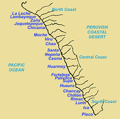
    Despite this desert condition and lack of rain, more than 20 rivers flow down from the mountains and across this narrow desert strip to the sea, supporting enormous growth especially for the coastal settlements that anciently dotted the landscape. There was also a huge growth area in the high valleys, where some of the runoff water from the mountains was diverted in ingenious irrigation systems built by the ancients.
The Peruvian Coastal Desert with the 22 main rivers that flow down from the western Andes and into the Pacific Ocean

It was the location of these rivers and more importantly the settlements along them, that Moroni’s army was involved in subduing and defending this western coastal strip that prompted him to write Teancum, who was asking for his help in the east, saying: “I would come unto you, but behold, the Lamanites are upon us in the borders of the land by the west sea; and behold, I go against them, therefore I cannot come unto you” (Alma 52:11). In fact, a little later, after Moroni had established armies “to protect the south and the west borders of the land, and had begun his march towards the land Bountiful, that he might assist Teancum with his men in retaking the cities which they had lost” (Alma 52:15).
    It was also these rivers that hindered troop movement directly along the coast, causing Coriantumr, after capturing Zarahemla, which was on the west coast where Mulek landed and settled (Omni 1:16), to go up the center of the land, along the central highland valleys where the main north south road had been earlier built.
    As Mormon tells it: “And now when Coriantumr saw that he was in possession of the city of Zarahemla, and saw that the Nephites had fled before them, and were slain, and were taken, and were cast into prison, and that he had obtained the possession of the strongest hold in all the land, his heart took courage insomuch that he was about to go forth against all the land. And now he did not tarry in the land of Zarahemla, but he did march forth with a large army, even towards the city of Bountiful; for it was his determination to go forth and cut his way through with the sword, that he might obtain the north parts of the land. And, supposing that their greatest strength was in the center of the land, therefore he did march forth, giving them no time to assemble themselves together save it were in small bodies; and in this manner they did fall upon them and cut them down to the earth. But behold, this march of Coriantumr through the center of the land gave Moronihah great advantage over them, notwithstanding the greatness of the number of the Nephites who were slain” (Helaman 1:22-25).
    Another factor involved with Coriantumr was his earlier very successful surprise attack on the city of Zarahemla (Helaman 1:19-20). Being a descendant of Zarahemla and a Nephite defector over to the Lamanites (Helaman 1:15), Coriantumr was well aware of the conditions in and around the city of Zarahemla, knew where their lookouts, city guard and approaches to the capital city would be located. In this surprise attack, he was able to “march with such exceedingly great speed that there was no time for the Nephites to together their armies” in defense (Helaman 1:19).
In Coriantumr’s march on Zarahemla, a southwest route would have taken him through mostly uninhabited areas with the only basic settlements to avoid would be Paracas and Pisco once turning northward along the coastal area—Chilca further north was merely a fishing village and unlikely to have had any military force present. Once near Zarahemla driving up the coastal area and holding to the foothills on the east of this narrow area, where he might have encountered Nephite lookouts or military squads, his “march was with such exceedingly great speed that there was no time for the Nephites to gather together their armies” (Helaman 1:19)

As we have discussed in earlier articles, this surprise attack took him southwest through the approach across the high desert and river valleys, through the area known today as the Nazca Desert, an area lightly inhabited and one Coriantumr knew was poorly defended since the Nephites would not have considered this remote, desolate, almost waterless desert a workable approach into the Land of Zarahemla, where the Nazca lines are located today, Coriantumr would have been south of the area where Moroni was defending the western coastal settlements north of Zarahemla at the time of Teancum and Helaman’s defense of the eastern seashore cities of Moroni, Lehi, and Morianton.
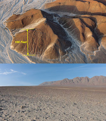
Top: Nazca lines carved into a mountain side, with a 100-foot high image of a man—some of the images on the flat land are as long as 1200-feet; Bottom: The Nazca desert, a barren and near-empty 6700-square mile coastal desolate tract of wilderness
In this south coastal area, before the Nazca culture arrived around 200 BC, are several pampas (extensive, treeless plains) covering many square miles between settlements where Coriantumnr’s army could pass unobserved.
    In this area, the Paracas culture flourished in the area of the Pisco, Ica and Nazca valleys between 800/600 BC and 100 BC. The Paracas (para-ako, a Quechua word meaning “sand falling like rain”), was one of the earliest known complex societies, who had an extensive knowledge of irrigation and water management, were also exceptional craftspeople and produced exquisitely worked stone clubs, obsidian knives, gourd bottles, rattles, pottery, shell and bone necklaces, hammered gold face and hair ornaments, as well as feather fans and basketry.
    In addition, extremely complex textiles were their highest interest, and worn to indicate status and authority. Some textiles were over 110-feet in length and would have required large numbers of people and complex organization to make, and were crafted from camelid wool of the llama and alpaca as well as cotton plant fibers produced using natural dyes of indigo, green, browns, pink and white (Anne Paul, Paracas Ritual Attire: Symbols of Authority in Ancient Peru, University of Oklahoma Press, Norman, OK, 1990). Some of these dyes were obtained from the fast-growing Andean alder tree, which grows on the mountains and in skeletal soils, and produces both a brown and a red dye from the outer bark, a yellow dye from the inner bark, and a green dye from young leaves.
(See the next post, “The North Countries – Part VI,” for more about the Peruvian north countries and its relationship to the events of Mormon’s eventual retreat toward Cumorah)

Thursday, June 28, 2018

The North Countries – Part IV

Continued from the previous post regarding the north countries of the Nephites, and their relationship to the north lands of Andean Peru.
The Lamanites did come upon us with exceedingly great power, insomuch that they did frighten my armies; therefore they would not fight, and they began to retreat towards the north countries” (Mormon 2:3)

Now, as the Nephites under Mormon’s command retreated further into the “north countries,” they would have encountered an area today called La Congoña of the Chachapoyas culture that was built of stone and placed symmetrically with clay amalgam located in an area of humid forest in the central Andes at an altitude of 9300-feet, about 50 miles northeast of Chiclayo, 80 miles north and a little west of Cajamarca, and 95 miles west and a little north of Kuélap, which was another formidable mountain fortress.
     Though the true dating is unknown, archaeologists have considered the questionable dating they use that is much later than the Nephites, though the fortress is claimed to have been built in the Middle Horizon period, which pre-Hispanic Andean scholar, archaeologist and anthropologist John Howland Rowe, places at 500 AD. The interesting description about the site was its isolated location and most importantly that it was built as a military fort for defense. 
    Not much is known about the Chachapoyas or when they dominated the north country but their culture left a significant number of large stone monuments, such as Kuélap, Purum (Purumllaqta), and Cerro Olán, the latter a hilltop stronghold with 500 buildings placed along a half moon shape. These “Warriors of the Clouds,” so named byh others because their cities were hill or mountain-top fortresses built high up in the cloud forests of the Andes toward the central and eastern reaches of the land. In fact, the Quechuan name “Chachapoya” itself means “Cloud Forest.”
    Located about 340 miles north of Lima, their territory encompassed the basin 150 miles long by 60 miles wide within the triangular region on the eastern flank of the Andes formed by the confluence of the Marañón River and the Utcubamba in Bagua Providnce up to the basin of the Abiseo River where the Gran Pajáten is located. In fact, the archaeological site of Gran Pajáten sits on a hilltop above the Montecristo River valley, and consists of a series of at least 26 circular stone structures atop numerous terraces and stairways, occupying an area of about 65,617 square feet. The principal buildings are decorated with slate mosaics which ceramic samples and radiocarbon dates show that the area was occupied as early as 200 BC., and ceramic technology existed much earlier. According to archaeologists, this site was first developed as a hill-top fortress to defend against enemy incursions from the south.
Hill-top fortresses commanding 360º views of the approaches marked the Chachapoya hill-top fortresses

Another site in this area is Gran Saposa, a series of cloud forest ruins that includes hundreds of round stone structures and covers approximately 80 square miles, and was home to about 20,000 occupants. Another was Atumpucro is a complex of over a hundred and fifty circular Chachapoya-stye buildings within an impressive stone fortification, similar to the Kuélap fortress, and perched on Atumpucro hill along the western shores of the Utcubamba River in the province of Luya. The city extends for more than two hectares, at an altitude of over 11,000 feet with the structures built on large terraces dug along the ridge of the mountain, with the old city surrounded by a wall 165 feet long and ten feet wide, with the complex described as being in a good state of preservation.
High walls with extremely narrow entrances mark the perfect arrangement for a easily defended fortress

There were many other pre-Columbian and pre-historic sites located in northern Peru, both along the coast and within the interior highlands of which their remains have been uncovered in surviving pyramids, buildings, and the ruins of their culture.
    Just about everyone who knows of Peru, has heard of Machu Picchu, and to a lesser extent, Pachacamac, Nazca, Kuélap and other large tourist attractions; however, the hundreds of other sites are far less known or visited, nor today the object of archaeological study and field work. Occasionally a new site is located, such as the massive Llanganates pyramid about fifty miles south of Quito and 20 miles northeast of Banos de Agua Santa (near Ambato), in the remote jungles of Ecuador, Ecuador, standing 260-feet tall and 260-feet wide made up of hundreds of two-ton stone blocks with the possibility of additional similar constructions over a square mile, claimed to have been built prior to 500 BC. Bruce Fenton, an Ecuador-based Briton and researcher into the region’s indigenous cultures, and Benoit Duverneuil, a French-American archaeologist, believe the site could contain a city, perhaps the size of Machu Picchu, and much older than 500 BC. “This could be one of the biggest archaeological discoveries ever,” Fenton said of the site. “It would be huge. We just don’t have structures of this type and size in this part of the world.”
Left: The huge stone pyramid in the Llanganates National Forest; Right: The Hummingbird Pyramid near La Maná, which are only two of the many discoveries made in the jungles of Ecuador that go unnoticed by archaeologists

At 8,500 feet above sea level and in cloud forest where it rans most of the time, the precise extent of the structure and the possible wider development has not yet been gauged. The actual shape of the structure cannot be determined because it is covered by mud and vegetation, but it is massive and definitely man-made, ready for extensive excavation, study and evaluation. Unfortunately, Ecuador’s archaeological ruins attract a limited number of tourists and government spending is limited. Or the recently discovered Hummingbird Pyramid and megalithic ruins that was uncovered just south of La Maná, Ecuador, along the Calopoe River, when road workers set of a dynamite blast that uncovered the pyramid.
    However, the extensive archaeological work accomplished by BYU and other North American groups in Mesoamerica, have seldom, if ever, ventured into South America, with only a few European archaeologists working in the Andean area. As a result, the work being done down there is mostly by Peruvian or Ecuadorian archaeologists and the press coverage of such work is seldom of major interest in North America.
    Consequently, the largest and oldest pre-historic sites ever uncovered in the Americas, in fact the entire Western Hemisphere, are seldom known, and their artifacts seldom reach museums in the United States—mostly kept in Peru, Ecuador and Chile, though some have made their way into European museums. This has led to, over the years, so many theorists making the claim that those who find Andean South America the location of the Land of Promise have no “evidence,” no “artifacts,” no important discoveries.
    What is also interesting is that while Peru and Bolivia have experienced some archaeological work, especially Peru, Ecuador, Colombia and Chile have had very little work done, undoubtedly making this area one of the most neglected territories archaeologically speaking. According to many archaeologists, it is in these countries where most of South America’s ancient ancestors’ treasures are hidden.
    It is also interesting to know that while North American archaeologists claim they have found arrowheads that date to approximately 10,000 B.C., these same non-building evidences (such as bones and charcoal) existing in South America date to 16,500 B.C., at Monte Verde in southern Chile (Mark Rose, “The Importance of Monte Verde,” Archaeology, Archaeological Institute of America, October 18,1999). This is seven thousand years older than the previous dates of the Clovis of North America at 9500 B.C. In fact, nothing dates in North America before 10,000 B.C. (Please note that we are using the established carbon dates used by geologists and other scientists in order to show earlier and later periods—the actual dates would be much different, but the differences in dates would not be affected; that is, 16,500 is much older than 10,000, irrespective as to what the actual scaled-down calendar dates would be in accurate measurement).
The many different cultures that anthropologists claim existed during the Jaredite and Nephite time period throughout Andean Peru; however, they have ignored the many relationships that tie these groups together

Yet, using settlement structures and not a scattering of arrowheads, but actual ruins of major developments, Huaca Prieta, north of Lima, dates to 5800 B.C., Sechin Bajo, Ancash, Peru, dates to 3600 B.C., Huaricanga (in the Fortaleza Valley, dates to 3500 BC, Caral-Supe dates to 3300 B.C., and predated the Mesoamerican Olmec (1200 BC) civilization by nearly two millennia (Charles Mann, 1491: New Revelations of the Americas Before Columbus, Vintage Books, 2006, pp199-212).
    The oldest mine ever found in the Americas is an iron oxide mine near Taital in northern Chile that marks the oldest evidence of organized mining ever found in the Western Hemisphere, dated to 10,000 B.C., and the Huentelauquen culture, who extracted 700 cubic meters and 2,000 tons of rock were extracted. Carbon dates for charcoal and shells found in the mine suggest is was used continually for some 1500 years, and then again in 2300 B.C. (Diego Salazar et al., Current Anthropology, Vol.552, No.3, June, 2011). Compare with the oldest copper mine in North America dated between 2500 B.C. and 600 B.C. (University of Chicago Press Journals, Science Daily, 20 May 2011).
(See the next post, “The North Countries – Part V,” for more about the Peruvian north countries and its relationship to the events of Mormon’s eventual retreat toward Cumorah)

Wednesday, June 27, 2018

The North Countries – Part III

Continued from the previous post regarding the north countries of the Nephites, and their relationship to the north lands of Andean Peru. An area referred to by archaeologists of today as the Norte Chico. It might be of interest to know that in this area of Norte Chico, thirty major population centers sprang up over time along this north-central coast of Peru. The Norte Chico civilization of Caral is one of the oldest and most sophisticated in the world, having flourished between the thirtieth century BC. and the eighteenth century BC. The alternative name, Caral-Supe, is derived from Caral in the Supe Valley, a large and well-studied Norte Chico site.
    It emerged just a millennium after Sumer in Mesopotamia, was contemporaneous with the pyramids of Ancient Egypt and predated the earliest culture of Mesoamerican. The most impressive achievement of the civilization was its monumental architecture, including massive ceremonial pyramids built on a base of large platform mounds, and sunken circular plazas, along with a complex irrigation system.
Artist’s rendition of the major pyramid found at Caral-Supe, one of six such pyramids. It had 160 x 150-foot o base and 60-foot of height (six stories), with a circular sunken plaa located in front of the acce3ss staircase which reached the summit where the main enclosure was located, the atrium and the altar, with the whole complex was supported on a platform

These pyramids, which are terraced and rectangular in shape, were built of stone. In Caral, a total of six pyramids have been discovered, the largest of which is the “Pirámide Mayor” (Major Pyramid), which was built around 2620 BC. It had 160 x 150 of base and 18 meters of height. Next to it were other pyramids or elevated platforms that constituted a ceremonial center. First the walls of the platform were built by filling sacks of mesh with wide gaps with ashlars, then the outer surface was covered with colored mortar. It consists of a circular plaza that is located in front of the access staircase, which reached the summit where the main enclosure was located, the atrium and the altar of the sacred fire. The whole complex was supported on a platform.
    In addition, archaeological evidence suggests the use of textile technology and, possibly, the worship of a common god, both of which recur in pre-Columbian Andean cultures. Sophisticated government is assumed to have been required to manage the ancient Norte Chico, and questions remain over its organization, particularly the impact of food resources on politics.
    Its sophistication should suggest to all that no one part of the world can claim to have led the whole world and the whole human race in developing technology, culture, society, political organization or ideas of the divine.
    Much study has been done on the diet of the coastal cities, especially that of Caral, whose lack of ceramics have interested many archaeologists. Much early fieldwork was done in the region of Aspero on the coast before the full scope and inter-connectedness of the civilization was realized.
Aspero along the central Peruvian coast, west of Caral, but on a defensible hilltop just north of the Supe River

In a 1973 paper, Michael E. Moseley confirmed a previously observed lack of ceramics at Aspero, and deduced that housing arrangements on the site were built on artificial platforms, and contended that a maritime subsistence—a seafood diet—had been the basis of the society and its remarkably early flourishing (Michael E. Moseley and Gordon R. Willey, “Aspero, Peru: A Reexamination of the Site and Its Implications," American Antiquity Vol.38, No.4, 1973, pp452–468).
    His theory was later elaborated as a "maritime foundation of Andean civilization,” which, however, was out of keeping with general consensus on the rise of civilization because to anthropologists, intensive agriculture, particularly of at least one cereal, has long been seen as essential in the emergence of a complex society. Moseley's ideas that maritime remains and their caloric contribution were overestimated, would be debated and challenged but have been treated as plausible as late by Charles C. Mann's summary.
    According to Jonathan Haas et al., up and down the Peruvian coast, cotton fishing nets and domesticated plants have been found, showing that the major inland centers of Norte Chico were at the center of a broad regional trade network centered on these resources (Jonathan Haas, Winifred Creamer, and Alvaro Ruiz. 2005, "Power and the Emergence of Complex Polities in the Peruvian Preceramic." Archaeological Papers of the American Anthropological Association, Vol.14, 2005, pp37–52).
    This trade was essential as Ruth Shady Solis has shown: "Caral exported its own products and those of Aspero to distant communities in exchange for exotic imports: spondylus mollusk (spiny oyster) shells from the coast of Ecuador, rich dyes from the Andean highlands, and hallucinogenic snuff from the Amazon Basin” (Kenneth Miller, "Showdown at the O.K. Caral," Discover, Vol.26, No.9, 2005). Other reports on Shady's work indicate Caral traded with communities in the jungle farther inland and, possibly, with people from the mountains.
    There is no question, however, this civilization flourished in Peru about 5000 years ago, and hence has been considered to be one of the oldest known civilization to have existed in the Americas. Where Caral had always been considered the oldest, recent findings show that Bandurria, to the south, is even older at 4000 BC. The dating shows that these coastal sites were developing around the same time as their inland neighbors, which challenges the older conventional understanding that all early civilizations in Peru and the rest of South America began by the sea as coastal settlements. However, a close inter-dependent relationship between the peoples of the coast and the inland civilization existed. Trade is believed to have been based on fish from the coast being exchanged for cotton (for the production of fishing nets) from the interior.
    An interesting find has been in the 4500-year-old burials uncovered which suggests that Norte Chico people practiced gender equality
The Norte Chico region, where the three rivers and valleys (Fortaleza, Pativilca, and Supe) of the Caral-Supe complex and numerous other B.C. period sites were located

These cities flourished within three valleys, each supported by a river: the Fortaleza, the Pativilca, and the Supe, where large clusters of sites were anciently built. Caral alone covered 62-hectares (150 acres), and accommodated more than 3000 inhabitants on a dry desert terrace overlooking the green valley of the Supe river. The design of both the architectural and spatial components of the city is masterful, and the monumental platform mounds and recessed circular courts are powerful and influential expressions of a consolidated state, and is the best example of influential expressions of a consolidated state—a style that dominated the Peruvian coast for many centuries.
    It is part of a cultural and natural landscape of great beauty, relatively untouched by development since most development has occurred in low valley areas to the south near Lima. In the middle Supe Valley, where the site is located, is an area dedicated to non-industrialized agriculture. However, Caral is not the only very old city.
The city called Bandurria by anthropologists, now considered to be older than Caral-Supe, dating back into the second millennium B.C.

Just a little to the south were additional clusters of sites along the Huaura River, where the ancient site of Bandurria is located 87 miles north of Lima, which dates back to the 2nd millennium B.C., and referred to as a Late Preceramic or Late Archaic site. It is located near the Pacific coast, in the area called Playa Chica, and dated even before Caral-Supe.
    It was in this area that some of the earliest development in Andean Peru took place, where both Caral-Supe and Bandurria are located. Another area that dates to a comparably early period is that of the Valdivia Culture in southwestern Ecuador, along the peninsula of Santa Elena.
    In the area of the “north countries,” it should be kept in mind that the early Peruvians (Nephites) moved into the east along the coastal area for better agricultural land. After all, both the Andes and high valleys, as well as the western desert coast with its limited soil suitable for farming, became insufficient for sustaining a population developed through the long and steady growth of the Nephite Nation, which had existed in the Land of Promise for some 600 years.
Top: The hilltop fortified city walls of La Congoña; Bottom: The hilltop fortress of Kuélap—both Chachapoyas impregnable mountain top cities in the “north country”

In addition, it should be kept in mind that in most cases, these northern cities were built on top of ridges with not only a view of the surrounding area for quite some distance, but in hard to reach areas for defense against southern invasion. This is characteristic of Nephite construction, building their forts, fortresses and citadels out of stone with high walls around them for protection.
(See the next post, “The North Countries – Part IV,” for more about the Peruvian north countries and its relationship to the events of Mormon’s eventual retreat toward Cumorah)

Tuesday, June 26, 2018

The North Countries – Part II

Continued from the previous post regarding the “north countries” of the Nephites, mentioned only twice in the scriptural record—once in Helaman (4:7) and once in Mormon (2:3), in both cases referring to the countries to the far north of the Land Southward and also in the Land Northward. It might also be of interest to know that Moroni used the term “north country” to refer to both the entire Land Northward (Ether 1:1;9:35), and once referring generically to the “north countries” in general (Ether 13:11).
    Consequently, the “north countries” is that area to which the Nephites retreated as the Lamanites continued to drive them northward and eventually out of the Land Southward completely during the final wars during Mormon’s time and beyond the narrow neck into the Land Northward. Now Mormon does not tell us what these north countries were, or exactly where they were located, except that they were in the far northern reaches of the Land Southward and, no doubt, beyond the narrow neck into the Land Northward. In this area in the northern part of the Land Southward, near or in the overall Land of Bountiful, there was a city called Angola, and an area called “the Land of David,” and another land called Joshua, which was in the borders west by the seashore” (Mormon 2:4-6).
    The fighting in this area was so fierce, Mormon states: “there was blood and carnage spread throughout all the face of the land, both on the part of the Nephites and also on the part of the Lamanites; and it was one complete revolution throughout all the face of the land” (Mormon 2:8). This fighting went on for 23 years, and the Nephites again “began to flee before the Lamanites” (Mormon 2:16), and at this point, the Nephites evidently retreated into the Land Northward to a land of Jashon, for “the city of Jashon was near the land [of Antum and the hill Shim] where Ammaron had deposited the records unto the Lord, that they might not be destroyed” (Mormon 2:17; 1:3), an area Ammaron told Mormon about (Mormon 1:2) when Mormon was a youth of ten years and living in the Land Northward before his father carried him into the Land Southward and to the Land of Zarahemla (Mormon 1:6).
Caral-Supe along the Supe River that separates the Supe Valley from the Huaura and Pativilca valleys, is one of the oldest sites in the Americas. Bandurria, south of there is even older

The entire area north of Lima along the coast is referred to as Norte Chico, where the Sacred City of Caral-Supe was built evidently in early BC times along a dry desert terrace just north of present-day Lima (Zarahemla of the Book of Mormon).
    Now in this northern coast, archaeologists have identified the complex cultures of the Moche, Chimú, and Huari, with their pyramids and tombs in Trujillo and Chiclayo. Here the city of Caral-Supe is considered one of the oldest known civilization in the Americas, and believed to be one of the six sites where civilization originated in the ancient world. The site encloses 60 hectares (150 acres), accommodating more than 3,000 inhabitants and is one of the largest Norte Chico sites known. The main structure is 495 feet long, 360 feet wide, and 92 feet high (equivalent of a nine story building). There are 19 other similar major structures scattered across a 35-square mile area in the Supe Valley, bringing the entire estimated population to 20,000.
    During this time, the Lamanites came “down against the Nephites to battle, and they did commence the work of death; yea, insomuch that in the fifty and eighth year of the reign of the judges the Lamanites succeeded in obtaining possession of the land of Zarahemla; yea, and also all the lands, even unto the land which was near the land Bountiful” (Helaman 4:5).
The Great Wall of Peru discovered in 1931 during an aerial survey photo mission by Robert Shippee and Lt. George Johnson who re-discovered the 40-mile long wall built by an ancient Peruvian civilization as a means to keep an invading (Geographical Review Magazine, Vol XXIII, No.1, January 1932)

Near this southern border of the Land Bountiful, the Nephites “did fortify against the Lamanites, from the west sea, even unto the east; it being a day's journey for a Nephite, on the line which they had fortified and stationed their armies to defend their north country” (Helaman 4:7). This fortification we have already learned from the time of Moroni was to “building walls of stone to encircle them about, round about their cities and the borders of their lands; yea, all round about the land“ (Alma 48:8, emphasis added).
Map of the Santa River mouth and region, showing (red) the Great Wall of Peru that follows the river, and the numerous settlements of the northern coastal region

Now, along the seacoast in northern Peru, north of Huambacho, stands a large settlement, and just north of there is the bay of Samanco, which provides one of the few really protected harbors on the Peruvian coast. There, just beyond Chimbote, is a magnificent wall, called The Great Wall of Peru, which snakes up from the Pacific sea coast—the first five or six miles inland the Wall is now mostly missing, with the earlier stones of the wall carried off by locals for other buildings, though the foundation is still visible—and continuing into the interior for about 40 miles. This is so impressive, that Victor W. Von Hagen wrote about it extensively in his book, The Royal Road of the Inca (Gordon & Cremonesi, London, 1976).
    The wall now begins at a demolished village, itself all but lost beneath centuries of drifting sand, and leads away up the north side of the Santa and, according to Leo Deuel in Conquistadors Without Swords (St. Martin’s Press, 1967), across the level sandy plain of the river's delta, then up over the bordering foothills where the valley narrows.  As the foothill ridges become sharper and steeper, the Wall rises and dips, and in places is turned slightly from its generally straight course. Its distance from the river is about a mile and a half, though in one place it drops down close to the edge of the riverbed.  In places the wall blends in so well with the background as to be almost indistinguishable.
    Throughout this area were scattered settlements, their remnants still visible today. In fact regarding this early culture, all these sites in the Supe valley share similarities with the ancient city of Caral. They had small platforms or stone circles. The Peruvian archaeologist and anthropologist Ruth Shady Solis, who is credited with discovering the first known civilization in Peru, believes that Caral was the focus of this civilization, which itself was part of an even vaster complex, trading with the coastal communities and the regions further inland—as far as Amazonia. She holds the office of President of ICOMOS-PERU, principal professor and co-ordinator of the master of archeology graduate program faculty of social sciences of the University of San Marcos (the oldest University in the Americas, founded in 1551), has spent many years working at Caral, from 1994 to the present, and is the director of the archaeological project at Caral (Ruth Shady Solis, et al., “Dating Caral, a Preceramic Site in the Supe Valley on the Central Coast of Peru,” Science, Vol.292, No.5517, April 27 2001, pp723-726).
    Another interesting find at the site, was in an artefact of a knotted textile piece that the excavators a quipu (khipu), showing evidence that the quipu record keeping system, a method involving knots tied in rope that was used much later by the Inca Empire, and previously believed invented by them, but was actually much older than any archaeologist had previously guessed. Evidence has emerged that the quipu may also have recorded logographic information in the same way writing does.
Long considered impossible to read, the quipu has received a lot of attention lately for being more than a secret mnemonic memory device, with claims of understanding the messages through studies at the Harvard Khipu Database Project

According to Gary Urton, a prestigious Dumbarton Oaks Professor of Pre-Columbian Studies at Harvard University, and previous Professor of Anthropology at Colgate University, the quipus (Khipus) used a binary system which could record phonological or logographic data. Now logographic is a written character that represents a word or phrase, such as Chinese, Japanese kanji, and some Egyptian hieroglyphs, which are logograms, as well as some graphemes in cuneiform script. The use of logograms in writing is called logography. and is based on logograms or a logographic system.
Logographic characters in four different languages, showing a symbol with a complete word meaning, rather than a sound—Urton claims the quipu knot position is a logographic symbol with a word meaning (a written language)

On the other hand, phonology is a branch of linguistics concerned with the systematic organization of sounds in languages. It has traditionally focused largely on the study of the system of phonemes in particular languages (and therefore used to be also called phonemics, or phonematics), but it may also cover any linguistic analysis either at a level beneath the word (including syllable, onset and rime, articulatory gestures, articulatory features, mora, etc.) or at all levels of language where sound is considered to be structured for conveying linguistic meaning.
    Urton, who is a recipient of the MacArthur Fellowship (“Genius Grant”)—one of the most distinguished awards given—is a specialist in Andean archaeology, particularly the quipu numerical recording system used in the Inca empire. He is the most prominent advocate of the theory that the quipus encode linguistic as well as numerical information. He is, perhaps, one of the foremost authorities on such regarding the Americas. His teaching specialties include South America, the Andes, Amazonia, native people of South America, as well as their communication and linguistics, particularly with the quipu. It is interesting to note that Urton specializes in cultural anthropology of South America, which is not your typical anthropological study but one that involves participant observation (fieldwork) requiring the anthropologist to spend an extended period of time at the research location involved in “hands-on” research.
    Whether or not the quipu will prove to be more than a simple numeric recording system as has been touted by archaeologists and theorists for years, wherein no written language was involved, has yet to be determined.
(See the next post, “The North Countries – Part III,” for more about the Peruvian north countries and its relationship to the events of Mormon’s eventual retreat toward Cumorah)

Monday, June 25, 2018

The North Countries – Part I

The “north countries” of the Nephites, mentioned only twice in the scriptural record—once in Helaman (4:7) and once in Mormon (2:3), in both cases referring to the countries to the far north of the Land Southward and also in the Land Northward. Mormon refers to in the Nephite retreat. It might be of interest to know that Moroni used the term “north country” to refer to both the entire Land Northward (Ether 1:1;9:35), and once referring generically to the “north countries” in general (Ether 13:11).
In Andean Peru, the coastal land is often divided into three locations: Southern, Central, and Northern, with the interior mountains separated between the coastal lands and the mountains with the highlands in between the cordilleras, again divided between Northern, Central and Southern highlands.
The North, Central and Southern coasts of Peru, as well as the Northern, Central and Southern Highlands between the Occidental (West), Central and Occidental (East) mountain Cordilleras
 
In fact, the Peruvian west coast bordering on the Pacific Ocean is a long desert strip that stretches from Tumbes in the north bordering Ecuador, to Tacna in the south, bordering Chile for a total length of 1,555 miles. This northern coast has a curious tropical-dry climate, generally referred to as tropical savanna, and is a lot warmer and can be unbearable during summer months, where rainfall is also present. The region differs from the southern coast by the presence of shrubs, equatorial dry forests in the Thumbes-Piura dry forests region), mangrove forests located in four specific areas from Sechura to Tumbes, tropical valleys near rivers such as the Chira and Thumbes, having clear, sunny skies for most of the year. Thumbes and Piura are filled with tropical canelo forests in Cerros de Amotape, and extending northward into southern Ecuador. South of Piura in eastern Lamnbayeque there are tropical dry forests that extend eastward and connect to the Amazon basin through the Marañón passage.
    In this northern area where Mormon retreated with his Nephite armies in the first half of the 4th century AD, and fought numerous running battles, the area is composed of shrubs, extensive carob trees; as well as the thorny faique; the broadleaf, flowering guayacan; the desert-surviving (xerophytic) hualtaco, the Frankincense-related palo santo, and the tall and straight-trunked ceibo trees. On the coast mangrove forests are located at the ending strips of the Piura River in the Sechura Province, which are the southernmost mangroves in the Pacific Ocean. To the north the ending strips of the Chira, Zarumilla, and Thumbes rivers also have mangrove forests that flow into the ocean, the Thumbes just south of the Gulf of Quayaquil—which is the location believed to be where Hagoth built his shipyards in the protected coastal region of these mangrove forests.
    In south central Ecuador at its source, this Thumbes River, known there as the Puyango River is fed by the Calera, Amarillo, Pindo, and Ambocas rivers, where it flows southwestward from Ecuador’s large gold-mining district in the 5100 to 6000-foot elevation Upper Basin of the Puyango, through the Middle Basin 100 miles east of Loja and 50 miles southwest of Thumbes, and into the Lower Basin past the gold mining settlements of Puyango Viejo, and southward to Chaguarhuaycu where it turns sharply past Gramadal and Las Vegas northward, becoming the Thumbes River and flows along the Peruvian border to the coast. This is likely the area through which Mormon and the Nephites would have retreated on their way toward the narrow neck and narrow passage leading into the Land Northward.
The Puyango Petrified Forest in southcentral Ecuador

Northward, between El Oro and Loja, is the Puyango Petrified Forest, a fossil deposit of petrified wood, trunks and leaves, as well as fossilized invertebrates, located in the middle basin of the Puyango River, an area of 2658 hectares at an elevation of between 1150 to 1650 feet. Here, in the southwest of Ecuador are strong slopes and ravines that have preserved the natural and complete natural vegetation where a heavy forest existed anciently, during the time of both the Jaredites and Nephites.
    This northern land is a hydrographic network of numerous rivers and streams, and is also a biodiverse area where typical wildlife can be observed such as crocodiles, reptiles, iguanas, boas, pava aliblanca, anteater, bear, sloth (bear) and many more. The average temperature is 77 °F., and southward along the strip from December through April of 77 To 82º F., and from May to November from 53 to 59º F. While the coast accounts for only about 10% of the territory of Peru, it is home to more than 50% of the population. This would also have been the case 2500 years ago during the time of the Nephites.
    While deserts typically are places blasted by sun, that is not the case along the coast of Peru, where in winter months, it is covered with a garúa, a moist, thick fog or mist that blankets the coasts, especially during the southern hemispheric winter. In Chile it is called the camanchaca, and in Peru the garúa prevents the sun from penetrating and makes everything look gray, bringing mild temperatures and high humidity to a tropical coastal desert. It also provides moisture from fog and mist to a nearly rainless region and permits the existence of vegetated fog oases, called lomas.
    While the ancient Peruvians found the nutrient-high waters off the coast of great value in providing a myriad of fish varieties to supplement diet, it was this cold water of the Humboldt Current that brought about both the coastal deserts and the garúa along a north to south coastal stretch of about 1700 miles from 5º to 30º south latitude. This Humboldt Current (sometimes called the Peruvian Current) hugs the coastline bringing mild temperatures and high humidity to this hyper-arid region., creating an inversion with the air near the ocean surface being cooler than the air above, contrary to most climatic situations. The trade winds blow the cool air and fog eastward over inland coastal areas, where the fog coalesces into drizzle and mist, forming the garúa (David Beresford-Jones, et al, "Re-evaluating the resource potential of lomas fog oasis environments for Preceramic hunter-gatherers under past-ENSO modes on the south coast of Peru," Quaternary Science Reviews, Vol.129, 2015, p198).
    This unusual and distinct environment was discovered in 1802 Alexander von Humboldt, who found that the temperature of the sea along the coast measured -13º F. lower than in similar latitudes elsewhere and that the air over land was warmer than over the sea. When the flow of cold water along the Pacific coast comes in contact with the dry desert air it forms a dense fog that coasts divers vegetation because of the different microclimates created by sea these currents.
    The north coast of Peru with its thick, cloudy skies and desert landscape is often described as “desert, desert, and more desert.” The land is covered with miles of sandy barrenness, however, boasting enormous ruins signaling huge population centers of antiquity. There are over 2,00-year-old pyramids, claimed to be one of only six places on the planet where civilization arose, with its deserts littered with ruins to prove it.
Some of the Sechura Desert along the coast is piles of sand dunes, and other areas are rock and distant cliffs

Actually, the desert varies along the coast, from the highest sand dunes in the world, to flat, rock-strewn sand and dirt. Sometimes it is difficult to distinguish where the desert ends and the beach starts. The width of this desert strip varies from 10 to 100 miles. The widest part is the Sechura desert located in the north between the towns of Piura and Chiclayo. Few people live in this area where rich in phosphate rock is used in fertilizers.
    This is the area of the Land of Bountiful, and it is no wonder so little is written in the scriptural record about this land and what lies north of it between the city of Bountiful and the narrow neck of land, which Mormon describes only briefly in Alma 22:27-34.
    When the final Nephite-Lamanite wars broke out in the southeastern part of the Land of Zarahemla, around the Waters of Sidon (Mormon 1:10) when Mormon was about 11-years old, or about 316 A.D., the ended quickly and was followed by a four-year peace; however, after that the war broke out again when Mormon was 15-years of age (Mormon 1:15; 2:1), and before his 16th birthday, he was put in charge of the Nephite armies, where he “went forth at the head of an army of the Nephites, against the Lamanites” (Mormon 2:2).
Yellow Circle: Lamanites had conquered all the Nephite lands up to the border of the Land of Bountiful where the Nephites built a (White Line) wall of defense around Chimbote to stop the invasion and loss of land

In 31 B.C., during a lengthy war with the Lamanites, the Nephites were driven almost out of the Land Southward, as they retreated into the Land of Bountiful, where they built a wall from the west sea eastward (the distance of a day’s journey for a Nephite) and fortified it against further Lamanite invasion into their “north country” (Helaman 4:7). Over the next two years, the Nephites were able under the command of Moronihah, to regain many cities which had fallen into the hands of the Lamanites and “did succeed with his armies in obtaining many parts of the land,” regaining even half of all their possessions (Helaman 4:8-10). The term “north countries” is not mentioned again for about 350 years until the time of Mormon who, in “the three hundred and twenty and seventh year the Lamanites did come upon us with exceedingly great power, insomuch that they did frighten my armies; therefore they would not fight, and they began to retreat towards the north countries” (Mormon 2:3).
(See the next post, “The North Countries – Part II,” for more about the Peruvian north countries)

Sunday, June 24, 2018

The Head, Source, or Headwaters of the Sidon – Part IV

Continuing with the understanding of how rivers and how the Mississippi River is not the Sidon River, although Rodney L. Meldrum’s claims it to be in his Heartland Model. We concluded the last post with an explanation of a river’s confluence (conflux) and the difference between a tributary and a distributary—evidently an understanding that has escaped Meldrum.
The head or source of the Mississippi River is in Minnesota at Lake Itasca—it is the only head of the Mississippi River; The mouth or end of the Mississippi River is the Gulf of Mexico below New Orleans in Louisiana—it is the only mouth of the Mississippi River. There are no other heads or mouths. The head or source is in Minnesota and the Mouth is in Louisiana at the Gulf of Mexico; Right: the official beginning of the Mississippi River is the rock “wall” across the head, headwaters or source at Lake Itasca

So let’s take the word “head,” which does not have two definitions in Noah Webster’s 1828 dictionary, but a total of 42 different applications. However, only one has to do with a river or water source and that is “Head: verb intransitive hed. To originate; to spring; to have its source, as a river,” and also “The principal source of a stream, as the head of the Nile.”
    Yet, ever pressing his point, Meldrum continues: “This being the case, it cannot be said with confidence that the river Sidon flowed north.  It could have been flowing in either direction.  Therefore, the Mississippi River, based on this criterion, is a valid alternative to be considered to be the Book of Mormon’s “River Sidon.”
    Whether the Sidon river flowed northward, or flowed southward, is not the point of this. The scriptural reference has to do with the “head of the River Sidon” and not its direction of flow. As Meldrum well knows, every definition one might present defines the head of a river as its “source.” And in Webster’s 1828 dictionary, we find a definition of “source” as: “Properly, the spring or fountain from which a stream of water proceeds, or any collection of water within the earth or upon its surface, in which a stream originates. This is called also the head of the stream. We call the water of a spring, where it issues from the earth, the source of the stream or rivulet proceeding from it. We say also that springs have their sources in subterranean ponds, lakes or collections of water. We say also that a large river has is source in a lake. For example, the St. Lawrence has its source in the great lakes of America.”
    Thus, the head of a river is its source, and the source is the river’s beginning—it cannot be applied to a part of a single river downstream from its head or source.
Where the Ohio River ends as it flows into the Mississippi River, creating the mouth of the Ohio River. There is no head of the Mississippi River here since the Mississippi River’s head, source, and beginning is at Itasca Lake in Minnesota

If a branch of that river breaks off, called a distributary, and is given a new name, then that break off point becomes the head of the new river, but never of the stem, predominant or main river, as Meldrum claims of the Mississippi where the Ohio River converges with the Mississippi at the mouth of the Ohio River or the Atchafalaya River where it separates to become a separate river in central Louisiana.
    Meldrum, however, not one to accept defeat, continues to chip away at his point. He states: “In Noah Webster's 1828 dictionary, the reference dictionary in Joseph Smith’s time, the word 'head' as relating to a river is defined thus: ‘The principal source of a stream; as the head of the Nile.' While this is one definition, there is also another equally valid definition relating to rivers which is less well known but very important to a more complete understanding.” He then states a definition of the words “conflux” and “confluence” out of Webster’s 1828 dictionary: “Conflux: A flowing together; a meeting of two or more currents of a fluid,” then adds: “Confluence: A flowing together; the meeting or junction of two or more streams of water, or other fluid; also, the place of meeting; as the confluence of the Tigris and the Frat, or of the Ohio and Mississippi.”
    However, no one is denying that a single river stem, or main river, may have several tributaries (that flow into) or several distributaries (that flow out of) its length. What is in question is that Meldrum is claiming that the main stem river has a new head when such a joining occurs, and as has been pointed out here, that is simply not true!
    Meldrum then states: “So the 'head' of the Sidon river of the Book of Mormon has two possible definitions, one at the commencement of a stream or river and one which is defined as the location where two branches or tributaries of a river meet, or their confluence. Which definition did the Book of Mormon authors and translator mean and is there a scriptural basis for the idea of the 'head' of a river being a junction of two or more rivers?”
    The problem, once again, is that there are not two definitions of the word “head” relating to the “head of a river,” despite Meldrum claiming there are. The answer to this is quite simple when we don’t add unrelated ideas to the explanation. As an example, Meldrum quotes the dictionary, then adds the word “head” into their definitions of “conflux” and “confluence” which the dictionary does not do nor imply. The conflux of a river is where two rivers join, or the confluence of two rivers. There are no references to a “head” in these two explanations, because the head of the stem river does not change at any confluence or distributary.
White Circle shows the area of the “Head of the Sidon River,” which was “away beyond the borders of Manti into the south wilderness” [map for illustrative purposes only]

Alma describes this “head of the River Sidon,” or its headwaters or source, when he gives this explanation of the Land of Nephi, over which the Lamanite King presided, and tells us about this land in his insert (Alma 22:27): “The king sent a proclamation throughout all the land, amongst all his people who were in all his land, who were in all the regions round about, which was bordering even to the sea, on the east and on the west…” This is the extent of the Land of Nephi, running from the Sea West to the Sea East. He also explains the north boundary: “which [Land of Nephi] was divided from the land of Zarahemla by a narrow strip of wilderness, which ran from the sea east even to the sea west…” Again, there was a wilderness, later called the South Wilderness, which was a narrow strip of land, possibly mountainous (especially where the Head of the River Sidon was located), or a series of canyons, but likely not suitable for settlement. Mormon goes on to describe this narrow strip of wilderness by saying: “and round about on the borders of the seashore,” suggesting that the area in which the Lamanites occupied was an area along both the west and east seashores that curved up—round about—and ran for a distance along the coasts (shown in the above map as parallel diagonal lines). “and the borders of the wilderness which was on the north by the land of Zarahemla,” That is, the northern line or border of this narrow neck of land ran across the Land of Zarahemla, with the narrow strip on the south and the Land of Zarahemla on the north. “through the borders of Manti, by the head of the river Sidon, running from the east towards the west” That is, the narrow strip of wilderness ran from the Sea East to the Sea West, completely dividing the Land of Zarahemla from the Land of Nephi. “and thus were the Lamanites and the Nephites divided.”
    Of this arrangement Rod Meldrum stated his opposite viewpoint: “The direction of flow of the river that is in question since there is no scripturally explicit text so indicating. Nowhere does the text of the Book of Mormon definitively state the direction of flow of the Sidon River, therefore it was simply deduced from alternative sources of information.”
However, the facts in Mormon’s description seem quite clear:
1. The head of the river Sidon was in the narrow strip of wilderness (Alma 22:27);
2. The narrow strip of wilderness was south of the Land of Zarahemla, between the lands of Zarahemla and Nephi (Alma 22:27);
3. The Sidon River had an east bank and a west bank (Alma 2:15, 17;43:53; east bank 49:16; west bank: 8:3, 43:27,32,53). There is no mention of north or south banks, therefore the Sidon River flowed northward or southward;
4. The Sidon River ran by the Land of Zarahemla (Alma 2:15);
5. The Land of Gideon was to the east of the River Sidon (Alma 2:26-27; 6:7);
6. The Sidon River ran between the Land of Zarahemla (to the West) and on the East the Land of Gideon, Valley of Gideon and City of Gideon (Alma 8:1; 49:16).
7. The Land of Gideon was north of the Land of Manti (Alma 17:1), which borders were in the narrow strip of wilderness near the Head of the River Sidon (Alma 16:7; 22:27).
    Therefore, since the Head of the River Sidon was in the south or narrow strip of wilderness to the south of the Land of Zarahemla (Alma 22:27), and ran either north or south, running by the land of Zarahemla, which was to the north, the Sidon River had to run north, or it could not have run past the Land of Zarahemla to the Sea. Thus, it was not “simply deduced from alternative sources of information,” but taken directly and singularly from the scriptural record.
    Consequently, when we follow the scriptural record of the Book of Mormon and understand the meaning of the words without changing, altering, or fudging on such meanings, we find a very clear understanding of what Mormon and others wrote and meant us to understand. In this case, the head of the River Sidon was to the south of the Land of Zarahemla up in the higher elevations of the narrow strip of wilderness and flowed northward, along the borders of the Land of Zarahemla between that land and the Land of Gideon. It is too bad that theorists feel it necessary to try and explain their views by discounting what the scriptural record actually says about the matter.