


The ruins of Caral are located in an arid region, but with nearby rivers, some 14 miles from the coast and 120 miles north of Peru’s modern capital city of Lima. Caral is dated into B.C. times, has a land area of about 150 acres, and was comprised of six pyramids (or platform mounds), two plazas, an amphitheater, and ordinary—some ornate and some simple. The largest of the pyramids measured 450 by 500 feet, and stood 60 feet high (six stories). Their construction suggests a high level of planning usually associated with state level (organized) societies. Of the other 18 sites near Caral, ten are more than 60 acres in size, all of them have similar public architecture. All sites were involved in advanced agriculture with the assistance of intricate irrigation systems.

The population is estimated to have been about 3,000 in Caral, and a total of about 20,000 in the overalls ite. The living arrangements were large, well kept rooms atop the pyramids for the elite, ground-level complexes for craftsmen, and smaller outlying settlements for workers. Archaeologists consider such development sites, that contain monumental architecture, pyramids, irrigation canals, etc., as taking a very sophisticated type of planning involving a lot of people and a highly centered governmental system.
The Norte Chico lived in such a complex “monumental architecture, urban settlement and irrigation agriculture” and governmental system, their main city was located a little inland from the Pacific coast and contained a central zone of immense, residential and nonresidential structures covering an overall area of 1546 acres (38,319 square feet). It is exceptionally well preserved in an impressively designed complex of monumental stone, earthen platform mounts and sunken circular courts.
Caral itself is one of 18 urban settlements situated in this same area, with the city’s plan and some of its components, including pyramidal structures and residence of the elite, show clear evidence of ceremonial functions, signifying a powerful religious ideology.

Caral is considered by anthropologists as a fully developed socio-political state, and remarkable for its complexity and impact on developing settlements throughout the Supe Valley and beyond. The design of both the architectural and spatial components of the city is masterful, and the monumental platform mounds and recessed circular courts are powerful and influential expressions of a consolidated state that dominated the Peruvian coast for many centuries.
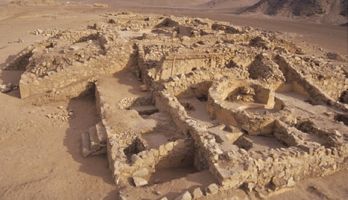
It is interesting that Caral was occupied for approximately one thousand years, and remodeled during those years several times with almost all buildings showing successive periods of occupation. Elements of architectural style, building techniques, materials used, and the color of paint on walls varied during the occupation, but the overall design was maintained as well as the associated cultural traditions and building functions.
It is also interesting to note that the occupatns were apparently a very peaceful people, no trace of warfare has been found at Caral, and no battlements, weapons, mutilated bodies, or defensive fortifications, and no evidence exists of human sacrifice—without fortifications or walls, or anything defensive, archaeologist for the first time realized that people came together in cities not for protection but for growth and development, and warfare had nothing to do with the formation of civilization
The findings of Peruvian anthropologist and archaeologist Ruth Martha Shady Solis (left), who holds the offices of President of ICOMOS-Peru, principal professor and co-ordinator of the master of archaeology graduate program faculty of social sciences of the the University of San Marcos, and director of the special archaeological project Carol-Supe, suggests that the Norte Chico was a gentle society, built on commerce and pleasure.

In addition, cotton seeds were found everywhere in Caral, in every building, at every location, leading to an understanding that cotton was a major crop in their agricultural society. In turn, the textiles were used to trade for seafood from the coast and produce from the interior, the civilization apparently had wide-ranging trade contacts with adjacent settlements.

Evidence suggests that the pyramids were built by stuffing reed bags filled with stones gathered from hillside quarries and riverbanks against a retaining wall. This process was repeated until the mound had reached the desired dimensions and height. Although analysis is not available, the retaining walls appear to be made of random sized stones bonded together with mortar (probably lime and sand). It is interesting that no pottery was found at the site, nor was any art work other than some gourds painted with a figure and the flutes with etched designs.

Considered one of the six sites where civilization originated independently in the ancient world—the six being the Fertile Crescent; Egypt; Asia Minor-Armenia-Iranian Plateau; Indus Valley; Yellow River China; and Norte Chico/Mesoamerica—the Norte Chico were very successful at irrigation-based agriculture. In fact, this region is punctuated with more than 50 rivers that carry Andean snowmelt down to the sea. The development of this widespread irrigation is seen as being decisive in the emergence of population in this region (the same might be said of the population increase in Mesopotamia, where canals were dug between the rivers to aid in agriculture this earlier homeland of the Jaredites and later population expansion known during Lehi’s time.

What is definitely known and uncontestable is that the site of Caral developed centuries before the Olmec arrived in Mesoamerica, making the Andean area of South American the oldest established site in the Americas, with that of Valdivia (see preceding post) older than Caral.


So who built Caral? The Jaredites did not go into the land south right? Isn't Caral too old to be the Mulekites or Lehi's family? Who had 1000 years of peace?
ReplyDelete