
The even more interesting thing is that people insist on supporting and defending ideas that are clearly not consistent with the scriptural record, as though it is some person’s beliefs and ideas that sometimes strays from the truth, accuracy, or reality, and needs the help of modern man to interpret and clarify those mistakes so that today we can better understand what those men who lived at the time in the land they wrote about very clearly and distinctly for us, their future reader.
As an example, Mormon clearly writes about directions of the Land of Promise, using all four cardinal and inordinate directions consistently and understandably, yet along comes John L. Sorenson of the BYU archaeology department to tell us that Mormon really had a totally different meaning to his north, east, south, and west orientation, calling it “Nephite North.”
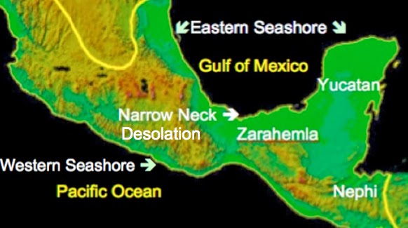
Or along comes Phyllis Carol Olive to show us that instead of her map of the Land of Promise matching the scriptural record, she lists everything out of order with one another in order for it to match her location. In her map below, the large Green Arrow points to her Land Northward, and going south the red arrow to the Narrow Neck of Land, but then the (tan arrow) Land of Desolation, which should be in the Land Northward, she places it in the Land Southward, and from there it gets worse.

Olive's errors occur because she has taken the hill Cumorah and made it the focal point of her map and location, but because it is not the same hill Cumorah as that in the scriptural record, nothing else can be placed in the correct location from each other in relation to it.
Actually, theorist after theorist could be cited here showing their inaccurate portrayal of the Land of Promise that Mormon, who walked and fought across the land from the southern borders of the land of Zarahemla to the northern boundaries of the Land Northward at Cumorah in the Land of Many Waters (Mormon 6:4; compare Mosiah 8:8 with “so far northward” in Alma 22:30), and from the eastern boundary to the West Sea, simply did not, from their point of view, understand his land as well as these modern writers do. When one really considers what they try to tell us, it is almost comical to think that someone today is going to know and understand that land better than those who lived on it and wrote about it.
As an example, Olive wrote about her choosing Cumorah as her starting point: “With nothing more than the Book of Mormon, and the location of Cumorah, we can deduce that Great Lake Erie has to be the “west sea” bordering Nephite and Lamanite lands!” Now, while some may say that sounds reasonable, the scriptural record is not made up of unrelated statements, like the Book of Psalms, where each verses is a separate thought, or maxim, i.e., a short, pithy statement expressing a general truth or rule of conduct. The Book of Mormon is 522 pages of a basic continuous story-line (though Ether is after and not before in the order), briefly covering some 1600 years of the Jaredite kingdom and 1000 years of the Nephite nation. It all takes place on the same basic land (promised land or Land of Promise), as hundreds of generations flow across its pages. In all of that, mostly three men (Nephi, Mormon and Moroni), write about or abridge these events, who describe these interconnecting locations and events quite clearly.
When Nephi tells us he built a ship and sailed across the sea toward the promised land (1 Nephi 18:8) and landed upon the promised land (1 Nephi 18:23), and Jacob tells us “for the Lord has made the sea our path and we are upon an isle of the sea” (2 Nephi 10:20), there is absolutely nothing other than for us to understand that Lehi left in a ship from the area he called Bountiful (1 Nephi 17:5), sailed directly across a sea, which he called Irreantum (1 Nephi 17:5), to the Land of Promise where they landed and settled (on an island in that sea), and that landing spot was along the West Sea in the south “in the land of Nephi, in the place of their fathers' first inheritance, and thus bordering along by the seashore” (Alma 22:28).
Yet despite as clear of an understanding as Nephi and Jacob give us as to the fact that Lehi sailed across the sea and landed on an island of that very sea, which the Nephites later called the West Sea—that West Sea is not inland as Olive writes as though there is absolutely no description like those mentioned above in the scriptural record, and she was free to make it all up, placing her seas where she wanted.

Olive’s comments were based on her belief that the hill Cumorah mentioned in the Book of Mormon is the same hill Cumorah the early Saints called the drumline in western New York, which it is clearly not, especially when trying to compare it with the scriptural record; however, even if it was, her idea of “deduction and best fit” is not acceptable when it goes against Nephi, Jacob, and Mormon’s clear description of where that West Sea was located—and it was not an inland lake with no ship access to the sea over which they sailed as Olive claims, because Jacob tells is it was the same sea over which they sailed.
Not to belabor this type of example, since we have written about this and others like it several times over the past five years, we do need to draw attention to the type of thinking which is misleading at best and quite disingenuous at worst, that ignores clear description of the Land of Promise in favor of someone’s idea of a “best fit” in trying to match a pre-determined land and not the descriptive land of the scriptural record. When one choose a “best fit,” or “best candidate,” or any other example of what or where something was that is not exact, the changes are they will pick and choose an a place that matches their pre-determined area and not necessarily, and often not at all, like the description in the scriptural record.
(See the next post, “The Truth of the Matter – Part II,” for the rest of this very important issue about using the scriptural record to determine where the Jaredite kingdom and the Nephite nation existed and how to recognize that land today)


The book of Mormon would have been written in Hebrew language, if the storyline is to be believed.
ReplyDeleteThe atheists' relentless espousal of the uniformitarianism mindset (and scientism in general) has infected the minds of too many saints. They won't allow that South America could be the site, because they won't/can't bring themselves to doubt "settled" science.
ReplyDeleteIt's the same mindset that won't allow mainstream archeologicalists to re-examine the ancient Egyptian chronology which would result in easily accommodating the Exodus; or that makes evolutionary biologists/neo-darwinists refuse to allow that intelligent design can be a scientific Theory; or that makes geologists completely disallow a global flood, despite the massive evidence being literally EVERYWHERE. The atheists reign, and many of the elect have even unwittingly bought into their lies in the name of "modern science."
ReplyDelete