
Continuing from the previous post regarding the points that Mormon makes in his insert about the geography of the Land of Promise. The first nine were covered in the previous post, here we follow with point number 10:

Again, the Nephites controlled all the Land northward within that “horseshoe” or between the east and west curving wilderness
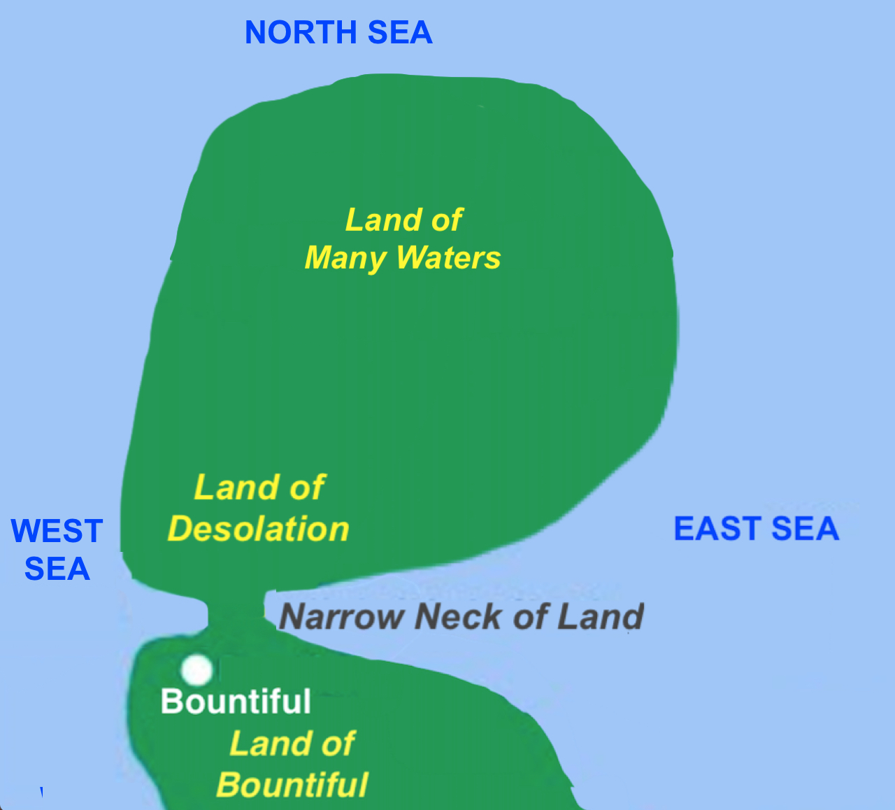
11. This Nephite-occupied area north of the narrow strip began at the head of the Sidon River and ran northward all the way to the Land of Bountiful
The land the Nephites controlled north of the narrow strip of wilderness included all the land other than the east and west wilderness and the narrow strip, which all was filled with idle Lamanites living in tents, especially along the seashores
12. This Land of Bountiful bordered on the north with the southern boundary of the Land of Desolation
Again, the Nephites controlled all the land in the north and Mormon is now describing that land as it passes from the Land Southward (Bountiful) into the Land Northward (Desolation)
The bones belonged to the Jaredites, and Mormon is telling us that the Land of Desolation extended so far northward that it came to the area of many waters, rivers and springs
14. Thus, it being the place of their first landing.
The first landing of the Jaredites, who landed along the seashore and “came up into the south wilderness” or up into the Land of Moron (Ether 7:5)
15. Thus the land on the northward was called Desolation, and the land on the southward was called Bountiful
Along the border between Desolation and Bountiful, and extending in both directions a short distance, was a wilderness—called here, the “south wilderness.” Called the “South Wilderness” because it was in the south of the Land Northward or Jaredite lands
16. This “south wilderness” was filled with all manner of wild animals of every kind, a part of which had come from the land northward for food.
These are the animals described in Ether 9:30-34, specifically vs 32
17. And now, it was only the distance of a day and a half's journey for a Nephite, on the line Bountiful and the land Desolation, from the east to the west sea;
This “line” is the boundary between the Land Northward (Desolaton) and the Land Southward (Bountiful), which is the small or narrow neck of land which is between these two major lands

The Land Southward, or the Land of Zarahemla
and the Land of Nephi were nearly surrounded by water, except for (yellow
circle) the narrow neck of land
18. And thus the land of Nephi and the land of Zarahemla were nearly surrounded by water,
“roundabout” means “not following a direct Mormon is describing the Land Southward, having begun with the king’s proclamation in the Land of Nephi. Thus, he is telling us that this Land Southward was surrounded by water except for this small neck of land in between the two major lands
19. There was a small neck of land between the land northward and the land southward.
This “small” neck of land is the same neck sometimes called “narrow neck” and is the only land form connecting the Land Southward (Bountifujl) with the Land Northward (Desolation)
The point of all of this is to show that all this information, covered here in 19 points, was describing the topography or geography of the Land of Promise, from the far south, where the Lamanites dwelled (even mentioning the area of First Landing), to the far north where the Jaredite final battles took place (Land of Many Waters). All his points, even the mention of the River Sidon, the Jaredite animals that escaped and became wild over time, even the landing area of the Jaredites, etc., was all intended by Mormon to describe the Land of Promise.
Consequently, at this point of a “small neck of land” Mormon is simply continuing with his description of the land and tells us how narrow this narrow neck was so that his future reader could understand what a “small neck” of land meant. And to make sure we understand how narrow it is, or how small this neck was, he tells us what the distance was across this “line” or boundary between the Land of Bountiful and the Land of Desolation, i.e., the distance it would take a Nephite to travel in a day and a half journey.
The word “line” between two lands tells us that this is a boundary. The word “journey” tells us it was a normal movement that was taken (not a race, not a quick or slow passage, just a normal pace). He also tells us in the word “Nephite” that this journey was taken by a normal man that lived in a city style environment as opposed to a Lamanite who lived in the wilderness and sought his food by chasing, trapping and killing animals. Also in using “journey” Mormon tells us that this was a normal movement, i.e., the Nephite would have traveled only in daylight where he could see along this border, and that he rested at times and slept at night.
Now to make sure we understand that Mormon is describing just geography, he goes on in vs 33 to tell us:
20. The Nephites inhabited the land Bountiful, even from the east unto the west sea,
21. The Nephites in their wisdom…had hemmed in the Lamanites on the south, that thereby they should have no more possession on the north, that they might not overrun the land northward.
22. The Lamanites could have no more possessions only in the land of Nephi, and the wilderness round about.
All of this, along with the distance of the narrow neck, was intended to tell us, his future reader, what the Land of Promise was like, how it was configured, and where its size differed considerably, what this distance was. Therefore, from strictly an academic view of this passage (as I see it anyway), this was a distance measurement, it was intended to continue Mormon’s description of the land of which he was describing in some detail, and that he did not vary from his point by inserting unnecessary wordage or thoughts, or ideas that were not clear and easily understood.
After all, what was he measuring in a day and a half journey if not the narrowing of the land where this small neck was situated between the Land Northward (Desolation) and the Land Southward (Bountiful). Nowhere else in his insertion does he introduce an unknown factor in describing the geography of the Land of Promise, and nowhere else does he introduce a distance measurement except where he describes a narrowing (small) are of land.


No comments:
Post a Comment