
Comment #1: “Why do you think Lehi took the course you mentioned from Jerusalem to the Arabian seacoast in Oman? There is a lot of land to the east and south of Jerusalem where they could have gone” Naomi F.

The entire
Arabian Peninsula is a desert with limited water except along the coasts. The
Frankincense Trail followed the water holes and that is where Lehi would have
traveled—or he would have died
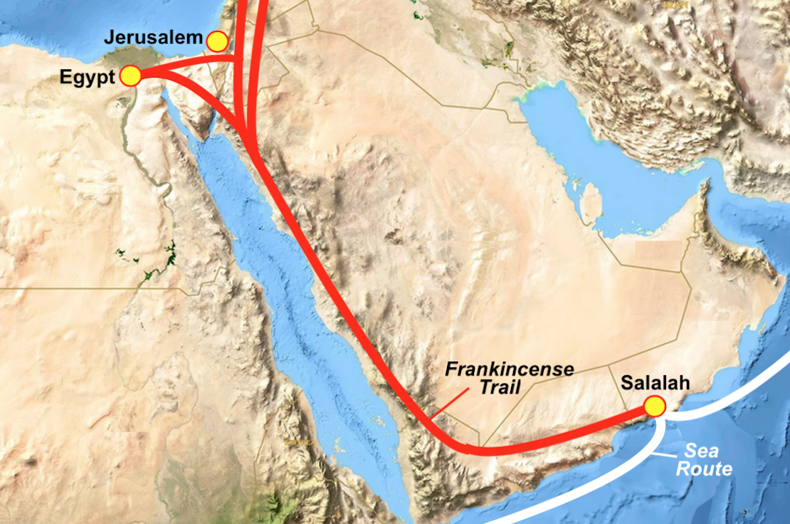
Collectively, these trade routes were known as the Frankincense Trail. The incense trails started from places as diverse as the port at Gaza, the rich spice and incense markets of Damascus in present-day Syria, and ancient Babylon, in what is today Iraq.
These trails eventually ended at one of the major harbors in southern Arabia such as the frankincense harbor at Khor Rori on the coast of Oman. The Frankincense Trail got its name from the primary incense that was transported along it. Myrrh and other incenses and spices were also hauled by caravans along the same trail. In Lehi's time, frankincense grew only in the Dhofar region in southern Arabia; yet, vast amounts of it were used in Egypt, Mesopotamia, Greece, and the temple in Jerusalem. An estimated 3,000 tons were sent to Greece and Rome each year at the peak of the incense trade.
One of the branches of the trail led to Gaza on the Mediterranean and from there to Egypt by another caravan, where it was used to embalm mummies. Frankincense was also exported from Gaza on ships to Greece and Rome, where it was burned in the houses of the nobility and in their temples. The Gaza branch of the Frankincense Trail passed within 10 miles of the Valley of Lemuel, and we presume that it would have been known to Lehi.
A settlement
near the city of Salalah in southern Oman was once a key hub in an ancient
trading network across the Arabian Peninsula, with branches into Egypt, moving
for incense and spice along these trading routes
These Frankincense trails were all interconnected and the main trail southward along the Red Sea and then eastward across the Empty Quarter was the only route available to Lehi and his family as they headed for the Sea of Arabia.
Comment #2: “In the article you wrote about malaria in Rome, I have read where most archaeologists have disagreed with that theory and marginalized David Soren’s work on the children of Lugnano” Carlo S.
Response: It is a long story and was not the main issue of our article, therefore, we did not delve into it enough to relate to your comment and the criticism directed at Soren. However, after many years of David Soren being a laughing stock in the archaeological world, in the late 1990s a British scientist, Robert Sallares, a DNA expert based UMIST (University of Manchester, Institute of Science and Technology), confirmed Sorens work.
He was particularly interested in using the latest DNA techniques to identify diseases of the past. His main problem was finding bones that might be associated with a particular disease. There was no point in looking randomly at bones from the past, he needed to know that there was a good chance that the person had died of a particular disease. However, for the first time there was a forensic technique that would give cast-iron evidence—but at first, Sallares was unable to find suitable bones, but when he read about Soren's work, he approached him about doing DNA tests. Soren jumped at the opportunity. Not only did Robert Sallares take his theory seriously, but now, for the first time, there was a forensic technique that would give cast-iron evidence either way as to the presence of malaria (once called Roman Fever). Sallares and his team painstakingly analized the bones, searching for the tell-tale DNA traces of the disease. The first four results all came up negative. It was not until Sallares tried the fifth and last bone samples that he finally came up with a positive result. He was able to show the presence of malarial DNA in the leg bones of a three-year-old girl. Because of the way malaria spreads, this particular malaria was most likely part of an epidemic sweeping through a region of Italy (Robert Sallares, Malaria and Rome: a History of Malaria in Ancient Italy, Oxford University Press, 2002).

Monument to Dr. Robert
Sallares
The DNA work of Robert Sallares has now confirmed that malaria was a killer during late Roman times. The children of Lugnano died of malaria, and it is likely that there were also many adult victims of the disease, although their cemetery has not yet been found. This would have made it difficult for farmers to collect crops and for the local army commanders to raise troops. What was once a footnote in the history books on the fall of Rome, must now become a whole chapter. David Soren's theory that malaria contributed to the fall of Rome has finally been vindicated.
Comment #3: “When did the Panama Isthmus rise up to connect South America and Central America? I've been assuming it would have been at the death of Christ with the rising of the Andes? But it could not have been until after the last battle of Cumorah or the Nephites would have fled northward as you have pointed out on a couple posts” David K.
Response: I have written about this at least twice in the blog in greater detail with pictures, etc., but briefly, what is called “the Panama knot,” came up at the time of Christ's crucifixion, with all the other turmoil that struck the Land of Promise; however, unlike other areas, such as Mesoamerica which has free passage to the north and south, the land to the north of the Land of Promise (Colombia to Panama), is all high mountains—consequently, for the Pan American highway, and north south movement through these mountains, they had to dig tunnels and extremely dangerous mountain roads just to get to the Gap, yet even today, there is almost no way through the Gap yet established because of its extreme difficulty, certainly impossible for families or even the average person.

A map of the area north of the Land of Promise, i.e., today’s country
of Colombia showing the various mountain ranges stretching across any path from
Peru northward through Colombia toward Panama
In modern times, roads were made to go over the mountains, such as the 45-mile-long North Yungas Road, which today is by far the most dangerous on the planet with its 10-foot wide path and 2700-foot sheer cliff drop. It is so dangerous that it has earned the epithet of “Death Road.” Built in the 1930s, the journey from the high mountain plains, through the steep cliffs and hillsides down through the rainforest is the most dangerous on earth and before it was built, no one could traverse this area to the Darien Gap.
When they build the Pan American highway, which stops in Panama and in Colombia, leaving no road through the Gap, many people died trying to pass along the surface roads until they built the huge tunnel system in 2005, which allows for the first time passage from Colombia to Panama.
To the north of these mountains is the Isthmus of Darien, an area that even with specially equipped 4-wheelers, has only once been penetrated from north to south by anyone in any capacity, though numerous groups and expeditions have tried.
Even if Mormon knew about this extension or connection to the north, it would have proven impossible to cross, certainly not with women and children. Thus, the Nephites were boxed in. Only airplanes could fly over the Andes to the east for many years until a road was finally built. In fact, people along that western shelf of the Andes to the sea have called the area an island for its entire existence because there was no way to go east or north until 1) airplanes were used (Jorge Chavez, a Peruvian aviator born in France, tragically died after he successfully air crossed the Alpes by air in 1910, crashing upon landing. Alejandro Velasco Astete, a Peruvian pilot, is well known for being the first man to fly over the Andes in 1925; 2) a railroad was built; and 3) finally the Interoceanic Highway (Transoceanic highway), an international, transcontinental highway in Peru and Brazil resulting from an agreement of the two countries signed in 2004, and the project, known as MTC (Ministerio de Transportes y Comunicaciones) opened in 2005 to 2007.


I don't understand why people continue to ask... "Why did Lehi take THAT path when he could have gone another way?" How quickly people forget. Maybe instead of reading the scripture over and over again... a quick video will tell you all you need to know:
ReplyDeletehttps://drive.google.com/open?id=1nNQ4qQB68zDRGXDM6AGubGQeB0bTSw9c
Well done NrNirom. That hits it on the head. They went that way because the Lord told them to through the Liahona. The end.
ReplyDeleteI guess then one would have to change the question to - why did the Lord have them go that way instead of a different way. Del has answered that above.