Wednesday, March 13, 2019

What Was Meant by the Narrow Strip of Wilderness? – Part I

There are numerous references to this narrow strip of wilderness first mentioned by Mormon in his inserted geographical description of the land in Alma 22. But it is also referenced in other areas by other descriptive terms, such as “the wilderness at the head of the river Sidon” (Alma 22:29); “the wilderness which divided the land of Nephi from the land of Zarahemla” (Alma 27:14; “the line between the Nephites and the Lamanites” and “the line between the land of Zarahemla and the land of Nephi” (Alma 50:11); “the line of the possessions of the Lamanites” (Alma 50:13); and “the mountainous barrier people crossed over “ (Alma 25:2, 27:14).
    Mormon, inserting into the record a lengthy statement about the geographical setting of the Land of Promise, described the Land of Nephi over which the Lamanite King ruled, as “all of the land in all the regions round about…bordering even to the sea, on the east and on the west, and which was divided from the land of Zarahemla by a narrow strip of wilderness, which ran from the sea east even to the sea west, and roundabout on the borders of the seashore, and the borders of the wilderness which was on the north by the land of Zarahemla…thus were the Lamanites and the Nephites divided” (Alma 22:27).
To understand one descriptive reference, sometimes it has to be compared with a second reference

Mormon later stated that “the land of Nephi did run in a straight course from the east sea to the west” (Alma 50:8). In this case, since his earlier comment said the narrow strip ran from sea to sea, then in this latter statement, Mormon used elliptical writing, leaving out the word “sea” but meaning “to the west sea.”
    In looking at the term “straight course,” it is only found five times in the entire Book of Mormon, in two of the four uses in Alma, and the one time in 2 Nephi, it has to do with pointing toward a straight course to eternal bliss; following in a straight course; and on the narrow path. In one case in Alma, it is used relating to the Liahona pointing a straight course for Lehi to the promised land. The only use of “straight course” dealing with a border, is one in Alma saying the Land of Nephi did run in a “straight course” from the east sea to the west” (Alma 50:8). This is also born out when Mormon states: “fortifying the line between the Nephites and the Lamanties, between the land of Zarahemla nd the land of Nephi, from the west sea” (Alma 50:11).
    In a typical theorist statement, in trying to prove their Land of Promise model, one such theorist stated: “Straight course means a direct line from one point to another, without encountering an obstruction, or being diverted. Having the same direction its entire length, undeviating, uninterrupted, unswerving, without detour, extending continuously, without detour.” While this might be found in some modern dictionary, though we have not run across it, the meaning in Joseph smith’s time when he translated that Nephite phrase into English, the term meant:
Straight: “direct; passing from one point to another by the nearest course; not deviating or crooked; as a straight line; a straight course,” and
Course: “a passing; a moving, or motion forward, in a direct or curving line.”
    To better understand this meaning, we need to see what Alma also wrote about a “straight course” when he said about people and their need to “give heed to the word of Christ, which will point to you a straight course to eternal bliss, as it was for our fathers to give heed to this compass, which would point unto them a straight course to the promised land” (Alma 37:44, emphasis added).
    Now the meaning of this is plain and simple, for when Lehi used the Liahona to point their direction from the Gulf of Aqaba along the Red Sea and to what he named Bountiful, they went “in a south-southeast direction (1 Nephi 16:13), but then later they “did travel nearly eastward from the time forth” (1 Nephi 17:1). Then later, in Nephi’s ship, where he used the Liahona for direction, they went southward in the Indian Ocean, and then turned eastward across the Pacific, or as some theorists try to convince us, they turned westward and then northward across the Atlantic; however, in either case, the course was not straight in an undeviating direction
Lehi’s “straight course” to Bountiful involved at least three specific compass changes in direction

Thus, in both Lehi’s direction to Bountiful, and the ship voyage to the Land of Promise, the course deviated, that is the “straight course” changed and was not “a direct line from one point to another, without encountering an obstruction, or being diverted,” yet it was called a “straight course” according to Mormon’s description of that sea voyage to the Land of Promise.
    Thus, when we try to decipher or understand a scriptural meaning, we need to compare its meaning in multiple uses to come up with an overall meaning that applies to each use.
    As an example, in “Behold, the way for man is narrow, but it lieth in a straight course before him“ (2 Nephi 9:41), and in “give heed to the word of Christ, which will point to you a straight course to eternal bliss” (Alma 37:44), shows that for a person to achieve a goal, one must follow a “straight course” toward it, that is, not to lose focus or not to be preoccupied with other matters, problems, desires, temptations, that would move one away from the goal.
    In another instance, the term “straight course” is used in the description of the Lamanites pursuing Antipus and his men, the Lamanites “did not turn to the right nor to the left, but pursued their march in a straight course after us” (Alma 56:37). In each of these cases, the intent of the phrase is obvious—they were not sidetracked away from reaching their goal or objective. It is not a matter of moving in a perfect straight line—but with a singleness of mind and intent toward the objective.
The Narrow Strip of Wilderness as described by Mormon (Alma 22:27)

As to better understanding the narrow strip of wilderness Mormon describes, certain factors are given us, and if we intend to try and locate such a landmark in the Land of Promise, now or in the past, all of Mormon’s descriptions must apply to the area we locate. In using the 1828 American Dictionary of the English Language, the dictionary Joseph Smith chose for his School of the Prophets, and therefore the language known to Joseph in his translation, we can also better understand the meaning of his translation of Mormon.
1. Dividing Line or Border. The Land of Nephi “was divided from the land of Zarahemla by a narrow strip of wilderness” (Alma 22:27). That is, the narrow strip ran between the Land of Zarahemla (which was to the north) and the Land of Nephi (which was to the south). Thus the narrow strip acted as a northern border for the Land of Nephi and a southern border for the Land of Zarahemla.
2. From sea to sea. The “narrow strip of wilderness which ran from the sea east even to the sea west” (Alma 22:27). Thus, any narrow strip has to extend from an ocean on the east to an ocean on the west. This means that the Land of Nephi, and the overall land of Zarahemla stretched from an ocean to the east to an ocean to the west, being nearly surrounded by water (Alma 22:32).
3. West and East. The narrow strip “ran from the sea east even to the sea west” (Alma 22:27). The West Sea, then, was located west of the land of Nephi, west of the land of Zarahemla, and west of the western end of the narrow strip of wilderness (Alma 22:28). In addition, the East Sea was located east of the land of Nephi, east of the land of Zarahemla, and east of the eastern end of the narrow strip of wilderness (Alma 22:27-29). It should also be noted that “the Nephites had inhabited the land Bountiful, even from the east unto the west sea” (Alma 22:33), which hemmed in the Lamanites on the south so they could not overrun the Land Northward, and could have no more possessions north of the narrow strip of wilderness (Alma 22:33-34). This means there was no land in the Land of Promise to the east of the East Sea or west of the West Sea, they being the boundaries of the Land Southward.
(See the next post, “What Was Meant by the Narrow Strip of Wilderness? – Part II,” regarding where it was located, what purpose it served, and how the Nephites used it as a line of defense)

Tuesday, March 12, 2019

Why Do We Keep Claiming the Hill in New York is the Hill Cumorah of the Book of Mormon? – Part II

Continued from the previous post, regarding the effort of artifact hunters and official records of the area in Western New York in determining what has been found around the New York hill Cumorah.
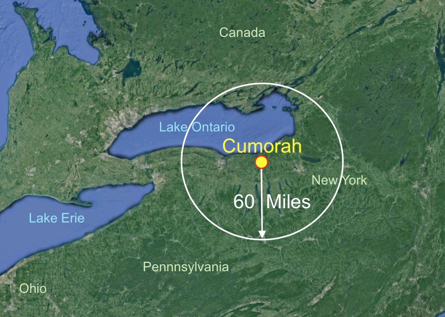
No artifact sites have officially been authenticated (white circle) within 60 miles of the hill Cumorah in New York
 
As mentioned in closing the previous article, the nearest site found and officially listed in the State of New York records for ancient indigenous artifacts is sixty miles away from Palmyra. Now sixty miles away from the hill Cumorah for the only location of ancient artifacts found in New York and authenticated by the State of actual ancient artifacts should suggest to even the most skeptical that a battle of the magnitude of that fought between 230,000 or more Nephites and a much larger Lamanite force (Mormon 6:8), which probably numbered close to 350,000 or more, is simply out of the question. Consequently, a war involving around 500,000 warriors or more, with at least 230,000 Nephites being killed and likely a third of that number of Lamanites being killed, or a total of about 300,000 dead, with arrows flying, spears thrown, clubs dropped in death, stone or metal tomahawks embedded in skulls, rocks from slings, etc., used by the thousands, one would expect a large number of artifacts being found there—and many by those searching for them from groups and organizations whose work it was to find such articles and relics.
    However, despite all in that area who had been searching for such finds throughout all of New England, but especially from Vermont to Western New York, nothing closer than 60 miles to the hill Cumorah in Palmyra has ever been authenticated. After all, wherever early American sites are, collectors will find them, plowed fields being the best place to look—and the land around the hill Cumorah, and on the hill, has been the site of numerous plowed fields over the centuries since the early colonial period, with hundreds upon hundreds of acres being plowed and ready for planting, and crops grown since the first settlement in 1624, and the English takeover of the complete New York area in 1664.
    Consequently, in more than 300 years, no artifacts have been authenticated in and around Palmyra, the hill Cumorah, or major finds closer than sixty miles away, despite some theorists’ claims to the contrary.
    So why do we keep hearing people claim the hill in New York known in the early years as “Mormon Hill,” “Gold Bible Hill,” “Inspiration Point,” and later called by early Church members “Cumorah,” is the same hill found in the scriptural record of the Book of Mormon where some 300,000 or more people died in a final battle?
    As Landon Smith wrote about visiting the hill Cumorah in Palmyra: “I have made the seven-hour drive twice in the past few years. Both times I traveled to Palmyra during the early planting season—fields just plowed and harrowed, following a good rain to wash the dirt off any artifacts. There are some areas that are not plowed and cannot easily be hunted, including the seating area west of the hill and the car parking area on the west side of the highway. North of the hill there is a gully going west to east with trees growing along it, circling from west of the road past the north end of the hill to the east side. Along the whole east side of the hill is a large plowed field. To the north of the gully with trees is the farm that is owned by the Clark family. They have several plowed fields in the area.”
Oliver Cowdery’s West Valley battlefield, a rectangular area about a mile or two square in which 500,000 warriors could not have conducted a battle

Now, while apologists for the Heartland theory like to claim that Oliver Cowdery in Letter VII said the entire battle was fought in the west valley, or the valley west of the hill, it should be noted that Mormon places the Nephites surrounding the hill when he wrote: “we did march forth to the land of Cumorah, and we did pitch our tents around about the hill Cumorah” (Mormon 6:4).
    The idea, as these Heartland theorists claim, that since the entire battle was fought in the west valley, that there would be no artifacts in the north and east of the hill, seem to forget that not only did the Nephite encampment of their 230,000 warriors, wives and children surround the hill, but that they were all aware of the approaching Lamanites and all had the same feeling of being overwhelmed, with death staring them in the face. Consider: “And it came to pass that my people, with their wives and their children, did now behold the armies of the Lamanites marching towards them; and with that awful fear of death which fills the breasts of all the wicked, did they await to receive them” (Mormon 6:7). And immediately, without fanfare, without palavering, without any assemblage, they attacked.
    “And it came to pass that they came to battle against us, and every soul was filled with terror because of the greatness of their numbers…and they did fall upon my people with the sword, and with the bow, and with the arrow, and with the ax, and with all manner of weapons of war” (Mormon 6:8-9).
    Landon Smith goes on in his letter: “Arriving at Cumorah, I have asked workers on the grounds around the visitors' center and people inside the center about arrowheads. Their comments were:
"Oh yes, people find them around here all the time."
I would then ask, "Have you found any yourself?"
"Well, no."
"Do you know anyone who has found some?"
"No."
"Have you seen any actual pieces found by others?"
"No."
I have walked to the big meadow east of the hill. I have searched it thoroughly. I was thinking, "There have to be remains here, but where?" No artifacts—not even flint chips of any kind. So I went north to the Clark farm. I stopped and asked the owner's wife if I could walk over the corn field.
"What are you looking for?"
"Looking for arrowheads—is it okay?"
"Well, sure."
"You must get pestered a lot by people wanting to go out there looking around."
"We've been here over 40 years, and you're the first to come and ask to hunt for arrowheads."
Collectors of relics generally can find artifacts just by walking through wilderness areas, especially where known routes of the ancients are located

If there are artifacts out there, collectors will find them, and they and their friends will be all over that area. However, as Landon continued: “The Clarks' fields yielded the same as the one east of the hill: not one single arrowhead and not one single piece of flint chipping. Crisscrossing all those plowed fields, which are hundreds of acres, I found no evidence of any kind. If a large group of people came to this hill and had a big battle, they would have been making and sharpening more tools—artifacts. If there are no arrowheads, what about all of the broken pieces, the chips, the flakes—leftovers from making and sharpening? Some of these pieces would be smaller than a little fingernail. Where are these pieces? People do not generally pick up that kind of trash.”
    However, as Landon shows, not a single piece has been found. He adds, “Since I had the experience of searching and finding sites, my interest in finding sites of possible Nephit-Lamanite arrowheads was high. There were also stories of how Brother Willard Bean found arrowheads by the basketful around the hill and sold them to tourists. If battles took place at the hill, and a lot of people took part—everything sounds about right—the area should be covered with all kinds of artifacts.”
    But it was not then, not now, evidently not ever, for such numbers of artifacts always leave traces, other pieces being plowed up, moved toward the surface from underground and soil activity. Having been arrowhead hunting in the wilderness of central and southern Utah, a person with a keen eye can still find arrowheads just lying on the ground. We have seen cases where several of us walked right over several arrowheads without seeing them, but one among us with a background in arrowhead hunting, saw them all.
Lastly, Landon Smith finished his letter by commenting that J. Sheldon Fisher, who lived in the small town of Fishers, about 10 miles southwest of the hill Cumorah owned what he called the Valentown Museum, which was full of American artifacts and all types of antiques. Not only was he a great historian of the happenings down through time in that area, he supplied most of the early-1800s furniture used in the area's visitors' centers. He worked as a professional archaeologist for the state of New York for over 30 years. In fact, an article in the March 3, 2001 Church News, covered his finds of an old Brigham Young home (Shaun D. Stahle, "Excavating Brigham Young's mill site").
    Landon says of him: “He said that he had a standing agreement with all of the bulldozer and backhoe people in the county that they would call him when they were about to start jobs in the area. Many times, he said, "I'd beat them to the site—I'd get there before they would." He always watched the soil as they dug it or pushed it around. But he never found any artifacts of any kind. I have spent evenings on both trips to Palmyra talking with him about the area and its history. His comment on my last trip was, "Oh, I hope this doesn't shake your faith." I answered, "No, it doesn't. The Church is still true. The Book of Mormon is true. And those plates came out of that hill. The battle—well, it must have been at some other hill.”
    So once again, we ask “Why do we keep hearing people claim that the hill in New York known in the early years as “Mormon Hill,” “Gold Bible Hill,” “Inspiration Point,” and later called by early Church members “Cumorah,” is the same hill found in the scriptural record of the Book of Mormon where some 300,000 or more people died in a final battle, and not a single authenticated artifact has ever been found there.

Monday, March 11, 2019

Why Do We Keep Claiming the Hill in New York is the Hill Cumorah of the Book of Mormon? – Part I

In a recent 2012 article published by Phil Michel, under the title: “Archaeological and Historical evidence of the Hill Cumorah in the State of New York,” the following was the lead paragraph, claiming to quote Joseph Smith: “This hill located "convenient to the village of Manchester, Ontario county, New York" and is now called in our day "The Hill Cumorah" (Joseph Smith-History 1:51).
    Note that the author claims Joseph Smith said of the New York Hill “and is now called in our day “the Hill Cumorah,” and then provided the reference of the History 1:51, as though to evidence Joseph called the hill in New York the Hill Cumorah. However, it should be noted that no such reference is made by Joseph in his history.
    In the actual written History of Joseph Smith, first published under the title History of the Church, and nicknamed Documentary History of the Church or DHC, which was largely written during Joseph Smith’s lifetime and composed of Joseph’s writings and interpolations and editorial comments, beginning in 1839. In section 1:51, which the author of the article referenced to this comment, the actual statement is:
The hill in Manchester, New York is large in comparison to the few other low-lying hills in the area, but is not actually very large

“Convenient to the village of Manchester, Ontario county, New York, stands a hill of considerable size, and the most elevated of any in the neighborhood. On the west side of this hill, not far from the top, under a stone of considerable size, lay the plates, deposited in a stone box. This stone was thick and rounding in the middle on the upper side, and thinner towards the edges, so that the middle part of it was visible above the ground, but the edge all around was covered with earth” (emphasis added).
    Note there is no mention of the word “Cumorah,” let alone the words “and is now called in our day…” Yet, “the hill” is mentioned twice—surely, if Joseph thought of it having a name, that name would have properly been inserted to reference the hill itself. But no name was given by Joseph in his writing, though the author of the article claimed he had.
    Such is the misleading writing of people who want to make a point and feel they can fudge on the facts of the matter, and give a real reference to back up their claim. After all, most authors know that few people check the references they write down. In our book “Inaccuracies of Mesoamerican and Other Theorists,” we list and detail in several hundred pages the inaccurate statements attributed to scriptural references in the Book of Mormon by John L. Sorenson, the past BYU Archaeology Department head and guru of Book of Mormon Land of Promise archaeology, as well as several other writers of Book of Mormon geography. The point is, claiming a reference to support an article that does not say what is being claimed is not only erroneous and very poor scholarship, it is downright misleading, deceptive and spurious.
    In addition to the lack of reference to a hill Cumorah by Joseph Smith, he also stated in the preceding paragraph: “I obeyed; I returned to my father in the field, and rehearsed the whole matter to him. He replied to me that it was of God, and told me to go and do as commanded by the messenger. I left the field, and went to the place where the messenger had told me the plates were deposited; and owing to the distinctness of the vision which I had had concerning it, I knew the place the instant that I arrived there” (Hisotry 1:50, emphasis added).
    Again, there were two more incidents where Joseph could have, and appropriately so, inserted the words “hill Cumorah” for specific referencing, but did not. It would seem from these two paragraphs of his History, that the word “Cumorah” was either not known to him at the time, or he did not associated such a name to the hill in New York.
In addition, Joseph wrote two additional instances where he could have appropriately used the name “hill Cumorah,” but did not: “The messenger…told me that I should come to that place precisely in one year from that time, and that he would there meet with me, and that I should continue to do so until the time should come for obtaining the plates.
    Accordingly, as I had been commanded, I went at the end of each year, and at each time I found the same messenger there, and received instruction and intelligence from him at each of our interviews, respecting what the Lord was going to do, and how and in what manner his kingdom was to be conducted in the last days” (History 1:53–54).
    It seems really strange that Joseph did not place a name on the hill, calling it “that place” and “there,” when a name would have been far more clear. And in another instance above, did not even refer to the hill at all saying only “I went at the end of each year.” It would also appear from this, that Moroni did not call the hill “Cumorah,” but simply “that” or “this place.”
    Again, in another instance and the final reference to the hill, Joseph wrote: “At length the time arrived for obtaining the plates, the Urim and Thummim, and the breastplate. On the twenty-second day of September, one thousand eight hundred and twenty-seven, having gone as usual at the end of another year to the place where they were deposited, the same heavenly messenger delivered them up to me with this charge: that I should be responsible for them; that if I should let them go carelessly, or through any neglect of mine, I should be cut off; but that if I would use all my endeavors to preserve them, until he, the messenger, should call for them, they should be protected” (History 1:59).
    Since this information was written in 1839 or later, 16 years after the initial meeting with Moroni, and several years after Oliver Cowdery first used the term “hill Cumorah” and other members began calling it the “hill Cumorah,” Joseph still did not refer to it as such, calling it only “the hill,” “the place,” “that hill,” etc.
The entire area around the hill in New York has been searched for artifacts, except for the (red circle) parking area and Visitor’s Center and seating area for the Pageant—no artifacts have been found

As for the hill itself, which Oliver Cowdery claimed was where the final battle that resulted in around 300,000 deaths took place in the valley in New York at the foot of the hill now called Hill Cumorah, it should be of interest that no authenticated artifacts have ever been found there. In fact, the entire archaeological record of New York does not support the idea the Book of Mormon peoples lived in that region or that the hill was the scene of the final battles between the Nephites and the Lamanites.
    In fact, according to the Vermont Archaeology Heritage Center at Barre, in central Vermont, which serves as the central repository for the artifacts and archives of Vermont’s unwritten past, there are over 800 known archaeological sites, with compliance reports, artifacts, and associated material available for study to qualified researchers, with more collections being accessioned regularly. A researcher of artifacts in New Haven, Vermont, named Landon Smith, who had investigated most every site in the New England area, including the fields surrounding the Hill Cumorah, near Palmyra in New York, wrote to BYU in 2005, regarding an article John E. Clark, professor of anthropology at BYU wrote entitled “Archaeology and Cumorah Questions,” in 2004.
    Landon Smith stated in his letter by way of introduction that he had been searching for native American sites in Vermont for several years, and “By myself I have found over 378 new Native American sites, obtaining Vermont State site numbers for all of them. I have made out all the required survey forms and sent the relevant information to the state offices. At this time, I have close to 5,000 arrowheads with all the other tools—bifaces, preforms, knives, scrapers, and so on. Altogether I have 17,000 pieces. Each piece has been traced, with the site number and catalog numbers painted on. Maps are made of each site with X marks locating where each piece was found.”
    Landon went on in his letter to talk about working with the State and having access to items, maps, etc., stating: “I get to see things that I'm probably not supposed to see—like a New York State site map. Around Syracuse and the areas in eastern New York State there are many sites recorded, as there are around and south of Rochester in western New York. But around the Hill Cumorah area, the closest site numbers are about 60 miles away.”
(See the nest post, “Why Do We Keep Claiming the Hill in New York is the Hill Cumorah of the Book of Mormon? – Part II,” regarding the effort of artifact hunters and official records of the area in Western New York in determining what has been found around the New York hill Cumorah)

Sunday, March 10, 2019

Ecuadorian Cultures Existing at the Time of the Jaredites – Part II

Continued from the previous post, regarding the development and historic events in Ecuador at the time of the Jaredites, and later the Nephites.
    In this northward land, the Jaredites both landed and settled, spending some 1500 years or more in the area, never going south into what was known to the Nephites as the Land Southward. However, “the whole face of the land northward was covered with inhabitants” (Ether 10:21), and with animals of the forest (Ether 10:19), and in the final stage of the Jaredite kingdom, “the whole face of the land was covered with the bodies of the dead” (Ether 14:21).
The Santa Elena Peninsula where the strong currents moving up the coast from the south bend outward into the South Pacific Gyre while coastal currents bring flotsam and wind-driven vessels into shore

The early Jaredites, under the direction of Jared and his brother, landed along the west coast about 4100 years ago. In Valdivian history, the Valdiva had trade routes along the Pacific coast and over the cordilleras to Peru and back to the Amazon. The Jaredites, on the other hand, went south of the narrow neck (into Peru) to hunt for game in the preserve they set aside for “a wilderness to get game” (Ether 10:21).
    The benign climate of the Ecuadorian coastal regions provided abundant food supplies and the absence of outside enemies and diseases enabled the Valdivians to stabilize and prosper without interference for millennia. This coincides with the fact that the Jaredites had no outside enemies—none had inhabited the land before their arrival. This is reinforced in the fact that, “after the waters had receded from off the face of this land it became a choice land above all other lands, a chosen land of the Lord; wherefore the Lord would have that all men should serve him who dwell upon the face thereof… Wherefore, the remnant of the house of Joseph shall be built upon this land; and it shall be a land of their inheritance; and they shall build up a holy city unto the Lord, like unto the Jerusalem of old; and they shall no more be confounded, until the end come when the earth shall pass away” (Ether 13:2,13).
    Thus, in archaeological findings, there was no evidence of any wars or intrusions from other tribes during the Validivian period, a quite different history than most other cultures and civilizations in other parts of the world. From the beginning the Valdivians were oriented to the sea, and being active merchants, the Valdivians were masters of deep-sea navigation. There is substantial evidence that the Valdivians traded with Central America and Southern Mexico via the Galapagos Islands. On land, their trade empire ranged throughout the land, to Northern Ecuador, as well as from the Pacific coast into the deep reaches of the eastern lands, where they traded their maritime goods, such as Spondylus and conches, for non-perishable goods like sodalite and turquoise.
Spondylus regius - Royal or Regal Thorny or Spny Oyster (though they are not oysters); they were known in the Aegean Sea and along the coast of Colombia and Ecuador. They were found as late a the Moche period in Andean art

The Spondylus shell often found as deep as 160 feet in the ocean and most abundant in equatorial waters, was introduced to inland areas since it was the most sought after trade item in America, and was the case in all the Americas until the arrival of the Spaniards in the XV century.
    Direct evidence of this inland trade is difficult to trace, because the main routes and settlements in the valleys of the Andes have been covered several times in the last millennia by eruptions of the more than 80 active volcanoes in northern Ecuador and southern Colombia. For example, villages in the highlands west of Quito were covered twice by a one-meter thick ash flow from the nearby Pululahua volcano in 1500 BC and 450 BC.
    Archeologists have divided the cultural development during the Valdivian history into phases, beginning with their villages along the coastal plateau. The second major phase was in the Valdivians establishing a large number of satellite villages in various parts of Ecuador and apparently in southern Colombia. In the final stage, during the last hundred years of the Valdivias, their way of life changed drastically until they disappeared from the archaeological record.
    The Valdivian civilization distinguished itself in America as being among the first dedicated to agriculture with stable villages and ceremonial centers involving several hundred families, and for establishing trade routes throughout the northern areas. They also created ceramics, which quality equaled the finest in other continents of the same epoch and 1,500 years earlier than in Mesoamerica or Peru; however, they were similar to ceramics that later showed up among the Mayas, Aztecs and Inca.
    As stated earlier, long-time Valdivian researchers are amazed at the anthropological and archaeological claims that the Valdivia had a lengthy history in Ecuador of development similar to other cultures in, reaching back many millennia when, in fact, they claim when the Valdivia arrived, they did not share a common origin and that they simply popped up out of nowhere with capabilities rivaling those of the Old World.
    The Valdivians had advanced techniques in aquaculture, the construction of dams, water channels and complex water reservoirs. A major effort and influence of the Valdivia seems to be based on a cult for water. However, it seems clear among the professionals who work in these areas of ancient Cultures, that the Valdivians were the mother culture of the Americas. There is much evidence to support that their symbolic, pictographic art may have been a proto-writing system. These symbols used systematically by the Valdivians developed into a pictographic writing system, as is evidenced by the stone plates and ceramic bowls of what the anthropologists call the Final Valdivian Phase.
Three other cultures and cultural development in four additional provinces followed the origin of the Valdivian Culture; and the location of the Mayo-Chinchipe Culture in southern Ecuador

According to archaeologists, several other cultures, including the Quitus, Caras, and Cañaris, emerged in other parts of Ecuador. There were other major archaeological sites in the coastal provinces of Manabí and Esmeraldas, as well as in the middle Andean highland provinces of Tungurahua and Chimborazo. The archaeological evidence has established that Ecuador was inhabited for at least 4,500 years. However, great tracts of Ecuador, including almost all of the Oriente remain unknown to archaeologists, a fact that adds credence to the possibility of early human habitation. Scholars have studied the Amazon region recently but the forest is so remote and dense that it takes years for research teams to survey even a small area. Their belief that the river basin had complex cultures is confirmed by the recent discovery in 2002 of the Mayo-Chinchipe Cultural Complex in the Zamora-Chinchipe Province, believed to be the oldest people of the eastern Andes area. The presence of the Strombus and Spondylus sea conch shells found in the eastern slopes, now covered by jungle, shows the people had dealings with those on the coast.
    Ecuador is presently at the heart of the region where a variety of civilizations developed for millennia. During the pre-Inca period people lived in clans, which formed great tribes, and some allied with each other to form powerful confederations, as the Confederation of Quito. But none of these confederations could resist the formidable invasion of the Inca in the 15th century, which was both painful and bloody. However, once occupied by the Quito hosts of Huayna Capac, the Incas developed an extensive administration and began the colonization of the region.
The location of Zamaora-Chinchipe is located along the coast in the province of Manabí, where a complex of accessible ruins have been dated back to two periods—1800 BC to about 1300 BC, and another from 500 BC to about 500 AD

In an area just north of the Santa Elena Peninsula, called today by archaeologists Solango, an ancient coastal development and coral reef island off the coast, was first occupied by the Valdivia culture from 1800 to 1330 BC, and then later by what archaeologists call the Mayo-Chinchipe Culture, which occupied the area from about 500 BC to about 500 AD, where a platform ceremonial center was located and a large structural complex. Archaeological evidence recovered by the Programa de Antropología para el Ecuador at the Salango site on the south coast of the Province of Manabí between 1979 and 1989, emphasized that the need for a full description, analysis and publication was not only desirable but, from social, as well as cultural, scientific and historical perspectives, quite necessary.
    When the first clay walls and tombs of the funerary precinct were discovered in 1982, there was no existing account then published of any excavation of ceremonial architecture of the relevant period for the Ecuadorian western lowlands. Since then, except for the results of the limited work at Salango, the situation has stayed basically unchanged. To this day, little has been done to further the study of this area.
    On the other hand, the dates are basically similar to the Jaredite occupation of this land to the north, and a much later occupation of it by another group, such as the Nephites, that moved into this northern land. This latter culture thrived from about 100 AD onward, during a period of integration of various settlements in which they built better housing that allowed them to improve their living conditions, and in the mountains they also flourished as well as in the eastern regions.

Saturday, March 9, 2019

Ecuadorian Cultures Existing at the Time of the Jaredites – Part I

The history of Ecuador is better known from the time of the Inca Empire, when it expanded into Ecuador, than is known of the Pre-Columbian era. In fact, even after the Inca conquered Ecuador many historical gaps—great gaps in history that most archaeologists and anthropologists are uncomfortable discussing (Alexander Hirtz, “The Mother civilization of the Americas,” Cosmology of the Valdivians, Shanghai, 2010)).
    These gaps, of course, remain because of the limited recorded history the Valdia and later the Inca kept. In 1463 the Inca warrior Pachacuti and his son Topa Yupanqui began their conquest of the North—what is today known as Ecuador. By the end of 15th century, despite fierce resistance by several Ecuadorian tribes, Huayna Capac, Topa Yupanqui’s son, conquered all of Ecuador.
The unconquered areas, free from Incan and Spanish invasion
However, their time in Ecuador was limited, for by mid-1534, the Spanish had taken Quito and effectively defeated the Inca armies, marking the end of serious resistance in the Andean north, in Ecuador. Weakened by civil war and leaderless, the Inca empire collapsed swiftly; however, the jungle lowlands in both the coastal region of Esmeraldas and the Oriente remained unconquered until late in the seventeenth century. The Spanish conquest of Ecuador can be described as nothing less than brutal; looting, pillaging, and torture were standard tools of the conquistadors.
    The area of pre-Columbian Ecuador included numerous indigenous cultures, who thrived for thousands of years before the ascent of the Incan Empire. It is interesting that scientists today want to make claims about the origination of cultures, or tribes, or nations, but the fact is there is little, if any, historical knowledge to suggest this—merely stories, myths and legends handed down for generations.
    In fact, when Pre-Columbian Cultures are mentioned, it refers to the indigenous people bound in various tribes, that lived in America before the arrival of Columbus. It should also be noted, that the Americas has a history of thousands of years prior to the arrival of the Europeans. While anthropologists and archaeologists do not refer to these earlier people that inhabited pre-Columbian America as tribes, calling them ethnic group cultures, what we know of their history does not disqualify the name tribe, which is a social division in a traditional society consisting of families or communities linked by social, economic, religious, or blood ties, with a common culture and dialect, typically having a recognized leader.

They were known during the colonial years to the French as the Iroquois League, and later as the Iroquois Confederacy, and to the English as the Five Nations, comprising the Mohawk, Onondaga, Oneida, Cayuga, and Seneca

As an example, when Europeans moved into North America, they ran across numerous tribes (not cultures) that each tribe was “linked by social, economic, religious, or blood ties, with a common culture and dialect, typically having a recognized leader.” As an example, in the East were the Iroquois, which was made up of Cayuga, Cherokee, Huron, Mohawk, Oneida, Onodaga, Seneca, and Tuscarora, occupying the area around the Great Lakes of Ontario, Huron, and Erie.
    Further West were the Sioux, who were broken into separate tribes or nations as the Yankton, Oglala Lakota, Rosebud, Sicangu Lakota, Upper Brulé, all in what is now South Dakota. There were also the Arikara, Pawnee, Apache, Comanche, Choctaw, Cree, Ojibwa, Navajo, Blackfoot, Seminole, Hopi, Shoshone, Mohican, Shawnee, Mi’kmaq, Crow, Paiute, Ute, and numerous others. Many of these groups were similar, and many others descended from the same group
    Anthropologists and Archaeologists, and even modern Native American Nations, can claim whatever background, combination or separation they choose; however, the fact of the matter is that at some time in the past most, if not all, of these various tribes, nations or peoples, descended from common ancestors.
    At the time of the European movement into the Americas, the lands we call today North and South America, housed numerous groups, which anthropologists and archaeologists have divided and sub-divided into cultures. The one thing they all had in common from the perspective of the invaders was that these people were “primitive,” with totally unacceptable religions and beliefs. Only the Inca, Aztec and Mayan had achieved enough in their time to qualify for advanced societies or cultures.
    Yet, the fact is that the original peoples of Andean South America achieved skills and accomplished such results that even today, modern man has not equaled some of their more remarkable achievements. And when we compare their achievements on a time scale with that of Europe, Asia and Africa, only Rome had achieved similar accomplishments in many ways.
    Some of these groups were isolated, and developed their own style of dress, artistic expression, spiritual beliefs, and even language—but so many of their traits and characteristics were so similar that it is difficult to continue the claim they were separate cultural groups. The fact that one area made pottery different from another (one of the major divisions of cultures for anthropologists and archaeologists) does not make them different people from different backgrounds.
    After all, in the United States in the mid19th century, the division of work, achievements, interests, and overall accomplishments between the Northern States and the Southern States was remarkably different—one was technologically superior to the other, out of necessity. That is, the northern soil and climate favored smaller farmsteads rather than large plantations. Industry flourished, fueled by more abundant natural resources than in the South, and many large cities were established; while the fertile soil and warm climate of the South made it ideal for large-scale farms and crops like tobacco and cotton. Because agriculture was so profitable few Southerners saw a need for industrial development. Eighty percent of the labor force worked on the farm. Although two-thirds of Southerners owned no slaves and only one tenth of the population lived in urban areas.
The distribution of the earliest Ecuadorian cultures, mostly along the coastal area and slightly inland

In what would become the Land Northward, the cultures by the name of Las Vegas and Valdia (Valdivia), the latter along the coast, and both considered the oldest cultures in the Americas, with the Awá, the Chachis or Cayapas and the Tsachilas or Colorados divided off from these early peoples by the anthropologists. Some of these early groups lived in the tropical rainforest on the west Andes and possibly settled there escaping from the invasion of the Incas from Peru in the 15th Century and from the Spanish in the 16th Century.
    According to Alexander Hirtz, head of the Charles Hirtz Foundation, is a native of Quito, Ecuador, where he grew up and was continually exposed to the traditions and knowledge handed down from generations going back thousands of years. His father spent decades living with the indigenous culture and collecting their traditional artwork, with Alexander spending a great deal of time and resources researching the cultures, their symbols, and their knowledge—virtually every major civilization of the tropical Americas before the Spanish conquest. He has served as the Director of exploration of Ecuadorian and Peruvian precious metals fields, Director of Chamber of Mines of Ecuador, and Director of Geologic studies Ecuador, stated regarding the earliest Ecuadorian cultures, such as the Valdivia: “Seemingly out of nowhere, these civilizations show up bearing cultural advancements that must have taken thousands of years to develop. Moreover, these civilizations are remarkably similar; however, we are led to believe by modern science that they did not share a common origin. The going story is that they simply popped up, and we should just accept that.”
    From his studies, Hirtz found that the Valdivians were a pre-Columbian culture from coastal Ecuador, who distinguished themselves for their sophistication earlier than 3,500 years ago (before 1500 BC), and outranked any other culture in America of that period. In this timetable, which apparently relates to the manufacture of fired ceramics, we can see that Valdivia predates by far the first culture in Mexico, the Olmec, by more than 1500 years and the Chavin, the first culture in Peru by 2000 years.
    Ecuadorian archeologist Emilio Estrada with Betty Meggers and Clifford Evans of the Smithsonian Institution assisting with the excavations, discovered the first remains of this culture in 1956, in the fishing village named Valdivia, hence the name for the culture.
Valdivia verbal history states they came from the east, landing in the area of Santa Elena Peninsula in southwest Ecuador

Today, the Valdivia culture in the Pacific coast region is a well-known early Ecuadorian culture. Ancient Valdivian artifacts from as early as 3500 BC have been found along the coast north of the Guayas Province in the modern city of Santa Elena.
    Most current archeologists have rejected the theory of the Valdivian coming from the West, across the Pacific, but that they came from the East, from where they introduced to the mountainous area the knowledge of more advanced agriculture, bringing seeds of beans, coca, tobacco, cacao, cannas and other strains of maize, as well as plants with fibers for their textiles, like palm fiber, and pita, a bromeliad of the pineapple family.
(See the next post, “Ecuadorian Cultures Existing at the Time of the Jaredites – Part II,” regarding the development and historic events in Ecuador at the time of the Jaredites, and later the Nephites)

Friday, March 8, 2019

Regarding Nephites crossing through Panama as Some Theorists Claim – Part III

Continued from the previous post, regarding why Lehi never landed just south of Panama, and why the Land of Promise was not on both sides of the Darién Gap.
    As the previous two posts have shown, the idea of placing the Land of Promise in northern South America (Colombia) and northward into Central America is a fallacy that is difficult to understand since that places the infamous Darién Gap in the middle of that Land of Promise.
The proposal by several theorists is that the almost impassable Darién Gap lies between the Land Southward and the Land Northward, which would cause numerous Nephites and their families to cross through this area in the settlement of the north, which settlement was “from the sea south to the sea north ,from the sea west to the sea east”
 
While for the most part, this Darién Gap is almost impassable, especially by the normal populace, there have been an occasional successful attempt. In the previous post, we discussed the achievement of some adventurers to cross the Darién Gap in either vehicles or on foot; however, it should be noted that the one thing just about all these treks and vehicular crossings of the Gap have had in common was a complete back-up system of phones, radios, maps, and for the most part, modern supplies and conditions. In the time of the Nephites, during the last millennium BC, there were no back-up systems, vehicles, support groups, military and rescue capabilities with helicopters and speed boats ready to lend a hand. There were no world-travelers and adventurers with multiple experiences to make such a trek.
The Scottish settlement of Caledonia along the Gulf of the Darién Gap built in 1698

As an example of the severe difficulties of men, women and children within the Darién Gap, in the late 1690s, the kingdom of Scotland, in an attempt to become a world trading nation, tried to establish a colony called Caledonia on the Isthmus of Panama along the Gulf of Darién. The aim was for this family-oriented colony to provide an overland route that connected the Pacific and Atlantic oceans. At the time, Scotland's economy was relatively small, its range of exports very limited and it was in a weak position in relation to England, its powerful neighbor (with which it was in personal, but not yet political, union).
    A series of domestic conflicts, including the 1639-1651 Wars of the Three Kingdoms (England, Ireland and Scotland) over religious and civil issues, and the ensuing unrest between 1670-1690, followed by the economic slump created by French protectionism, and changes in the Scottish cattle trade, followed by four years of failed harvests, had exhausted Scotland’s people and diminished their resources, deteriorating their economic position which led to calls for a political or customs union with England.
    However, the stronger feeling among Scots was that the country should become a great mercantile and colonial power like England. In this era of economic rivalry in Europe, Scotland was incapable of protecting itself from the effects of English competition and legislation. Thus, 20% of the money circulating in Scotland was put into the Scotland Darién Company and the New Edinburg Settlement of the original 1200-member Caledonia colony, along the Panamanian coast and the Darién Gap. However, despite its extreme importance to the future of the entire country, Caledonia failed—in battling the Darién Gap, more than 2,000 Scottish colonists perished from malaria and starvation in the last decade of the 17th century.
    The eventual failure of Caledonia left the entire Scottish Lowlands in substantial financial ruin and was an important factor in weakening their resistance to the Act of Union completed in 1707.
Caledonia controlled much of the south Panama Gulf coast during the time the settlement existed

The land where the Darién colony was built, in the modern province of Guna Yala—an autonomous region and province in northeast Panama with a lengthy Caribbean coastline completely governed by the indigenous Guna people—it was also the place in 1854 where numerous explorers died from disease and exposure on a U.S. Navy survey expedition, stopping plans for a grand canal project through the isthmus. The area then and now is still virtually uninhabitable.
    In this survey it was learned that the Darién or eastern end of Panama is deeply indented on its Pacific side by San Miguel Bay, a broad drowned river, which is the outlet of the ‘Savana from the north and the Tuyra from the east. The latter river has a very long branch from the north, nearly parallel to the Savana, called the Chucunaque. At high tide salt water goes so far inland that from tide water on the rivers to tide water in Caledonia Bay in the Atlantic is not over 30 miles; at low tide, this area is a mucky, muddy swamp in a larger marsh area—extremely difficult to cross.
    While the list in the previous post of those who successfully crossed the Gap, there are hundreds of stories of those who did not make it—some merely failed and walked away from the attempt, and others lost their lives, many unheard from even to their deaths. It is not considered “the World’s Most Dangerous Jungle” without reason.
    Of the adventurers who have set out to drive every hemisphere, like the Paris-to-New-York racers, Aloha Wanderwell, Elspeth Beard, the honeymooners in the 1962 Toyopet RK45, and Ben Carlin, did not even attempt South America, let along the Darién Gap. Others, including the Richardson Pan-American Highway Expedition of 1940-1941, Heidi Hetzer, Dirk and Trudy Retger, the Bodeswells, the Van Ordens, Frank and Helen Schreider, Clarenore Stinnes, and the Zapp family did not attempt crossing the Gap, but ferried their way around the Gap by boat.
The point is, when someone decides that, after looking at a map, a certain location would fit their personal views, and then creates a model for the Land of Promise and writes articles and books, about it to promote their claims, they have no idea how silly and erroneous are their works to those who have been to the locations and know of the difficulties and downright impossibilities of such claims. As to the Darién Gap claims of this almost impassable jungle and swamp being right in the middle of their Land of Promise map, the authors have little or absolutely no understanding of the area.
    That is because, aside from a lack of roads, bridges, or any sort of infrastructure, the Darién Gap has always been and still remains largely uncharted, thanks to dense and rapid-growing jungle that swallows up any paths hacked through it in a matter of days, frequent rainy seasons that unpredictably flood the dense jungle, malaria-carrying mosquitos, poisonous frogs, boa constrictors, caiman (crocodilian), predatory wild animals and deadly vipers. No one in their right mind would consider this area a populated land where the Nephite Nation flourished.
    The problem is, such fallacious and flagrantly improbable settings by theorists for Land of Promise locations do nothing for the Book of Mormon, the Church, or the effort of factual historians and scholars to determine through scriptural study and historical knowledge the meanings of Mormon’s descriptions of the land, and the pointers Nephi, Jacob and Moroni have given us.