

The Agulhas Current as it retroflects (to turn or redirect back upon
itself) as it nears the cold waters of the Benguela Current coming up from the
Antarctic, creating huge eddies or rings
It also might be of interest to know that the storm Nephi describes, that he and his brothers would have never before seen and most likely never heard about, such storms, in the Indian Ocean are called “severe tropical cyclones.” While hurricanes, cyclones and typhoons are all the same weather phenomenon, scientists call such storms by different names depending on where they occur. As an example, in the north Indian Ocean, they are called “severe cyclonic forms,” but in the southern part of the Indian Ocean, they carry the name “tropical cyclones.” To be classified as such, winds need to reach speeds of at least 74 miles per hour, if they exceed 111 miles per hour, they are upgraded to an “intense hurricane.” If one reaches 150 mph, it is upgraded to an “supertyphoon,” and if it exceeds 155 mph, it is referred to as a Category 5 on the Saffir-Simpson scale—the strongest storms ever known. This is readily apparent at sea, where winds can reach speeds of up to 160 miles per hour.
The cause is when heat and water vapor coming off the warm pool generate thunderstorms so powerful and towering that their influence extends out of the tropics to the jet streams that blow across the middle latitudes. As the warm pool shifts back and forth along the Equator, the wavy paths of the jet streams shift north and south—which changes the tracks that storms follow across the continents. An El Niño, as an example tends to push drenching storms over the southern U.S. and Peru while visiting drought and fire on Australia. In a La Niña the rains flood Australia and fail in the American Southwest and Texas—and in even more distant places like East Africa.

Even though this atmospheric wind "tries" to flow from high pressure to low pressure, the turning of the Earth causes the air flow to turn to the right (in the Northern Hemisphere and to the left in the Southern Hemisphere). This causes the jet stream, a river of air with wind speeds often exceeding 100 mph and peaking over 200 mph, flows around the air masses, rather than directly from one to the other.
Since colder air is more dense than warmer air, an air pressure difference between them is created at any altitude. And if the warm and cold air masses are quite deep, higher altitudes in the atmosphere experience progressively larger air pressure differences. The altitude at which the winds are strongest is considered to be the jet stream level, so the strongest jet stream winds occurring between air masses having the largest temperature differences over the deepest layer of the troposphere, which can descend to any level, even the tops of a mountains.
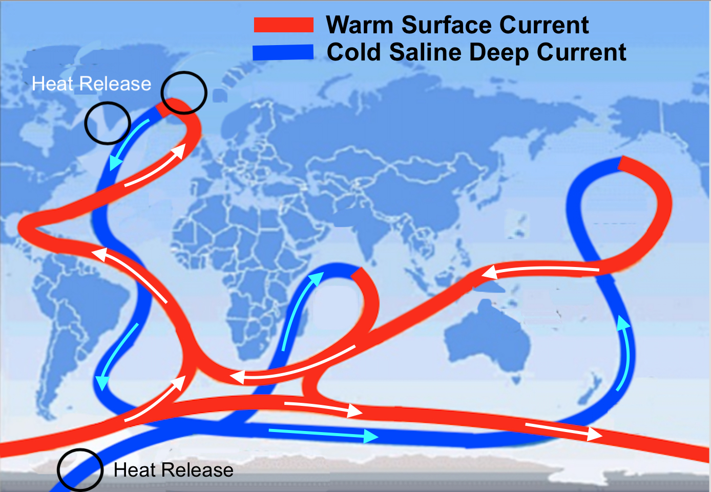
The Jet Streams steer the oceans low
pressure systems, but are highly complex and multi-layered living dynamic
systems barely understood, but are affected by sun activity, ocean
temperatures, the Great Ocean Conveyor and volcanic activity
Such would appear to have been the case as Nephi said, “there arose a great storm, yea, a great and terrible tempest” (1 Nephi 18:13). And as happens when a jet stream gets stuck over an area, there is one thunderstorm after another that sucks up the warm, humid air from the ocean and can move it hundreds of miles along its path, dumping water as it goes. When Nephi said, “after we had been driven back upon the waters for the space of four days, my brethren began to see that the judgments of God were upon them, and that they must perish save that they should repent of their iniquities; wherefore, they came unto me, and loosed me” (1 Nephi 18:15).
For those who have never been in a type of severe storm that never lets up for four straight days, it can become frightening, with no end in sight. It is not like the downpours most of us have experienced for a few hours, then is over. Such would have been the type of storm that Nephi described, so severe that it ended up frightening these hardened older brothers and their cohorts into succumbing to their younger brother whom they had grown to hate because of his preferential position among them.
Such would have been the type of weather in going around the Cape had they done so, and certainly not something they could have handled, especially since it would have taken days even a week to transit the Cape in such a storm. However, the reason and point for all this is to show that such a weather front as described, is far more likely in warm water areas, or tropical seas, such as the Indian Ocean toward the north, not as far down as the Cape of Africa.
It is also unbelievable that anyone would think an ocean-going vessel like the one Nephi built could have sailed from either the North Atlantic up the St. Lawrence River or from the Gulf of Mexico up the Mississippi River or from the Atlantic seaboard up one of the numerous inland waters (rivers) off the eastern seaboard and get to any of the Great Lakes, or even within hundreds miles of one.

On a flat map, it looks like the (Red Line) course around Africa and
across the Atlantic to North America is
shorter than than the (Blue Line) course down across the Indian Ocean, the
Southern Ocean and up to Chile; However, the Earth is curved and the distance
around the Southern Ocean is far less than around the Equator, resulting in the
Pacific course much shorter than the Atlantic course
It is highly unlikely Lehi went anywhere away from the landing site. As Nephi wrote: "And it came to pass that after we had sailed for the space of many days we did arrive at the promised land; and we went forth upon the land, and did pitch our tents; and we did call it the promised land" (1 Nephi 18:23). So given all that, how do you claim Lehi, Nephi and the others all got to the West Sea of the Great Lakes area (or the Heartland people think he got to Nauvoo/Zarahemla, Iowa area) to land?
So why don’t we put to bed this silly notion that Lehi sailed around Africa, across the Atlantic, and landed in North America. There is no way that could have happened in 600 BC, let alone by a novice crew with no experience at sailing.


I very carefully charted both courses on google earth and as much as I believe the Lehites came to Chile, it actually was somewhat farther going that direction than going to Florida.
ReplyDeleteGoogle Earth takes into account the curvature of the earth.
The straight around the earth distance from Salalah to the West coast of Florida is about 8220 miles. The straight around the earth distance from Salalah to Coquimbo bay over the Pacific is about 15,970 miles. (The straight around the earth distance from Salalah to Coquimbo bay going West is about 8,920 miles.)
But of course they do not go straight. The fact that the sailing distance going to Coquimbo Bay was not much farther than the distance going to Florida -- considering how much farther the straight around the earth distance is -- is remarkable enough for me.
But if you do not believe me, get an expert and have him check it out.
BoM Lands According to Scripture
The Southern Ocean (West Wind Drift) moves at twice the speed of the currents in the Atlantic--actual miles is not the issue, but that the time frame was so much less; the same is true with the Prevailing Westerlies, which blow continually at high speeds from west to east.
ReplyDeleteNo doubt it is faster following the natural ocean gyres and fast moving prevailing Westerlies.
DeleteSo when does someone like Heyerdal build a sailing boat and make the trip to show how easy and fast it would have been?
Great observations Del and George. I measured the route and they are roughly, kinda sorta the same distance. But the winds and currents are the key. And of course the absolute barrier to getting around the Cape is an enormous factor. All these things slam the door shut on most of the other models as far as I can see.
ReplyDelete