
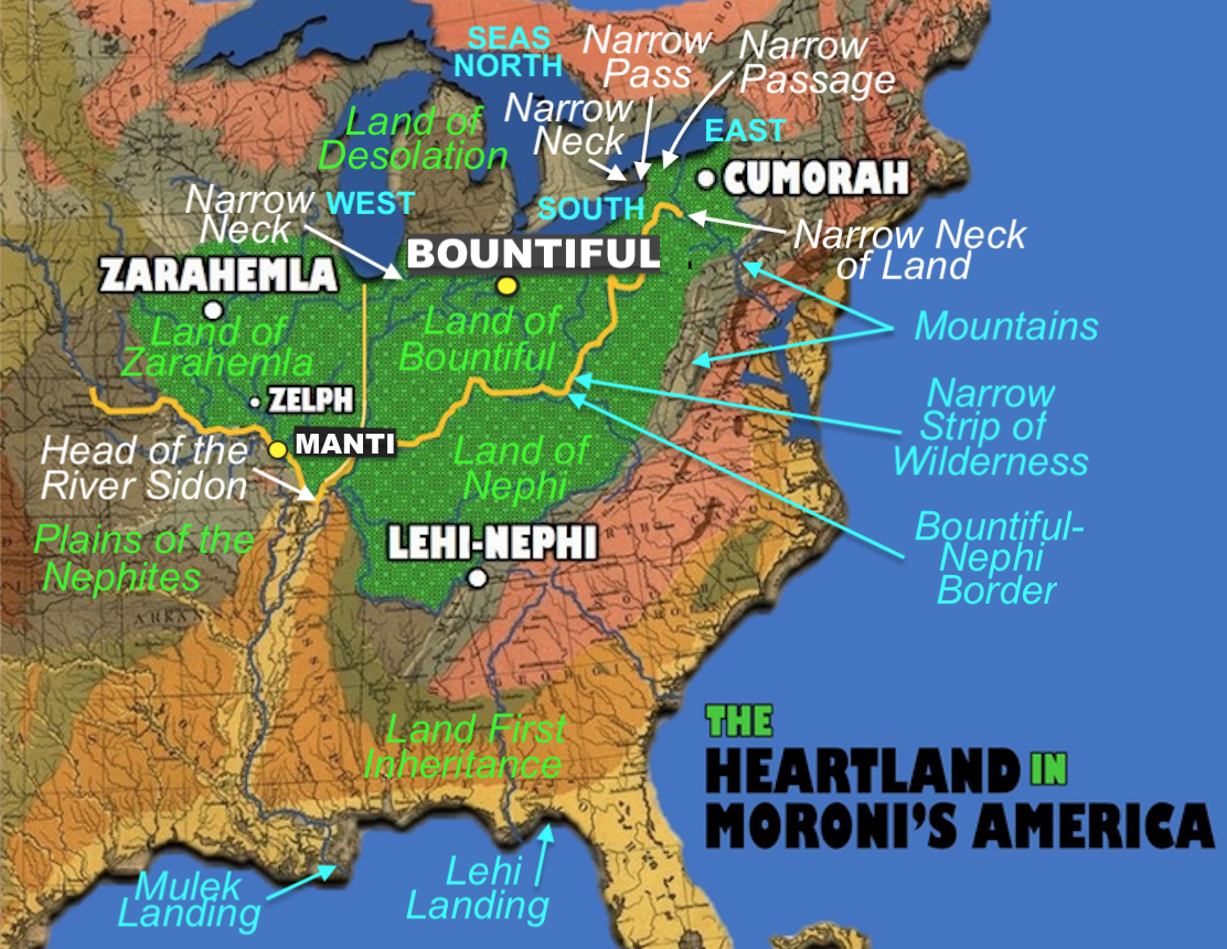
The combined map of Meldrum’s Heartland theory
2. Mulek Landing: Meldrum places this near New Orleans in Louisiana, and then had them travel up the Mississppi River to the area of Zarahemla, Iowa (across from Nauvoo). However, the Mississippi was too shallow with rapids along what is now Baton Rouge, making such transit by boat or ship impossible until the Corps of Engineers began dredging and deepening the river in the 1850s, with levees protecting the Delta after 1865, when towns grew, railways were built, and cotton production boomed and spread throughout the entire lower Mississippi Valley.
3. Plains of the Nephites: Meldrum considers this statement by Joseph Smith important enough to place it in a location on his map. However, there is no such place, reference or suggestion of such an area in the scriptural record. The term came from a letter Joseph Smith wrote to Emma while he was away from her on the Zion’s Camp journey in June of 1834. Joseph began his letter stating: “I embrace this opportunity to fill up this sheet to you, my beloved companion, not that I have anything important to communicate” and goes on to say she had asked him to write and that he was also writing to Oliver Cowdery each week. He went on to discuss the money he was sending her, that he missed her and looked forward to returning, also for her to remind the children of the passage about “obeying your parents in all things,” and also that they had been treated with respect on this journey, that he had little room to write and that he would write more when they reached their journey’s end, then went on to described the arrangement of the camp, its food and where they obtain it so as not to bother people on the way.

The flat ground around Griggsville, Illinois, which is the location of the
Zelph Mound. Note how flat it is in west central Illinois to the east of the
Mississippi River, southeast of Montrose, Iowa (Zarahemla)
As can be seen, this reminiscing note was not describing anything geographically. The day before they had discovered the bones of Zelph, the white Lamanite and believed that gave proof of the book (History of the Church, vol.2, pp79-80).
4. Head of the River Sidon: Meldrum places the head (or source) of the Mississippi at the confluence of the Ohio and Mississippi Rivers; however, this marks the place of the mouth of the Ohio, as it empties into the Mississippi as a tributary river. It is neither the head, source, or beginning of the Mississippi, which runs southward instead of the northward direction as Mormon so clearly states—the river ran north and south, having a West bank (Alma 2:34, 8:3), and an east bank (Alma 6:7; 16:7); being to the south of the Land of Zarahemla (Alma 22:27); and running by not the city, but the land of Zarahemla (Alma 2:15) meaning it did not run by or near the city; and was not only up in elevation from Zarahemla, but “away up” (Alma 16:6).
5. Manti: Meldrum has the city of Manti to the south of where Zelph was located and between the city of Zarahemla and the head of the River Sidon. While it is not the location of his placement, but the terrain of the location that is not consistent with Mormon’s descriptions. First of all, Manti was to the south of the land of Gideon (Alma 17:1); Gideon is at a higher elevation than Zarahemla (Alma 62:6-7); Gideon is east of the River Sidon (Alma 2:26; 6:7), Manti was south of Gideon (Alma 17:1); and near the head or source of the River Sidon (Alma 22:27; 43:22). Thus, Manti was south of Zarahemla as depicted.

Top: 1900 View from Montrose
(Zarahemla) Iowa across the Mississippi looking north; Bottom: View of Montrose
looking south. Note the flat ground, which is the case in any direction—there
simply is no elevated ground, hills, high hills, or mountains in the vicinity
for more than a hundred miles
6. Land of Zarahemla: Meldrum has the Land of Zarahemla landlocked below his West Sea, with only rivers in that area of the land. He also has the Land of Zarahemla to the west of the Land of Nephi, west of the Land of Bountiful, and west of the Sea West. However, Mormon has the Land of Zarhemla with the West Sea on the west, the East Sea on the east, and nearly surrounded by water (Alma 22:32

Meldrum lists 2 Narrow Passes and 2
Narrow Necks, separating the terms Pass and Passage, though the words mean the
same thing; and separating Small and Narrow, though again the words mean the
same thing
However, in reality, there are only two locations, one small or narrow neck of land, and a pass or passage through it. In fact, there is nothing in the scriptural record that would give rise to an assumption of different places other than referring to the same place in different ways, such as small and narrow, which are both descriptions of the same place. That is, it was both small and narrow. And a Pass is a passage.
8. The West Sea: Meldrum places his West Sea to the northwest of his Land of Bountiful, and both west and north of his Land of Zarahemla. However, under the general antiquitous, as well as Hebrew, methods of naming places by direction, the West Sea would have to be west of the Land of Zarahemla to be considered in the west of the main body of the Nephite Nation for hundreds of years. Mormon makes this quite clear when he states in his insert: “on the west of the land of Zarahemla, in the borders by the seashore” (Alma 22:28). In addition the West Sea was in the borders of the land on the south (Alma 53:22), not north as Meldrum has his west sea.
(See the next post, “The Erroneous Heartland Map – Part II,” for more information on Meldrum’s map and its many errors from the scriptural record)


No comments:
Post a Comment