
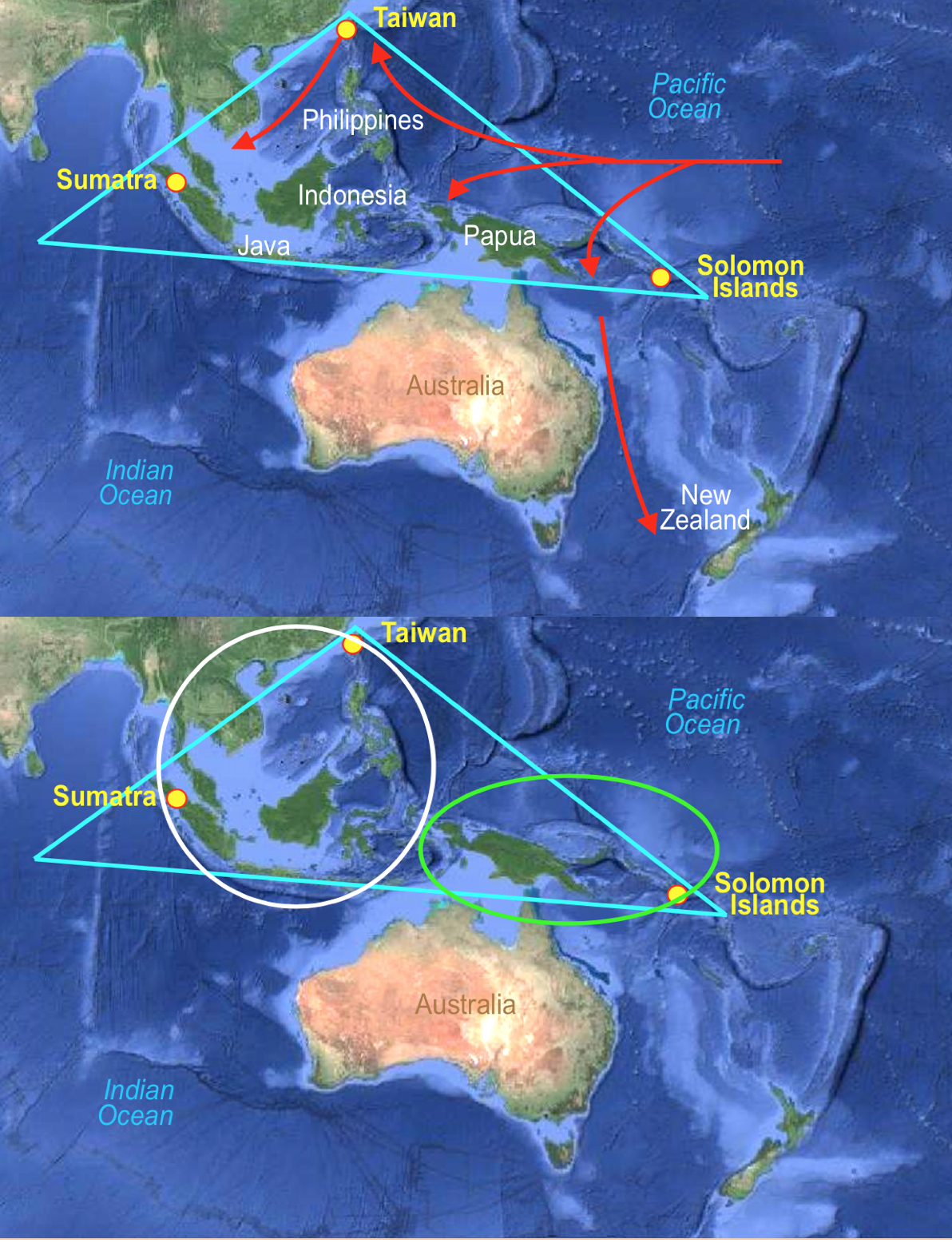
Top: The Coral Triangle and the (Red arrows) showing the major ocean
currents through the Triangle; Bottom: The two biological divisions of the
Triangle
To determine who settled in this area, Archeaologists clam that the Lapita vase was found throughout this region, however, similar styles are also present in these islands, suggesting that a single people had various pottery styles, or that many cultural groups settled in this area. It does not singularly suggest that the Lapita people migrated south and east from Taiwan.

Similar style vases found in the
Coral Triangle (first four: the Coral Triangle—Lapita Vase, Timor Islands, Solomon
Islands, Papua New Guinea) and the last two on Marajó Island, South America, and
Maya Guatemala
Response: More correctly, they have Lapita pottery, as though no one else in the world were capable of making or developing that specific pottery. In addition, there is no reason to believe that the development of people went from the west to the east through these islands, but with winds and currents, it is far more liely that people moved through these island from east to west.
8. “At predictable times each year the trade winds would reverse from south-easterly to westerly.”
Response: This is not true across the Pacific, only in the western Pacific because of the existence of the Coriolis Effect, and specially in Melanesia and around Australia (The Coriolis Effect is when the surface air that flows from these subtropical high-pressure belts toward the Equator is deflected toward the west in both hemispheres by the Coriolis effect). Much further east and the prevailing winds and currents do not reverse themselves at all.
In fact, trade winds in the Indian Ocean and through Indonesia blew southwest to northeast for six months and blew from northeast to southwest six months—these did not affect the western Pacific islands. On the other hand, there were winds that swirled among the islands themselves, making it easier to sail from island to island, but not from island group to island group. Too many historians make the mistake of understanding north-south sailing from Polynesia to Hawaii and back and being able to sail against winds and currents, however, sailing across winds and currents is vastly different than sailing against them!
9. “At these times canoes could set off with the wind behind them, and explore to the east.”

Captain Cook and his HMS Endeavor sailing through the islands of the South
Pacific
10. “When the winds reverted to south-easterly, a safe return could be made.”
Response: First, the “trade winds” have nothing to do with ancient trade routes. The word “trade,” originally derives from the early fourteenth century in late Middle English, where the word meant "path" or "track." The Portuguese recognized the importance of the trade winds (then the Volta do mar, meaning in Portuguese "turn of the sea" but also "return from the sea") in navigation in both the north and south Atlantic ocean as early as the 15th century (Hermann R. Muelder, Years of This Land—as Geographical History of the Unites States, 2007, Read Books, 2007, Read Books, p38).
In fact, Volta do mar was a navigational technique perfected by Portuguese navigators during the Age of Sail in the late fifteenth century in order to return from the Atlantic Islands, where the pilot first had to sail far to the west in order to catch usable following winds, and return to Europe.
This was a counter-intuitive sailing direction, as it required the pilot to steer in a direction that was perpendicular to the ports of Portugal. Lack of this information may have doomed the thirteenth-century expedition of Vandino and Ugolino Vivaldi, who were headed towards the Canary Islands (then unknown to the Europeans) and were lost; once there, without understanding the Atlantic gyre and the volta do mar, they would have been unable to beat upwind to the Strait of Gibraltar and home. Discovering this technique was crucial for returning from future discoveries—for example Christopher Columbus would never have returned from the Americas without applying the volta do mar by sailing northwards from the Caribbean through the Horse Latitudes to catch the prevailing mid-latitude Westerlies.
Similarly in the South Atlantic with the exception that the South Atlantic gyre circulates counter-clockwise. As India-bound Portuguese explorers and traders crossed the equator with the intention of passing the entire western coast of Africa, their voyages took them far to the West in the vicinity of Brazil.
Thus knowing about and using the great permanent wind circle and the North Atlantic Gyre was a major step in the history of navigation, when an understanding of winds in the period was crucial to success—the European sea empires never would have been established had the Europeans not figured out how the trade winds worked (Lewis Dartnell, Origins: How Earth’s History Shaped Human History, Basic Books, (2019), pp218–222).

Dk Blue Arrow: Early sailing from Mexico to the Philippines; Black
arrow: Return voyage to Mexico; Red Arrow: North Pacific Gyre (clockwise
current); Lt. Blue Arrow: South Pacific Gyre (counter clockwise current); Large
Black Dotted Arrow: Lehi’s voyage to the Land of Promise
The route of the Manila Galleon from the Philippines to Mexico depended upon successful application of the Atlantic phenomenon to the Pacific Ocean in discovering the North Pacific Gyre captains of returning galleons had to reach the northern latitudes of Japan before they could safely to east and cross the Pacific back to the Americas. The discovery, upon which the Manila-Acapulco galleon trade was based was owing to the Spanish Andrés de Urdaneta, who sailing in convoy under Miguel López de Legazpi, discovered the return route in 1565: the fleet split up, some heading south, but Urdaneta reasoned that the trade winds of the Pacific might move in a gyre as the Atlantic winds did. If in the Atlantic, ships made the Volta do mar to the west to pick up winds that would bring them back from Madeira, then, he reasoned, by sailing far to the north before heading east, he would pick up trade winds to bring him back to the west coast of North America. Though he sailed to 38º North before turning east, his hunch paid off, and he hit the coast near Cape Mendocino, California then followed the coast south to Acapulco, Mexico. Most of his crew died on the long initial voyage, for which they had not sufficiently provisioned.
Secondly: There are no gyres within the western South Pacific other than the much larger South Pacific Gyre, and without that, there is no return. Consider Columbus’ voyage to the Americas (Caribbean) where he rode the southern arm of the clockwise northern Atlantic Gyre across, then circled northward and back across on the northern arm of the Gyre—it was not a reversal of currents and winds, but the way in which the current and wind flowed. The Trade Winds are unique winds and should not be mixed up with any old reversal desired—they exist because of the Coriolis Effect of gravity in the two hemispheres (southern and northern) and follow a distinct pattern, which reversal really is found only in the Indian Ocean as we had discussed here many times.

The 4300 miles, 101 day drift voyage of the Kon Tiki from Callao, Peru,
to the Masrqueses Islands in Polynesia
(See the next post, “Polynesia Settled from South America – Part V,” for more on the lack of reasoning behind claiming that early man island-hopped across the Pacific from west to east)


Thank you Del for this series on this important subject. This generation of LDS people are too young to remember the exploits of Heyerdahl. I doubt if any would know of the interviews with him in the New Era.His 1953 book American Indians in the Pacific was and is the masterpiece of info on this subject in my opinion. Thanks again!
ReplyDeleteI would like to see this series on the Polynesian people put into paper print somehow.Unfortunately all the the younger folks and older ones too spend most of their time staring at their cell phones ,tney cant read a book. There needs to be a thousand subscribers to this blog for every one that is here, we need to get the word out. Del you are a gold mine.
ReplyDeleteI would be of the opinion that the indigenous people of Taiwan were from polynesia and So. America rather than the other way around. They certainly look and seem polynesian to me .I do know they have the musical gift of beautiful singing as do the other island peoples I have known.Myself being a musician that the first thing I observed of course.
ReplyDelete